Status of monument -> National monument
Pursuant to Article V para. 4 Annex 8 of the General Framework Agreement for Peace in Bosnia and Herzegovina and Article 39 para. 1 of the Rules of Procedure of the Commission to Preserve National Monuments, at a session held from 3 to 9 May 2005 the Commission adopted a
D E C I S I O N
I
The architectural ensemble of the Old Zvornik Fort is hereby designated as a National Monument of Bosnia and Herzegovina (hereinafter: the National Monument).
The National Monument consists of the walls and buildings of the old Zvornik fort and the movable heritage housed in the National Museum and Library collections in Zvornik.
The National Monument is located on a site designated as cadastral plot nos. 1969, 1962, 2019, 2020, 2021, 2022, 2023 (new survey), corresponding to c.p. 96/3 (old survey), Land Register entry no. 61, c.p. nos. 96/1 and 96/2, Land Register entry no. 60 (old survey) cadastral municipality Zvornik, Municipality Zvornik, Republika Srpska, Bosnia and Herzegovina.
The provisions relating to protection measures set forth by the Law on the Implementation of the Decisions of the Commission to Preserve National Monuments, established pursuant to Annex 8 of the General Framework Agreement for Peace in Bosnia and Herzegovina (Official Gazette of Republika Srpska no. 9/02) shall apply to the National Monument.
II
The Government of Republika Srpska shall be responsible for ensuring and providing the legal, scientific, technical, administrative and financial measures necessary to protect, conserve, and display the National Monument.
The Commission to Preserve National Monuments (hereinafter: the Commission) shall determine the technical requirements and secure the funds for preparing and setting up signboards with the basic data on the monument and the Decision to proclaim the property a National Monument.
III
Protection Zone I consists of the area defined in Clause 1 para. 3 of this Decision. The following protection measures shall apply in this zone:
- all works are prohibited other than research and conservation and restoration works, including those designed to display the monument, with the approval of the Ministry responsible for regional planning in Republika Srpska (hereinafter: the relevant ministry) and under the expert supervision of the heritage protection authority of Republika Srpska (hereinafter: the heritage protection authority),
- the site of the National Monument shall be open and accessible to the public and may be used for educational and cultural purposes,
- the dumping of waste is prohibited.
Protection Zone II consists of a protective strip with a width of 50 m from the boundaries of the area constituting Protection Zone I in the Lower and Upper Fort. In this zone:
- all construction or works that could have the effect of altering the site or the environs are prohibited;
- works of any kind to the infrastructure are prohibited unless with the approval and the the expert opinion of the heritage protection authority,
- the dumping of waste is prohibited.
To ensure the on-going protection of the National Monument, the following shall be implemented:
- clearing the ramparts of the fort, the walls of the tower, the other premises and the surroundings of self-sown vegetation endangering the structure of the monument;
- structural repairs to the tower and ramparts where cracks have appeared that risk causing the entire structure to collapse;
- drafting and implementing a programme for the presentation of the National Monument.
IV
The removal of the movable heritage referred to in Clause 1 para. 2 of this Decision (hereinafter: the movable heritage) from Bosnia and Herzegovina is prohibited.
By way of exception to the provisions of paragraph 1 of this Clause, the temporary removal from Bosnia and Herzegovina of the movable heritage for the purposes of display or conservation shall be permitted if it is established that conservation works cannot be carried out in Bosnia and Herzegovina.
Permission for temporary removal under the conditions stipulated in the preceding paragraph shall be issued by the Commission to Preserve National Monuments, if it is determined beyond doubt that it will not jeopardize the movable heritage in any way.
In granting permission for the temporary removal of the movable heritage from Bosnia and Herzegovina, the Commission shall stipulate all the conditions under which the removal may take place, the date by which the movable heritage shall be returned to Bosnia and Herzegovina, and the responsibility of individual authorities and institutions for ensuring that these conditions are met, and shall notify the Government of Republika Srpska, the relevant security service, the customs authority of Bosnia and Herzegovina, and the general public accordingly.
V
All executive and area development planning acts not in accordance with the provisions of this Decision are hereby revoked.
VI
Everyone, and in particular the competent authorities of Republika Srpska, and urban and municipal authorities, shall refrain from any action that might damage the National Monument or jeopardize the preservation and rehabilitation thereof.
VII
The Government of Republika Srpska, the Ministry responsible for regional planning in Republika Srpska, the ministry responsible for culture in Republika Srpska and the heritage protection authority, and the Municipal Authorities in charge of urban planning and land registry affairs, shall be notified of this Decision in order to carry out the measures stipulated in Articles II – VI of this Decision, and the Authorized Municipal Court shall be notified for the purposes of registration in the Land Register.
VIII
The elucidation and accompanying documentation form an integral part of this Decision, which may be viewed by interested parties on the premises or by accessing the website of the Commission (http://www.aneks8komisija.com.ba)
IX
On the date of adoption of this Decision, the National Monument shall be deleted from the Provisional List of National Monuments of Bosnia and Herzegovina (Official Gazette of BiH no. 33/02, Official Gazette of Republika Srpska no. 79/02, Official Gazette of the Federation of BiH no. 59/02, and Official Gazette of Brčko District BiH no. 4/03), where it featured under serial no.773.
X
Pursuant to Art. V para 4 Annex 8 of the General Framework Agreement for Peace in Bosnia and Herzegovina, decisions of the Commission are final.
XI
This Decision shall enter into force on the date of its adoption and shall be published in the Official Gazette of BiH.
This Decision has been adopted by the following members of the Commission: Zeynep Ahunbay, Amra Hadžimuhamedović, Dubravko Lovrenović, Ljiljana Ševo and Tina Wik.
No: 05.1-02-104/05-6
3 May 2005
Sarajevo
Chair of the Commission
Ljiljana Ševo
E l u c i d a t i o n
I – INTRODUCTION
Pursuant to Article 2, paragraph 1 of the Law on the Implementation of the Decisions of the Commission to Preserve National Monuments, established pursuant to Annex 8 of the General Framework Agreement for Peace in Bosnia and Herzegovina, a “National Monument” is an item of public property proclaimed by the Commission to Preserve National Monuments to be a National Monument pursuant to Articles V and VI of Annex 8 of the General Framework Agreement for Peace in Bosnia and Herzegovina and property entered on the Provisional List of National Monuments of Bosnia and Herzegovina until the Commission reaches a final decision on its status, as to which there is no time limit and regardless of whether a petition for the property in question has been submitted or not.
The Commission to Preserve National Monuments issued a decision to add the architectural ensemble of the Old Zvornik Fort to the Provisional List of National Monuments of BiH under serial no. 773.
Pursuant to the provisions of the law, the Commission proceeded to carry out the procedure for reaching a final decision to designate the Property as a National Monument, pursuant to Article V of Annex 8 and Article 35 of the Rules of Procedure of the Commission to Preserve National Monuments.
II – PROCEDURE PRIOR TO DECISION
In the procedure preceding the adoption of a final decision to proclaim the property a national monument, the following documentation was inspected:
- Documentation on the location and current owner and user of the property (copy of cadastral plan and copy of land registry entry)
- Data on the current condition and use of the property, including a description and photographs, data of war damage, data on restoration or other works on the property, etc.
- Historical, architectural and other documentary material on the property, as set out in the bibliography forming part of this Decision.
The findings based on the review of the above documentation and the condition of the site are as follows:
1. Details of the property
Location
Zvornik is 74 km south of the confluence of the Drina and the Sava. The fortress stands on the mountain massif of Mlađevac, on an almost impassable site, where the Drina emerges from the gorge into the fertile plains where a civilian settlement took shape. To the north, Mlađevac is bordered by the lower course of the Bjelobarska river, to the east by the Drina, to the west by the Mekinja brook and the road leading to the village of Sultanovići, and to the south by the lower course of the river Jošanica.
The upper reaches of the Drina from its confluence with the Sava downstream to Zvornik was navigable in antiquity, and there is information to that effect from later periods as well (Bojanovski, 1981, p.190, Çelebi, 1979, p. 484). The Drina crossing and its strategic position conferred considerable importance on Zvornik during the mediaeval period, and particularly during the Ottoman period. The fort guarded the route from Serbia to Bosnia via Sarajevo and Dubrovnik, and the route to Tuzla and Srebrenica, and controlled the road along the left bank of the Drina to Srijem (the Dubrovnik road) as well as the major transverse route from the Spreča valley to Kolobar, which crossed into Serbia by ferry.
Historical information
Prehistoric erea and antiquity
The site of the fortress and former outskirts (the varoš or town) in Zvornik has not been investigated to any great extent. Plains and hillfort dwellings and burial moundsdating from the Neolithic, Eneolithic, Bronze and Iron ages have been found in the Zvornik area, between the river Sapna to the north and Drinjača to the south. Sites dating from antiquity have also been sparsely studied. The majority have been discovered in the Sapna valley and by the left bank of the Drina. These last, together with prehistoric sites and hodological studies, have helped to establish the routes taken by antique-era communications, which were probably also used in prehistoric times. In antiquity and later (Çelebi probably took the same route) a road ran from the Drinjača area to Zvornik, where the Ad Drinum waystation was located, and on towards Mačva and the confluence of the Drina and the Sava (Bojanovski,1981, pp. 180,185).(1) Here lived the epichorial Pannonian tribes of the Amantini and Sirmiensi, while in the latter centuries BCE the Scordisci inhabited both banks of the Drina round Zvornik (Bojanovski,1988, p.236). The Zvornik area, probably as far as Drinjača, belonged to the province of Pannonia, while as a result of later administrative divisions it was in the territory of Pannoniae Inferior and Pannoniae Secundae in the ager of the Sirmiensis colonia (Bojanovski,1988, p. 342). The assumption is that it was in the light of these circumstances that some prehistoric hillforts, and later Roman fortifications, have been identified in Zvornik(2).
The only find in present-day Zvornik, and that was discovered quite by chance, was of a late antique tomb vault dating from the 5th to 6th century, discovered during building works in Zamlaz mahala.
Mediaeval period
The Zvornik area was in the early mediaeval župa (county) of Podrinje or Sapna, which occupied the geographical region between the river Drina and the easternmost spurs of Mt. Majevica. The northern boundary was on the watersheds between the Tavna and Sapna river basins, and to the south the boundary was the beds of the river Drinjača and Jadar. This area, which corresponds in size to the old Bosnian župas, later became the centre of a more extensive district (the Zvornik kadiluk). The old county organization was broken up, at the latest in the first half of the 14th century, into the districts of Kušlat, Zvornik and Sapna, and soon thereafter, in the mid 14th century, the central Podrinje (Drina valley) region was merged with the Usora district. Zvornik belonged to the Podrinje district which, from 1366 until Bosnia ceased to be an independent state, appears in the titles of the kings of Bosnia (Anđelić, 1977, pp. 19, 25; idem, 1977.a, pp. 264, 266-267; Handžić, 1975, p. 23).
In the late mediaeval period Zvornik was a separate administrative county (kotar, župa, knežija) which, together with the county towns (forts) of Šubina and Kušlata, plus Srebrenica and Ludmera, belonged to the domain for which the rulers of Bosnia, Hungary-Croatia and Serbia intermittently contended (Anđelić, 1977, p. 262; idem 1977a, p. 258)(3). At this time, in addition to the fortress in Zvornik, favourable trade and general economic circumstances led to the development of a town on the outskirts, Subsuonich, with a large and well-to-do colony of people from Dubrovnik and a high degree of self-government, with its own mayor and borough council. All this places the fort and town on the outskirts in Zvornik among the most advanced settlements in Bosnia at that time.
The earliest reference to Zvornik in historical sources dates from 1410. During the rein of Serbia's King Dragutin (1284-1316), it is not possible to determine accurately the border between Dragutin's possessions and Bosnia. The assumption is that his rule extended roughly over the Koraj, Teočak and Bijeljina area, and perhaps to Soli in the west, which would mean that Zvornik was not under his rule (Handžić, 1975, p. 95).
In 1410, Hrvoje Vukčić gifted the forts and markets of Srebrenica and Kušlat in north-eastern Bosnia, and the fortresses of Brodar and Susjed, to Hungary's King Sigismund, who had conquered Srebrenik in 1405. He established the Usora district in the north under direct Hungarian rule (Ćirković, 1964, p. 214). During a conflict between Bosnia's King Tvrtko II and despot Đurađ in 1432-1433 around Srebrenica, the king was defeated somewhere near Zvornik. The despot occupied the Zvornik district, and Srebrenica and the eastern part of Usora west of the Zvornik – Teočak line as far as the Sava in the north remained in his hands. From then on despot Đurađ called himself lord of Zvornik and all Usora. The Zvornik area was under his rule from 1432 to 1458, a total of 26 years, and the Srebrenica area from 1410 to 1458. The rule of Serbia's despots on the left bank of the Drina was not unbroken. From 1410 to 1460, Srebrenica changed hands several times, being under Serb rule five times, Bosnian four times and Ottoman three times. As early as 1438, while making preparations to occupy the despotate, the Ottomans crossed over to the Bosnian site of the Drina. It is not clear what happened to Zvornik at that time. The assumption is that it came into the hands of the king of Bosnia. There is no reference to Zvornik between 1435 and 1461 (Handžić, 1975, pp28, 94).
While Europe's mines were becoming increasingly run down from the mid 14th century, in Bosnia the mines where there was intensive production at that time and, particularly, in the 15th century became powerful economic centres. Many places, although with no direct mining production, developed into advanced commercial centres, where precious metals were traded. Among them Visoko and Zvornik were of major importance. Zvornik's economic rise, as well as the proximity of Srebrenica, was further enhanced by its favourable location on the intersection of major routes to Bosnia, Serbia and Hungary. It was thus that from 1410 to 1430 Zvornik developed into an important trading centre in the central Podrinje area (Kovačević - Kojić, 1978, pp. 58-59). The presence of a powerful Dubrovnik colony in Zvornik can be traced from 1415 to 1532. During this time up to 640 members of the colony of Dubrovnik merchants were based there. Since at this time Srebrenica was under the rule of the despotate, the view is that it was in Zvornik that the most powerful Dubrovnik settlement in mediaeval Bosnia took shape. Nor was it only Dubrovnik's merchants who were interested in Zvornik, but also the city's artisans and craftsmen. Goods for Zvornik were transported via Olovo and Glasinac. The town became the focal point for trade from Dubrovnik on a wide scale. Silver, particularly mined in nearby Srebrenica, was the basic product traded by the merchants of Dubrovnik, but they also traded in several other types of goods, including significant quantities of arms, knives and horse harness (Kovačević - Kojić, 1978, pp. 196, 197, 329, n.103 ).
As well as trading with Srebrenica, with which they were closely associated, Dubrovnik's merchants also did business with other places in Bosnia and Serbia: Visoko, Krupanj, Belgrade, Rudnik, Priština, and also with Ilok and Hungary (Kovačević - Kojić, 1978, p. 166).
After 1430, the abrupt rise of mining towns, in this case Srebrenica, coincided in time with the decline of Zvornik which, along with Visoko, had until 1430 been the main centre of Bosnia's trade (Kovačević - Kojić, 1978, pp. 60, 73). After 1432, when Zvornik was merged into the despotate, the Dubrovnik merchants abandoned it for Srebrenica. The reasons were purely economic, not political, since Srebrenica too was in the despotate.
A document dating from 1446, at a time when Zvornik belonged to the Serbian state, but under ever greater pressure from the Ottomans, features a vojvoda (military leader, cf. Lat. Dux) who was both fortress commander and government representative (Kovačević - Kojić, 1978, p. 253). A number of documents from the Dubrovnik archives record that this or that merchant of that city built a house in the town on the outskirts of the Zvornik fort. Here, about 1.5 km from the fortress itself, there was also a Franciscan monastery and church of St Mary (Kovačević-Kojić, 1978, pp. 264-265). The exact date when the monastery was built is not known. The earliest reference to it in the Dubrovnik archives dates from 1423. Basler believes that the S. Maria in Campo in the list of Franciscan monasteries drawn up by Bartulo of Pisa in the late 14th century refers to the monastery in Zvornik (Kovačević - Kojić, 1978, p. 60; Basler, 1973, p. 203).
The significance and importance of individual urban settlements can be judged from the fact that after conquering the area, the Ottomans took some of them over as their administrative centres, some higher, some lower ranking. Zvornik became the centre of a sandžak (Kovačević - Kojić, 1978, p. 347).
Ottoman period
When the despotate finally fell to the Ottomans in 1459, so too did its regions on the left bank of the Drina, the mining Podrinje area and parts of the Usora district, probably in early 1460 (Dinić, 1955, p. 86). These areas were merged with the Smederevo sandžak, remaining within its borders until 1480. A census of the Smederevo sandžak conducted in 1476/77 reveals that Vlachs were serving as martolosi, and receiving a salary, in the fortress in Zvornik and in Srebrenica (Handžić, 1975, pp. 99, 100). After most of Bosnia and Herzegovina had fallen to the Ottomans in 1463, the Hungarians and local forces launched a counteroffensive. The Jajce, Srebrenik and Šabac banates were founded. In the autumn of 1464, Hungary's King Matthias Corvinus assembled a large army which, commanded by Ivan Zapolja, unsuccessfully besieged the Zvornik fort. Sultan Mehmed II urgently dispatched an army to Zvornik under the command of Mahmud pasha Anđelović, accompanied by the sandžakbey of Smederevo, Mihail-oglu Ali-bey, whose troops broke the Hungarian siege of the fort (Truhelka, 1904, p. 19; Thalloczy, 1916, pp. 192-196).
The Hungarians were a constant threat to the northern borders of the possessions of the conquered Ottoman districts, mainly moving along the Drina valley. In 1476 Vuk Grgurević briefly besieged Zvornik, torched Srebrenica and reached the outskirts of Kušlat. As a result of these incursions, and the need to reinforce the defences and organize their newly-acquired possessions more effectively, the Ottomans founded the Zvornik sandžak in or around 1480 (Handžić, 1975, p. 43). The Zvornik sandžak originated by merging the western areas of the Smederevo sandžak in the central Podrinje, in other words the mining and mountainous areas on both sides of the Drina, and some areas of the north-eastern Bosnian sandžak, into a separate administrative unit headquartered in Zvornik. Judging from the earliest known, though undated, census of the Zvornik sandžak, which could date from between 1480 and 1512, the original heartland of the sandžak included the Srebrenica, Brvenik and Zvornik kadiluks, the last of which must have been founded in 1460, although the earliest reference to it dates from 1477(4). A document dated 25 May 1491 refers to Balibeg mir-i liva of the Zvornik fort [sandžak] and Mevlana Sule, kadi of the Zvornik fort, and two silahdars (high-ranking courtiers of the Sultan or officials of the governor), members of the board under whose supervision the fortified towns of Zvornik and Srebrenica were repaired from May to September that year (Handžić, 1975, p.49).
The sandžak acquired its final territorial form in 1521 with the fall of Šapac and Belgrade to the Ottomans. The whole of Mačva was also conquered at this time, and the Ottomans added two of Mačva's nahiyes and part of the Posavina in Bosnia to the Zvornik sandžak (Handžić, 1975, pp. 42-49, 55). Until 1526 (the battle of Mohács) and 1537 (the conquest of Slavonia), the sandžak was an outlying military frontier region. The census of 1512 makes no reference to timar garrisons in the forts in the immediate environs of Zvornik (Perin, Kušlat and Srebrenica), nor indeed to Zvornik itself. This means that they were garrisoned by ulufedžija (salaried) troops, with all the military branches: mustahfiz (fortress guards, the main branch of the local armed forces), azap (infantry), faris (cavalrymen), martolos and tobdžija (artillerymen), as in every frontier district. At some time prior to 1533 the troops of the fortress garrison in Zvornik acquired permanent timars (feudal estates providing an income for their cavalryman holders, known as spahis). At that time Zvornik had a standing garrison crew of 120 mustahfiz-timarlijas. The largest recorded number of 156 mustahfiz was in Zvornik, as a major frontier fort, in 1477. It had the same number of infantrymen, about 100 martolosi, and rather more cavalrymen than martolosi. They would be accompanied by one or two oda (squads) of artillerymen. In all, during the time of the serhat (military frontier), Zvornik had a garrison of some 500 men. The 1533 census records thatthere were 118 mustahfiz in the fortress and rather fewer members of the other military branches. The numbers of the fortress garrison were soon reduced to almost a quarter of its former strength, when Zvornik lost its strategic importance with the shifting of the borders to the Sava and further north (Handžić, 1975, pp. 160-163).
At the time when this region was a military frontier, the headquarters of the government authorities and Muslim cultural institutions were located solely within fortified towns. The upper fort of the Zvornik fortress had a mosque, the Mehmed II el Fatih mosque, erected between 1460 and 1480. A residential quarter grew up around it, recorded in the censuses as Mahala of the mosque of Sultan Mehmed Khan. The mahala had its own shops selling groceries and provisions, a food store, and a well (Handžić, 1970, p. 158).
In the lower fort, the exact date of which has not been determined, a mosque was built by the Carska (Emperor's) gate. The riparian part of the fort was probably built in the late 15th and 16th century. A document dating from 1491 records the payment of considerable sums for building materials and craftsmen (Mazalić, 1956, pp. 250-255; Handžić, 1970, p. 158).
As a consequence of the rapid urban development of the outskirts of Zvornik into a kasaba (town), St Mary's church and monastery were abandoned by the Franciscans in about 1538 (Handžić, 1975, pp. 72-73, 91).
From the military and administrative point of view, from its foundation until 1541 the Zvornik sandžak belonged to the Rumelia pashaluk. When the Budim pashaluk was founded, the Zvornik sandžak became part of it. In 1580, when the Bosnia pashaluk was founded, the Zvornik sandžak was merged with it. The post of sandžakbeg changed hands so often that it is impossible to provide a complete list. From 1490 to 1700, the names of only 19 of Zvornik's sandžakbegs can be given. Until the end of the 16th century they were headquartered in the fortress, and later, as required, in Donja Tuzla, Šapac or the kasaba on the outskirts of the Zvornik fort.
The first known Zvornik sandžakbeg was Bali-beg in 1491, after whom there is reference to Mustafa-beg in 1501, Sinan-beg in 1514, and Hajji Mustafa-beg in 1517. At the end of 1517 it was reported that the Zvornik sandžakbeg Öksünur-beg had been killed. Murad-beg is referred to in 1526, and Küçük Bali-beg was Zvornik sandžakbeg in 1528. He left endowments in Zvornik and elsewhere, and died as Budim beglerbeg (pasha) in Budim in 1541. Prior to 1533, Bahši-beg built a Sufi tekke with musafirhana (hostel) and other buildings in Zvornik, and constituted a vakuf for all this. There followed ? in 1533, Džafer-beg in 1534, Hizir-beg in 1543, and Sinan-beg in 1548. Ahmed-beg, great-grandsone of Sultan Selim I, is referred to as holding the post in 1558, followed by Husein Shah in 1559, Šaban-beg in 1565, Hizir-beg in 1567and c. 1570, Iskender-beg in 1571, Džafer-beg until 1574, when Iskender-beg was reappointed; Ferhad-beg in 1585, Sinan-beg in 1592, Memi-beg in 1593. After 1593, the names of Mehmed-beg in 1606 and Omer-beg in 1637 are known (Handžić, 1975, pp. 59-64; Mazalić, 1955, p. 91). The Zvornik sandžak was abolished in 1851.
The nahija of Zvornik belonged to the imperial has (Ar. khas), state lands retained by the Sultan as his personal feudal estates. It differed from the usual type of territorial-administrative unit known as nahija (Tur. nahiye). The Zvornik nahija took in the settlements along the main road from Novo Selo (south of Zvornik) to the town of Teočak.
An Orthodox priesthood is recorded in Ottoman censuses in Zvornik in about 1480. Although the exact date of the founding of the Zvornik episcopate is not known, according to Handžić it must have been very soon after 1480. Its jurisdiction presumably coincided with the territory of the sandžak. The earliest information on the bishops of Zvornik dates from the late third and early fourth decade of the 16th century. There is reference to Bishop Teofan of Zvornik in 1541 and to Metropolitan Pavle of Zvornik in 1561 (Handžić, 1975, pp. 105-114, Mazalić, 1955, p. 88).
According to the 1533 census, until when Zvornik was of considerable military strategic and administrative importance, the outskirts of the fort constituted a settlement with 133 Muslim households, 29 Christian, and 7 individual households (mudžereda). Zvornik acquired the status of kasaba in the mid 16th century. According to the 1548 census, the kasaba had eight mahalas, known by the names of crafts, with 432 Muslim households, and one Christian mahala with 30 households. Zvornik consisted of three areas: a) the kal'a (qal'a, fort) and the settlement within it; b) the nefs or kasaba, and c) the varoš with St Mary's church (Handžić, 1975, pp.136, 144-148).
Sometime before 1600, Bosnia's Bishop fr. Frane Stipanović-Baličević spent some time in Zvornik, and described it as a fortress with a good, handsome wall (Mazalić, 1955, p. 89).
When conducting a survey of fortresses in 1620, Sahroš Ibrahim-paša Memibegović wrote of Zvornik that the fort was surrounded by a wall “with a small fort and some towers and a bailey.” In 1658 the Frenchman Quiclet travelled through Zvornik on his way to Istanbul, and wrote of the fort that it was in a ruinous state, but that it had a castellan (dizdar), artilleryman and several officers. He called the fortress “Iç’kalasi,” and noted that the city gates were closed, contrary to the custom of the Ottomans. He observed by the city gates, as did Çelebi after him when he visited Zvornik in 1660, a large cannon with no gun-carriage (Mazalić, 1955, p. 92). Çelebi wrote that the fortress was commanded by a dizdar with a 150-man fortress garrison. He said of the Zvornik fortress that the citadel (Iç’kala or inner fort – probably the Upper Fort) had two iron gates facing east (this description relates to the bastion). Inside the fort, in a rather restricted area, were the fortress houses, the Ebu'l Feth mosque, the džebhana (weapons depot), grain store and well, and on the bastions were small shah (imperial) cannons. In the Lower Fort he refers to the fortress ramparts along the bank of the river Drina, which were masonry-built and tamped, the same way as river embankments are constructed. He described rows of windows with doksats (oriels) facing the Drina (machicolations). One gatewasknown as the Imperial Gate, Hungar kapusi. This gate faced north. It was from this gate that Ebu'l Feth-Mehmed-han launched his assaults on the fort. Close to the gate is the Careva or Imperial mosque, and outside it, on the bank of the river Drina, was Carin fort, the citadel (iç’kala) of the Lower Fort. This had 11 baljmez (large-calibre) cannon, all trained on the Drina. The ramparts of this fort were as much as 12 feet thick and 18 mason’s arshins in height (one mason’s arshin = 75.8 cm).
In 1688 the Imperial Austrian army, commanded by Ludwig von Baden, occupied Zvornik after a brief siege. Part of the “Lesli” regiment spent the winter of 1688/89 in Zvornik. Their chaplain, Bzenski, said of the fortress that it was very old. He writes about two sections of the fortress, and said of the Lower Fort in particular that it had two gates and a low riparian wall, and an “ordinary Turkish mosque” with a house for the mufti. The Ottomans attempted to regain the fortress, but according to the same author Austrian army sappers undermined the entire fortifications. In June 1689 the Ottomans laid siege to the fort under the command of Topal Husein pasha and Muhamed pasha Surpana and occupied it on 1 August (Mazalić, 1955, pp. 94-96).
In 1717 the Austrian General Petrasch laid siege to Zvornik, but the town was successfully defended by the powerful Ottoman army that had come to Zvornik's aid, under the command of ćehaja (deputy to the Bosnian beglerbega) Ibrahim pasha. The Zvornik kapetanija (captaincy) was founded between the Treaty of Karlowitz (1699) and the Treaty of Passarowitz (1718), or immediately after the latter. The Kušlat fort belonged to it as well as the Zvornik fortress. The Zvornik captains, on whom there is little information available, were throughout from the Fidahić family. The first whose name is known was Mehmed-kapetan, c. 1730. By 1737 he was already being referred to as former kapetan. He distinguished himself in battle with the Austrians in 1737 and 1739, gaining the title of pasha and the honorific of gazi. He died in 1747 as sandžakbeg of Zvornik. The next known kapetan was Abdulah-kapetan, who held the post from before 1759 to after 1777. When the Zvornik fortress underwent repairs in 1765 he was commissioner, and minor repairs to the fort were carried out under his supervision in 1777. He was succeeded by Mehmed II (post 1777 to 1802). At the beginning of the Serbian insurrection, as an opponent of the dahijas (the Janissary officers who seized power in Serbia in the early 19th century, behaving high-handledly towards the people), he assisted the insurgents with advice and ammunition, but withdrew his support when they failed to agree terms with the Ottoman authorities. When the insurgents set siege to Višegrad, Mehmed kapetan came to the aid of the town with an army. He took part, with the Bosnian army, in the battle of Mišar, where he was killed in 1808. He was succeeded by Ali pasha Fidahić, who was sandžakbeg from 4 October 1806 and kapetan as well from 1811. Ali pasha was succeeded by his son Mahmud pasha, who became kapetan after 1811 but before 1818. Like his father, he held both posts, sandžakbeg and kapetan, during the governorship of vizier Abdurahim pasha.
The next kapetan was Ali-beg, a cousin of Mahmud pasha's. The new Bosnian vizier, Abdurahim pasha, did not dare go to Sarajevo, which was up in arms, but remained in Zvornik for some time. With 1000 men, Ali-beg broke through into Sarajevo, rounded up the leaders of the uprising against the abolition of the Janissary corps, and took them to Zvornik, where the new vizier executed them on 8 March 1827. Ali-beg was rewarded for this by a berat (imperial decree) granting him the Zvornik captaincy, which gave rise to a clash between Ali-beg and Mahmud pasha, as a result of which there were two kapetans in Zvornik until Ali-beg's defeat. Mahmud pasha remained kapetan until the captaincy was abolished in 1835 (Kreševljaković, 1991, pp. 75, 185-190).
When Austrian troops began their incursions into Bosnian territory in the late 17th and early decades of the 18th century, the Zvornik fortress again became important strategically. From the 18th century on, two dizdars served in the Zvornik fort; prior to this one dizdar had commanded the entire fortress garrison, since the fort was well back in the rearguard (Kreševljaković, 1953, p. 13). The fort was repaired and reinforced, enabling it to withstand Austrian assaults in 1717 and 1737. From then on the Ottoman authorities retained it without a break. During the 18th and 19th century the Zvornik fort was no doubt breached on several occasions, but information to this effect survives only as regards 1777 adn 1849. When the country's fortifications were surveyed in 1838, Zvornik needed no repairs. From the 18th century on, indeed, the Zvornik fortress was regarded as one of the strongest, if not the strongest, in Bosnia. It was repaired and added to in 1762, 1765, and 1777. The military branches referred to include eight fortress guards (mustahfiz) and artillerymen, light infantry (azap), cavalrymen (faris) and armourers (džebedžije).
In 1838 the fort was in good condition. Its importance is evidenced by the fact that it had 85 cannon, 46 of which were in store in the džebhana (armoury) (in 1688, there had been 13 in the Upper Fort and 26 in the Lower Fort) (Kreševljaković, 1952, p. 181). The Upper Fort was repaired in 1849 (Mazalić, 1955, p. 110). In the seventh decade of the 19th century Kliment Božić, interpreter for the German consulate in Bosnia, passed through Zvornik, remarking of the fortress that it was old but quite well preserved, and that there were several decomissioned cannon in the Upper Fort (Mazalić, 1955, p. 111).
An Ottoman garrison remained stationed in the Zvornik fort until 1878, when an Austro-Hungarian garrison was stationed in the Upper Fort only, remaining there until the end of World War I in 1918. During that time the Lower Fort began to fall into a state of dilapidation. There was also a garrison of the Yugoslav Army in the Upper Fort until 1934 (Kreševljaković, 1953, p. 14; verbal account by Mr. Rajko Avramović, custodian of the Museum in Zvornik).
2. Description of the property
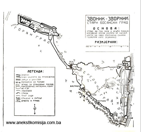
The Upper, Middle and Lower Fort can still be made out in the ruins covering an area of 49,000 m2.
Mediaeval period
Middle Fort, Great Keep. The first tower to be built in the architectural ensemble of the old Zvornik fort was the Great Keep in the central area of the fortifications. Originally it was a typical mediaeval complex with a rectangular keep surrounded by a small bailey. The 60 m long plateau on which the keep was built was surrounded on all sides except to the north by impassable sheer cliffs. The bailey was surrounded by solid walls up to 2.00 m thick. It consisted of two parts: a narrow confined space (the pound), and a wider area where the remains of the walls of some unidentified building or addition were observed (Đ. Mazalić, 1956, p. 250). The entrance to the ward was to the north-west, where the remains of an Ottoman-period gatehouse stand. The gate (measuring 3.0 x 2.30 m) had stone doorjambs and a round-arched lintel. The wall is 1.25 m thick at this point.
The ground plan of the keep consists of two-thirds of a circle facing west, and a secant facing east. The keep was originally much lower in height than now, as shown by walls discovered on the interior. The remaining east wall of the keep is 8.00 m in length. The entrance, which was walled up during later repairs to the keep, was to the south-east, at a height of 4.00 m. The doorframe terminated in a round arch. The keep could have acquired its final form rather later, when the use of firearms began (Đ. Mazalić, 1956, p. 251). A new rectangular entrance was pierced in an adjoining wall, a later addition, at a height of approx. 5.00 m. The masonry technique shows that this extension predates the Ottoman period. The height of the tower, which tapers markedly towards the top, ranges from 18 to 20 m, and the circumference is more than 50 m. During World War II the Germans breached the walls in the lower part of the keep, and the interior is filled with the rubble from the walls. The corridor that was opened up in the lower part of the keep led to a small room the purpose of which is not known.
The keep was built of locally quarried cut stone, set in an abundance of lime mortar, which was also used in places to level the outer and inner faces of the walls. The infill of the wall consists of a mixture of quarry stone and mortar. The upper part of the keep, at a height of 4 to 7 m, is a later extension. Near the top, there is a round-arched window on the north side and another on the east side. Near the windows are four consoles supporting a somewhat projecting extension, and the remains of loopholes that served to protet the entrance to the keep. Below the consoles a horizontal row of metal hoops is set into the wall, similar to cannon barrels, the purpose of which is not known.
Upper Fort. New methods of warfare, the use of firearms and the need to secure the complex more effectively from the north-west prompted the development of the Upper Fort. This part of the fort stands on a plateau surrounded by a high wall. The main enceinte was built near the top of the plateau, where there was probably a tower. To the north-west of the enceinte a transverse moat was excavated. At the easternmost end of the plateau, on the most dominant position, was a bastion or one of the towers referred to in King Matthias' report. The path to the Great Keep ran to the south of this bastion. The path was protected on both sides by a high wall, only parts of which survive to a height of 1.00 m. There were formerly bastions on the approaches to the plateau as well, but the only one that has survived is the one to the south.
This was the form retained by the fort until 1433, when it was taken by despot Đurađ Branković(5).
Ottoman period
Zvornik's importance as a frontier fort grew in the Ottoman period, when the fort was additionally reinforced and enlarged.
Lower Fort. This occupies an area of 7,600 m2. During the early years of Ottoman rule, an octagonal tower was built. The Ottomans used stećak tombstones from a nearby necropolis as building material. The tower was filled in to a height of 8.00 m. At the top is a room with five cannonholes and a fireplace. The round-arched entrance is to the west. To the north of this tower, another gate house was built. The fort was additionally strengthened along the steep cliffs by the construction of various strongholds joined by walls. This enclosed a triangular rocky area, known as Middle and Lower Fort. The area running alongside the river was protected by gate houses. The fort survived in this form until the early 16th century. In his Travelogue, Evliya Çelebi refers to the Careva (Emperor’s) mosque, which stood between the northern gate house and the Great Casemate, where its foundations were found (Đ. Mazalić, 1956, p. 255).
In the 17th and 18th centuries the fortress acquired a more modern appearance. New materials and building techniques were used to build new structures. First to be built were gate houses in The Lower Fort, on the site of the previous gates. Tabija bastions were then built alongside them, and moats 4.00 to 6.00 m. deep were excavated.
The northern entrance to the fort was below the gate house. The tower is a massive, square, two-storey building. The entrance to the fort ran through the ground floor, and the upper storey consisted of a single room with a cannon hole to the north and the entrance to the room – which could be reached only by ladder – to the south. There was a large moat outside the tower, walled with cut stone, 5.00 m deep and 6.00 m wide. By the north side of the moat, near to the top by the drawbridge, a stone fragment dating from the Roman period with a female figure was built into the wall. An ammunitions store was excavated about ten metres from the gate house.
The octagonal tower was joined by walls to the rest of the northern part of the fortress: the gate house, tabija bastion and a small redoubt. The bastion was entered from the road by separate steps leading from inside the fort. A wooden bridge led from the bastion to the redoubt. Separate underground steps led from the road to the bed of the moat. The octagonal tower could be entered from the redoubt.
The southern entrance to The Lower Fort, of which the gate house(6) was walled-up in the late 19th century, led via a drawbridge through the rampart joining the tabija, and then, via a narrow passageway beside the tabija and the great gate house to the fort. The gate house is a square building, the lower part of which is filled in. A stone stairway led from the ground floor to the room on the upper floor. The room had openings for cannon to the east, south and north. A tower was built 20 m from this gate house, right on the cliff; this tower has not survived.
Along the Drina the previously erected rampart, 300 m long, was reinforced, and two small bastions, breastworks, and a large number of loopholes and cannon holes were built into it.
A large casemate was built on the cliff in the Lower Fort, with on it a building measuring 55 x 6.5 m with a barrel vault 4.5 m in height. It was not possible to identify the entrance to this building, which was much damaged when the road was first built in the late 19th century.
The rest of The Lower Fort was used to build houses, military barracks and depots.
Upper Fort. This underwent major repairs in the Ottoman period, following which all that remained of the old walls was the south wall and the foundations of the remaining walls. It covered an area of 8000 m2. A deep moat with almost vertical sides, faced with cut stone, was excavated to the west and north. To the east the moats were closed off with gates (measuring 2.30 x 2.10 m) with round-arched lintels. By the north gate was the main entrance gate house to The Upper Fort, known in the Ottoman period as "Jedrenska".
Some fifty metres from the west moat, yet another running north-south was excavated.
The Great Bastion was built on the site of an earlier mediaeval tower. The ground floor of the original tower was turned into an underground passageway (measuring 10 x 2.5 x 2.5 m), with a barrel vault, which linked the west tabija bastion with the central part of the fortress. A layer of rammed earth 2.25 m thick was laid over the underground passageway. To the north of the passageway, a shelter for the troops was built.
The entrance to the bastion was to the east, where there was also the entrance into two large casemates, the northern measuring 13.40 x 5.30 x 4.00 m and the southern 14.00 x 4.00 x 4.00 m. The entrance to the north casemate was round-arched. The casemates were equipped with several fireplaces to heat the premises.
The exit from the Great Bastion was via an underground passageway (measuring 17.5 x 2 m) and the southern section of the west moat. This passageway was concealed by a smallish building of which no trace now remains. Cannon emplacements were constructed on the west tabija, protected on all sides by earth and vegetation. These were preserved even through subsequent works during the Austro-Hungarian period.
About forty metres from the Great Bastion, the cistern was repaired. Close by yet another bastion was built, reached via the ramparts from the Great Basion. Below this bastion was a shelter (measuring 9.00 x 3.65 m) with a barrel vault, which had a secret exit. To the east of this bastion another similar one was built, linked to the neighbouring tabija (measuring 12.00 x 14.00 m). From this, the path to the Great Keep led via a secret passageway. A relief was built into both the eastern and western part of the tabija. The easternmost part of The Upper Fort was turned into a strong tabija and a smaller bastion, and then provided with additional defences in the form of platforms on the exterior, below the ramparts. Inside The Upper Fort, many residential and office premises and depots were built, along with a small mosque. According to Evliya Çelebi, it was an "old-fashioned mosque, clad with lead and a dome. " Above the entrance door was an inscription (tarih):
"The benefactor, the mighty Conqueror, erected this [mosque] for pious people".
The inscription recording late repairs to the mosque reads:
"Place of worship of dervishes (uššak), the abode of those who prostrate themselves [in prayer] 982" (=1574). (Çelebi, 1979, pp. 482-484).
All these buildings were demolished after 1878.
Middle Fort. The Middle Fort stands on a steep part of the hill between the upper and lower forts, extending from the Great Keep to the cliffs above the Lower Fort, covering an area of 33,000 m2. The Great Tower was retained in the same form, continuing to constitute a major strategic feature of the Zvornik fort. The newly-built towers and bastions in the walls along the steep cliffs had a structural as well as a strategic role, being filled almost to the top with earth. Another two small horseshoe-shaped towers were built in the north rampart, filled with earth to mid-height and left hollow above. They had no loopholes but were probably used as lookout posts. There is another tower on one of the steep cliffs above the Lower Fort, in the shape of an irregular pentagon (measuring 2 x 3.40 x 5.70 x 6 x 7 m). To the east of this a semicircular bastion was built.
A massive buttressed bastion was built in the south rampart of the Middle Fort. Further south another two bastions were built, with a rectangular residential tower (9 x 5 m) between them. This rampart ends in a round tower defending the south gate of the Lower Fort.
A narrow road led through the Middle Fort linking the Great Keep and the northern part of the Lower Fort.
The fort's main powder magazine formerly stood at the centre of the Middle Fort, on a small plateau protected by breastworks.
The material used to build the walls and towers in the Ottoman period was limestone from the neighbourhood of the Zvornik fort.
The Austro-Hungarian period was characterized by interventions mainly consisting of demolishing buildings in the old fort and less of new building. The caravan route in the Lower Fort was no longer adequate for the increased traffic of the day, which led to minor interventions on the north gate, walling up the south gate and breaching the ramparts to allow for the passage of a road. In the Upper Fort, the Austro-Hungarian authorities built a barracks for its own troops, measuring 60.00 x 13.00 m. The building had a basement with a cistern, a ground floor and an upper floor. The entrance was to the east. An exterior staircase led tot he upper floor. There was a bunker to the north, over the entrance to which is a plaque with an inscription, still there today.
At the end of World War I, work continued on widening the road. The passage through the north gate was widened, there was considerable earthing-up inside the fort, the road level was raised, and the south gate was almost completely demolished. These works left the Lower Fort, and the Old Zvornik Fort as a whole, much devastated.
3. Legal status to date
Pursuant to the law, and by Ruling of the National Institute for the Protection of Cultural Monuments of NRBiH no. 86/54 dated 22 October 1954, the Old Fort in Zvornik, Zvornik Municipality, was placed under state protection. By Ruling no. 02-785-3 dated 18 April 1962 it was entered in the Register of immovable cultural monuments.
The architectural ensemble of the Old Zvornik Fort is on the Provisional List of National Monuments under the name Zvornik – Old Fort, under serial no. 773.
The Regional Plan for BiH to 2000 lists it as a Category II monument.
4. Research and conservation and restoration works
In 1964, conservation and restoration works were carried out in the Lower Fort. The riparian rampart, foundations and wall surface were repaired. Conservation and restoration works were carried out on the towers, consisting of replacing the timber roof structures and cladding, using shingles.
In 1965, conservation and restoration works continued on the riparian rampart and walls by the road in the Lower Fort.
In 1979-1981 conservation and restoration works were carried out in two stages: while works were being carried out on the new road(7) in the Lower Fort, and after the road was completed. The previous route was altered so that the road now ran in part through buildings in the Lower Fort. The first stage of the works was on the riparian rampart, casemates and bastions. Major earthworks were carried out, particularly by the riparian rampart where the excavation was 2.5 m in height. Inappropriate additions using concrete blocks from the Austro-Hungarian period were removed, and the walled-up cannon holes were discovered. Excavations were also continued in the tabija bastions by the ramparts. In the north tabija, the remains of floor joists and several loopholes were discovered. In the polygonal tower, the stairway was dug out. During these earthworks, a large quantity of cannonballs were found, mainly stone, of varying calibres. The wooden roof structures and cladding were removed, being dilapidated as a result of poor quality materials and lack of maintenance. The second stage of conservation works carried out at the same time as the road was being built was on the riparian rampart, casement and bastions.
In 1984 works continued on the north gate house and the ramparts by the tower, to the west.
In 1986 conservation and restoration works continued in the Lower Fort: on the north tower, the bastion above the tunnel, and the polygonal tower.
All the works conducted in the Lower Fort were supervised by the Institute for the Protection of Cultural Monuments and Natural Rarities of Bosnia and Herzegovina in Sarajevo. The architectural and spatial design was drawn up by graduate architects Ferhad Mulabegović and Hazim Handžić.
In 1988 minor archaeological excavations were carried out within the walls of the Middle Fort, by Prof. Dr. Đorđe Janković of the Faculty of Philosophy in Belgrade and Mirko Babić MSc, head of the Semberija Museum in Bijeljina. The artefacts found are in the Museum collection in Zvornik.
5. Current condition of the property
An on site inspection conducted on 20 April 2005 ascertained as follows:
Access to the Upper Fort leads past a demolished World War II mausoleum and newly built religious buildings – a church and mausoleum.
The walls and buildings of the Upper Fort are in poor condition as a result of long-term lack of maintenance and physical damage. Parts of some of the buildings, such as the tower by the entrance to the Austrian barracks, the walls by the casemates, the ceiling and north wall in the interior of the Austrian barracks, are badly damaged. The path from the Upper Fort to the Great Keep is barely passable, being very steep and badly overgrown. The walls built on both sides are distorted in places. The maximum height of the walls is 1.00 m.
The Great Keep dominating the entire fort is damaged, especially to the south. Damage is also visible on the tower by the northern, inaccessible section of the ramparts.
The walls and buildings of the Lower Fort are grouped around the road. To build the road "through the face of the wall," parts of the ramparts by the south tower, part of the former south gate, the large cistern near the casemates, and the bastion by the polygonal tower were demolished. This was done using heavy machinery and, in places, explosives, which caused major damage in particular to the part of the fort by the south gate. Conservation and restoration works have been carried out on the buildings and walls, which are now in solid condition.
The casemates are used for the cultivation of mushrooms. By the Drina, along the riparian ramparts, and in particular by the south gate, garbage dumps can be seen.
6. Specific risks to which the property is exposed
No specific risks.
III – CONCLUSION
Applying the Criteria for the adoption of a decision on proclaiming an item of property a national monument (Official Gazette of BiH nos. 33/02 and 15/03), the Commission has enacted the Decision cited above.
The Decision was based on the following criteria:
A. Time frame
B. Historical value
C. Artistic and aesthetic value
C. iv. composition
C. vi. value of construction
D. Clarity
D.i. material evidence of a lesser known historical era
D.ii. evidence of historical change
D. iv. evidence of a particular type, style or regional manner
G. Authenticity
G.i. form and design
G.ii. material and content
G.v. location and setting
H. Rarity and representativity
H.i. unique or rare example of a certain type or style
The following documents form an integral part of this Decision:
o Copy of cadastral plan
o Photodocumentation (photograph of the Museum collection in Zvornik and on site)
o Documentation of the Institute for the Protection of Monuments of the Federal Ministry: initial architectural and town planning design – revitalization of the complex of the Old Zvornik Fort
Bibliography
During the procedure to designate the monument as a national monument of Bosnia and Herzegovina the following works were consulted:
1904. Truhelka, Ćiro, Kraljevski grad Jajce, povijest i znamenitosti. (Royal town of Jajce, history and sites of interest) Sarajevo, 1904.
1916. Thalloczy, Ljudevit, Povijest (banovine, grada i varoši Jajca) (History of the banate, fort and town of Jajce) Zagreb, 1916.
1952. Kreševljaković, Hamdija, Prilozi povijesti bosanskih gradova pod turskom upravom. (Contributions to the history of Bosnian towns under Turkish rule) Contributions to oriental philology and the history of the Yugoslav peoples under Turkish rule II/1951. Sarajevo, 1952, 119-184.
1953. Kreševljaković, Hamdija, Stari bosanski gradovi (Old Bosnian towns) Naše starine I, Sarajevo, 1953, 7-45.
1955. Dinić, Mihailo, Za istoriju rudarstva u srednjovekovnoj Srbiji i Bosni (For the history of mining in mediaeval Serbia and Bosnia) Part I, Belgrade, 1955.
1955. Mazalić, Đoko, Zvornik (Zvonik) stari grad na Drini (Zvornik [Zvonik] old fort on the Drina) Jnl of the National Museum of Bosnia and Herzegovina n.s. vol. X, Sarajevo, 1955, 73-116.
1956. Mazalić, Đoko, Zvornik (Zvonik) stari grad na Drini. (Kraj) (Zvornik [Zvonik] old fort on the Drina [concluded]). Jnl of the National Museum of Bosnia and Herzegovina n.s. sv. XI, Sarajevo, 1956, 97-118.
1961. Kovačević-Kojić, Desanska, Zvornik u srednjem vijeku (Zvornik in mediaval times) Annual of the Society of Historians of BiH XVI, Sarajevo, 1961, 19-35.
1964. Ćirković, Simo, Istorija srednjovekovne bosanske države (History of the mediaeval Bosnian state) Belgrade, 964.
1970. Handžić, Adem, Zvornik u drugoj polovini XV i XVI vijeka (Zvornik in the second half of the 15th and the 16th centuries) Annual of the Society of Historians of BiH XVIII, Sarajevo, 1970, 141-196.
1973. Kujundžić, Juraj, Crkva Svete Marije u Zvorniku (Church of St Mary in Zvornik) Dobri pastir XXIII, Sarajevo, 203-210.
1977. Anđelić, Pavao, O usorskim vojvodama i političkom statusu Usore u srednjem vijeku. (On Usora's military leaders and the political status of Usora in mediaeval times) Contributions to the Institute for History in Sarajevo no. 13, vol XIII, Sarajevo, 1977, 17-45.
1977. Anđelić, Pavao, Ubikacija oblasti Trebotića i teritorijalno – politička organizacija bosanskog Podrinja u srednjem vijeku (Location of Trebotića district and the territorial and political organization of the Bosnian Drina valley in mediaeval times) Jnl of the National Museum of Bosnia and Herzegovina (A), n.s. sv. XXX-XXXI/1975-1976, Sarajevo, 1977, 243-268.
1978. Kovačević-Kojić, Desanka, Gradska naselja srednjovjekovne bosanske države (Urban settlements of the mediaeval Bosnian state) Sarajevo, 1978.
1979. Çelebi, Evliya, Putopis (Travelogue) ed. Hazim Šabanović, IRO Veselin Masleša, Sarajevo, 1979.
1981. Bojanovski, Ivo, Prilozi za topografiju rimskih i predrimskih komunikacija i naselja u rimskoj provinciji Dalmaciji, III – Prilog proučavanju antičkih naselja i komunikacija u istočnoj Bosni (Contributions to the topography of Roman and pre-Roman roads and settlements in the Roman province of Dalmatia, III – Contributions to the study of antique settlements and communications in eastern Bosnia) Annual of the Centre for Balkan Studies, bk 17. Academy of Science and the Arts of Bosnia and Herzegovina, bk XIX, Sarajevo, 1981, 125-198.
1991. Kreševljaković, Hamdija, Kapetanije u Bosni i Hercegovini (Captaincies in BiH) Selected Works I, Veselin Masleša, Sarajevo, 1991.
(1) From Arheološkog leksikona BiH (Archaeological Lexicon of BiH), vol 2, region 6, Sarajevo, 1988, 88-96.
(2) From documentation of the Institute for the Protection of Monuments of the Federal Ministry of Culture and Sport, Kreševljaković Muhamed, 1986, Istorijska osnova (Historical background)
(3) It is not clear from historical sources whether, and if so when, the aristocratic family of the Zlatonosović’s included Zvornik and environs in their holdings (cf. Anđelić, 1977 and 1977.a and Handžić, 1975, p. 24).
(4) This reference to the formation of the Zvornik kadiluk is taken from Handžić, 1975, 49-50 with the author’s reference to the state of knowledge of early Ottoman sources at the time when Šabanović wrote Bosanski pašaluk, in 1959.
(5) It was probably despot Đurađ who carried out the major repairs on the Great Keep (Đ. Mazalić, 1956, 256).
(6) The used to be a tarih over the gate house, but it has long since disappeared. The place where it used to be can still be clearly seen. (Đ. Mazalić, 1956. 259).
(7) The volume of traffic through the Lower Fort was the subject of a study on the route to be taken by the road, with several variants. The Institute for the Protection of the Cultural, Historical and Natural Heritage of BiH (the heritage protection authority) advocated the "tunnel variant" for the route of the road, which would have caused the least possible damage to the Lower Fort. A design project was drawn up, but unfortunately never implement. The variant that led "through the wall face" was adopted, being financially far more acceptable (Institute for the Protection of Cultural Monuments and Natural Raririties of Bosnia and Herzegovina, Sarajevo, 1986.)
|