Status of monument -> National monument
Published in the “Official Gazette of BiH” no. 20/08.
Pursuant to Article V para. 4 Annex 8 of the General Framework Agreement for Peace in Bosnia and Herzegovina and Article 39 para. 1 of the Rules of Procedure of the Commission to Preserve National Monuments, at a session held from 15 to 21 March 2005 the Commission adopted a
D E C I S I O N
I
The architectural ensemble of the old Vratnik Fort in Sarajevo is hereby designated as a National Monument of Bosnia and Herzegovina (hereinafter: the National Monument).
The National Monument consists of the remains of the walls of the old fort and bastions, gate houses and gates, and movable heritage items found on the archaeological site and housed in the Cantonal Institute for the Protection of the Cultural, Historical and Natural Heritage of Sarajevo and the National Museum of Bosnia and Herzegovina in Sarajevo.
The National Monument is located on a site designated as cadastral plot no. 3, Land Register entry no. XC/21, c.p. no. 4, Land Register entry no. LXXXIX/66, c.p. no. 5, Land Register entry no. XC/53, c.p. no. 60, Land Register entry no. LXXXVII/48, c.p. no. 63, Land Register entry no. XC/57, c.p. no. 21, Land Register entry no. XCV/43, c.p. no. 23, Land Register entry no. XXXIV/45, c.p. no. 38, Land Register entry no. XCV/74, cadastral municipality Sarajevo, c.p. no. 1291/1, title deed no. 69, c.m. Koševo, c.p. no. 3, Land Register entry no. L~XXXVII/48, and c.p. no. 61, Land Register entry no. LXXXVI/123, and c.p. no. 102, Land Register entry no. LXXXVI/123, c.m. Vasin Han, Federation of Bosnia and Herzegovina, Bosnia and Herzegovina.
The provisions relating to protection measures set forth by the Law on the Implementation of the Decisions of the Commission to Preserve National Monuments, established pursuant to Annex 8 of the General Framework Agreement for Peace in Bosnia and Herzegovina (Official Gazette of the Federation of BiH nos. 2/02, 27/02 and 6/04) shall apply to the National Monument.
II
The Government of the Federation of Bosnia and Herzegovina (hereinafter: the Government of the Federation) shall be responsible for ensuring and providing the legal, scientific, technical, administrative and financial measures necessary to protect, conserve, and display the National Monument.
The Commission to Preserve National Monuments (hereinafter: the Commission) shall determine the technical requirements and secure the funds for preparing and setting up signboards with the basic data on the monument and the Decision to proclaim the property a National Monument.
III
To ensure the on-going protection of the National Monument, the following protection measures are hereby stipulated, which shall apply to the area defined in Clause I para. 3 of this Decision.
- all works are prohibited other than research and conservation and restoration works, including those designed to display the monument, with the approval of the Federal Ministry responsible for regional planning and under the expert supervision of the heritage protection authority of the Federation of Bosnia and Herzegovina;
- the site of the monument shall be open and accessible to the public and may be used for educational and cultural purposes, subject to all interventions being temporary, removable and of a kind that will not alter the structure and original expression of the National Monument;
- the dumping of waste is prohibited.
To ensure the on-going protection of the National Monument, the following works shall be carried out:
- clearing the ramparts of the fort, the walls of the towers, other areas and the surroundings of self-sown vegetation and dirt caused by weathering that represents a danger to the structure of the monument;
- structural repairs to the towers and ramparts where cracks have appeared that threaten to bring about the collapse of the entire structure;
- during structural repair, conservation and restoration works, original materials and binders shall be used wherever possible;
- during repair works, the existing stone blocks shall be used;
- the crown of the walls should be of natural materials (stone capping or treatment with hydraulic mortar);
- major cracks must be filled with a compound of small pieces of stone and hydraulic lime mortar;
- all structures that do not conform to the principles of reconstruction shall be removed and conservation and restoration works shall be repeated;
- archaeological investigations on the Bijela tabija (White Bastion) and conservation works on any remains discovered shall be continued;
- the landslide in the immediate vicinity of the fort shall be made good.
- a programme to display the National Monument shall be drawn up and implemented;
IV
The removal of the movable heritage items referred to in Clause 1 para. 3 of this Decision (hereinafter: the movable heritage) from Bosnia and Herzegovina is prohibited.
By way of exception to the provisions of paragraph 1 of this Clause, the temporary removal from Bosnia and Herzegovina of the movable heritage for the purposes of display or conservation shall be permitted if it is established that conservation works cannot be carried out in Bosnia and Herzegovina.
Permission for the temporary removal of the movable heritage from Bosnia and Herzegovina under the conditions stipulated in the preceding paragraph shall be issued by the Commission to Preserve National Monuments, if it is determined beyond doubt that it will not jeopardize the items in any way.
In granting permission for the temporary removal of the movable heritage, the Commission shall stipulate all the conditions under which the removal may take place, the date by which the items shall be returned to the country, and the responsibility of individual authorities and institutions for ensuring that these conditions are met, and shall notify the Government of the Federation of Bosnia and Herzegovina, the relevant security service, the customs authority of Bosnia and Herzegovina, and the general public accordingly.
V
All executive and area development planning acts not in accordance with the provisions of this Decision are hereby revoked.
VI
Everyone, and in particular the competent authorities of the Federation of Bosnia and Herzegovina, the Canton, and urban and municipal authorities, shall refrain from any action that might damage the National Monument or jeopardize the preservation and rehabilitation thereof.
VII
The Government of the Federation, the Federal Ministry responsible for regional planning, the Federation heritage protection authority, and the Municipal Authorities in charge of urban planning and land registry affairs, shall be notified of this Decision in order to carry out the measures stipulated in Articles II to VI of this Decision, and the Authorized Municipal Court shall be notified for the purposes of registration in the Land Register.
VIII
The elucidation and accompanying documentation form an integral part of this Decision, which may be viewed by interested parties on the premises or by accessing the website of the Commission (http://www.aneks8komisija.com.ba)
IX
On the date of adoption of this Decision, the National Monument shall be deleted from the Provisional List of National Monuments of Bosnia and Herzegovina (Official Gazette of BiH no. 33/02, Official Gazette of Republika Srpska no. 79/02, Official Gazette of the Federation of BiH no. 59/02, and Official Gazette of Brčko District BiH no. 4/03), where it featured under serial nos.: 537, 547, 549, 550, 564, 565.
X
Pursuant to Art. V para 4 Annex 8 of the General Framework Agreement for Peace in Bosnia and Herzegovina, decisions of the Commission are final.
XI
This Decision shall enter into force on the date of its adoption and shall be published in the Official Gazette of BiH.
This Decision has been adopted by the following members of the Commission: Zeynep Ahunbay, Amra Hadžimuhamedović, Dubravko Lovrenović, Ljiljana Ševo and Tina Wik.
No: 05.1-2-269/04-6
16 March 2005
Sarajevo
Chair of the Commission
Amra Hadžimuhamedović
E l u c i d a t i o n
I – INTRODUCTION
Pursuant to Article 2, paragraph 1 of the Law on the Implementation of the Decisions of the Commission to Preserve National Monuments, established pursuant to Annex 8 of the General Framework Agreement for Peace in Bosnia and Herzegovina, a “National Monument” is an item of public property proclaimed by the Commission to Preserve National Monuments to be a National Monument pursuant to Articles V and VI of Annex 8 of the General Framework Agreement for Peace in Bosnia and Herzegovina and property entered on the Provisional List of National Monuments of Bosnia and Herzegovina (Official Gazette of BiH no. 33/02) until the Commission reaches a final decision on its status, as to which there is no time limit and regardless of whether a petition for the property in question has been submitted or not.
The Commission to Preserve National Monuments adopted a decision to add the architectural ensemble of the old Vratnik fort to the Provisional List of National Monuments of Bosnia and Herzegovina under the title City Walls of the Mediaeval Fort of Vratnik under serial no. 547, Sarajevo, Bijela tabija (White Bastion), serial no. 537, Sarajevo, gate house at Ploča, serial no. 459, Sarajevo, gate house at Širokac, serial no. 550, Sarajevo, Višegrad gate house, serial no. 564, Sarajevo, Žuta tabija (Yellow Bastion) (Jekovačka), serial no. 565.
Pursuant to the provisions of the law, the Commission proceeded to carry out the procedure for reaching a final decision to designate the Property as a National Monument, pursuant to Article V of Annex 8 and Article 35 of the Rules of Procedure of the Commission to Preserve National Monuments.
II – PROCEDURE PRIOR TO DECISION
In the procedure preceding the adoption of a final decision to proclaim the property a national monument, the following documentation was inspected:
- Documentation on the location and current owner and user of the property (copy of cadastral plan and copy of land registry entry)
- Data on the current condition and use of the property, including a description and photographs, data of war damage, data on restoration or other works on the property, etc.
- Historical, architectural and other documentary material on the property, as set out in the bibliography forming part of this Decision.
The findings based on the review of the above documentation and the condition of the site are as follows:
1. Details of the property
Location
The old Vratnik fort, the area of which was completed in the Ottoman period between 1729 and 1816, is located at the eastern end of the urban centre of Sarajevo. The main point of the fort is Bijela tabija (White Bastion), built on the south-eastern rocky prominence of the upper hilly area. The boundary here is the rocky cliffs of the Miljacka and the entrance to the valley of the mid course of the river Miljacka, Sarajevo plain and the basin of the upper course of the river Bosna, constituting a transition from one geographical region to another. The entire fort is therefore called Vratnik.
The view from the White Bastion extends eastwards to the old fort in Bulozi (3 hours' walk), southwards to the entire northern flank of Mt. Trebević and the Miljacka gorge, westwards to Sarajevo plain and the entire hilly regions around it, and eastwards to Faletići and Hreša. Two trade and military routes passed this way: the first via Vratnik, Hreša and Mokro to eastern and north-eastern Bosnia, and the second along the Miljacka valley to Kozja ćuprija (Goat Bridge) and on to Pale and the upper Drina valley. The first mediaeval castle to be built was extended by a bastion in the 18th century, and finally, the fort was built in the Austro-Hungarian period. The rest of the fortifications comple in Vratnik extends along the slopes to the north and east of the White Bastion. One of the main mediaeval and Ottoman roads ran through Vratnik, alongside the White Bastion, on the site of the Višegrad Gate – the Bioski road, which led from Kovači, via Širokac, Vratnik mejdan and Carina to the Višegrad Gate and on to the east.
Historical information
Mediaeval period
During the late mediaeval period, the territory of the large early mediaeval župa (county) of Vrhbosna was split up into several smaller župas (districts or knežija). The disposition of mediaeval forts around Sarajevo is evidence of the intensive development of socio-political relations that led to the formation of smaller counties. The late mediaeval župa of Vrhbosna encompassed the territory from the Bistrica river and the confluence of the Paočica and Mokranjska Miljacka to the east to Binježevi to the west, the river Vogošća to the north, and via Zoranovići and Kijevo, along the Kasindolski brook on the slopes of Jahorina to the south. Here two natural entities can be distinguished: the Sarajevo plain, and the Miljacka valley, where the centre of the city of Sarajevo lies with its surrounding hillsides to the north and south. Three late mediaeval forts were built there: Teferić above Krupac on the south-eastern edge of the Sarajevo plain, the old fort in Bulozi, and a fort on the site of the present-day White Bastion in Vratnik. At some time in the 13th century the centre of gravity shifted from the Sarajevo plain, where there are early mediaeval monuments, to the area of the present-day heart of the city of Sarajevo (Fekeža, 1997,19-34).
On the site of the present-day White Bastion in Vratnik was a fortress below which an outlying settlement grew up, in which Ottoman sources of the second half of the 15th century record 8 Dubrovnik households (Bejtić, 1979, 107-148). Mediaeval sources dealing with the area of the present-day city centre refer to the Utornik («Tuesday») market, and early Ottoman sources use the toponym «Stara varoš» (Old Town). The earliest census of the Bosnian sandžak refers to Stara Varoš as Staro trgovište (old market town). A third name, encountered in Dubrovnik sources, is Vrhbosanje, found as early as the 13th century (Ančić, 2000, 53, 56, 58-59). There is no consensus as yet on the location of the sites referred to as the Utornik and Stara varoš markets, or on that of Vrhbosanje (Vrhbosna) (Šabanović, 1951, 20; idem 1960, 93; Kreševljaković, 1956, 13; Kovačević-Kojić, 1978, 77; Bejtić, 1979, 145; Ančić, 2000, 46-80). The surrounding villages of Brodac, known from the vakuf name (deed of endowment) (1462) of Isa beg Isaković, Koševo, Radilovići, Bilave (Bjelave) on the slopes by the right bank of the Miljacka, and Bistrik, Hrid, Komatin, and Žagrići on the northern flanks of Trebević, already existed in the mediaeval period, as evidenced by an early Ottoman source – a 1455 Defter (Bejtić, 1973, 29-30).
The roads that took shape in the urban fabric in the Ottoman period were already in existence in the mediaeval period, if not earlier. The main and transit roads were the present-day streets of Za beglukom (formerly Širokača), Vratnik mejdan (formerly the Širokac or Bioski road) and, in the valley, Branilaca Sarajevo and Zelenih beretki, Sarači, Ferhadija and Marshal Tito streets (Bejtić, 1973, 30).
In the mediaeval period, there was a small fort on the site of the White Bastion, referred to and described by travellers passing through Sarajevo in the 16th century. Early Ottoman sources, too, refer indirectly to the existence of a fortress in Vratnik. In his admission lecture to the Academy of Science of Bosnia and Herzegovina in 1977, Bejtić proposed the hypothesis, supported by a range of arguments, that the early Ottoman sources referring to the Hodidid fortress, together with the activities of the first Ottoman authorities in the Vrhbosna župa from 1435 on, refer to a fort in Vratnik, built in the late 14th century (Bejtić, 1979, 107-148).
Ottoman period
During the 16th century, when the Ottoman empire was expanding, and the borders of the empire were far from Sarajevo, there was no need to built a fortress in the city. Although there were growing signs of crisis during the 17th century, Sarajevo's agas (military commanders), who were at the height of their power, opposed the idea of building a fort in Sarajevo, fearing they would lose some of their rights and privileges. In effect, until the campaign by Prince Eugene of Savoy in 1697, there was no need to build any new fortress in the city. These attacks revealed that the fort could hold no more than 150 to 200 men, and provide refuge for about 400 civilians. Following the Treaty of Karlowitz in 1699, it became clear that there was a real danger to the city. But it was only after the Treaty of Passarowitz, in 1718, that Sarajevo's ulema (religious scholars) also perceived the need to build a larger fortress. In 1715 there were a mere 58 janissaries in the fort (Skarić, 1985, 134). Representatives of the citizenry, and the kadi, aware of new threat to the city, had already issued a document on 20 October 1709 calling for thorough repairs to the fortress. It was noted that in 1705 a list of damage to the fortress had been drawn up, including dilapidated ramparts, towers and water pipes, the dizdar's (fortress commander's) house, and the cannon platforms on three towers, with the exception of the south-eastern tower; in 1709 it was added that the džebhana (ammunition depot) was also in a completely ruinous state (Bejtić, 1979, 127). Another significant reference is to the water pipes, installed by the Bosnian sandžak-beg and legator Skender-paša in the late 15th century. These supplied water by gravity feed from the bed of a branch of the Mošćanica, running through Vratnik to bring water to the Čaršija. In another document dated 16 December 1709 the people of Sarajevo wrote to the Port that they had no fortifications or palanka (permanent camp) in which at least 10,000 souls could take refuge.
However, it is not known exactly when the complex on the site of the White Bastion was built. Bejtić is of the view that with the erection of a bastion on the site, a džebhana (ammunitions depot) and possibly some other structures, the old mediaeval fortress was encircled by a new Ottoman period complex and thus became an „Ičkala“, an inner fortress. He specifically notes that this is not a complex of part of the 18th century Vratnik fort, but the entire complex of the fortress referred to in the mid 16th century (Bejtić, 1973, 189, 302). There is indirect reference to this in the details of the construction of the Vratnik bastions, towers and ramparts between 1729 and 1739,where there is no reference to the White Bastion (Traljić, 1937, 17; Skarić, 1985, 135). In his later work, Bejtić writes that the White Bastion was built, as were three others (he does not say which) between 1729 and 1739 (Bejtić, 1979, 117). Kreševljaković notes that the mediaeval fort was extended and that at that time, the fourth decade of the 18th century, „those three towers too“ were built, though he does not say which (Kreševljaković, 1953, 16).
The building works were begun during the governorship of Gazi Ahmed Paša Rustempašić Skopljak, who was appointed governor of Bosnian in 1727. Ahmed paša at once embarked on preparations to extend the existing fortress. He decided to build ramparts around 450 houses and to leave sufficient vacant land for another 450. The plan was for the wall to be an hour's walk long, 2 arshins wide, and 10 arshins high, and to build four bastions in the ramparts. Work began in 1729. In June of that year he requested the people of Dubrovnik to send him 5 lagumdžija (dynamiters, blasters) and 5 čerahora (fortress-builders). He appointed his son Rustem beg as works supervisor (Skarić, 1985, 135). The four bastions on which work began at this time are:
The bastion in Jekovac, known as Ahmed paša's bastion or, as the local people call it, Žuta tabija (Yellow Bastion); the Strošićka tabija named after Ahmed paša's father the Rustempašina tabija (Rustem Pasha's bastion); the bastion on Ravne bakije named after Sultan Ahmed, but called Arab Bastion by the locals; and the bastion on Zmajevac on the summit of Čebedžije, named the Ibrahim paša Arnaut bastion but called Arnaut Bastion or the Bastion below the Gate by the locals (Traljić, 1937, 17-18; Skarić, 1985, 135).
When Ahmed paša was posted away from Bosnia in 1730, building was suspended or proceeded more slowly. It was continued by Vizier Hećim oglu Ali paša, victor of the battle of Banja Luka in 1739 when he defeated Prince Hindenburghausen, who spent the winter in Sarajevo that year. He was assisted in the building works by the ulama and the people. One of the legends concerning the construction of the Vratnik ramparts recounts that Hećim paša, noting that Sarajevo had so many burial grounds, ordered all the stone to be taken from them and used to build the ramparts.
All three bastions, Vratnik, Širokac and Ploča, were complete by 1739. There were two dungeons in the fort, as can be seen from documents dating from 1774 andd 1798 (Traljić, 1937, 15; Bejtić, 1979, 133). One was in the old fortress on the White Baston, and the other probably in Čebedžije, after the construction of the new ramparts (Traljić, 1937, 19).
Until 1729 the dizdars of the Vratnik fort resided in the fortress. After work began at that time on building ramparts encircling a greater extent than the fortress on the White Bastion, they took up residence in the mahalas (residential quarters) within the Vratnik fort.
The 18th century ramparts and bastions were built at speed, and the magazine and ammunition were destroyed by lightning; repairs thus had to be carried out on several occasions: 1771, 1777, 1782, 1786, 1796-1797, and 1798 (Traljić, 1937, 13-16; Kreševljaković, 1953, 16).
Later another four bastions were built. This was probably in 1816, when repairs to the old ramparts also began. Chaumette de Fossés, who had stayed in Sarajevo ten years earlier, described Sarajevo's defense system, referring to three small square forts surrounded by four towers built to the old system of fortification. These were joined by walls two and a half to three feet thick and 14 to 15 feet high. A number of civilian houses also lay within the walls. This was known as a fort or castel, in which the tallest keep stood on a hillock in an advantageous position (Traljić, 1937, 16).
The fort was extensively repaired and extended in 1816, under the supervision of the state neimar (architect, civil engineer) Halil-efendija (Skarić, 1985, 182). There is a description of the fort, which appears to date from the period following the construction of the entire fortifications system (1816). According to this description, the fortress was very extensive, with walls 2 fathoms thick, but no fosse. It had 12 batteries and the same number of towers, on which were 80 medium-calibre cannon. There was a janissary company in the fort, commanded by an aga and numbering 12,000 men. There were 12,000 houses inside the fort (Bodenstein, 1908, 95). This description agreed with a plan of the fort in Vratnik drawn in 1881. Traljić writes that in 1841 about 2,000 people were living within the ramparts of the Vratnik fort, in 360 houses; by 1937 this has risen to a population of 6,000 in almost 1,000 houses (Traljić, 1937, 31). Thus the Vratnik fort, covering an area of 495.565 m2, took in 11 mahalas (residential quarters) and part of a 12th which, to judge from the time when their mosques were built, came into being in the 16th century (Traljić, 1937, 8-12,17). These mahalas are:
- Gerdani el-Hadži Husein Husejn mehallesi-Mahala Strošići, which includes the oldest mosque in Vratnik, built in 1473. (Traljić, 1937, 33-34; Bejtić, 1973, 341);
- Topal Einehan mehallesi. Founded before 1528, this was later known as Lubina mahala. Here the Topal zade hadži Inhanage (Einehana) mosque, known as the Lubina, was built between 1528 and 1557. (Traljić, 1937, 34-36; Bejtić, 1973, 234);
- Divani katib mehallesi- hadži Hajdara – White Mosque, built before 1545. (Traljić, 1937, 36-40; Bejtić, 1973, 168, 226, 262);
- Sinan vojvoda mehallesi mosque, known as Mala džamija (small mosque) or Pod orahom, built before 1552 by the wife of Duke Sinanudin Jusuf. (Traljić, 1937, 40 -43; Bejtić, 1973);
- Neš-zade el Hadži Husein mehallesi in Dol. (Traljić, 1937, 47; Bejtić, 1973, 141);
- Hasan Iplidžik mehallesi, known to the locals as Širokac. The Iplidžik Sinan mosque was built before 1565. (Traljić, 1937, 47; Bejtić, 1973, 199)
- Kadi Ahmed efendi mehallesi – Pod Topovima (under the cannon), where the mosque of Ahmed efendija was built in Kršilovcu after 1565. This mosque is known as “Pod Ičkalom”, or “Pod gradom” (below the fort). (Traljić, 1937, 47; Bejtić, 189);
- Havadže-zade el Hadži Mustafa mehallesi – where the mosque Na Musluku was built in 1587. (Traljić, 1937, 43- 44; Bejtić, 1973, 239);
- Kasap-zade el hadži Ibrahim mehallesi in Carina, actually in Ispod oraha street, built after 1565. (Traljić, 1937, 44; Skarić, 1937, 76; Bejtić, 1973, 16, 189-190);
- Sagr el-Hadži Mahmud mehallesi in Hendek, where a mosque was built after 1565. (Traljić, 1937, 47; Skarić, 1937, 76; Bejtić, 1973, 316);
- Mokro–zade el-Hadži Sinan mehallesi in Čebedžije, which began to take shape in the late 16th century. The mosque of the same name was built on the highest hillock within the Vratnik fort. (Traljić, 1937, 46, Bejtić, 1973, 131-132);
- Part of Shaikh Muslihudin mehallesi in Ploča. (Traljić, 1937, 30; Bejtić, 1973, 16, 301) (Traljić, 1937, 30).
In the 19th century, repairs to the old fort were carried out in 1805, 1813, 1816 and 1835.
In February 1824 a commission charged with inspecting the fort and weaponry found that the fort contained 24 small and large cannon, 12 kubura (pistols with a gunpowder charge), 250 shells, 19,635 small and large calibre cannon shells, 774 rifles, 670 sabres, 5,650 oke (one oke = 3 pounds) of gunpowder, and 53 chests of powder-charges (Skarić, 1985, 182).
After the abolition of the kapetanija (captaincies), in 1836 all the forts in Bosnia were inspected. A large quantity of different types of firearms, ammunition, maintenance tools and other military equipment was found in Sarajevo (Traljić, 1937, 24).
Austro-Hungarian period
Austrian troops entered Sarajevo on 19 August 1878. The army advanced from Pašino hill towards the northern bastion (in Ravne bakije) of the Sarajevo fort. Some 550 to 600 defenders were assembled around this bastion, with two cannon. The Yellow Bastion was hit by Austrian artillery. The Sarajevo fort held out on that day, although its cannon were put out of action, until 12.30, when the Austrians breached its defences. Fighting continued around the Yellow Bastion at around 14.00 h. At about 14.30 the firing stopped, and Sarajevo was occupied (Skarić, 1985, 307-309).
In 1889 the Austrian authorities, too, carried out repairs to the fort (Kreševljaković, 1953, 16). In 1886 work began on a barracks on the site where the Jajce barracks would later stand. This complex was entirely different from the Eugene of Savoy barracks, which was built in 1913 and 1914. It acquired the name Jajce barracks in 1915 after the town of Jajce, whence the military hospital moved into this barracks that year (Bejtić, 1973, 301).
After 1945, the Yugoslav National Army built a barracks between the bastion on Ravne bakije and the Zmajevac bastion; this barracks is now being used by the Army of Bosnia and Herzegovina.
2. Description of the property
Archaeological investigations have shown that this is a multistratum archaeological site and architectural fortifications complex dating from several different periods.
The mediaeval fort stood on the site of the White Bastion, at the extreme end of a high rocky eminence above the Miljacka gorge and Darive. Access was from the north, from the Višegrad gate.
There are no mediaeval written sources on this fort, but descriptions by various travellers and spies who passed through Sarajevo in the 16th and 17th centuries survive. The first to record the existence of a fortress in Vratnik was written by Catarino Zeno in 1550, who merely noted that there was a fort above Sarajevo.
The earliest description of the original fortress in Vratnik is from a report on his travels in Bosnia by Andrija Grgičević of Split, which he sent to the German Emperor in 1626. He described an old and not very large fort with four very small towers. It contained one or two medium-calibre cannon. An aga, who also served as dizdar or fortress commander, lived in the fort.
Abbot Pavle Rovinjanin, who passed through Sarajevo in 1640, noted “some small fort, of insignificant size”.
Giovanni Morosini, escort of the Venetian envoy en route to Istanbul in 1672, wrote that a square fortress was being built on the same route (as the varoš in Sarajevo), which had four towers and served to defend the varoš.
Evliya Çelebi, who stayed in Sarajevo in 1660 with Melek Ahmed-paša, provided the (relatively) fullest description of the fortress. In March 1659 Melek Ahmed paša became Bosnian beglerbeg (governor), and governed the country until November 1660. According to Çelebi, he renovated and repaired the fort in Vratnik. Çelebi described it as a small stone-built fort with a circumference of 400 feet, bult before the Ottomans conquered the area. It had a small fosse to the north, while to the south-east, down to the Miljacka, the fort was protected by the natural defences of the gorge, as deep as “two minarets". The fortress could not be harmed from this side, although it was in a dilapidated state. He noted a number of other details: the fort had a square iron gate facing east; it was in a ruinous state on the Mokro road side and from the elevation on the far side of Degirmenlija (above the Višegrad gate) and that it could not withstand cannon fire. Çelebi referred to the Ebul-Feth Mehmed-han (Sultan Mehmed Khan al-Fatih, 1451-1481) mosque within the fort, saying that of the many mosques in Sarajevo it was the “first up in the fort”, and that it was pleasing, small and modest. This mosque stood within the fort until 1811 (Çelebi, 101-103, 106, n. 68). Within the ramparts, too, was the imam's house, two muezzins and two buglers, a grain store, and some military quarters.
Alija Bejtić tried to reconstruct the architectural features of the original fortress in Vratnik from these descriptions and the sketches made by Eugene of Savoy's staff officers and other spies in the 17th century, which are in the war archives in Vienna. The fort was built in the pre firearms age and probably dated from the late 14th century. The site was later exposed to cannon fire from all sides from very close quarters. The fort was rectangular in ground plan, with four square towers at the corners. Calculating from Çelebi’s description the fort was about 300 m in circumference. There are forts of this layout in Croatia, Slavonia and Srijem, and even one on the Danube (the Haram fort, the Hungarian Uj palanka, Turkish Yeni palanka or New Camp) on the Romanian-Serbian border. In France, such forts, square rather than rectangular in ground plan, were being built from the 14th century. Parts of inner Croatia, Slavonia and Srijem were under Hungarian rule, and Hungary was also exerting considerable pressure as well as influence in Bosnia. Bejtić concludes that it was „for this very reason that mediaeval Hungarian architecture in the Gothic style was the basis for the ground plan and configuration of the fort in Vratnik“ (Bejtić, 1979, 122).
Bejtić assumed that the old mediaeval fort remained in existence right up to 1878, when the new Austrian fort was built on the site. One of the ramparts of the new fort appears to incorporate the last visible remains of the old fort (Bejtić,1979, 117).
The Vratnik ramparts surround an area of 495.596 m2, of irregular shape. The walls are about 2 m thick. Five bastions were built as part of the ramparts:
- the White Bastion
- the Strošićka Bastion
- the Yellow or Jekovačka Bastion
- the bastion on Ravne bakije
- the bastion on Zmajevac
and three gate houses:
- the Višegrad gate house
- the gate house in Ploča
- the gate house in Širokac, together with five gates and a number of posterns.
White Bastion
This is the forwardmost point of the ramparts of the old Vratnik fort, dominating the natural entry to the town from the east. The site where the fort stands is completely inaccessible from the south and offers an outstanding outlook.
Trial archaeological investigations in 1991 revealed that the oldest part of the tower was built in the mediaeval period, in the late 14th or early 15th century, and then added to during the Ottoman and Austro-Hungarian periods. The original fortress was rectangular in plan, measuring 75 x 50 m, with four square towers at the corners and a fifth above the entrance gate. After the arrival of the Ottomans, a garrison and garrison commander were stationed in the fort. Later a defense complex was erected consisting of an outer rampart, one bastion and an entrance tower, into which the small mediaeval fortress was incorporated. The walls of this complex have survived to a height of about 7.0 m. The walls are 1.40 m thick at their thickest. The entrance to the bastion was from the north. It was guarded by a small tower measuring 6.0 x 6.0 m. Inside the bastion, by the north and west wall, were rooms to house the garrison, and magazines. Excavations uncovered, at a depth of 0.35 m, the remains of an octagonal structure, its sides measuring 8.0 m, built during the Ottoman period.(1)
Apertures for loopholes are visible on the exterior stone walls. After the Austro-Hungarians took power, the interior was demolished and the central area levelled. An architectural complex consisting of a larger number of rooms was added, which is still recognizable today. The masonry consisted of large, regular-cut limestone blocks, with the window frames of sandstone.
To the north of the entrance an outbuilding of rectangular plan, measuring 15.0 x 7.0 m, was erected; this was used as an ammunitions depot.
The Strošićka Bastion is in the north-west section of the ramparts. It is a trapezium in plan, with an area of 367 m2. The two parallel sides measure 25 and 14 m, and the other two sides 18 and 21 m. It was built on steep terrain, where the walls survive to a height of 3.0 m on the north-east side and 8.0 m on the north-west.
The Yellow Bastion was built of rough-cut stone. It has a polygonal ground plan with seven outer sides each 10 m in length, and the eighth, facing north, 27,5 m long. The walls are 35 cm thick and survive to a height of 7.5 m. To the north is a stairway and a building for troops, and to the south-west a small Muslim burial ground. In 1878 the part of the rampart extending eastwards from the bastion was cut off. Until 1946 there was a gate to the west; this was demolished to allow for the road to be widened. The bastion was in use during the Austro-Hungarian period and underwent repairs in 1883 and1903.
The bastion on Ravne bakije, like that bastion on Zmajevac, is in the extreme northern parts of the ramparts, where access is restricted.
Gate Houses
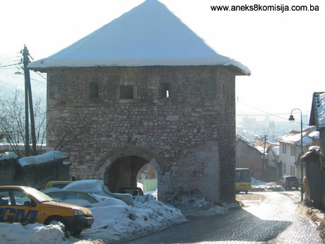
The gate house in Ploča is an old-style tower used for defensive purposes during wartime and housing guards during peacetime. It forms part of the ramparts of the Vratnik fort. It was built of rough-cut limestone and tufa. It is square in ground plan, with the sides measuring 10.15 m. The passageway through the centre is barrel-vaulted. The entrance gate is set back into the passageway. In the walls to either side of the passageway in front of the gate is a niche 0.70 cm deep. Within the passageway are a further two niches, 1.20 cm deep. There is a room in the upper part of the tower, formerly reached via a wooden staircase. The gate house has a timber roof structure, hipped roof and shingle cladding.
The Višegrad gate house forms part of the ramparts of the Vratnik fort north-east of the White Bastion, in Carina. In wartime it was used for defensive purposes, but in peacetime it was probably used as a customs house, since there must have been one there. The building techniques used are similar to those of the gate house in Ploča, with rough-cut limestone and tufa masonry. It is square in ground plan with 10 m sides. The passageway through the centre of the gate house is 10 m long and 3.75 m wide, with a barrel vault. The gate house once had a double oak gate set back 1.68 m into the passageway and framed by an arch of precisely-cut stone. Outside the gate, in both walls of the passageway, is a niche 0.40 cm deep, 1.05 m wide and 1.80 m high. Inside the passageway are two niches on either side, 1.20 m long and 2.28-2.50 m wide. The gate house has a timber roof structure and a hipped roof clad with shingles.
The gate house in Širokac, unlike the previous two gate houses, was erected within the ramparts of the Vratnik fort. The passageway through the gate house, which is 3.25 m wide, is barrel-vaulted. Between 1862 and 1868, when the road through the gate house was being made good, the street level was raised by 1.0 m. The gate house originally had three niches, two outside the gate and four inside, on both sides of the passageway. All the niches were walled up in 1903. Above the passageway was a room with 1 m thick walls, set with windows and loopholes. This room was reached by a wooden staircase. Until 1919 this gate house, too, had an oak gate with a metal frame.
Archaeological material
A large quantity of pottery material dating from the mediaeval, Ottoman and Austro-Hungarian periods was found in intermixed archaeological strata. These included shards of coarse late mediaeval pottery vessels, shards of glazed pottery vessels and clay pipes from the Ottoman period and, in the upper strata, material recently thrown away. In addition, metal artefacts were found, mainly iron, including various nails, hinges and so on. Quite a quantity of glass of recent manufacture was found, and a small quantity of mediaeval glass. The material was not subjected to careful analysis nor were the finds published. It is housed in the Cantonal Institute for the Protection of the Cultural, Historical and Natural Heritage of Sarajevo.
Of the three helmets found close to the White Bastion before World War I, one had a protuberant crown, rounded at the time, with a wide shield for the back of the head and a separately attached projecting visor. The visor has long slits for the eyes, and a row of holes at mouth-level. This helmet dates to the 14th to late 15th century. Helmets of this type are of „typical Venetian form“, and are known as salade (Truhelka 1914, 238, illus. 41). The other two helmets are of the same type, one with separate hinged cheek-pieces and a narrow, slightly curved line at the back. Both date from the 15th century (Truhelka, 1914, 238). They are housed in the National Museum of Bosnia and Herzegovina in Sarajevo.
3. Legal status to date
Pursuant to the law, and by Ruling of the City Institute for the Protection of Cultural Monuments of Sarajevo no. 381/71 dated 17 June 1971 in Sarajevo, the old Vratnik fort with its ramparts, bastions, gate houses and gates was placed under state protection. By Ruling no. 4001/71 of 9 September 1971 it was entered on the Register of protected immovable cultural monuments under no. 499.
The architectural ensemble of the old Vratnik fort is on the Provisional List of National Monuments under the title City Walls of the Mediaeval Fort of Vratnik under serial no. 547, Sarajevo, Bijela tabija (White Bastion), serial no. 537, Sarajevo, gate house at Ploča, serial no. 459, Sarajevo, gate house at Širokac, serial no. 550, Sarajevo, Višegrad gate house, serial no. 564, Sarajevo, Žuta tabija (Yellow Bastion) (Jekovačka), serial no. 565.
The Regional Plan for BiH to 2000 lists it as a Category 0 monument within the urban ensemble of Sarajevo.
4. Research and conservation and restoration works
- 1955: conservation and restoration works on the Yellow Bastion. The south and west walls were repaired.
- September 1991: archaeological investigations on the site of the White Bastion. An area of about 250 m2 within the tower and bailey of the fortress was investigated.
- 1996: repairs to the roof structure of the tower in Ploča, when the tower was covered with plastic sheeting.
- 1996: restoration and conservation works on the Višegrad gate house. Reconstruction of the floor joists and roof structure and repairs to the east wall.
- 1997: the roof of the tower in Ploča was clad with shingles.
- 1998: conservation and restoration works on the Yellow Bastion, when the badly damaged west wall was repaired. The south-west wall of the White Bastion was also repaired in 1998.
- 2001: protective works carried out on two occasions on the site of the White Bastion. Stari Grad Municipality and the City Authority carried out urgent works to prevent stone blocks falling from the White Bastion. The Cantonal Institute for the Protection of the Cultural, Historical and Natural Heritage of Sarajevo drew up the project design for these works, dismantling, clearing and preparatory works(2), to make the complex suitable for a summer theatre. The physical structure of the complex, which was in very poor condition, was made good.
- 2002: conservation and restoration works on the White Bastion, managed by the Cantonal Institute for the Protection of the Cultural, Historical and Natural Heritage of Sarajevo.
- In October 2004 conservation and restoration works began on the south-east wall of the White Bastion and its tower, in line with the repair, restoration, conservation and reconstruction project of the Cantonal Institute. These works are on-going.
5. Current condition of the property
An on site inspection conducted in February 2005 established the following:
The old Vratnik fort has been exposed to various forms of devastation from its origins to this day. During the 1992-1995 war, the old Vratnik fort suffered serious damage. Direct hits caused damage to the gate house in Ploča, the Višegrad gate house and the White and Yellow bastions.
Ramparts
The stretch of the ramparts from the Višegrad gate house northwards to the bastion on Zmajevac has survived to a height of approx. 4.0 m. It is in poor condition and conservation and restoration works are required.
The stretch of the ramparts in the extreme northern area, including the bastion on Zmajevac and the bastion on Ravne bakije could not be inspected from the inside because of restricted access. At present the Army of BiH barracks is located in this part of the Vratnik fort. It is damaged on the exterior and requires conservation and restoration works.
The stretch of the ramparts from the Ploča gate house to the bastion on Ravne bakije was partly razed during the construction of a road (present-day Ploče and Strošići streets) and some private houses. The part of the ramparts between the bastion on Ravne bakije and the Strošićka bastion has survived in places, but is hard to inspect because of the proximity of newly built houses.
The south-western part of the ramparts extending from the Ploča gate house via the gate house in Širokac and from the Yellow Bastion to the end of the retaining wall of the Jajce barracks is the only stretch of the ramparts that has survived almost intact. The wall is nonetheless at risk in places from:
- the collapse of stone blocks in places, especially below the plateau of the Jajce barracks,
- vegetation on the ramparts themselves and on the plateau of the Jajce barracks, where tree roots and other vegetation are putting pressure on the ramparts and undermining their stability,
- the use of cement mortar during repairs, which has led to cracks appearing in some places,
- the inaccessbility of the ramparts from the gate house in Širokac to the Yellow Bastion, which cannot be inspected because of the proximity of houses whose owners have used the walls as the walls of their courtyards or houses.
The southern stretch of the ramparts, from the end of the retaining wall by the Jajce barracks all the way to the White Bastion, has been totally destroyed, and cannot be reconstructed because of the very unfavourable configuration of the terrain and the concentration of house building.
Bastions and gate houses
The Yellow Bastion is at risk from vegetation. The walls are blackened by air pollution.
Višegrad gate house - There are visible cracks in the vault.
The Strošićka bastion is in very poor condition, mainly because of lack of maintenance over many years and construction in the immediate vicinity. Access is possible only from the north. The area of the bastion is covered with vegetation. There are private houses in the immediate vicinity, which makes it hard to inspect the bastion. Parts of the ramparts linking the bastion with other structures in the Vratnik ramparts can be discerned only partly here and there.
The gate house in Širokac shows damage to the interior arch and part of the vault, where cracks can be seen. A deposit of exhaust gases can be seen on the walls of the gate house, the result of frequent traffic.
The gate house in Ploča has been repaired and is in relatively good condition, with the exception of horizontal cracks in the vault between the arches. The interior is used for dumping garbage.
White Bastion - The south-west wall of the bastion and the Austrian tower are in a state of dilapidation. The ammunition depot is in a ruinous state.
6. Specific risks
The Zmajevac area, in the extreme north-eastern part of the ramparts, is an unstable earthquake area, and experts in the field of the protection of natural sites recommend the only possible and desirable solution, which is to plant it with Pinus nigra, the Austrian pine, which will consolidate the soil, prevent further falls in ground water levels, and markedly improve the microclimatic features of the area.
III – CONCLUSION
Applying the Criteria for the adoption of a decision on proclaiming an item of property a national monument (Official Gazette of BiH nos. 33/02 and 15/03), the Commission has enacted the Decision cited above.
The Decision was based on the following criteria:
A. Time frame
B. Historical value
C. Artistic and aesthetic value
C.iii. proportions
C.iv. composition
D. Clarity
D.i. material evidence of a lesser known historical era
D.ii. evidence of historical change
D.iv. evidence of a particular type, style or regional manner
E. Symbolic value
E.v. significance for the identity of a group of people
F. Townscape/ Landscape value
F.ii. meaning in the townscape
G. Authenticity
G.v. location and setting
The following documents form an integral part of this Decision:
- Copy of cadastral plan;
- Copy of land register entry and proof of title;
- Photodocumentation;
- Documentation from the Cantonal Institute for the Protection of the Cultural, Historical and Natural Heritage of Sarajevo.
Bibliography
During the procedure to designate the monument as a national monument of Bosnia and Herzegovina the following works were consulted:
1914. Truhelka, Ćiro, “Osvrt na kulturne sredovječne spomenike”, “Vođa kroz sredovječnu zbirku Zemaljskog muzeja u Sarajevu” (Review of cultural mediaeval monuments, Guide to the mediaeval collection of the National Museum in Sarajevo), Jnl of the National Museum in Sarajevo, no. XXVII, Sarajevo 1914, 221-252.
1929. Skarić, Vladislav, “Postanak Sarajeva i njegov teritorijalni razvitak u 15. i 16. vijeku” (Origins and territorial development of Sarajevo in the 15th and 16th centuries), Jnl of the National Museum in Sarajevo XLI, vol. 2, Sarajevo, 1929, 41-55.
1937. Traljić, Mustafa, Sarajevski grad Vratnik (Sarajevo fort of Vratnik), Sarajevo, 1937.
1937. Skarić, Vladislav, “Sarajevo i njegova okolina od najstarijih vremena do austrougarske okupacije” (Sarajevo and environs from ancient times to the Austro-Hungarian occupation), Selected Works, bk. I. Veselin Masleša, Sarajevo, 1985.
1953. Kreševljaković, Hamdija, “Stari bosanski gradovi” (Old Bosnian Forts), Naše starine I, Sarajevo, 1953, 7-45.
1956. Kreševljaković, Hamdija, “Saraji ili dvori bosanskih namjesnika” (Serais or courts of the Bosnian governors), Naše starine III, Sarajevo, 1956.
1960. Šabanović, Hazim, “Postanak i razvoj Sarajeva” (Origins and development of Sarajevo), Proceedings of the Scientific Society of BiH, bk. 5, Sarajevo, 1960.
1964. Šabanović, Hazim, “Krajište Isa – bega Ishakovića”, Zbirni katastarski popis iz 1455. godine (Land of Isa-beg Ishaković, Collective Cadastral Census for 1455), Sarajevo, 1964.
1969. Kreševljaković, Hamdija, Sarajevo za vrijeme austrougarske uprave (1878-1918) (Sarajevo During the Austro-Hungarian Period [1878-1918]), Sarajevo, 1969.
1972. Anđelić, Pavao, Bobovac i Kraljeva Sutjeska stoljna mjesta bosanskih vladara u XIV i XV stoljeću (Bobovac and Kraljeva Sutjeska, courts of the Bosnian rulers in the 14th and 15th centuries), Sarajevo, 1972.
1973. Bejtić, Alija, Ulice i trgovi Sarajeva, topografija, geneza i toponimija (Streets and Squares of Sarajevo, Topography, Genesis and Toponymy), Museum of the City of Sarajevo, Sarajevo, 1973.
1978. Kovačević-Kojić, Desanka, Gradska naselja srednjovjekovne bosanske države (Urban Settlements of the Mediaeval Bosnian State), Sarajevo, 1978.
1979. Bejtić, Alija, “Srednjovjekovni grad Hodidid bio je na Vratniku u Sarajevu” (The Mediaeval Fort of Hodidid was in Vratnik in Sarajevo), Proceedings, bk. LXIV, Academy of Science and the Arts of BiH, Dept. of Social Sciences, bk. 20, Sarajevo, 1979, 107-148.
1997. Fekeža, Lidija, Rezultati novijih arheoloških istraživanja kasnoantičkih i srednjovjekovnih lokaliteta na području Sarajeva (Results of Latest Archaeological Investigations of Late Antique and Mediaeval Sites in the Sarajevo Area), Papers for academic symposium “Half a Millenniium of Sarajevo”, held on 19 to 21 March 1993 in Sarajevo, Sarajevo, 1997,19-34.
1997. Zlatar, Behija, Zlatni period Sarajeva (Sarajevo's Golden Age), Contributions to History, Sarajevo, 1997.
2000. Ančić, Mladen, “Razvoj srednjovjekovnog naseobinskog kompleksa na mjestu današnjeg Sarajeva”, “Vrhbosna/Sarajevo kroz stoljeća” (Development of the mediaeval settlement complex on the site of present-day Sarajevo, Vrhbosna/Sarajevo through the centuries), offpring from Hrvatska misao II-12,13/99, 14/2000, Sarajevo, 2000, 46-80.
(1) There is an unconfirmed hypothesis that this was a mosque.
(2) The repair, conservation, restoration and revitalization programme provides for complex, specialized on-site investigations led by experts in various fields, and for drafting and implementing projects based on the findings of these investigations and the scientific postulates of restoration and conservation. Bearing in mind the historical complexity of the structure (from the mediaeval fort to the Austrian fortifications), the specific natural features (configuration of the terrain, composition of the soil, etc.), the size of the complex, and the very poor physical condition of the structure, the revitalization works on the Bastion are expected to be an extremely long and complex process.
|