Status of monument -> National monument
Pursuant to Article V para. 4 Annex 8 of the General Framework Agreement for Peace in Bosnia and Herzegovina and Article 39 para. 1 of the Rules of Procedure of the Commission to Preserve National Monuments, at a session held from 15 to 21 March 2005 the Commission adopted a
D E C I S I O N
I
The architectural ensemble of the Old Cazin Fort with mosque Cazin is hereby designated as a National Monument of Bosnia and Herzegovina (hereinafter: the National Monument).
The National Monument consists of the ramparts of mediaeval and Ottoman fortifications, the mosque, and the movable archaeological material excavated on the site and housed in the Museum of Una-Sana Canton in Bihać.
The National Monument is located on a site designated as cadastral plot nos. 603 (new survey), corresponding to c.p.nos. 60/1 and 60/2 (old survey), 605/1 and 605/2 (new survey), corresponding to c.p. nos. 60/3, and 31o/5, Land Registry entry no. 286, cadastral municipality Cazin Grad, Municipality Cazin, Federation of Bosnia and Herzegovina, Bosnia and Herzegovina.
The provisions relating to protection measures set forth by the Law on the Implementation of the Decisions of the Commission to Preserve National Monuments, established pursuant to Annex 8 of the General Framework Agreement for Peace in Bosnia and Herzegovina (Official Gazette of the Federation of BiH nos. 2/02, 27/02 and 6/04) shall apply to the National Monument.
II
The Government of the Federation of Bosnia and Herzegovina (hereinafter: the Government of the Federation) shall be responsible for ensuring and providing the legal, scientific, technical, administrative and financial measures necessary to protect, conserve, and display the National Monument.
The Government of the Federation shall be responsible for providing the resources needed to draw up and implement the necessary technical documentation for the protection of the National Monument.
The Commission to Preserve National Monuments (hereinafter: the Commission) shall determine the technical requirements and secure the funds for preparing and setting up signboards with the basic data on the monument and the Decision to proclaim the property a National Monument.
III
To ensure the on-going protection of the National Monument, the following protection measures are hereby stipulated:
Protection Zone I consists of the area defined in Clause 1 para. 2 of this Decision. The following protection measures shall apply in this zone:
- the only works permitted are professional archaeological excavations which shall mandatorily include conservation and restoration works,
- conservation and restoration works shall be permitted on the fortifications, including works designed to display the monument, with the approval of the Federal Ministry responsible for regional planning (hereinafter: the relevant ministry) and under the expert supervision of the heritage protection authority of the Federation of Bosnia and Herzegovina (hereinafter: the heritage protection authority),
- the site of the monument shall be open and accessible to the public, and may be used for educational and cultural purposes,
- urgent protection measures shall be carried out on all the ramparts, particularly those dating from the Ottoman period.
Protection Zone II consists of a strip over the entire area of c.p. no. 604, and a 30 m wide strip on c.p. nos. 582, 586, 588, 606, 607 (new survey).
In this zone the following measures shall apply:
- all building and works of any kind that could have the effect of altering the site or the townscape are prohibited,
- works of any kind to the infrastructure are permitted only with the approval and with the expert opinion of the heritage protection authority,
- the dumping of waste is prohibited.
Protection Zone III consists of a protective strip along . . .streets, forming a ring road around the hill on which the fort stands, and . . . street which leads to the fort itself. In this zone, the construction of buildings of more than two storeys (ground + 1, or 12 m. to the roof structure), is prohibited.
IV
The removal of the archaeological material referred to in Clause 1 para. 2 of this Decision (hereinafter: the movable items) from Bosnia and Herzegovina is prohibited.
By way of exception to the provisions of paragraph 1 of this Clause, the temporary removal from Bosnia and Herzegovina of the movable items for the purposes of display or conservation shall be permitted if it is established that conservation works cannot be carried out in Bosnia and Herzegovina.
Permission for the temporary removal of the movable items from Bosnia and Herzegovina under the conditions stipulated in the preceding paragraph shall be issued by the Commission to Preserve National Monuments, if it is determined beyond doubt that it will not jeopardize the items in any way.
In granting permission for the temporary removal of the movable heritage items from Bosnia and Herzegovina, the Commission shall stipulate all the conditions under which the removal may take place, the date by which the items shall be returned to Bosnia and Herzegovina, and the responsibility of individual authorities and institutions for ensuring that these conditions are met, and shall notify the Government of the Federation of Bosnia and Herzegovina, the relevant security service, the customs authority of Bosnia and Herzegovina, and the general public accordingly.
V
All executive and area development planning acts not in accordance with the provisions of this Decision are hereby revoked.
VI
Everyone, and in particular the competent authorities of the Federation of Bosnia and Herzegovina, the Canton, and urban and municipal authorities, shall refrain from any action that might damage the National Monument or jeopardize the preservation and rehabilitation thereof.
VII
The Government of the Federation, the Federal Ministry responsible for culture, the heritage protection authority, and the Municipal Authorities in charge of urban planning and land registry affairs, shall be notified of this Decision in order to carry out the measures stipulated in Articles II to V of this Decision, and the Authorized Municipal Court shall be notified for the purposes of registration in the Land Register.
VIII
The elucidation and accompanying documentation form an integral part of this Decision, which may be viewed by interested parties on the premises or by accessing the website of the Commission (http://www.aneks8komisija.com.ba)
IX
Pursuant to Art. V para 4 Annex 8 of the General Framework Agreement for Peace in Bosnia and Herzegovina, decisions of the Commission are final.
X
On the date of adoption of this Decision, the National Monument shall be deleted from the Provisional List of National Monuments of Bosnia and Herzegovina (Official Gazette of BiH no. 33/02, Official Gazette of Republika Srpska no. 79/02, Official Gazette of the Federation of BiH no. 59/02, and Official Gazette of Brčko District BiH no. 4/03), where it featured under serial no. 166.
XI
This Decision shall enter into force on the date of its adoption and shall be published in the Official Gazette of BiH.
This Decision has been adopted by the following members of the Commission: Zeynep Ahunbay, Amra Hadžimuhamedović, Dubravko Lovrenović, Ljiljana Ševo and Tina Wik.
No: 05.2-50/05-3
16 March 2005
Sarajevo
Chair of the Commission
Amra Hadžimuhamedović
E l u c i d a t i o n
I – INTRODUCTION
Pursuant to Article 2, paragraph 1 of the Law on the Implementation of the Decisions of the Commission to Preserve National Monuments, established pursuant to Annex 8 of the General Framework Agreement for Peace in Bosnia and Herzegovina, a “National Monument” is an item of public property proclaimed by the Commission to Preserve National Monuments to be a National Monument pursuant to Articles V and VI of Annex 8 of the General Framework Agreement for Peace in Bosnia and Herzegovina and property entered on the Provisional List of National Monuments of Bosnia and Herzegovina (Official Gazette of BiH no. 33/02) until the Commission reaches a final decision on its status, as to which there is no time limit and regardless of whether a petition for the property in question has been submitted or not.
The Commission to Preserve National Monuments issued a Decision to add the property to the Provisional List of National Monuments of Bosnia and Herzegovina, under the title Cazin – mosque in the fortress, numbered as 166.
Pursuant to the provisions of the law, the Commission proceeded to carry out the procedure for reaching a final decision to designate the Property as a National Monument, pursuant to Article V of Annex 8 and Article 35 of the Rules of Procedure of the Commission to Preserve National Monuments.
II – PROCEDURE PRIOR TO DECISION
In the procedure preceding the adoption of a final decision to proclaim the property a national monument, the following documentation was inspected:
- Documentation on the location and current owner and user of the property (copy of cadastral plan and copy of land registry entry)
- Data on the current condition and use of the property, including a description and photographs, data of war damage, data on restoration or other works on the property, etc.
- Historical, architectural and other documentary material on the property, as set out in the bibliography forming part of this Decision.
The findings based on the review of the above documentation and the condition of the site are as follows:
1. Details of the property
Location
Cazin is 26 km north of Bihać on the road leading to Velika Kladuša. It is the largest town in the area on the left bank of the Una. It is located, along with the fortress above, in an amphitheatre-like valley surrounded by high hills. Cazin is the communications centre for the part of the Krajina or frontier region on the left bank of the Una.
The old Cazin fort and mosque is on a low conical elevation (altitude 376 m). To the east and south at the foot of the elevation flows Čajin brook, which springs up in the immediate vicinity. To the west runs a brooklet that flows into Čajin brook below the fortifications. The mosque stands on the highest plateau of the fort, dominating the entire surroundings.
Historical information
Traces of the earliest settlement of the site were discovered during archaeological excavations on the plateau between the inner and outer ramparts to the north-west of the fortifications. The greatest quantity of finds consisted of shards of pottery in intermixed strata. Despite this, material from four different periods could be identified:
- In the Eneolithic there was a settlement of people of the Lasinj and Vučedo cultures (approx. mid 3rd millennium BCE)
- During the late Bronze Age and early Iron Age (at the turn of the 2nd and 1st millennia and the first half of the 1st millennium BCE), this defensive site once again became favoured for settlement
- By the mid 1st century BCE there was probably a small settlement here with its origins in the La Tène era. This indicates the level of habitation of this site in the late 1st century BCE and the early 1st century CE.
- There were relatively numerous examples of pottery shards from the late mediaeval period and a few from the Ottoman period in the area excavated. (Raunig, 2001, 117,163).
From the archaeological finds, the remains of the ramparts, and folk traditions, the Cazin fort dates from the mediaeval period. According to Lopašić, Cazin and its environs were settled by members of the trans-Velebit Kačić tribe (Lopašić, 1943, 22). As an ecclesiastical parish, Cazin belonged to the Pset ecclesiastic district, part of the Knin bishopric (Lopašić, 1943, 21). It is not known when Cazin was bestowed on the Bishop of Knin as one of his holdings. The assumption is that the Cazin estate was bestowed on the Bishop of Knin as a holding by the Croatian kings (Lopašić, 1943, 23, 129).
Cazin is frequently referred to in historical sources from 1522 on, when the Ottomans conquered Knin. Cazin then became the see of the Bishop of Knin. Over the next fifty years the bishops of Knin spent most of their time here, and during this period Cazin is referred to as a fort and a varoš (town).
The first known bishop of Cazin was Andrija Tuškanić, who appealed to General Katzianer in 1530 to make ready a strong company of Ottoman cavalry and infantry for his varoš oppidum Cazin.
On the death of this bishop, Cazin was held for a time by Petar Keglević, who handed it over in 1535, on the orders of the king, to a new bishop, the canon of Knin Peter of Ripač, for whose capital in Cazin the Ottomans occupied the fort in 1539. Petar Keglević soon regained control of the fort. From 1553 on Cazin had a frontier garrision. It is known that in 1563 there were 20 soldiers in the fort, and in 1572 the Frontier Administration paid Cazin for 2 cavalrymen and 40 soldiers (Lopašić, 1943, 129; Bajrić, 2004, 4).
The Ottomans broke through as far as the foot of the fort on several further occasions – 1557 and 1561 (Lopašić, 1943, 131), and 1564, when General Ivan Lenković chased the Bosnian sandžakbeg Mustaj beg Sokolović out of Cazin, Bojna and Bužim (Truhelka, 1904, 39). Finally, in July 1576, the Ottomans under Ferhad pasha's command occupied Cazin and Bužim. Envoys from the Austrian Emperor demanded the return of the town, which was taken during peacetime, but the Porte refused, with the explanation that a mosque had been built in the fort and could not be abandoned under any circumstances. By 1577 an Ottoman garrision of 50 cavalrymen and 150 infantrymen was also stationed in the fort ( Lopašić, 1943, 132).
The following year, Ferhad pasha surrendered Cazin to General Ivan Ferenberg without a fight, but that same year the fort was again occupied by Ferhad pasha Sokolović, this time for good (Lopašić, 120-123. Kreševljaković, 1953, 32). In 1579 General Ferenberg reported that the Ottomans were fortifying recently occupied towns, including Cazin. According to one source, in 1584 the Ottomans were working on still stronger fortifications in the Cazin fort. At this time the Cazin fort was one of the most strongly fortified on the border between the two empires. One of the first commanders of Cazin was Edhem aga, recorded in a document dating from 1583 (Kreševljaković, 1953, 32). In about 1570 the Kamengrad kadiluk was formed in the Bosnian sandžak for the nahiyas in the Sana river basin. The occupied territories and forts in the Una valley and across the river Una were added to this kadiluk over the next decade, until the conquest of Bihać in 1592, so that Cazin also belonged to it (Šabanović, 1982, 175,181).
According to a 1625 treaty on the borders between Ottoman possessions in the Krajina and neighbouring Croatia, military garrisons were stationed in all the towns held by the Ottomans in the Krajina, including Cazin (Lopašić, 1943, 31).
In about 1630, Anastasije Đorđić (Georgiceo) described Cazin as a walled and fortress with 100 hearths, and a further 200 houses in the town and environs (cited from Lopašić, 1943, 133, also cited by Kreševljaković, 1953, 32). Until the second siege of Vienna in 1683 there was no fighting around Cazin. It was only when the Austrians went on the offensive in 1685 that fighting broke out throughout the Krajina, including around Cazin. However, with the 1699 Treaty of Karlowitz Cazin lost its strategic importance. With the formation of the Bihačk sandžak, which was always predominantly under frontier captaincy governance, the Bihač kadiluk was also founded. During the 17th century all the towns in the Una valley were absorbed into it (Šabanović, 228, 230).
In the 18th century Cazin was part of the Ostrožac captaincy and did not have its own dizdar (garrison commander). The Ostrožac captaincy was in part of the Kamengrad kadiluk, and occupied the territory in the extreme north-west of the Bosnian eyalet. Among the garrison commanders, Šaban aga and Osman aga were noted in 1769. In the mid 18th century there was an uprising against Kapetan Ibšir-beg Beširević for failing to pay the fortress garrison their wages. During the course of this century the Bihać kadiluk was limited to the territory around Bihać itself, and all the other towns across the Una, north of the left bank, were absorbed into the Kamengrad kadiluk (Šabanović, 228, 230).
In the early 19th century Cazin belonged to the Ostrožac captaincy. From 1831 to 1837 there was considerable unrest in Cazin because of the reforms being imposed. The assumption is that it was because of the anarchy prevailing in the region that in 1833 the signatories did not come to the town, but wrote in their report that the fort in Cazin was empty (Kreševljaković, 1991, 108- 109). An Austrian report dating from 1834 states that there were 8 cannon and some food and ammunition in the fort. In 1838 it was found that the fort required repairs. An inventory of weapons carried out in 1838 shows that there were 4 cannon in Cazin. The fort was abandoned in 1851, and that same year there was a revolt in Cazin against Omer pasha Latas, when the last cannon in the Cazin fort was discharged as a sign of rebellion (Kreševljaković, 1953, 32). In the 19th century Cazin belonged to the Bosnian pashaluk, to the kajmakamluk (district) of Bihać and the mudirluk (county) of Cazin or Ostrožac (Šabanović, 1982, 233).
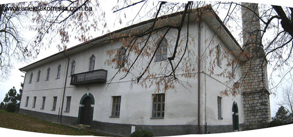
2. Description of the property
Fortifications
The old fort in Cazin consists of outer and inner ramparts. The late mediaeval fortress erected around the plateau on the summit of the hill, has a ground plan forming an irregular square, with an area of approx. 2200 m2. In the Ottoman period ramparts were built that roughly follow the outline of the mediaeval fortress, enclosing the steep, terraced area around it (Raunig, 2001, 115). The entire fortifications cover an area of approx. 5 ha. At a distance of some 50 m from the south-east angle of the Ottoman ramparts, the remains of some unidentified fortifications can be made out at the edge of the level plateau, which certainly belonged to the fortress complex.
Late mediaeval fort
It is not known, even approximately, when this fortress was built. From the ground plan, the shape of the towers, the finds of pottery shards, and historical data relating to the forts in the Krajina region north of the left bank of the Una, the fort would have been built in the late mediaeval period.
Lopašić notes that in 1890, according to the local people, a stone with an inscription that no one could read disappeared from the mediaeval ramparts. He also notes that in 1879 a new stone mosque was built using stone from the fort (Lopašić, 1943. 128-129).
The fortress is reached from the north-east by a good road suitable for motor traffic. The entrance to the fortress was in the east wall. There is no sign of the entrance now, and the upper plateau is reached by a broad paved road and concrete steps. A buttress was discovered by the tower at the south-east angle during excavations in 1974-1975. Next to this, level with the entrance at the start of the south wall, is a semicircular, open tower (diameter approx. 5 m) projecting forward from the ramparts. The upper half of the tower, with the odd surviving loophole, has vertical walls, while those of the lower part are sloping. There is another tower of the same type in the south rampart, about 20 m from the first. This rampart, which is about 50 m long, forms an approximate right angle with the partly preserved west rampart. Where the two ramparts meet, later thickening of this end section of the west rampart can be seen. Here too part of a square tower with sides 7 m long was discovered.
Whereas the remains of the south wall have been conserved to the existing height, the remains of the west and north walls are partly preserved only on the outside. The plateau of the fort is thus surrounded on two sides by a metal fence instead of by ramparts. The south-east tower contains two graves placed there since World War II.
Ottoman period ramparts
The ramparts from this period are on steep terrain and surround the mediaeval fortress on all sides except the east, where the access to the fort was. They have disappeared here and there, particularly in the south-east corner. There are only traces remaining of the west rampart. The north wall has survived in part to a height of several metres.
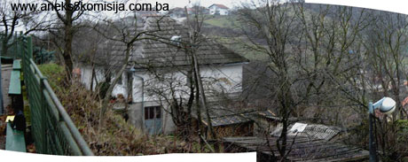
To the north, between the two ramparts, is a terraced area via which the house occupied by the imam of the mosque is reached. The house is in the north-west angle by or on part of the ramparts of the Ottoman fortifications. It was built in 1970.
Mosque
In 1576 the Ottomans built a mosque on the site of the present-day mosque within the ramparts of the mediaeval fortress. This mosque was demolished in 1879, and that same year a new one was built, originally with a wooden minaret, which was one of the largest mosques in Bosnia and Herzegovina. According to Kreševljaković, 2000 people could pray there (Kreševljaković, 1935, 17; Bećirbegović, 1990, 140).
The mosque forms an elongated rectangle, with overall dimensions of 14.2 x 28.3 m. The height of the building from floor to ceiling level is 7.90 m. It was built of stone, with walls 85 cm thick, plastered on the exterior and whitewashed on the interior. The hipped roof was clad with tiles, but in 2002 was clad with Swedish sheet metal imitating tiles. In outward appearance, this mosque is completely different from other mosques. All four sides of the white-painted facades of the mosque are divided into two levels by a projecting line.
The mosque has 39 windows arranged in two horizontal rows. The lower windows are rectangular (approx. 110cm wide x 160 cm high). There are windows set in both the outer and inner sides of the wall. The outer windows are metal, with nine 3 x 3 panes; the inner windows are wooden.
The upper windows (approx. 110 cm wide x 160 cm high) terminate in a triangle (Bećirbegović, 1990, 141). Here too there are windows both inside and out; metal outside and wooden inside.
There is a row of 8 windows on the upper storey on the south-west and north-east sides. The south-west facade has a similar row on the ground floor as well. Under the third window on the north-east facade (as seen from the north-west) there is a small wooden gallery on the upper storey and an entrance at ground floor level. To the left and right of the mihrab in the south-east facade there are two windows on each level. At the top of this facade, above the mihrab, a small circular window has been added.
The north-west facade with its later addition of a minaret and entrance has two windows on each storey (Bećirbegović, 1990, 141).
The original wooden minaret was replaced in 1924 by a slender stone minaret about 31 m high, with an open gallery (šerefe), to the right of the entrance.
The masonry of the square base of the minaret, which is about 8.50 high, is probably of machine-worked stone. It is divided by a simple string course at the same height as the string course on the mosque wall. At the top of the base, below the moulded string course that accentuates the transition to the conical section, is a string course decoracted with stylized ornamentation in relief.
At the base of the minaret is a stone plaque with an inscription incised in itm, reading: “O God do not turn away our hearts after directing us and bestowing thy mercy upon us. O God, thou are he who will save the world on the day of judgment. 1343” (1924 CE). The name of the architect who built the minaret that year is incised alongside the inscription “Lj. Missoni” (Mujezinović, 1982, 74).
The sixteen-sided body of the minaret is slightly conical in form. The minaret is approx. 17.50 m high to the šerefe, and approx. 24.50 m to the steeple; the overall height without the alem (finial) is approx. 29.00 m.
The minaret is not plastered, nor are the decorations on it painted. As well as the base, the body of the minaret is decorated with stone mouldings. The top and bottom of the body of the minaret are accentuated by a simple string course. The part below the šerefe is decorated with a frieze of blind arcades. The šerefe parapet has no mouldings.
The steeple of the minaret is clad in sheet metal.
The entrance to the minaret is from inside the mosque, via the mahfil.
The mosque has two entrances. The main entrance (1.60 x 2.40 m) is on the front, north-west side, to the left of the base of the minaret. The second entrance, of the same size as the main one, is to the north-east. Both terminate in round arches with the initial and key stones emphasized. The entrance doors to the mosque are double wooden doors.
When the mosque was renovated in 2002, short inscriptions (ayats from the Qur'an) were painted on the facades in black above both portals.
The interior of the mosque is divided into three levels. The ground floor consists of a large entrance area, 7.5 m deep, with two symmetrically located staircases leading to the mahfil. The area is divided into three: the central area leading to the prayer space, an abdesthana (for ritual ablutions) to the right of the entrance, and a mekteb (Islamic primary school) to the left. The conversion of the premises was carried out in 2002.
The prayer space, measuring 12.5 x 18.4 m with a height of 7.8 m, has two rows of wooden pillars supporting the mahfil and ceiling. The mahfil is set along three walls, and the low wooden railing follows the row of pillars at both ground and upper floor level. The open area in front of the mihrab (6.5 x 13m) is elongated and surrounded by pillars and a railing, interrupting the single prayer space at ground floor level. Eleven crocks have been built into the walls of the mahfil, 25 cm deep with a 20 cm opening (Bećirbegović, 1990, 141).
A wooden staircase leads from the mahfil to the attic, which was converted into a prayer space in 2002. According to the locals, this area was previously used for prayer as well. This is the only way Kreševljaković's claim that 2000 people could pray in the mosque can be understood (Bećirbegović, 1990, 140).
The roof structure consists of quadruple sloped studs supporting angle beams running in two directions. The beams and rafters are covered with wooden wainscoting. The attic conversion was carried out in 2002.
The ground floor and the mahfil are both of the same area, 230 m2, so that the total area of these two levels amounts to 460 m2. To this should be added the attic, with an area of approx. 125 m2 . All the interior features are carefully decorated.
The mihrab frame is rectangular, with simple moulding and no decoration. The outer moulding is painted yellow ochre, and the frame itself dark green. The mihrab opening has an exceptionally high mihrab crown, with a levha (calligraphic inscription) in the centre.
The semicircular mihrab niche, which is about 0.70 m wide and is painted light green, is overarched with painted stalactite decoration in yellow ochre and black.
The mimber is wooden and consists of three sections: the portal and stairway with its wooden railing, the upper pyramidal section resting on four square pillars joined by arches, and the triangular side sections below this section and the stair rail. The portal at the front is closed by a cloth. The pillars of the portal are spindle-shaped, with extremely high bases. The sides of the mimber are completely enclosed by boards, with a passageway under the podium (the area to which the mimber stairway leads). The passageway below the podium is closed off by a wooden door.
The treatment of the wooden pillars with corbels on which the mahfil is supported was accorded the greatest care. The circular spindle-shaped pillars are set on high square bases with 30 cm sides and terminate in square capitals decorated with wood carving. The corbels above the capitals are very pronounced, richly moulded, and decorated with volutes (Bećirbegović, 1990, 141, 156). The pillars are painted white and the bases and corbels are beige. The spindles of the mahfil railing are spiral, and have small bases and capitals.
House of the imam of the mosque
The imam's house, built in the late 1970s, is to the north-west of the main entrance to the mosque, and linked to the mosque by steps, since the house is at the point where the north and west Ottoman ramparts meet. The building is almost square in ground plan, measuring 9.0 x 8.50 m, with two storeys (ground and upper floor). It has a shingled hipped roof.
3. Legal status to date
The monument is on the Provisional List of National Monuments under the title Cazin – mosque in the fortress, under serial no. 166.
Stage B, Valorization, 1980-2002, of the Regional Plan lists the old Cazin fort and mosque in Cazin as a Category 2 monument.
4. Research and conservation and restoration works
- 1974-1975 prior to the conservation of the ramparts, experts from the Una Valley Regional Museum carried out archaeological excavations, when the square tower by the west wall of the fort and the buttress in the south-east corner were discovered and conserved (Jusić, 1975, 143-145; idem, 1983, 241). The collapse of the ramparts posed a threat to the mosque from the south-east. As a result, the south-east rampart was rebuilt along its entire length to the height of the surviving sections.
- From 19 July to 2 August 1991, archaeological excavations were conducted on the site proposed for the construction of a mekteb, on the north-west plateau of the fort between the inner and outer ramparts. The mekteb was not in fact built.
- In October 2002, works were carried out on the mosque:
- central heating was installed
- the attic was converted to a prayer space
- an inscription with verses from the Qur'an was installed above the entrance door
- the mosque roof was clad with Swedish sheet metal imitating tiles
The mosque committee, representing the jamaat (congregation), was the initiator, sole decision-maker and funder of the works. The project designer was Mirsad Džaferović, a graduate civil engineer, and chief designer in the company Domus MM Cazin. The works contractors were the companies Limometal and Elektrometal of Cazin. Both the project design and the execution of the works respected the building’s authenticity, apart from the use of modern roofing material, in an attempt to imitate tiles.
5. Current condition of the property
The outer ramparts dating from the Ottoman period are largely ruinous and in places almost entirely stripped bare. The revetment of the ramparts has been almost completely destroyed, partly by overgrowth and partly by human action. The local population who have houses below the north rampart of the fort in particular is fearful of the stones that fall from the ramparts from time to time.
The outer revetment of the north rampart of the mediaeval fortress is also in a ruinous state, partly covered with earth and overgrowth.
The upper plateau on which the mosque stands has been landscaped as a park area and partly surrounded by a metal fence. Steps lead alongside the north rampart from the imam's house to the mosque entrance. Since the mosque requires running water, pipes have been laid in a concrete channel through or alongside the north rampart.
III – CONCLUSION
Applying the Criteria for the adoption of a decision on proclaiming an item of property a national monument (Official Gazette of BiH nos. 33/02 and 15/03), the Commission has enacted the Decision cited above.
The Decision was based on the following criteria:
A. Time frame
B. Historical value
C. Artistic and aesthetic value
C.iii. proportions
C.iv. composition
D. Clarity
D.i. material evidence of a lesser known historical era
D.ii. evidence of historical change
D. iv. evidence of a particular type, style or regional manner
E. Symbolic value
E.iii. traditional value
E.v. significance for the identity of a group of people
F. Townscape/ Landscape value
F.ii. meaning in the townscape
F.iii. the building or group of buildings is part of a group or site
G. Authenticity
G.v. location and setting
H. Rarity and representativity
H.i. unique or rare example of a certain type or style
The following documents form an integral part of this Decision:
- Copy of cadastral plan
- Photodocumentation;
- Drawings
Bibliography
During the procedure to designate the monument as a national monument of Bosnia and Herzegovina the following works were consulted:
1934. Kreševljaković, Hamdija, Cazin i okolina (Cazin and Environs) Sarajevo, 1934.
1943. Lopašić, Radoslav, Bihać i bihaćka krajina (Bihać and the Bihać frontier region) 2nd ed., Zagreb, 1943.
1952. Kreševljaković, Hamdija, Prilozi povijesti bosanskih gradova pod turskom upravom. (Contributionsn to the history of Bosnian towns under Turkish rule) Papers on oriental philology and the history of the Yugoslav peoples under Turkish rule, II/1951, Orientalni institute Sarajevo, Sarajevo, 1952,119-184.
1953. Kreševljaković, Hamdija, Stari bosanski gradovi (Old Bosnian towns/forts) Naše starine I, Sarajevo, 1953, 7-45.
1957. Vego, Marko, Naselja srednjovjekovne bosanske države. (Settlements of the mediaeval Bosnian state) 1957.
1974. Bojanovski, Ivo, Dolabelin sistem cesta u rimskoj provinciji Dalmaciji.(Dolabella's roads system in the Roman province of Dalmatia) Academy of science and the arts of Bosnia and Herzegovina, Proceedings, bk. XLVII, Centre for Balkan Studies, bk 2, Sarajevo, 1974.
1975. Jusić, Enisa, Cazin, srednjovjekovni grad. (Cazin, mediaeval fort) Archaeological survey of the Federation of Archaeological Societies of Yugoslavia XVII/1975, Belgrade, 1975,143-145.
1971. Bešlagić, Šefik, Stećci, kataloško-topografski pregled. (Stećak tombstones, a catalogue and topographical survey) IRO Veselin Masleša, Sarajevo, 1971.
1982. Šabanović, Hazim, Bosanski pašaluk (The Bosnian pashaluk) Svjetlost, Sarajevo, 1982,
1983. Jusić, Enisa, Informacija o stanju arheološke istraženosti srednjovjekovnih gradova na području Pounja. (Information on the extent of archaeological investigation of mediaeval forts in the Una basin), Collected papers of the Archaeological Society of BiH, bk.1, Sarajevo, 1983, 239-242.
1982. Mujezinović, Mehmed, Islamska epigrafika BiH. (Islamic Epigraphics of BiH) Bk. III, IRO “Veselin Masleša”Sarajevo, 1982
1990 Bećirbegović, Madžida, Džamije sa drvenom munarom (Mosques with wooden minarets). IRO Veselin Masleša, Sarajevo, 1990.
1991 Kreševljaković, Hamdija, Kapetanije u Bosni i Hercegovini. (Captaincies in BiH) In: Selected Works I, IRO Veselin Masleša, Sarajevo, 1991.
2001 Raunig, Branka, Prahistorijski nalazi na srednjovjekovnom gradu Cazinu (Prehistoric finds in the mediaeval fort of Cazin). Jnl of the National Museum of Bosnia and Herzegovina, Archaeology, new series, vol. 48/49, Sarajevo, 2001,115-163.
2004. Bajrić, Azra, Cazin. Cazin Municipality and Cultural Centre, Cazin, 2004.
|