Status of monument -> National monument
Published in the “Official Gazette of BiH” no. 75/08.
Pursuant to Article V para. 4 Annex 8 of the General Framework Agreement for Peace in Bosnia and Herzegovina and Article 39 para. 1 of the Rules of Procedure of the Commission to Preserve National Monuments, at a session held from 15 to 21 March 2005 the Commission adopted a
D E C I S I O N
I
The architectural ensemble of the old Dobor fort, Municipality Modriča, is hereby designated as a National Monument of Bosnia and Herzegovina (hereinafter: the National Monument).
The National Monument consists of the fort and the archaeological artefacts housed in the National Museum of Bosnia and Herzegovina in Sarajevo and the Museum in Doboj,
The National Monument is located on a site designated as cadastral plot nos. 70/1 and 70/2 (old survey) 1661 and 1662 (new survey), title sheet no. 152; Land Registry entry no. 29, cadastral municipality Jakeš, Municipality Modriča, Republika Srpska.
The provisions relating to protection measures set forth by the Law on the Implementation of the Decisions of the Commission to Preserve National Monuments, established pursuant to Annex 8 of the General Framework Agreement for Peace in Bosnia and Herzegovina (Official Gazette of Republika Srpska no. 9/02) shall apply to the National Monument.
II
The Government of Republika Srpska shall be responsible for ensuring and providing the legal, scientific, technical, administrative and financial measures necessary for the protection, conservation and presentation of the National Monument.
The Commission to Preserve National Monuments (hereinafter: the Commission) shall determine the technical requirements and secure the funds for preparing and setting up signboards with basic details of the monument and the Decision to proclaim the property a National Monument.
III
To ensure the on-going protection of the National Monument, the following protection measures are hereby stipulated:
Protection Zone I consists of the area defined in Clause 1 para. 3 of this Decision. The following protection measures shall apply in this zone:
- all works are prohibited other than research and conservation and restoration works, including those designed to display the monument, with the approval of the Ministry of Republika Srpska responsible for regional planning and under the expert supervision of the heritage protection authority of Republika Srpska (hereinafter: the heritage protection authority);
- the site of the National Monument shall be open and accessible to the public, and may be used for educational and cultural purposes;
- the dumping of waste is prohibited.
To ensure the on-going protection of the National Monument, the following measures shall be carried out:
- clearing the ramparts of the fort, the walls of the towers, other areas and surroundings of self-sown vegetation posing a threat to the structure of the monument;
- the structural repair of the towers and ramparts in places where cracks have appeared which may cause the entire structure to collapse;
- during structural repair, conservation and restoration works, original materials and binders shall be used wherever possible;
- during repair works, the existing stone blocks shall be used;
- the treatment of the surface of the repaired wall must match that of the rest of the wall;
- the crown of the wall must be of natural materials (stone coping or topping with hydraulic mortar);
- larger cracks must be filled with a compound of small pieces of stone and hydraulic lime mortar;
- self-sown vegetation must be physically removed. The use of weedkillers and other chemical substances is not recommended;
- The following shall also be carried out in addition to these repair and conservation works:
- the entire protected area and buffer zone of the National Monument shall be demined;
- systematic archaeological investigations shall be carried out below the Dobor tower as far as the river Bosna and of the part of the riverbed within the protected zone;
- the retaining structures along the riverbank and those in the cutting of the hill where the fort is located shall be completely landscaped;
- an approach road or path to the National Monument shall be provided;
- an information point and “checkpoint” shall be set up at the start of the approach road in order to manage the Dobor tower;
- any remains found during archaeological investigative works shall be protected and suitably presented at the investor’s expense;
- any information that may arise from the archaeological investigations that was not known at the time this Decision was adopted, and that could indicate the need for a protection regime different from the one determined by this Decision, the Commission may amend the Decision in line with its Rules of Procedure.
Protection Zone II covers c.p. nos. 1503, 1504, 1505, 1506, 1663, 1665 and 1666.
The following protection measures shall apply in this buffer zone:
- all building and works of any kind that could have the effect of altering the site or the landscape are prohibited;
- works of any kind to the infrastructure are prohibited unless with the approval of the relevant ministry and with the expert opinion of the heritage protection authority;
- the dumping of waste is prohibited.
In order to obtain consent for works on the protected area, the results of the archaeological investigations must be submitted to the Commission, together with surveys of the site to a scale of 1:200 or 1:250, typical cross-sections at the points where the road comes close to the fort (necessarily including a cross-section of the point at which the road is at its closest to the fort), and geodetic plans of the site to a scale of 1:1000.
IV
All executive and area development planning acts not in accordance with the provisions of this Decision are hereby revoked.
V
The removal of the archaeological artefacts referred to in Clause 1 para. 2 of this Decision (hereinafter: the movable heritage) from Bosnia and Herzegovina is prohibited.
By way of exception to the provisions of paragraph 1 of this Clause, the temporary removal from Bosnia and Herzegovina of the movable heritage for the purposes of display or conservation shall be permitted if it is established that conservation works cannot be carried out in Bosnia and Herzegovina.
Permission for its temporary removal from Bosnia and Herzegovina under the conditions stipulated in the preceding paragraph shall be issued by the Commission, if it is determined beyond doubt that it will not jeopardize the movable heritage in any way.
In granting permission for the temporary removal of the movable heritage from Bosnia and Herzegovina, the Commission shall stipulate all the conditions under which the removal may take place, the date by which the items shall be returned to the country, and the responsibility of individual authorities and institutions for ensuring that these conditions are met, and shall notify the Government of the Federation of Bosnia and Herzegovina, the relevant security service, the customs authority of Bosnia and Herzegovina, and the general public accordingly.
VI
Everyone, and in particular the competent authorities of Republika Srpska, and urban and municipal authorities, shall refrain from any action that might damage the National Monument or jeopardize the preservation and rehabilitation thereof.
VII
The Government of Republika Srpska, the Ministry responsible for regional planning in Republika Srpska and the heritage protection authority of Republika Srpska, and the Municipal Authorities in charge of urban planning and land registry affairs, shall be notified of this Decision in order to carry out the measures stipulated in Articles II – VI of this Decision, and the Authorized Municipal Court shall be notified for the purposes of registration in the Land Register.
VIII
The elucidation and accompanying documentation form an integral part of this Decision, which may be viewed by interested parties on the premises or by accessing the website of the Commission (http://www.aneks8komisija.com.ba)
IX
Pursuant to Art. V para 4 Annex 8 of the General Framework Agreement for Peace in Bosnia and Herzegovina, decisions of the Commission are final.
X
This Decision shall enter into force on the date of its adoption and shall be published in the Official Gazette of BiH.
This Decision has been adopted by the following members of the Commission: Zeynep Ahunbay, Amra Hadžimuhamedović, Dubravko Lovrenović, Ljiljana Ševo and Tina Wik.
No:05.2-2-67/05-4
16 March 2005
Sarajevo
Chair of the Commission
Amra Hadžimuhamedović
E l u c i d a t i o n
I – INTRODUCTION
Pursuant to Article 2, paragraph 1 of the Law on the Implementation of the Decisions of the Commission to Preserve National Monuments, established pursuant to Annex 8 of the General Framework Agreement for Peace in Bosnia and Herzegovina, a “National Monument” is an item of public property proclaimed by the Commission to Preserve National Monuments to be a National Monument pursuant to Articles V and VI of Annex 8 of the General Framework Agreement for Peace in Bosnia and Herzegovina and property entered on the Provisional List of National Monuments of Bosnia and Herzegovina (Official Gazette of BiH no. 33/02) until the Commission reaches a final decision on its status, as to which there is no time limit and regardless of whether a petition for the property in question has been submitted or not.
Pursuant to the provisions of the law, the Commission proceeded to carry out the procedure for reaching a final decision to designate the Property as a National Monument, pursuant to Article V of Annex 8 and Article 35 of the Rules of Procedure of the Commission to Preserve National Monuments..
II – PROCEDURE PRIOR TO DECISION
In the procedure preceding the adoption of a final decision to proclaim the property a national monument, the following documentation was inspected:
- Data on the current condition and use of the property, including a description and photographs, data of war damage, data on restoration or other works on the property, etc.;
- Copy of land registry entry and details of ownership;
- Historical, architectural and other documentary material on the property, as set out in the bibliography forming part of this Decision.
The findings based on the review of the above documentation and the condition of the site are as follows:
1. Details of the property
Location
The site where the old Dobor fort is located is known as Gradina Dobor (Dobor Hillfort) or Dobor kula (Dobor tower). The fortress was built on the route to the town of Modrič, on a slight incline dominating the surrounding area, just above the left bank of the river Bosna. The slopes of Mt Vučjak tower over the fort a mere 100 metres away. The fort is about 4 km upstream from Modriča, where the slopes of Mt Vučjak and Trebavac are so close that the Bosna valley narrows into a gorge, at a point where there has always been a crossroads, with the road hugging the river.
There was formerly a ferry across the river Bosna below Dobor, over which the road led to the forts of Sokola (near Gračanica) and Srebrnika on the Tinja and thence to the Soli district around the town of Tuzla. One branch of the road led to the river Sava at Šamac, where there was also a ferry; this was the main crossing from Slavonia into Bosnia, or Usora. This was the route by which the Hungarian army most easily penetrated into Bosnian territory in the mediaeval period. The fort is now away from the main road.
The National Monument is located on a site designated as c.p. nos. 70/1 and 70/2 (old survey) 1661 and 1662 (new survey), c.m. Jakeš, Municipality Modriča, Republika Srpska.
Historical information
The few remains identified during archaeological investigations indicate that there were already fortifications of some kind on this site in prehistoric times. During the construction of the new road alongside the Bosna river in 1975, on the south slope below the fort, the remains of a prehistoric fort were discovered.
Finds dating from antiquity on the site of the fort and the slope down to the river Bosna included a few metal artefacts and pieces of brick and tile (Bojanovski, 1981, 25). Ivo Bojanovski, who conducted the investigations on the fort, is of the view that the remains were discovered of parts of an earlier mediaeval fort, on which the present-day fort was later built.
Dobor was in the mediaeval župa (county) of Nenavište. The boundaries of Nenavište coincide roughly with the municipalities of Gradačac, Modriča, Orašje, Bosanski Šamac-Šamac and Odžak.(1) A charter issued by ban Stjepan II Kotromanić in 1329 indicates that the village of Jakeš on the left bank and Modriča on the right bank of the river Bosna, in other words the immediate area of the Dobor fort, belonged to Nenavište.
In the late mediaeval period the Nenavište župa was divided into two smaller districts with Gradačac and Dobor as their district towns. This suggests the presence of fortifications in these places (Anđelić, 1982, 147, nn. 21 and 24).
The earliest written sources on Dobor date from the time of the wars waged by Hungary’s King Sigismund against Bosnia in the late 14th and early 15th century. During the 1380s, there were protests in Croatia against the centralist policies of King Sigismund. The malcontents were led by the brothers Pavao (the Bishop of Zagreb) and ban Ivaniš Horvat. Bosnia’s King Tvrtko I took advantage of this unrest by coming to the aid of the rebels and thereby acquiring almost the whole of Croatia south of Velebit along with the coastal towns. In 1389 he proclaimed himself king of Croatia and Dalmatia. At that time (between 1387 and 1390), the Horvat brothers, allies of Tvrtko, took refuge in Dobor, remaining there and, after the king’s death in 1391, continuing to wage war on Sigismund even though Tvrtko I’s successor, King Dabiša, was compelled in 1393 to come to terms with Sigismund in Đakovo over the Bosnian crown. In line with the obligations imposed on Dabiša at Dobor in 1394, which were agreed to by some of Bosnia’s landowners, Sigismund of Luxembourg was to be crowned king of Bosnia. That same year, Sigismund moved against the Horvats, occupied and burned Dobor, and captured and punished the Horvat brothers. Sigismund’s charter of 15 July 1394 in descensu nostro campestri sub castro Dobor vocato (in the military camp under the fort called Dobor) dates from that campaign. Since Sigismund did not in fact acquire the Bosnian crown, he waged five military campaigns against Bosnia from 1398 to 1408 (twice in 1398, and again in 1406, 1407 and 1408).
A deed of gift issued by Sigismund on 17 February 1401 to the Kanjiški Archbishop Ivan and his brothers for their faithful service between 1389 and 1397 states that his (Sigismund’s) enemies on the borders of his country had built and equipped the Dobor fort (Bojanovski, 1982, 25, nn. 39-41). Sigismund came to power in 1387, which means that the Horvat brothers acquired Dobor from King Tvrtko I and built a new fort there in the early years of Sigismund’s reign, between 1387 and 1394, when Sigismund captured the fort and set it on fire (Bojanovski, 19).
The opposition to Sigismund was led by Duke Hrvoje Vukčić Hrvatinić, in whose possession were nearby Jakeš and Modriča (Anđelić, 1982, 1489).
Dobor was probably in the royal demesne, as suggested by the fact that Tvrtko I allowed the Horvat brothers to take refuge in Dobor.
A charter dated 1 August 1406, under the terms of which Sigismund gifted the Gorjanski brothers for their services between 1386 and 1403, also refers to the razing of Dobor in 1394.
The Bosnian aristocracy, unhappy with King Dabiša’s pro-Hungarian policies, chose Tvrtko II as king. This provoked Sigismund into meddling with Bosnia’s affairs once again. In the battle of Dobor in the autumn of 1408, the Bosnian army was defeated, and more than a hundred Bosnian nobles were killed on Sigismund’s orders. Two documents dated 26 May and 5 June 1408 are evidence of Sigismund’s presence sub castro nostro Dobor. After this war, Ostoja, who had become king of Bosnia for the second time, acknowledged Sigismund’s overlordship. However, the war continued in 1410 and 1411 as a result of Bosnian resistance; Sigismund retained the northern districts of Usora and Soli, while Ostoja ruled Bosnia proper and the land of Hum as his vassal (Ćirković, 1964, 211). War broke out again in 1415 and Sigismund, defeated in battle in Doboj, withdrew from Bosnia, where he lost Usora and Soli. From then on he no longer meddled to any great extent in Bosnian affairs (Ćirković, 1964, 243). In Dobor, on 11 November 1499, King Stjepan Tomaš entered into a defensive treaty against the Ottomans with the ban of Mačva Ivan of Korođo, as János Hunyadi’s emissary.
A letter dated 13 June 1457 sent from Dobor by Pietro Tomasi, the Venetian envoy, reported that King Stjepan Tomaš had decided to terminate his vassal relationship with the sultan. At that time the Papal Legate Cardinal John Carvajal was also staying in Dobor (Frankoi, 1890, 9-12).
From 1463 to 1536, to judge from reports in 1499, 1528 and 1536m, Dobor was ruled by Hungaro-Croatian nobles, among whom the Slavonian nobles of the Berislavić family held power longest (the earliest reference to them dates from 1470, calling them comes perpetuus de Dobor (Bojanovski, 1972, 247-248; ibid 1981, 27, nn. 51 and 52, and p. 32)). Dobor was part of the Srebrenik banate and suffered the same fate as other fortresses, mainly as a result of the lack of resources to defend the fort (Bojanovski, 1981, 28; Truhelka, 1904, 75).
With the fall of the Srebrenik banate, Dobor too came under Ottoman rule. The Serbian despote in Hungary P. Bakić reported to Vienna on 27 August 1536 that Husrev beg had taken Dobor. The fort was merged with the Bosnian sandžak and Brod kadiluk (Šabanović, 1982, 150). A 40-strong garrison was stationed in the fort. Husrev beg also endowed 150 beehives in Dobor. The first known dizdar (garrison commander) of Dobor was Muhjudin aga, until 1587. He was succeeded by his son Jusuf-aga, who held the post until 1610. He in turn was succeeded by his son Aga Dede, a scholarly man who was born in Dobor and left a description of it. This work, dating from 1622-1633, gives the names of all the dizdars from 1536 to 1623 (Kreševljaković, 1953, 21; Bojanovski, 1981, 28).
In a description of his bishopric dated 1655, Bishop Marijan Maravić says that Dobor was still in use (Milobar, 1904, 254). The 1711 census of Bosnian spahis records Dobor as the seat of the nahija of the same name (Skarić, 1930, 41, 42; Anđelić, 1982, 147; Šabanović, 1982, 177).
The fort was abandoned in 1716 during the Austro-Turkish war. It was occupied in a lightning assault on 21 November 1716 by Colonel Petraš, and the Ottoman garrison of some 200 men retreated towards Gračanica. A military report states that the Austrians razed the fort (Bojanovski, 1981, 28, n. 59).
Although under the terms of the Treaty of Passarowitz Dobor remained under Ottoman rule, it was left abandoned, and its role was taken over by Derventa. A military report of 1737 describes it as an abandoned fort (Bodenstein, 1908, 98), and in 1785 an Austrian spy described it as an old, fairly well fortified but abandoned fort (Kreševljaković, 1953, 22).
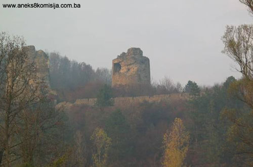
2. Description of the property
The Dobor fort is one of the few examples of late mediaeval defensive architecture that has retained its original form, hence its cultural and historical value.
It went through a number of stages in the course of its history, which are recognizable and identifiable in the present ruins.
First to be built was a free-standing tower (A), to which was soon added a bailey (B), and another, still larger tower or keep (C).
The assumption is that all this was completed by the early 15th century, when the fort was taken by King Sigismund.
During the 15th century the area of the fort was extended to the eastern plateau. What remains today of the fort mainly dates from the first half of the 15th century. Since the fort had no great strategic importance in later years, it was not turned into an artillery fortress with bastions, but retained the appearance of a mediaeval fortress.
The central complex of the fort (the acropolis), consisting of two massive towers, the smaller eastern tower A and the western tower C, with a bailey (B) between them, stands on the highest point of the site.
Since Dobor was built on a spot that, in the pre-firearms age, was exposed to enemy attack, the site needed to be isolated from the surrounding terrain before the castle was built. To this end fosses and moats were cut to either side, east and west, from which the stone was also extracted to build the fort.
During archaeological excavations, the buried remains of two buildings belonging to the oldest stage of the fortifications were uncovered. Tumulus O, as Bojanovski denoted it on his plan of the fort, is on a man-made motte at the east end of the outer enceinte. The structure was created on bedrock excavated to a depth of 0.6 m, creating a fosse 0.5 m wide. The foundations were then laid in the fosse on 20cm square beams. Judging from the appearance of these beams, the base of the structure was polygonal (a hexagon or octagon) with a diameter of 5.5 to 6 m. The lower part of the structure was built of stone and red-clay mortar, and the upper part of timber. It was destroyed by fire, and not rebuilt. It was erected as a small fortification in the pre-firearms age, probably in the 14th century, and probably destroyed during the battles of the late 14th and early 15th centuries (Bojanovski, 1981, 20-21).
The second structure, designated as tumulus O1, was probably contemporary with building O. The remains (approx. 1 m in height) of a stone tower measuring 4.43 x 3.80 were excavated to the east of tower A and the wall of the inner enceinte, at the point where walls run down from the north and south walls of the tower, winding around the sloping terrain with a re-entrant below the rampart of the inner enceinte (E). These walls, which were deliberately demolished to free up the site, were 1.7 m thick (Bojanovski, 1981, 21).
Tower A was built at a time when cannon had already come into use, and is of irregular cylindrical shape. The inner measurements of the usable space at the base are 5.5 x 5.1 m. The diameter of the tower at the top is 9.5 m, and in the lower section is 10 m, meaning that its walls were built with a splay (chamfer) of approx. 5%. The tower was additionally reinforced to the north and east by a massive stone wall. The tower had four storeys, including the underground part dug about 1.5 m into the rocky ground, and the attic, which has been demolished. The height of the walls of the tower is approx. 18 m on the outside and 20 m on the inside. The storeys were separated by a structure of timber joists.
The entrance to the tower was on the third storey, to the south-west. Apertures for firearms were probably beneath the roof, but that part is now entirely missing. All that has been discovered are parts of two window jambs (Bojanovski, 1981, 14).
Bailey B, which is 16 m long and 8 m wide, lies between the eastern tower A and the western tower C. The walls of the bailey were not structurally interlinked with the small tower (A), indicating that they were built at a rather later date. The south wall (facing the river Bosna) is rather lower than the north rampart, since there was no danger from the south side of the fort. The wall is about 2 m thick, and probably had a walkway along the top with battlements and arrowslits. Excavations in the bailey identified two strata:
- an upper stratum about 1 m thick with rubble from fallen walls, and
- a lower stratum about 1.3 m thick consisting of a ramp as additional reinforcement for the ramparts of reduced height.
The lower stratum lay on artificially levelled rocky ground. It seems that the bailey was gradually filled with earth, since it was in the lowest stratum that the greatest quantity of mediaeval artefacts was found. Presumably, prior to its being earthed over, there was a timber-built structure of some kind in the bailey. No well was found inside the ramparts (Bojanovski, 1981, 16).
Tower C was a later addition in the curvature of the western part of the bailey when the corner of the bailey was rebuilt and the outward-facing curvature built on. The tower thus acquired the shape of an inverted D. At a later stage the wall around the tower was twice reinforced, from the inside by a layer up to 0.4 m thick and on the outside by 1.65 m. The width of the curtain wall, measured on the western side, is 4.25 m. The interior usable width of the tower is approx. 6 m. The chemise wall narrows in width towards the top of the tower by 1.5 to 2 m. The thickness of the wall on the bailey side was no more than 2 m, narrowing towards the top on the outside. The highest surviving part of this tower, with a height of 19.5 m, is to the north, where the terrain slopes steeply down to Munjači brook. Including the upper storey, which has long since fallen into ruins, the tower would have been 24 m high.
The ground floor of tower C, used as a dungeon, was below the ground level of the bailey. A cell measuring 2.97 x 1.6 m, with a depth of 1.8 m, was excavated in the stone floor of the tower. The tower was entered from the courtyard. The door was on the third floor, and there were loopholes or some other kind of aperture on the fifth floor, below the roof: one on the bailey side and one to the west. The area between the third and fifth storeys was entirely enclosed and dark.
At the heart of the fortifications of rounded outline, the solid curtain walls and slopes of towers A and C are associated with the introduction of firearms. The organization of the defensive space in these new conditions, with the greater firepower of artillery, called for additional construction, as a result of which bailey D with an inner bailey (Zwinger) E were added to the south and east.
Inner bailey (E) (outer wall or Zwinger)
A narrow bailey took shape around the heart of the fort, the acropolis, in the shape of a rather wide passage. The wall around the fort was about 1.1 m thick and surrounded three sides of the fort, apart from the north wall of bailey B. The wall of the inner bailey was fitted with loopholes at various levels, depending on the variations in height of the wall to adjust to the uneven terrain. The wall of the inner bailey has survived to a height of 0.8 to 1.5 m. At some time the wall was pulled down and the stones used to fill in part of the outer bailey.
The outer ward (D) took shape to the south and east with the erection of a large outer curtain wall 1.5 m thick. This outer curtain wall is approx. 8 m high and enclosed an area 86 m long and 32 m wide. To judge from the splay of the walls, they completed the development and construction of this fortress in the mid 15th century.
The oldest entrance to the fort was in the eastern part of the south rampart, where the fort was naturally protected by the steep banks of the river Bosna.
There was a second, normal-sized gate in the north rampart below tower A, large enough for men on horseback to pass through it, and perhaps even carriages. This gate too was later walled up and a third entrance made in the eastern side of the ramparts.
There was a mediaeval burial ground belonging to the Dobor fort on the south slope towards the river Bosna. This was damaged during the construction of the road along the left bank of the Bosna in 1975 (Bojanovski, 1981, 25, n. 37b).
It was probably in the 16th century that the wall of the inner bailey (E) that enclosed the space between the outer and inner fortifications was filled with earth, while tower C was reinforced on the outside. It was then, too, that the western part of ward D was earthed up to further reinforce the ramparts and create a platform for cannon, thereby enhancing the defensive capacity of the fortress.
During battles in the late 17th and early 18th century, parts of the fort were deliberately demolished, as can be seen in the lower reaches of tower C and on the smaller tower A. It was probably then, too, that the hoarding and breastworks on the ramparts of bailey B were demolished. The south rampart of the outer ward was also badly damaged at that time. The northern part of the rampart was pulled down in about 1950 (Bojanovski, 1981, 12-13).
The chronological stages over which Dobor was built and altered are as follows:
- Stage I – buildings O and O1 and remains of the rampart alongside building O1 (13th and 14th century);
- Stage II – parts of the fort: tower A and bailey B, and perhaps parts of tower C and of the outer ward D, built during the time the Horvat brothers resided in the castle between 1387 and 1394;
- Stage III – reconstruction of the demolished fort between 1394 and 1408. It was then, probably, that tower C and the stone outer rampart in the western part of outer ward D were completed;
- Stage IV – from 1415 (Sigismund’s defeat in the battle of Doboj) to 1463 (founding of the Srebrenik banate) and in particular during the reign of King Tomaš in the second half of the 15th century. Construction of the fortress completed, including inner bailey E and the entire outer ramparts of the outer ward;
- Stage V – 16th and 17th century, when the fort was adapted to some extent to ever greater artillery firepower. The inner bailey was demolished, the ramparts were lowered in height, ward D was earthed up and turned into an artillery platform.
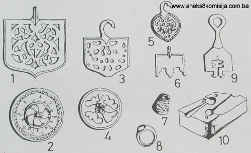
Movable artefacts
There were numerous pottery finds, lying scattered all over the fort, both inside and outside the buildings. These included local late mediaeval pottery, imported blue maiolica, and so-called Hungarian pottery, as well as pottery loom weights.
Shards of glazed pottery vessels and clay pipes date from the Ottoman period.
There were numerous metal artefacts: various iron tools and military accessories: scissors, hammers, blacksmiths’ tongs, chains, nails, sundry knives, door furniture, šerke, bolts and leg-irons, found in the dungeon in tower C.
The weapons excavated included numerous arrows and javelins, and still greater numbers of crossbow bolts, spears, one Gothic spur, military horseshoes and a part melted suit of chain mail.
Artefacts of other metals included pieces of cast bronze cannon barrels and one brass ring.
Stone artefacts found included parts of grindstones, two moulded window jambs from tower A and a stone cannonball.
A total of 29 coins were found in Dobor, spanning the entire history of the fortress: four in the small tower A and 14 in tower C, with the remainder excavated in the bailey.
The coins found were:
- a silver Dubrovnik dinar of 1366,
- 24 Hungarian coins dating from the reign of Sigismund (1386-1437), Vladislav (Ulászló) I (1440-1444), Mathias (Mátyás) Corvinus (1458-1490), Bosnia’s king Nikola Iločki (Nicholas of Ilok) (1471-1477), and Louis (Lajos) II (1516-1526),
- 2 mangura (small denomination Ottoman Turkish copper coins) minted during the reign of Suleyman II (1687-1691),
- 2 Austrian coins with the inscription of Archduke Leopold of 1689.
3. Legal status to date
By Ruling of the National Institute for the Protection of Cultural Monuments and Natural Rarities of NR BiH Sarajevo, no. 276/51, dated 28 February 1951, the property was placed under state protection, and by Ruling of the Institute for the Protection of Cultural Monuments of NR BiH Sarajevo no. 02-751-3 dated 18 April 1962, the old Dobor fort, Odžak municipality, state-owned, cadastral plot nos. 70/1 and 70/2, was placed under state protection and entered on the Register of immovable cultural monuments. This Ruling came into force on 24 October 1962.
The 1980 Regional Plan for Bosnia and Herzegovina listed the property as a Category 2 cultural and historical property.
4. Conservation and restoration works
- 1957, the Institute for the Protection of Cultural Monuments of BiH carried out minor conservation and restoration works (Naše starine, XIII, XIV-XV);
- 1958, experts from the Regional Museum in Doboj took soundings in the bailey;
- from 1969 to 1973 the Institute for the Protection of Cultural Monuments of BiH, funded by Modriča Municipal Council, carried out archaeological excavations over much of the fort in order to discover all its demolished and buried structures. Based on this, an outline plan for the reconstruction needed partly to restore the monument was drawn up. At the same time, extensive conservation works and part restoration was carried out:
- the towers of the fort were stabilized by being fitted with reinforced concrete ring beams to prevent further deterioration,
- new stone revetments were reinforced by steel mesh,
- the entrance to the large tower was restored,
- conservation works were completed on the perimeter ramparts and the ramparts facing the river Bosna were rebuilt,
- the rampart by the small tower and gate was rebuilt.
During the course of these works, there were some departures from the features identified during the excavations and incorporated into the conservation programme. These were on the perimeter section of the ramparts facing the river Bosna as regards the part restoratioin of the breastworks, and on the breastworks in bailey B.
There were also certain departures from the plan in the restoration works on the gate in the south rampart. These were the result of the builders’ failure to follow the prescribed design solutions (Naše starine, XIII, XIV-XV).
The restoration did not include the reconstruction of the high ramparts on the perimeter since there is no documentation on the earlier appearance of the upper part of these walls.
All that survived of the original apertures in the south rampart are the two original narrow loopholes and a narrow gate between them, probably the main entrance to the fort, which was made rather higher than originally during renovation.
The entire research and conservation works were led by Ivo Bojanovski in association with Aleksandar Ninković, an architect with the Institute for the Protection of Monuments (Naše starine, XIII, XIV-XV).
5. Current condition of the property
Certain conservation and restoration works were carried out in the 1980s to the programme, design project and subsequent oversight of the Institute for the Protection of the Cultural, Historical and Natural Heritage of Bosnia and Herzegovina.
Since more than twenty years have elapsed since the last conservation and restoration works, naturally enough there has been some damage to the property, caused by lack of regular maintenance as well as the use of certain inappropriate building materials and techniques.
For safety reasons – the possible presence of a minefield, which the local population warned me about – it was not possible to enter the fort, and consequently impossible to estimate the exact extent of damage that has arisen.
On photographs of the fort extensive damage can be seen on the towers (to the south, facing the river Bosna). The cause of „bellying“ on the revetments of the walls, and subsequently of stone blocks falling away from their original positions, is the penetration of precipitation into the body of the walls which, as a result of inadequate drainage, has washed out the binder materials from the joints and interior structure. About 80% of the surface of the ramparts is at risk or damaged.
Extensive damage is also visible on the crowns and copings of the towers and perimetre walls. The cause is once again the penetration of precipitation into the structure, insufficient drainage and the breakdown of binder materials. Many stone blocks have fallen away from their original positions and it is not known if they are still on site.
Rank vegetation was observed on the entire site, both on and around the ramparts and on the towers and within the fort.
The fort is at particular risk from an active landslide about 300 metres to the east of the fort, which occurs every spring. The existing access road is also in very poor condition.
During the course of preparing the Decision for publication, the Commission approached the Ministry of Transport and Communicationsof BiH with a request for further discussions on the content of the Decision and the scope of the protection regime, in the light of new findings by the team of planners, designers and environmental engineering specialists made while analyzing the possible route of the Vc motorway corridor by the Dobor tower.
On receipt by the Commission of the proposal that, under specific conditions, the motorway run just below the National Monument along the route of the present-day main road, and on presentation of a comparative analysis of the proposal and other possible solutions, the Commission held meetings with the Ministry of Regional Planning, Civil Engineering and the Environment of Republika Srpska and the Institute for the Protection of the Cultural, Historical and Natural Heritage of RS, and it was agreed that the proposal from the Ministry of Transport and Communications of BiH could be accepted and the protection regime altered to allow for work to continue on the proposed motorway subject to the following conditions:
- that the investor demine the protected area and buffer zone of the National Monument;
- that systematical archaeological investigations be conducted below the Dobor tower as far as the river Bosna and of the part of the riverbed within the protected zone;
- that the investor take the greatest possible care to prevent any damage or threat to the monument during or after the road-building works on the motorway;
- that after completing the motorway works the investor landscape the entire retaining structures along the river bank and in the cutting of the hill where the fort is located;
- that the investor provide an approach road or path to the National Monument;
- that the investor erect an information point and „checkpoint“ at the foot of the approach road for the purpose of management of the Dobor tower;
- that any remains found during archaeological investigative works be protected and suitably presented at the investor’s expense.
When applying for a building permit, the investor is required to submit to the Commission the results of the archaeological investigations, together with surveys of the site to a scale of 1:200 or 1:250, typical cross-sections at the points where the road comes close to the fort (necessarily including a cross-section of the point at which the road is at its closest to the fort), and geodetic plans of the site to a scale of 1:1000.
In the event of information arising from the archaeological investigations that was not known at the time this Decision was adopted, and that could indicate the need for a protection regime different from the one determined by this Decision, the Commission may amend the Decision in line with its Rules of Procedure.
III – CONCLUSION
Applying the Criteria for the adoption of a decision on proclaiming an item of property a national monument (Official Gazette of BiH nos. 33/02 and 15/03), the Commission has enacted the Decision cited above.
The Decision was based on the following criteria:
A. Time frame
B. Historical value
C. Artistic and aesthetic value
C.iii. proportions
C.iv. composition
D. Clarity
D.i. material evidence of a lesser known historical era
D.ii. evidence of historical change
D.iv. evidence of a particular type, style or regional manner
E. Symbolic value
E.iii. traditional value
E.v. significance for the identity of a group of people
F. Townscape/ Landscape value
F.ii. meaning in the townscape
G. Authenticity
G.i. form and design
G.iv. traditions and techniques
H. Rarity and representativity
H.i. unique or rare example of a certain type or style
I. Completeness
I.i. physical coherence
Bibliography
During the procedure to designate the architectural ensemble of the old Dobor fort as a national monument of Bosnia and Herzegovina the following works were consulted:
1890. Franko, Vilim, „Kardinal Karvajal u Bosni 1457“ (Cardinal Karvajal in Bosnia 1457), Jnl of the National Museum in Sarajevo, vol II/1890, bk. I. Sarajevo, 1890, 9-12.
1904. Truhelka, Ćiro, Naši gradovi, opis najljepših sredovječnih gradova Bosne i Hercegovine. (Our forts, description of the finest mediaeval forts of BiH), Sarajevo, 1904.
1904. Milobar, Fran, “Dva savremena izvještaja o Bosni iz prve polovine XVII stoljeća” (Two contemporary reports on Bosnia from the first half of the 17th century), Jnl of the National Museum in Sarajevo, vol XVI/1904, Sarajevo, 1904, 251-266.
1908. Bodenstein, Gustav, “Povijest naselja u Posavini” (History of settlements in the Sava valley region), Jnl of the National Museum in Sarajevo, vol XX/1908, Sarajevo, 1908, 95-112.
1930. Skarić, Vladislav, “Popis bosanskih spahija iz 1123. (1711) godine” (Census of Bosnian spahis of 1123 [1711 CE]), Jnl of the National Museum in Sarajevo, vol. XLII, vol. 2, Sarajevo, 1930, 1-99.
1953. Kreševljaković, Hamdija, “Stari bosanski gradovi” (Old Bosnian forts), Naše starine, I, Sarajevo, 1953, 7-45.
1964. Ćirković, Sima, Istorija srednjovekovne bosanske države (History of the mediaeval Bosnian state), Belgrade, 1964.
1972. Bojanovski, Ivo, “Dobor- kula” (Dobor – tower), Naše starine, XIII, Sarajevo 1972, 245-248
1981. Bojanovski, Ivo, “Dobor u Usori (sjeverna Bosna) (Rezultati arheoloških istraživanja 1969-1973)” (Dobor in Usora [northern Bosnia]. Findings of archaeological investigations 1969-1973) Naše starine, XIV-XV, Sarajevo 1981, 11-38.
1982. Anđelić, Pavao, “O usorskim vojvodama i političkom statusu Usore u srednjem vijeku” (On the military leaders and political status of Usora in the mediaeval period), In: Studije o teritorijalnopolitičkoj organizaciji srednjovjekovne Bosne (Studies on the territorial and political organization of mediaeval Bosnia), Sarajevo, 1982, 142-172.
1982. Šabanović, Hazim, Bosanski pašaluk (The Bosnian pashaluk), Sarajevo, 1982.
(1) M. Dinić, “Oblast kralja Dragutina” (The District of King Dragutin), Glas, 203 (1951) 76; M. Blagojević, Severna granica bosanske države u XIV veku (The Northern Borders of the Bosnian State in the 14th Century), papers for an international seminar on Bosnia and Herzegovina from mediaeval to modern times, held from 13-15 December 1994, SANU (Serbian Academy of Science and Art), Historical Institute, Proceedings, vol. 12, 59-75, map p. 730
|