Status of monument -> National monument
Pursuant to Article V para. 4 Annex 8 of the General Framework Agreement for Peace in Bosnia and Herzegovina and Article 39 para. 1 of the Rules of Procedure of the Commission to Preserve National Monuments, at a session held from 15 to 21 March 2005 the Commission adopted a
D E C I S I O N
I
The historic structure of the bridge in Plandište (the “Roman” bridge; the bridge over the river Bosna in Plandište) is hereby designated as a National Monument of Bosnia and Herzegovina (hereinafter: the National Monument).
The National Monument is located on a site designated as cadastral plot nos. 249 and 250 (new survey), corresponding to parts of c.p. no. 237/2, cadastral municipality Vrelo Bosne (old survey), Municipality Ilidža, Federation of Bosnia and Herzegovina, Bosnia and Herzegovina.
The provisions relating to protection and rehabilitation measures set forth by the Law on the Implementation of the Decisions of the Commission to Preserve National Monuments, established pursuant to Annex 8 of the General Framework Agreement for Peace in Bosnia and Herzegovina (Official Gazette of the Federation of BiH nos. 2/02, 27/02 and 6/04) shall apply to the National Monument.
II
The Government of the Federation of Bosnia and Herzegovina (hereinafter: the Government of the Federation) shall be responsible for ensuring and providing the legal, scientific, technical, administrative and financial measures necessary to protect, conserve, and display the National Monument.
The Commission to Preserve National Monuments (hereinafter: the Commission) shall determine the technical requirements and secure the funds for preparing and setting up signboards with the basic data on the monument and the Decision to proclaim the property a National Monument.
III
To ensure the on-going protection of the National Monument, the following protection measures are hereby stipulated:
Protection Zone I consists of the area defined by the following boundaries:
- north of the Roman bridge, by a strip between the old Ilidža-Blažuj asphalt road and the old road on c.p. nos. 249 and 250, c.m. Vrelo Bosne,
- south of the Roman bridge and the track of the old road on c.p. nos.249 and 250, c.m. Vrelo Bosna, by a strip approx. 150 metres wide extending from 200 metres to the west of the Roman bridge to 200 metres east of the Roman bridge.
The following protection measures shall apply in Protection Zone I:
- all works are prohibited other than conservation and restoration works with the approval of the Federal Ministry responsible for regional planning (hereinafter: the relevant ministry) and under the expert supervision of the heritage protection authority of the Federation of Bosnia and Herzegovina (hereinafter: the heritage protection authority),
- all protection works, regardless of their nature and extent, must be carried out on the basis of prior approval from the relevant ministry
- all motor vehicle traffic over the Roman bridge is prohibited
- all new construction of residential, commercial, agricultural or other buildings and facilities is prohibited
- the regular cleaning and maintenance of the bed of the river Bosna shall be permitted
- the dumping of all kinds of waste, stone, earth, mine waste an dother solid or liquid matter and materials is prohibited
- works of any kind to the infrastructure are prohibited other than in exceptional cases with the approval of the relevant ministry and under the expert supervision of the heritage protection authority,
- the following are prohibited: altering the course of the river Bosna, any action that could damage the bed and banks of the river Bosna or impede the free flow of the river Bosna, the extraction of river gravel, sand, stone etc. from the bed of the river Bosna, installing fish-farming facilities or equipment in the waters of the Bosna, placing floating objects in the river Bosna, and any kind of pollution of the river Bosna.
IV
All executive and area development planning acts not in accordance with the provisions of this Decision are hereby revoked.
V
Everyone, and in particular the competent authorities of the Federation of Bosnia and Herzegovina, the Canton, and urban and municipal authorities, shall refrain from any action that might damage the National Monument or jeopardize the preservation and rehabilitation thereof.
VI
The Government of the Federation, the relevant Ministry, the heritage protection authority, and the Municipal Authorities in charge of urban planning and land registry affairs, shall be notified of this Decision in order to carry out the measures stipulated in Articles II to V of this Decision, and the Authorized Municipal Court shall be notified for the purposes of registration in the Land Register.
VII
The elucidation and accompanying documentation form an integral part of this Decision, which may be viewed by interested parties on the premises or by accessing the website of the Commission (http://www.aneks8komisija.com.ba)
VIII
Pursuant to Art. V para 4 Annex 8 of the General Framework Agreement for Peace in Bosnia and Herzegovina, decisions of the Commission are final.
IX
This Decision shall enter into force on the date of its adoption and shall be published in the Official Gazette of BiH.
This Decision has been adopted by the following members of the Commission: Zeynep Ahunbay, Amra Hadžimuhamedović, Dubravko Lovrenović, Ljiljana Ševo and Tina Wik.
X
On the date of adoption of this Decision, the National Monument shall be deleted from the Provisional List of National Monuments of Bosnia and Herzegovina (Official Gazette of BiH no. 33/02, Official Gazette of Republika Srpska no. 79/02, Official Gazette of the Federation of BiH no. 59/02, and Official Gazette of Brčko District BiH no. 4/03), where it featured under serial no. 528.
No: 06.1-2-75/03-3
15 March 2005
Sarajevo
Chair of the Commission
Amra Hadžimuhamedović
E l u c i d a t i o n
I – INTRODUCTION
Pursuant to Article 2, paragraph 1 of the Law on the Implementation of the Decisions of the Commission to Preserve National Monuments, established pursuant to Annex 8 of the General Framework Agreement for Peace in Bosnia and Herzegovina, a “National Monument” is an item of public property proclaimed by the Commission to Preserve National Monuments to be a National Monument pursuant to Articles V and VI of Annex 8 of the General Framework Agreement for Peace in Bosnia and Herzegovina and property entered on the Provisional List of National Monuments of Bosnia and Herzegovina (Official Gazette of BiH no. 33/02) until the Commission reaches a final decision on its status, as to which there is no time limit and regardless of whether a petition for the property in question has been submitted or not.
The Commission to Preserve National Monuments issued a decision to add the Plandište bridge to the Provisional List of National Monuments of BiH under serial no. 528.
Pursuant to the provisions of the law, the Commission proceeded to carry out the procedure for reaching a final decision to designate the Property as a National Monument, pursuant to Article V of Annex 8 and Article 35 of the Rules of Procedure of the Commission to Preserve National Monuments.
II – PROCEDURE PRIOR TO DECISION
In the procedure preceding the adoption of a final decision to proclaim the property a national monument, the following documentation was inspected:
- Data on the current condition and use of the property, including a description and photographs,
- Details of war damage, data on restoration or other works on the property, etc.
- Copy of cadastral plan
- Historical, architectural and other documentary material on the property, as set out in the bibliography forming part of this Decision.
The findings based on the review of the above documentation and the condition of the site are as follows:
1. Details of the property
Location
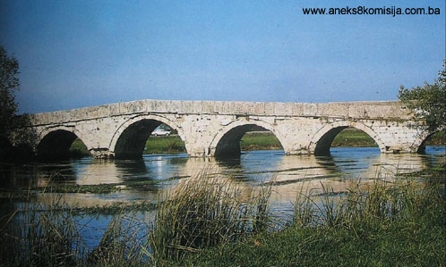
The bridge over the river Bosna in Plandište(1) was erected on the way out from Sarajevo to the west, two kilometres downstream from the source of the river Bosna, 1,300 metres from the nearest slopes of Mt Igman, and three km south-east of Blažuj. Like the Kozja ćuprija (Goat bridge), which symbolically constitutes the east gates to the city of Sarajevo, the Roman bridge is the west gates.
Historical information
Territorially speaking, the river Bosna basin has been the focus of assembly and settlement since ancient times. Ilidža(2) is at the centre of the oldest area in the Sarajevo region where the remains of Neolithic, Illyrian and Roman settlements are found, as well as the thermal baths used during the Roman, Ottoman and Austro-Hungarian periods as well as since.
In 1893 a chance discovery, followed by systematic excavations from 1896 onwards, uncovered a Neolithic culture settlement which developed around 2400-2000 BCE.
It is known from Roman sources that the area was settled by Illyrians, whose culture is associated with the Iron Age, i.e. the 1st millennium BCE. After about three centuries of incessant fighting, in 9 CE, the Romans occupied much of the Balkan peninsula, or Illyria.
One of the most important Roman roads ran through Ilidža, and the Roman settlement of "Aquae ... S” was the administrative and cultural centre of the entire district. There are material remains of the Roman civilization in Stupsko brdo, Osijek, and Crkvište in Blažuj. Thanks to systematic archaeological investigations in Ilidža in the 1950s and early 1960s, Roman buildings, floor mosaics, pottery, jewellery and coins have been preserved.
In the 10th century the area was the centre of the župa (county) of Vrhbosna, and in the 15th century it became the centre of the Sarajevo sandžak. Major and well-frequented routes led to and from this social, political and commercial centre.
The trade route linking Dubrovnik with central Bosnia crossed Mt Ivan and led to Tarčina, where it forked, with one fork leading towards Vrhbosna and Visoko. A stretch of the Vrhbosna road still survives along the Ilidža and Sarajevo road. There was a crossroads in Plandište, where the roads from the Bosna valley and those from the east and south intersected.
These specific features of the microlocation of Plandište, and the fact that there was never a settlement in the immediate vicinity of the bridge, suggest that the bridge was not of a communal nature but was built for the purpose of interurban communications.
The importance of these routes, as well as the development of the settlement and continuity of habitation in Ilidža, suggest(3) that there was a bridge on the site of the present-day bridge in Roman and mediaeval times, although there is no surviving documentary evidence to this effect.
The writings of later travel chronicles provide a basis for the assumption that the present-day bridge was “extensively renovated, if not actually built from the foundations up” between 1530 and 1550(4), since the earliest reference in writing to a bridge in Plandište is that of the Venetian envoy Catarino Zeno, who passed through Sarajevo in 1550. In his travelogue, he note that coming from the north he came to Blažuj ("Blazuda"), where he spent the night. The next day he crossed the river Bosna, after which, as he observes, the entire country is named, noting of the river that its source is beneath a mountain of which he does not know the name, and that it “is immediately a large river, with a seven-arched bridge leading over it, from which one can see it welling up from the mountain.(5)”
It is not known who the “renovator, if not the founder of the bridge”(6) was, but the assumption is to be found among scholars that the builders of the bridge in Plandište could have been Grand Vizier Rustem-paša Hrvat, or Semiz Ali-paša or Gazi Ali-paša(7).
Relatively full information on repairs to the bridge has been preserved. Quote: “The most interesting details date from 1762, when interested citizens of Sarajevo appealed to the Bosnian vizier to repair the bridge, which was damaged and barely passable. Kadić cites, primarily, an arzuhal of 28 May 1762 with the following information:
‘The ulema, agas and ćehajas (heads) of the guilds came to the court and stated that the bridge on the main Mostar and Travnik road near Blažuj over the river Bosna wsas damaged, and that it was very difficult for passers-by to cross, particularly the poor people bringing their farm produce and other things to market. The inhabitants of the surrounding villages have undertaken to provide their labour to restore the bridge to its original condition. This arzuhal is submitted to Your Excellency [the Bosnian vizier] to request your approva for the necessary works and funds for the repairs. 5 Dhu l-Qa’dah 1175 [28 May 1762]. Sarajevo kadi Muhamed.’
This arzuhal was followed a mere three days later by a bujruldija (decree) from the Bosnian vali of 31 May 1762. A commission consisting of the Sarajevo kadi, Muhamed, the Sarajevo kajmekam, Smailbeg, and master masons, with a number of other prominent figures, then visited the site and drew up an estimate of costs for the repairs to the bridge, dated 21 Dhu l-Hijjah 1175 (12 July 1762).
The estimate begins by listing the following materials for building a wooden bridge to be erected to the west of the stone bridge, which would be 260 arshins long and 5 arshins wide:
for the roadway, 1,300 oak beams each 5 arshins long
oak beams for the cladding, 10 arshins long x 60 = 3,300
large logs for the ridge, 85, = 19,440
oak beams 84, 5 arshins long, for the so-called baba
for the roadway, 3,900 nails or 487 okas [1 oka = 3 lbs] x 20 = 9,750
main loadbearers 4 x 60 = 240
nails for the baskije [wooden railings] 165 = 410
urgan (?) 4 x 30
craftsmen to work the timber 300 per diems plus meal = 12,000 akčas.
It then notes that the stone bridge requires repairs to the korkaluk (parapet) over a length of 31 arshins and on two places to the paving at the edges of the bridge, and the removal from the water of the parapet stones that have fallen in.
The total estimated sum for materials and labour was 117,300 (akča) or 977 groschen and 1 zlota. This estimate was forwarded to the Bosnian vali, who responded on 26 Dhu l-Hijjah with a bujruldija 1175 (17 July 1762) approving the start of the works as soon as possible, requiring tents to be pitched on the building site and ordering that the works and materials be under strict supervision.” (end quote) (8).
In 1952, when the road was being reconstructed, it was noted that the width of the bridge was totally inadequate for motor vehicle traffic. As a result, in order to preserve it in its authentic condition, it ceased to be used, and a new reinforced concrete bridge suitable for modern traffic was built about 150 m downstream. It should be noted that the route taken by the stretch of the new road between Ilidža and Blažuj was altered, so that the stone bridge in Plandište ceased to form a functional part of this stretch of road.
2. Description of the property
The bridge in Plandište is the only surviving stone bridge over the entire course of the river Bosna, and probably the only one ever built, since it is not known whether the Čekrekči hajji Mustafa and Davud-paša bridges in Visoko were built of stone or not.
Though the name of the builder of the present-day bridge is not known, the form, details and workmanship suggest that it is the work of local craftsmen(9).
The structure of the bridge fits extremely well into the natural surroundings, with all the features affecting the disposition (outline of longitudinal profile, configuration of the terrain, water levels at various seasons and flooding of the river Bosna, with its broad riverbed at this point) studied in depth and resolved appropriately in the construction of the bridge. This is particularly true of the long ramps(10), with flood openings(11) (the larger of which is rectangular and measures 40 x 100 cm) serving to carry away excess water when water levels are at their highest, so preventing the surroundings of the bridge from being flooded
The bridge has seven round arches, and a roadway typical of Ottoman bridge-building: the height and width of the spandrel walls and barrels of the bridge increase rhythmically towards the centre, with the highest point above the fourth (central) arch of the bridge. The aperture(12) of the first arch, from east to west, is 3.30 m, the second 4.10 m, the third 4,90 m, and the fourth and central 5.70 metres.
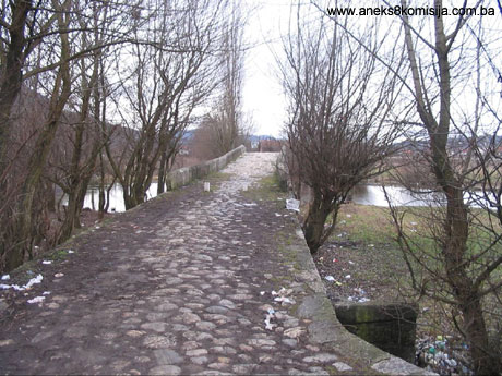
The access ramp from the east is 85.30 metres long. The bridge itself is 52.10 metres long, 4.55 metres wide including the parapet, and approx. 4.50 metres high at its highest point(13).
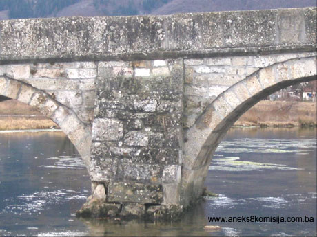
The bridge has six river piers (the average cross-section of the foot of the piers is approx. 1.80 x 5.00 metres) with breakwaters on the upstream, south-west side, while the third(14) pier is reinforced on the downstream side by a masonry buttress abutting onto the spandrel wall of the bridge. The buttress, which is approx. 3.10 to 3.20 m in height(15), is of regular wedge shape, rectangular in cross-section(16).
The parapet, which is approx. 75 cm high and approx. 30 cm wide, is separated visually from the spandrel wall of the bridge by a simply moulded stone string course, and the arches are slightly recessed in relation to the surface of the spandrel walls.
The bridge was built of cut limestone bonded by lime mortar, and the stone slabs of the parapet, like the stone segments of the barrel, are joined by iron cramps fixed in lead. The roadway over the bridge is paved, with the paving stones set in cement mortar.
Roman spoil was built into the parapet on the downstream side, in the shape of a stone slab with bas relief on the surface, as a result of which this bridge is often known to the locals as the Roman bridge. There is no information on this relief in the literature available to us(17). The relief is of a naked, standing figure, with the left leg crossed over the right, the right hand raised above the head, and the left arm crossed over the chest.
3. Legal status to date
By Ruling of the National Institute for the Protection of Cultural Monuments and Natural Rarities of the National Republic of Bosnia and Herzegovina in Sarajevo no. 685/50 dated 10 June 1950, the monument was accorded legal protection, and by Ruling of the Institute for the Protection of Cultural Monuments of the National Republic of Bosnia and Herzegovina of Sarajevo no. 02-672-3 dated 18 April 1962, the bridge over the river Bosna in Plandište, state-owned (Assembly of Ilidža Municipality), was entered in the Register of Immovable Cultural Monuments.
The 1980 Regional Plan for Bosnia and Herzegovina lists the Bridge over the Bosna near Blažuj as a category I monument (monument of national importance).
The property is on the Provisional List of the Commission to Preserve National Monuments of Bosnia and Herzegovina under the title Plandište Bridge, serial no. 528.
The bridge in Plandište is located within Protection Zone I (zone enjoying the highest degree of protection) of the protected area of sources of drinking water in Sarajevo plain.
4. Research and conservation and restoration works
During the 20th century the bridge was used for motor vehicle traffic, which became so heavy in the year following World War II as to lead to the inappropriate use of the bridge, causing serious structural damage. To adapt the longitudinal profile of the roadway to modern traffic conditions, it was earthed up and the roadway raised on both abutment sides of the bridge by more than 100 cm by means of an earth ramp, and the roadway paved with granite setts; there was also some concrete reinforcement to the underwater sections of the piers.
In the early 1980s, experts from the City Institute for the Protection and Maintenance of Cultural Monuments recorded the deformation and friability of parts of the walls, barrels and parapet, lateral deformation of the walls (shifting from the vertical and bulging on the walls), and the presence of two self-sown trees causing much of the line of the wall to shift. It was noted that, despite the deformations, most of the stone blocks could be used to rebuild the bridge, and that missing or badly damaged blocks could be replaced by new cut “hreša” limestone blocks.
In order to carry out test and analytical works to investigate the original appearance of the roadway and the original superstructure of the bridge, three soundings were taken: at the start of the roadway structure of the bridge to the east, in the roadway above the second pier to the east, and at the end of the roadway structure to the west. All three soundings were taken by the parapet on the downstream side.
The structural repair works and restoration and conservation carried out during the 1980s can be classified as follows:
- removal of the later addition of an embankment and roadway from the bridge and restoring the original longitudinal profile of the roadway and the original superstructure, with restoration of the paving,
- repair and restoration of parts of the string course and parapet
- removal of banked-up earth from the bankside piers of the bridge, excavating the seventh arch and barrel to the west of the bridge, excavating and uncovering the access ramp and removing self-sown vegetation and trees growing in the masonry of the bridge,
- rebuilding and rectifying the deformed and friable masonry structure of the bridge and repairing the spandrel walls,
- surface protection and conservation of the monument to protect it from weathering, condensates and the damaging effects of industrial pollution.
The possibility was considered of injecting the load-bearing structures, but it was concluded that the restoration of the original roadway of the bridge and of the original superstructure, and structural repair works to the bridge, as well as banning motor vehicle traffic over the bridge, would result in the maximum possible reduction in the static and dynamic stress on the bridge, so that would not be necessary to inject the loadbearing substructure of the bridge.
On the upstream side of the bridge, new breakwaters were made of “hreša” limestone for piers 4 and 5, and the breakwaters of piers 1, 2 and 3 were dismantled and rebuilt using the same blocks of stone.
Barrel A, the first barrel to the east of the bridge, was dismantled after numbering the blocks of tufa, and rebuilt, replacing about 10% of the blocks, which were missing or badly deteriorated. When the barrel was rebuilt, 1:2:6 lime cement mortar was used. The same process was applied when partly rebuilding the spandrel walls of the bridge.
The concrete extension to the top of the parapet was removed and the parapet was consolidated, cleaned and the joints sealed, with some of the slabs replaced by new ones.
The restored paving (with approx. 70% of the existing slabs retained) was laid on a layer of sand with an average depth of approx. 10 cm, using pure river sand with average granulation of 1-5 mm. The joints were set in white 1:2 cement mortar. The layer of sand was laid on an infill layer of stone and a final layer of gravel (with an average depth of approx. 15 cm). A base layer of tamped concrete with an average thickness of 10 cm using MB 10 was laid on upper side of the bare structure of the barrels of the bridge, followed by hydroinsulation (albite + 2 layers of verbitex 30 with contact coating of bitulite and 3 coasts of 85/25 bitumen).
Instead of the usual products used for the surface protection and conservation of monuments (water glass, colloidal silicium acid and silicium acid ester), “sandsteinverfestiger H”(18) was used to protect the monument from weathering, condensates and the damaging effects of industrial pollution. This product was used in order to increase the depth of penetration into the interior structure of the stone (by 100% as compared with the products previously used), to reduce the damaging effects of sodium sulphate on the stone (a 4-fold reduction), and to enhance the pressure-resistance of the stone following treatment with this product.
The second stage consisted of works to make good the approach to the bridge over a length of about 50 m on either side. The earth roadway was restored and stabilized with paved strips at regular intervals. The stone wingwalls on the western approach to the bridge were repaired and rectified, concreted components were removed, and the facades of the walls were cleaned and repointed.
5. Current condition of the property
This bridge is regarded as one of the best preserved bridges in Bosnia and Herzegovina dating from the Ottoman period. The bridge is no longer used for motor vehicle traffic, but is reserved solely for pedestrian use.
An on site inspection of the structure in January 2005 ascertained that it is in relatively good condition.
On completion of the works in 1986, experts from the City Institute for the Protection and Maintenance of Cultural Monuments of Sarajevo concluded that the next stage should consist of further works to study the structure of the foundations and, once their condition was ascertained, to embark on possible repairs or reconstruction.
Since 1986, minor damage has been caused to the bridge and its roadway: considerable damage to the paved surface caused by weathering and the roots of plants that have sown themselves in the joints and on the surface of the paving and in the spandrel walls; the stone is dirty from weathering; and there is minor physical damage to stone blocks.
The damage to the eastern approach ramp is identical to that to the paving on the bridge.
Damage to the parapet mainly takes the form of considerable moss and lichen growth on the stone, and damage to the stone surfaces of the parapet.
On the upstream side of the piers, the breakwaters (built of limestone below and tufa above) are damaged in places.
The buttress reinforcing the third pier of the bridge (again, of limestone below and tufa above) has partly collapsed on the eastern side.
III – CONCLUSION
Applying the Criteria for the adoption of a decision on proclaiming an item of property a national monument (Official Gazette of BiH nos. 33/02 and 15/03), the Commission has enacted the Decision cited above.
The Decision was based on the following criteria:
A. Time frame
B. Historical value
C. Artistic and aesthetic value
C. i. quality of workmanship
C.ii. quality of materials
C.iii. proportions
C.iv. composition
C. v. value of details
C.vi. value of construction
D. Clarity
D.i. material evidence of a lesser known historical era
D.iii. work of a major artist or builder
D. iv. evidence of a particular type, style or regional manner
D. v. evidence of a typical way of life at a specific period
F. Townscape/ Landscape value
F.i. Relation to other elements of the site
F.ii. meaning in the townscape
F.iii. the building or group of buildings is part of a group or site
G. Authenticity
G.i. form and design
G.ii. material and content
G.iii. use and function
G.iv. traditions and techniques
G.v. location and setting
G.vi. spirit and feeling
G.vii. other internal and external factors
H. Rarity and representativity
H.i. unique or rare example of a certain type or style
H.ii. outstanding work of art or architecture
I. Completeness
I.i. physical coherence
I.ii. homogeneity
The following documents form an integral part of this Decision:
o Copy of cadastral plan
o Copy of land register entry and proof of title;
o Photodocumentation;
o Drawings
Bibliography
During the procedure to designate the bridge in Plandište (the Roman bridge, the bridge over the river Bosna in Plandište) as a national monument of Bosnia and Herzegovina the following works were consulted:
1969. Čelić, Džemal, Mujezinović, Mehmed, Stari mostovi u BiH (Old bridges in BiH), Sarajevo, 1969
1976 Project for the repair and maintenance of the old bridge over the Bosna in Plandište, City Institute for the Protection and Maintenance of Cultural Monuments Sarajevo
1989 Škaljić, Abdulah: Turcizmi u srpskohrvatskom jeziku (Turkicisms in Serbo-Croatian), Sarajevo, 1989
1996 Šamić, Midhat: Francuski putnici u Bosni na pragu XIX stoljeća i njihovi utisci o njoj, (French travellers in BiH at the turn of the 19th century and their impressions of the country) Sarajevo, 1966, p. 15.
1997 Karabegović, Ibrahim: Sarajevo u očima stranih putopisaca od polovine šesnaestog do kraja sedamnaestog stoljeća, (Sarajevo as seen by foreign travel chronicles from the mid 16th to the end of the 17th century) Contributions to the history of Sarajevo, Papers from the academic symposium Half a Millennium of Sarajevo, held from 19 to 21 March 1993, Sarajevo, 1997, pp. 231-238, lat.
2000 Fekeža, Lidija; Gavrilović, Margita: Od dolasla Slavena do pada Bosanskog kraljevstva, (From the arrival of the Slavs to the fall of the Bosnian kingdom) Ilidža, monograph, published by Ilidža Municipality, pp.171-190
2000 Ćeman, Mirza Hasan: Ishod na Ilidžu (The source in Ilidža) Ilidža, monograph, published by Ilidža Municipality, pp.203-294
(1) “This bridge now has no specific name of its own and is usually referred to as the bridge in Plandište, the bridge near Blažuj, the bridge in the Plain... Similarly, it has no particular name in old documents, but is referred to as “Bosna basi kuprisi” (the bridge by the source of the Bosna)”
(Čelić, Džemal, Mujezinović, Mehmed, Stari mostovi u BiH, Sarajevo, 1969, p. 75. Footnote no.74, p.75, gives the reference Sidžil 17, p. 62. )
Note: Sidžils of the Sarasjevo kadi 1 – 86, Gazi Husrevbeg library in Sarajevo (GHB); Sidžils of the kadis of the various kadiluks of Bosnia and Herzegovina 1-61 (Oriental Institute in Sarajevo - OIS)
(2) (Tur.) hot springs, spa, source of healing hot springs (Škaljić, Abdulah: Turcizmi u srpskohrvatskom jeziku, Sarajevo, 1989. p. 344)
(3) “Mandić dates the bridge to the mediaeval period, while allowing for the possibility that it is even older, noting its structural similarities with the small bridge over the Tilava, except that it is much longer, because the river Bosna is wider. ‘Both bridges, however, clearly indicate the route of the mediaeval road along which travellers from the west came to Vrhbosna and then onwards to the east.’ If this assumption by Mandić is borne in mind, it must be amplified by the recollection that as long ago as antiquity the route taken by the road was approximately the same, and that, given the importance of the Aquae S... settlement in present-day Ilidža, there must have been a crossing somewhere here over the river Bosna, probably a bridge. To this day some authors refer to this bridge as the Roman bridge, which is based primarily on the Roman spoil built into the bridge.“ Čelić, Džemal, Mujezinović, Mehmed, Stari mostovi u BiH, Sarajevo, 1969, p.75.
Note: Footnote no. 75 on p. 75 gives the reference Mandić, Mihovil: Postanak Sarajeva (Origins of Sarajevo) (Special impression from “Narodne starine” XIV), 1927, p. 12
(4) “The reason for this assumption lies in the fact that in his exhaustive travelogue of 1530, Kuripešić does not refer to the bridge (from which it may be concluded that it did not exist), while, as we have seen, C. Zeno gives a fairly detailed description of it.“ (Čelić, Džemal, Mujezinović, Mehmed, Stari mostovi u BiH, Sarajevo, 1969, p. 76)
Note: Footnote no. 77 on p. 76 gives the reference Benedikt Kuripešić, Putopis kroz Bosnu, Srbiju, Bugarsku i Rumeliju 1530 (Chronicle of travels through Bosnia, Serbia, Bulgaria and Rumelia in 1530), Sarajevo 1950, (trans. from the German by Đorđe Pejanović)
(5) These quotations in double quotation marks are from Čelić, Džemal, Mujezinović, Mehmed, Stari mostovi u BiH, Sarajevo, 1969, pp. 75-76
(6) Čelić, Džemal, Mujezinović, Mehmed, Stari mostovi u BiH, Sarajevo, 1969, p. 76
(7) “Grand Vizier Rustem-paša Hrvat built a bridge somewhat closer to Sarajevo, on the river Željeznica, at roughly the same time, so it is not impossible that he also took care of this bridge. It may also be assumed that the bridge was renovated by Semiz Ali-paša or Gazi Ali-paša... “ (Čelić, Džemal, Mujezinović, Mehmed, Stari mostovi u BiH, Sarajevo, 1969, p. 76)
(8) Čelić, Džemal, Mujezinović, Mehmed, Stari mostovi u BiH, Sarajevo, 1969, pp. 77-79
(9) “The bridge has largely preserved to this day the original form it acquired in the 16th century. It is characterized by an archaic style, indicating good local stonemasons but no great familiarity with the stylistic forms of the contemporary Turkish architectural school. This allows us to conclude that it was the work of good local stonemastons, perhaps trained in the Mediterranean-Herzegovinian tradition and thus acquainted to some extent, though rather supervficially, with the Turkish architectural style and details.” (Čelić, Džemal, Mujezinović, Mehmed, Stari mostovi u BiH, Sarajevo, 1969, p. 76)
Other scholars hold similar views: “An analysis of the building methods and use of materials found in the arches of the Rustempaša bridge in Ilidža reveals a marked similarity with the architectural features of the bridge in Plandište. Both were erected at much the same time, are identical in structure and materials, and are very close to one other, which is the basis for the assumption that these two structures were built at much the same time, that they were probably the work of the same builder, or of builders from the same masons’ workshop or school. It may also be assumed that both bridges were built thanks to annvestment by the same person – Grand Vizier Rustem-paša – either during his own lifetime or from the operations of his vakuf following his death. However, other views held are that this bridge could be the product of the building activities of two high-ranking Ottoman dignitaries, Gazi Ali-paša and Semiz Ali-paša.” (Ćeman, Mirza Hasan: Ishod na Ilidžu, Ilidža, monograph, published by Ilidža Municipality, 2000, p. 251)
(10) which served to raise the level of the bridge, needed to make it passable at times of high water
(11) openings in the bridge allowing for the evacuation or flow of water at times of high water and when the river burst its banks
(12) this refers to the span of the semicircular barrels of the bridge as measured between the piers at the height of the foot of the piers (Note. E. Softić)
(13) measured from the foot of the piers to the top of the parapet
(14) looking from east to west
(15) Measured from the foot of the pier to the level of the string course below the parapet (the top of the buttress touches the base of the string course)
(16) the rectangle measures approx. 1.40 x 1.80 m at the base of the buttress, narrowing proportionately towards the top of the buttress
(17) Information obtained from experts from the National Museum in Sarajevo (op. E. Softić).
(18) Product manufactured by Wacker Chemie GmbH, Munich, Germany
|