Status of monument -> National monument
Pursuant to Article V, Paragraph 4, Annex 8 of the General Framework Agreement for Peace in Bosnia and Herzegovina and Article 39 Para. 1 of the Rules of Procedure of the Commission to Preserve National Monuments, at a session held from 25 to 31 January 2005 the Commission adopted a
D E C I S I O N
I
The Archaeological site of At Mejdan (Hippodrome) in Sarajevo is hereby designated as a National Monument of Bosnia and Herzegovina (hereinafter: the National Monument).
The National Monument consists of the archaeological site of the remains of the Bakrbaba Mosque, medresa mekteb and harem, and movable heritage found on the archaeological site that is now being housed in the National Museum of Bosnia and Herzegovina in Sarajevo, until it is finally processed.
The National Monument is located on a site designated as cadastral plot no. 1, (old survey) Land Register entry no. CXIX/53, and c.p. no. 3, (old survey) Land Register entry no. CXIX/35, cadastral municipality Sarajevo, corresponding to c.p. no. 4 (new survey) c.m. Sarajevo XIII, Municipality Stari Grad Sarajevo, Federation of Bosnia and Herzegovina, Bosnia and Herzegovina.
The provisions relating to protection measures set forth by the Law on the Implementation of the Decisions of the Commission to Preserve National Monuments, established pursuant to Annex 8 of the General Framework Agreement for Peace in Bosnia and Herzegovina (Official Gazette of the Federation of BiH nos. 2/02 and 27/02 and 6/04) shall apply to the National Monument.
II
The Government of the Federation of Bosnia and Herzegovina (hereinafter: the Government of the Federation) shall be duty bound to ensure and provide the legal, scientific, technical, administrative and financial measures necessary to protect, conserve, and display the National Monument.
The Commission to Preserve National Monuments of Bosnia and Herzegovina (hereinafter: the Commission) shall determine the technical requirements and secure the funds for preparing and setting up signboards with the basic data on the monument and the Decision to proclaim the property a National Monument.
III
In order to ensure the on-going protection of the National Monument the following measures are hereby stipulated:
The Protection Zone comprises the area defined in Clause. 1 para. 3 of this Decision. In this zone the following protection measures shall apply:
- all works are prohibited other than research and conservation and restoration works, including those designed to display the monument, with the approval of the Federal Ministry responsible for regional planning and under the expert supervision of the heritage protection authority of the Federation of Bosnia and Herzegovina (hereinafter: the heritage protection authority),
- the reconstruction of the architectural ensemble of the Bakrbaba mosque or parts thereof shall be permitted on the same site, in the same form and of the same materials of which it was originally built, on the basis of complete historicaland technical documentation on its original condition,
- the site of the monument shall be open and accessible to the public and may be used for educational and cultural purposes,
- the dumping of waste is prohibited.
A systematic archaeological examination of the site shall be conducted. All archaeological remains should be conserved and presented in situ in an appropriate manner.
All movable archaeological material must be recorded, conserved and presented in an appropriate manner.
On completion of the entire archaeological investigations, the Commission shall be provided with a report on the basis of which this Decision shall be supplemented, if required.
IV
The removal of the movable heritage items specified in Clause 1 of this Decision (hereinafter: the movable heritage) from Bosnia and Herzegovina is prohibited.
By way of exception to the provisions of paragraph 1 of this Clause, the temporary removal from Bosnia and Herzegovina of the movable heritage for the purposes of display or conservation shall be permitted if it is established that conservation works cannot be carried out in Bosnia and Herzegovina.
Permission for their temporary removal from Bosnia and Herzegovina under the conditions stipulated in the preceding paragraph shall be issued by the Commission to Preserve National Monuments, if it is determined beyond doubt that it will not jeopardize the movable heritage in any way.
In granting permission for the temporary removal of the movable heritage from Bosnia and Herzegovina, the Commission shall stipulate all the conditions under which the removal may take place, the date by which the items shall be returned to Bosnia and Herzegovina, and the responsibility of individual authorities and institutions for ensuring that these conditions are met, and shall notify the Government of the Federation of Bosnia and Herzegovina, the relevant security service, the customs authority of Bosnia and Herzegovina, and the general public accordingly.
V
All executive and area development planning acts not in accordance with the provisions of this Decision are hereby revoked.
VI
Everyone, and in particular the competent authorities of the Federation of Bosnia and Herzegovina, the Canton, and urban and municipal authorities, shall refrain from any action that might damage the National Monument specified in Clause I of this Decision or jeopardize the protection thereof.
VII
The Government of the Federation, the Federal Ministry responsible for regional planning, the Federation heritage protection authority, and the Municipal Authorities in charge of urban planning and land registry affairs, shall be notified of this Decision in order to carry out the measures stipulated in Articles II to VI of this Decision, and the Authorized Municipal Court shall be notified for the purposes of registration in the Land Register.
VIII
The elucidation and accompanying documentation form an integral part of this Decision, which may be viewed by interested parties on the premises or by accessing the website of the Commission http://www.aneks8komisija.com.ba/)
IX
Pursuant to Art. V Para 4 Annex 8 of the General Framework Agreement for Peace in Bosnia and Herzegovina, decisions of the Commission are final.
X
This Decision shall enter into force on the date of its adoption and shall be published in the Official Gazette of BiH.
This Decision has been adopted by the following members of the Commission: Zeynep Ahunbay, Amra Hadžimuhamedović, Dubravko Lovrenović, Ljiljana Ševo and Tina Wik.
No: 05.2-2-114/04-5
25 January 2005
Sarajevo
Chair of the Commission
Amra Hadžimuhamedović
E l u c i d a t i o n
I – INTRODUCTION
Pursuant to Article 2, paragraph 1 of the Law on the Implementation of the Decisions of the Commission to Preserve National Monuments, established pursuant to Annex 8 of the General Framework Agreement for Peace in Bosnia and Herzegovina, a “National Monument” is an item of public property proclaimed by the Commission to Preserve National Monuments to be a National Monument pursuant to Articles V and VI of Annex 8 of the General Framework Agreement for Peace in Bosnia and Herzegovina and property entered on the Provisional List of National Monuments of Bosnia and Herzegovina (Official Gazette of BiH no. 33/02) until the Commission reaches a final decision on its status, as to which there is no time limit and regardless of whether a petition for the property in question has been submitted or not.
On 17 May 2004 the Social Democratic Union of BiH - Stari grad branch, 63/I M. M. Bašeskije st., Sarajevo, submitted a proposal/petition to designate the archaeological site as a national monument of Bosnia and Herzegovina.
Pursuant to the provisions of the law, the Commission proceeded to carry out the procedure for reaching a final decision to designate the Property as a National Monument, pursuant to Article V of Annex 8 and Article 35 of the Rules of Procedure of the Commission to Preserve National Monuments.
II - PROCEDURE PRIOR TO DECISION
In the procedure preceding the adoption of a final decision to proclaim the property a national monument, the following documentation was inspected:
- Documentation on the location and current owner and user of the property (copy of cadastral plan and copy of land registry entry,
- Data on the current condition and use of the property, including a description and photographs, data of war damage if any, data on restoration or other works on the property if any, etc.
- Historical, architectural and other documentary material on the property, as set out in the bibliography forming part of this Decision.
The findings based on the review of the above documentation and the condition of the site are as follows:
1. Details of the property
Location
The archaeological site is in Sarajevo, on the left bank of the river Miljacka in the immediate vicinity of the Ćumurija Bridge, between Hamdija Kreševljaković and Obala Isa-beg Ishaković streets.
Historical information
In 1544 Hajji-Alija Bakrbaba built a mosque in the western part of Atmejdan(1),with a harem and mekteb to the west. The earliest reference to the mosque in written sources dates from 1565. It was built of adobe bricks and roofed with shingles and hollow tiles. With a minber, ćurs (pulpit) and musander (wall cupboard) well made of wood, and a skilfully designed minaret, it was one of the larger and more beautiful mosques of Sarajevo. It was burnt down for the first time in 1697(2).Around 1700, a new mosque was built on the site, only to be burnt down again shortly afterwards. After this fire, the local people built another one.
In 1741/42, Hajji Ismail Misrija built a medresa consisting of a dershana (classroom) and ten rooms for pupils to the east of the mosque, next to the harem. Across the street from the medresa and Bakrbaba’s Mosque, in the immediate vicinity of Ćumurija Bridge, Abdulah-efendi Kantamirija built a library.The founder of this library was a teacher in the medresa and secretary of the shari’a court, and was also engaged in transcribing books. A significant educational and cultural centre developed around the mosque and its harem, which, according to Mula Mustafa Bašeskija, served as a gathering-place for all "scholarly" men.
The importance of this centre, which flourished culturally in the 18th century, began to decline steeply in the early 19th century. In 1850, the mosque was in ruins.
The Austro-Hungarian period was a time of intensive building, by means of which the new administration met the needs both of the authorities and of the new influx of officials and others into Bosnia and Herzegovina. Immediately after the establishment of the Austro-Hungarian administration, in 1878, the mosque was turned into a military depot(3).It was finally destroyed, together with its minaret, in 1895. Bakrbaba’s mekteb was destroyed in 1895, and in its place "the vakuf administration erected a sizeable building”. Kantamirija’s library was destroyed in 1897 in the course of the regulation of the left bank of the river. The books were first transferred to Osman Sehda’s and then to the Gazi Husrev-bey library. Abdulah-efendi Kantamirija was buried in the harem of the Bakrbaba Mosque in 1774/75, as recorded in a surviving transcript of the epitaph on the tombstone (nišan). Misrija’s medresa survived until the beginning of WWII.
The harem of the Bakrbaba Mosque continued in existence even after the mosque and the school buildings were destroyed at the end of the 19th century; as confirmed by the latest archaeological research conducted in 2004. Four graves discovered in situ lie in part over the remains of the demolished walls. These graves may thus be tentatively dated to the end of the 19th or beginning of the 20th century.
In 1905, a small park was landscaped in Atmejdan, known as Filipović Square. In 1913 a music pavilion was built in the square to a design by architect Josip Pospišil. The pavilion was burned down in 1941. No burials have been conducted here since 1925, when Atmejdan was designated as a city park. The graveyard was exhumed in 1939, but only in part, or perhaps the central part, which was in the way of the landscaping of the park area(4).
There are known to have been several fountains in Atmejdan. To the right of the entrance to the Bakrbaba mosque there was a ćifte-fountain built into the harem wall(5). There were six in the mosque "courtyard" itself, and one stood in the Misrija medresa. According to Kreševljaković they remained in sue until 1878, but in 1939 there was no remaining trace of them whatsoever.
2. Description of the property
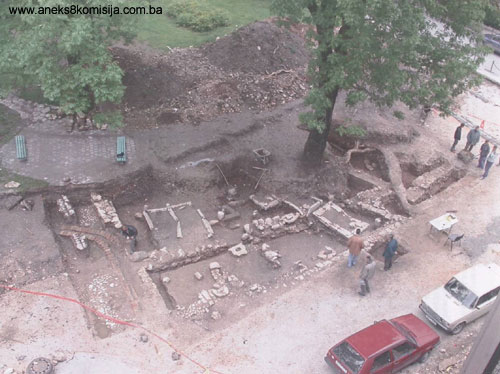
Trial digs as part of the archaeological investigations, conducted on a relatively small space (a dig of 20 x 10 m), nonetheless provided some extraordinary finds. The architectural elements found were grave surrounds, walls, the remains of cobbled and “paved” paths, all concentrated in a relatively small area. It is impossible to put an exact date to these based on what has been discovered so far, but there is enough to suggest certain conclusions.
Graves and tombstones (nišans)
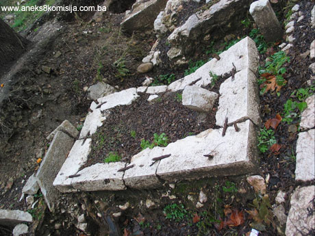
Five intact graves altogether have been found, with surviving stone frame structures (in plots no. V and VIII), and parts of graves consisting of 5 slabs (foundations) for mounting nišan tombstones, with or without bases, together with some 15 broken nišans. Some were various parts of nišans, set haphazardly upright in no particular order, while others were just lying on the ground in plots nos. IV, V, VII, VIII and XI (Plan 3, Fig. 1). Five graves with surviving santrač(6) surrounds were discovered at a depth of 0.78 to 0.91 metres, the variation depending on soil subsidence over the course of time.
On the basis of the differing designs of the surround, the graves can be divided into two groups. One consists of double graves nos. I and II, and III., and the other of nos. IV and V (Fig. 3, 4, 5, 6, 7, 8, 9 and 11). Fine white limestone was used for the construction of the surrounds.
The orientation of the graves is regular, with a slight deviation towards the north-east that is more marked on graves nos. III; IV and V.
Double grave nos. I and II. The overall width of the grave is 2.40 m, and the length 2.25 to 2.50 metres It is made of large, well shaped slabs measuring 1.0 x 0.50 x 0.10 meters, slightly shifted out of place. Three slabs are missing in the western part of the graveyard (Fig. 4, 5, 6, 7, and 8). The upper surfaces of the slabs have hollows for the iron cramps, which are also missing. In the easternmost slab of the north grave is an iron hoop, the holder of the missing nišan. On the second grave part of a rectangular nišan base 15 cm in height was found in situ.
Grave No. III is identical in shape to the previous two – with slabs set vertically (Fig. 5). However, it has not been completely excavated, since its eastern part is in the midst of the dense root system of a huge ash-tree. It is 1.35 m in width.
Graves nos. IV and V are shaped from stone blocks of varying sizes, very well cut on the upper and lateral faces (height 0.25m.). Grave no. V is smaller, measuring 1.05 x 1.08 m. It is wider than it is long, most probably as a result of the destructive effects of the roots of the ash-tree.
Of particularly interest is grave no. IV, the stone structure of which is well preserved, with visible irons cramps joining the surrounds. On the upper surface of the corner surrounds are some iron “outlets” that are a direct indication of some decorative elements on the upper vertical construction, now missing (Fig. 9). Next to the western surround, in the ground, is the slightly curved lower part of a nišan, of which the base is rectangular and the surviving height is 0.30m. The grave measures 2.20 x 1.45m.
Displaced surrounds, stone blocks well cut into rectangles, were found in the eastern profile of the trial dig (Fig. 18). These surrounds had been moved here, where they were laid “haphazardly” (Fig. 19). Given the way they were displaced, with the irons cramps connecting them still visible, it may be assumed that this was to do with the exhumation of the graves to which these santrač surrounds belonged.
At approximately the same geodetic altitude, the stone bases of nišans were found, consisting of stone slabs of elongated, irregular shape measuring approx. 0.55 x 0.45 x 0.30 metres. They appear almost to have been scattered around the space to the west of the grave No. IV (Plan 3, Fig. 5, 10, 11, 12, 13 and 14). Only one base has an empty socket for mounting a rectangular nišan (Fig. 10 ), while in the others, parts of rectangular nišans were found of varying heights, from the height of the groove itself up to 0.30 m. One nišan lies on the ground, in plot no. VIII, while the westernmost, in plot no. IV, forms part of some structure that resembles a small channel. (Fig. 14)
Several nišans found during these excavations may be said to be in their primary positions – in situ. This is true only of the remains of the bases of the nišans found in graves II and IV; all the others had been moved to their current locations at a later date, after either the exhumation or levelling of the terrain. Four nišans (Fig. 7) are found in a very unusual position, in a row below the north-eastern part of graves I and II, with next to them the upper part of a nišan of hexagonal cross-section with a pointed top. The four nišans have square, slender shafts (measuring 14 x 14 cm in section), narrowing slightly at the neck.
Two pieces of different nišans were found (Fig. 15), set side by side very close to the south side of grave II. One is octagonal in cross-section, with a diameter of 27cm, while the other is circular in cross-section, with a diameter of 14 cm. Part of a nišan was found in an upright position in the north-eastern profile (Fig. 34), as was part of a nišan of rectangular cross-section in the immediate vicinity of the south-west corner of grave IV. The upper parts of a nišans with a fez were found in surface excavations, completely displaced, as well as a small fragment of the semi-circular top of a nišan, and two fragments representing parts of a turban of a nišan (Fig. 16 and 17).
On the basis of the investigations to date, the following shapes of nišans can be identified: a) nišan with rectangular elongated base; b) with slender cylindrical body; c) with thin square body and narrow neck ending in a fez; d) hexagonal body with pointed tip; and e) terminating in the shape of turban. The stone these nišans were made of is mainly limestone, but there are identifiable variations in type on which greater detail will be supplied by further research. Two pieces of the bodies of “ordinary” nišans are made of sandstone.
Architecture
Architectural elements – walls, cobblestone and path – intermingle with the remains of the graveyard, at approximately the same heights as the graves. Only two of the four walls so far discovered constitute a single structure (Fig. 1, Plan 3).
The walls in question are in the southeastmost part of the test dig, of which wall a inclines slightly to the southeast and wall b extends to the southeast. A length of 6.60 m of wall a has been excavated, and extends in the same direction in the profile. This wall continues towards the centre of the park, below the ash-tree. The wall is 0.65 m thick, widening at the footings by 0.15m, while its height varies from 0.43 to 0.55 metres. It is made of well cut stone the outer face of which is finely finished. The inner face of this wall was not dressed, and the assumption is that it was plastered. The corner stone linking this wall with wall b is also dressed on both sides.
The length identified of wall b is 2 metres, and the thickness 0.75 metres. The rest of it has been destroyed and probably could not be traced any further, since the ground at that point has been much disturbed. The wall is not dressed on the outside, suggesting that it must have been plastered on both sides. The corner of the “building” has been destroyed by a modern gas installation. In the assumed interior of the “building,” 2 metres from wall a and at a depth of 1.50 m, a structure was found composed of a row of amorphous stones over which a block of yellow sandstone is laid, with above it a slab of the same stone.
Wall A is bonded with the lime mortar along the outer side of wall a, at an acute angle, extending through the entire trial excavation over a length of 12.95 metres. This wall is 0.75 metres thick and an average of 0.68 m high. It is made of finely dressed stone blocks, but is badly disturbed and damaged in places. The best preserved part is at the point where it joins the adjacent “building,” where it forms a kind of platform with the short, thin wall A1. The appearance and building method used for wall A1 suggests it was of secondary construction. Wall A served as a base for the surrounds of graves I, II and III and one stone nišan base. It was built of roughly dressed limestone.
This wall could have joined wall B at a right angle, but this cannot be said with certainty, since both walls are much damaged exactly at the point where they might have joined (Fig. 1, 3, 4, 5, 26, 27 and 29).
Wall B is is perpendicular to wall A. Its eastern section is markedly better preserved than the western section, which has been damaged by the recent installation of cables (covered with bricks, Fig. 4). It was made of finely dressed stone with the north face given an additional finish. The overall length of this wall (to the profile in the park) is 7 metres, and it continues in the park area. It is 0.65 metres thick and has a maximum height of 0.97 metres. All these walls were made of limestone bonded with lime mortar. The foundations of walls a and b widen, and were set in mortar. The building method and the lime mortar used as binder are typical of building methods dating from the Ottoman period. (M. Gavrilović, 2004, 7)
Near the bottom of wall b, an area of cobblestones was found (Fig. 1,4) extending to both sides of the wall, and in the area where nišan bases were found. The cobblestones are badly damaged at this point, and may be traces alongside the path made of stone blocks. The length of this path is 6.35 meters,and the stone blocks are 0.30 metres in width.
In parallel with the wall b, at a distance of 1 metre from its outer face, a dry-wall structure was found composed of two courses of stones, with the second parallel row set “en dents”. It extends to a depth of 3.60 meters and continues in the profile. The wall’s function was a secondary one, probably built when wall B was demolished.
Archaeological material
Stone mouldings
The following architectural elements were found:
- the horizontal cross-section of a limestone pillar, in shape of a trapezoid, with chipped edges, measuring 0.45x 0.30 x 0.19 m (Fig. 36). It was found in the excavation near the south-east wall of the building;
- a massive doorjamb or windowjamb made of fine limestone, measuring 0.75 x 0.35 x 0.20 m (Fig. 35).
Small archaeological material
Material dating from the Ottoman period was found mingled with recent material in the excavations. The items in question are shards of glazed pottery vessels, and shards of simple dark grey and black pottery, some made using a fast wheel and others a slow one. For now, it may be said that these are shards of vessels of various shapes, method and type of manufacture, and use (Fig. 39 and 40) (7). Among the more important finds of pottery are four fragments of small pipes with moulded and impressed decorative elements (Fig. 41). Small pipes of this kind were imported to this part of the world, and were first made in about the mid-17th century.
Only five small shards of blue glass were found, belonging to a small glass with thin walls and moulded drops.
Iron artifacts were represented by several nails, cramps and part of a small knife with a slightly curved blade.
Four rivets and some buckles made of copper, and several smaller flat fragments of lead in the shape of a thin slab, were found together on the outside of the northwest corner of the “building”.
Small archaeological artifacts also include coins, of which only three have any significance, the others being too recent. The group of the more recent coins is made of: two Kreutzers dating from 1851 and 1882. Two copper coins are so badly corroded that it is impossible to decipher them. The most valuable finds are the small silver akcas minted in Constantinople-Istanbul. On the reverse the first two numbers of the Hijra year "11" can be made out, but the other two have been rubbed away. It could be deduced from the first two numbers that these are coins issued by three sultans: Mehmed IV (1648-1687), Mustafa II (1695-1703) and Ahmed III (1703-1730). The coins found in the inside of the “building,” next to the north-east wall, were at a depth of 1.5 meters.
It will be possible to compose a complete archaeological picture of this site only after the completion of systematic archaeological investigations. Only then will it be possible to gain a clear picture of the complex architecture of the former Atmejdan, with its very important contents of sacral, funeral, educational and cultural character. Undoubtedly, this is a complex, multi-faceted site that has suffered great damage from the later construction works that have been carried out over the centuries.
3. Legal protection to date
The archaeological site is not on the Provisional List of National Monuments; rather, this decision is adopted on the basis of the petition cited above.
4. Research and conservation and restoration works
Trial archaeological digs were carried out between 26 April and 14 May 2004. The expert team consisted of . experts from the National Museum: Margita Gavrilović, senior archaeologist, Mirsad Avdić, curator, Slobodan Kudra, architectural technician and Hamo Karkelja, assistant. Manual excavation was conducted by the workers of RRS Gradnja Company. The trial archaeological investigation on the location of the new Ćumurija bridge – H. Kreševljakovića street was carried out in the planned period of 15 working days. The purposes of these field research works was to determine the existence of graves in the zone of the future roadway and left-hand pavement alongside the roadway.
The archaeological material is being housed in the Mediaeval Department of the Archaeological section of the National Museum of BiH until completion of the excavation and final processing. Due to lack of information, it has not yet been processed, since the information required can only be obtained by expanding the excavated area.
5. Current condition of the property
An on-site inspection done in October 2004 has revealed the following:
To the west of the archaeological site a residential building known as "Papagajka" now stands, in front of which modern infrastructure has been laid. An examination of this already devastated area of the future roadway is completely impossible, since it has been levelled, covered with gravel and prepared for laying asphalt.
The archaeological investigations have confirmed various building worksthat have laid waste the site over a long, unbroken period. The eastern part of the area consists of the park, which is currently a potential archaeological site.
III – CONCLUSION
Applying the Criteria for the adoption of a decision on proclaiming an item of property a national monument (Official Gazette of BiH nos. 33/02 and 15/03), the Commission has enacted the Decision cited above.
The Decision was based on the following criteria:
A. Time frame
B. Historical value
C. Artistic and aesthetic value
C.iv. composition
C. v. value of details
D. Clarity (documentary, scientific and educational value)
D.ii. evidence of historical change
D. iv. evidence of a particular type, style or regional manner
E. Symbolic value
E.ii. religious value
E.iv. relation to rituals or ceremonies
E.v. significance for the identity of a group of people
The following documents form an integral part of this Decision:
- Copy of cadastral plan
- Photo documentation;
- Documentation from the Cantonal Institute for the Protection of the Cultural and Historic Heritage – Sarajevo
Bibliography:
During the procedure to designate the property as a national monument of Bosnia and Herzegovina the following works were consulted:
1913 Kemura, Sejfudin, Sarajevske džamije i druge javne zgrade turske dobi (Sarajevo Mosques and Other Public Buildings of Turkish Era), Jnl of the National Museum of Bosnia and Herzegovina, XXII, Sarajevo, 1910, pp. 261-277.
1974 Mujezinović, Mehmed, Mahala džamije Bakrbabe hadži-Alije (Atmejdan) (Mahala of the Baskrbaba Hajji Alija (Atmejdan) Mosque, Islamic Epigraphics in Bosnia and Herzegovina), Vol. I, Sarajevo, 1974, pp. 353-362.
1978 Bešlagić, Šefik, Nišani XV i XVI vijeka u Bosni i Hercegovini.(15th and 16th Century Nišans in BiH), Sarajevo, 1978.
1991 Kreševljaković, Hamdija, Sarajevo u doba okupacije Bosne 1878. Sarajevo za vrijeme austrougarske uprave (Sarajevo at the time of the occupation of Bosnia, 1878, Sarajevo during the Austro-Hungarian administration), Selected Works IV, Sarajevo 1991, pp. 73-329
1994 Malcolm, Noel, Bosnia: A Short History, Macmillan, 1994
1997 Zlatar, Behija, Zlatni period Sarajeva (Sarajevo’s Golden Age). Contributions to History, Sarajevo, 1997.
1997. Hadžimuhamedović, Amra, Građenje i rušenje mesdžida u Bosni, (The erection and demolition of masjids in Bosnia), periodical Blagaj, Islamic tradition and Bosniac heritage, Sarajevo, 1997. 64 -72.
1999. Bećirbegović, Madžida, Džamije sa drvenom munarom u Bosni i Hercegovini (Mosques with wooden minarets in BiH), Sarajevo, 1999.
2001. Bećirbegović, Madžida, Slojevitost arhitektonskog naslijeđa Bosne i Hercegovine (Complexity of the architectural heritage of BiH) Sarajevo, 2001.
2004 Gavrilović, Margita, Elaborat-ekspertiza o sondažnim arheološkim istraživanjima od 26. aprila do 14. maja 2004. godine na lokalitetu Atmejdan (Expert Report on the trial Archaeological Excavations conducted from 26 April to 14 May 2004 on the site of Atmejdan), Sarajevo, 2004.
(1) The area of Atmejdan, which is named after the former hippodrome, existed as a city square until 1925, when it was officially designated as a park.
(2) There were formerly 34 mosques with hipped roofs and stone minarets in Sarajevo; 26 of them still survive. Only three were built in the 15th century; all the rest date from the 16th century, but their present appearance dates from the 17th century, given that the majority of Sarajevo's mosques were destroyed in 1697 when Prince Eugene of Savoy torched Sarajevo. Most of them were rebuilt very soon afterewards (M. Bećirbegović, 1994, 44).
(3) Immediately upon the establishment of Austro-Hungarian rule, 24 mosques were commandeered for the needs of the military (H. Kreševljaković, 1991, 124).
(4) The archeological excavations revealed relatively recent burials, which were not exhumed; the soil was merely levelled to a certain height and covered over (M. Gavrilović 2004).
(5) Transcript of the inscription that indicates its reconstruction in 1797/98, has been preserved in the Collection of Articles by M. Kadić (XIV, p. 18/II).
(6) A frame or surround of a grave (A. Škaljić, Turcizmi u srpskohrvatskom jeziku [Turkish loan words in Serbo-Croatian]), Sarajevo, 1989
(7) Without laboratory treatment demanding detailed analysis it is difficult to determine the date, given that these are types and designs of pottery that persisted over several centuries. The shards found were not in a specific soil stratum with which they could be associated so as to date them (M. Gavrilović, 2004, 5)
|