Status of monument -> National monument
Pursuant to Article V para. 4 Annex 8 of the General Framework Agreement for Peace in Bosnia and Herzegovina and Article 39 para. 1 of the Rules of Procedure of the Commission to Preserve National Monuments, at a session held from 25 to 31 January 2005, the Commission adopted a
D E C I S I O N
I
The architectural ensemble of the Old Fort in Travnik is hereby designated as a National Monument of Bosnia and Herzegovina (hereinafter: the National Monument).
The National Monument consists of the architectural ensemble of the Old Fort in Travnik, which consists of the following: the access bridge, ramparts and structures located within the ramparts, as well as the movable heritage in the inventory book of the Regional Museum in Travnik which forms part of the museum collection. Since the Monument has not been fully surveyed archaeologically, it represents a potential archaeological site (archaeological reserve) of movable archaeological items.
The National Monument is situated on cadastral plot no. 525 (new survey), the cadastral plot IV/312, 316, 438-441 (old survey), cadastral municipality Travnik, Travnik Municipality, Federation of Bosnia and Herzegovina, Bosnia and Herzegovina.
The provisions relating to protection measures set forth by the Law on the Implementation of the Decisions of the Commission to Preserve National Monuments, established pursuant to Annex 8 of the General Framework Agreement for Peace in Bosnia and Herzegovina (Official Gazette of the Federation of BiH, nos. 2/02, 27/02 and 6/04) shall apply to the National Monument.
II
The Goverment of the Federation of Bosnia and Herzegovina (hereinafter: the Federation Goverment) shall be responsible for ensuring and providing the legal, scientific, technical, administrative and financial measures necessary to protect, conserve, restore and display the National Monument.
The Commission to Preserve National Monuments of Bosnia and Herzegovina (hereinafter: the Commission) shall determine technical requirements and secure the financial resources for designing and setting up signboards containing basic information on the Monument and the Decision to proclaim the property a National Monument.
III
In order to ensure the on-going protection of the National Monument, the following Protection Zones are hereby established:
Protection Zone I consists of the area defined in Clause I para. 3e of this Decision. Within this Protection Zone, the following measures shall apply:
- all works are prohibited other than research, conservation and restoration works, including those designed to display the Monument, with the approval of the Federal Ministry responsible for regional planning and under the expert supervision of the heritage protection authority of the Federation of Bosnia and Herzegovina (hereinafter: the heritage protection authority);
- the site of the Monument shall be open and accessible to the public and may be used for educational and cultural purposes;
- the dumping of waste is prohibited.
To ensure the on-going protection of the National Monument the following works shall be carried out:
- self-sown vegetation which poses a threat to the structure of the Monument shall be cleared from the ramparts, the walls of the towers and other areas of the fort;
- the towers and ramparts and ramparts shall be made good structurally where cracks have appeared and there is a risk of their collapsing;
- during the structural repair, conservation and restoration works, original materials and binder media shall be used wherever possible;
- during the repair works, the existing stone blocks should be used;
- missing parts of the dressed stone surfaces must be made of the same material as the original;
- the surface treatment of the repaired walls should match that of the rest of the wall;
- the cladding of the upper zones or crown of the wall must be of natural materials (stone coping or treatment with hydraulic mortar);
- major cracks must be filled with a compound of fine-grade stone and hydraulic lime mortar;
- self-sown vegetation must be removed by physical means. The use of biocides and other chemical substances is not advisable because of the proximity of the water supply;
- all structures not treated in accordance with the principles of reconstruction shall be removed and new conservation and restoration works shall be carried out;
- the areas not yet investigated shall be surveyed archaeologically and any remains found shall be subject to conservation works;
- a programme for the presentation of the National Monument shall be drawn up and implemented.
Protection Zone II consists of the area the boundaries of which run alongside the Hendek and Šumeće streams, including cadastral plot no. 527.
In this zone the following protection measures shall apply:
- all new construction and works of any kind that could have the effect of altering the site are prohibited on the adjacent plots,
- infrastructure works shall be permitted only with the approval of the relevant ministry and the expert opinion of the heritage protection authority,
- the dumping of waste is prohibited.
IV
The removal of the movable heritage items referred to in Clause 1 para. 2 of this Decision (hereinafter: the movable heritage) from Bosnia and Herzegovina is prohibited.
By way of exception to the provisions of paragraph 1 of this Clause, the temporary removal from Bosnia and Herzegovina of the movable heritage for the purposes of display or conservation shall be permitted if it is established that conservation works cannot be carried out in Bosnia and Herzegovina.
Permission under the terms of the the preceding paragraph shall be issued by the Commission to Preserve National Monuments, if it is determined beyond doubt that it will not jeopardize the movable heritage in any way.
In granting permission for the temporary removal of the movable heritage from Bosnia and Herzegovina, the Commission shall stipulate all the conditions under which the removal may take place, the date by which the items shall be returned to Bosnia and Herzegovina, and the responsibility of individual authorities and institutions for ensuring that these conditions are met, and shall notify the Government of the Federation, the relevant security service, the customs authority of Bosnia and Herzegovina, and the general public accordingly.
V
All executive and area development planning acts not in accordance with the provisions of this Decision are hereby revoked.
VI
Everyone, and in particular the competent authorities of the Federation of Bosnia and Herzegovina, the Canton, and urban and municipal authorities, shall refrain from any action that might damage the National Monument or jeopardize the preservation thereof.
VII
The Federation Government, the Federation Ministry responsible for regional planning, the Federal ministry responsible for culture, the heritage protection authority, and the Municipal Authorities in charge of urban planning and land registry affairs, shall be notified of this Decision in order to carry out the measures stipulated in Clauses II to VI of this Decision, and the authorized Municipal Court shall be notified for the purposes of registration in the Land Register.
VIII
Pursuant to Article V para. 4 Annex 8 of the General Framework Agreement for Peace in Bosnia and Herzegovina, decisions of the Commission are final.
IX
On the date of adoption of this Decision, the National Monument shall be deleted from the Provisional List of National Monuments of Bosnia and Herzegovina (Official Gazette of BiH no. 33/02, Official Gazette of Republika Srpska no. 79/02, Official Gazette of the Federation of BiH no. 59/02, and Official Gazette of Brčko District BiH no. 4/03), where it featured under serial no. 632 and 646.
X
This Decision shall enter into force on the date of its adoption and shall be published in the Official Gazette of BiH.
This Decision has been adopted by the following members of the Commission: Zeynep Ahunbay, Amra Hadžimuhamedović, Dubravko Lovrenović, Ljiljana Ševo and Tina Wik.
No. 05.2-2-268/04-6
25 January 2005
Sarajevo
Chair of the Commission
Amra Hadžimuhamedović
E l u c i d a t i o n
I – INTRODUCTION
Pursuant to Article 2, para. 1 of the Law on the Implementation of the Decisions of the Commission to Preserve National Monuments, established pursuant to Annex 8 of the General Framework Agreement for Peace in Bosnia and Herzegovina, a “National Monument” is an item of public property proclaimed by the Commission to Preserve National Monuments to be a National Monument pursuant to Articles V and VI of Annex 8 of the General Framework Agreement for Peace in Bosnia and Herzegovina and as property entered in the Provisional List of National Monuments of Bosnia and Herzegovina (Official Gazette of BiH no. 33/02) until the Commission reaches a final decision on its status, as to which there is no time limit and regardless of whether a petition for the property in question has been submitted or not.
The Commission to Preserve National Monuments adopted a Decision to add the Old Fort in Travnik to the Provisional List of National Monuments, as no. 632: the Fortress in Travnik and no. 646: the Old Travnik Fort .
Pursuant to the provisions of the Law, the Commission proceeded to carry out the procedure for reaching a final decision to designate the Property as a National Monument, pursuant to Article V of Annex 8 and Article 35 of the Rules of Procedure of the Commission to Preserve National Monuments.
II – PROCEDURE PRIOR TO DECISION
In the procedure preceding the adoption of the final decision to proclaim the property a national monument, the following documentation was inspected:
- Data on the current condition and use of the property, including a description and photographs, data of war damage if any, data on restoration or other works on the property if any, etc.;
- The current condition of the site;
- A copy of the cadastral plan;
- Historical, architectural and other documentary material on the property, as set out in the bibliography forming part of this Decision.
The findings based on the review of the above documentation and the condition of the site are as follows:
1. Information on the property
Location
The town of Travnik is situated in the narrow Lašva river valley, a mere 500 m wide. To the north, the valley is surrounded by the steep slopes of Mt. Vlašići, and to the south by the slopes of Mts. and Vilenica.
The old fort is at the eastern end of the present-day town of Travnik, whence it controlled the entrance and pass through the narrow river valley to the village of Turbe. It stands on a detached, partly steep and rocky spur of Mt. Vlašić. To the east of the fort is the source of Šumeće brook, and to the west flows Hendek brook.
The old fort stands on cadastral plot no. 525 (new survey), the cadastral plot IV/312, 316, 438-441 (old survey), cadastral municipality Travnik, Travnik Municipality, Federation of Bosnia and Herzegovina, Bosnia and Herzegovina.
Historical information
The town of Travnik is in the region of the upper course of the river Bosna. In this area, lying between the mountains (Treskavica, Bjelašnica, Bitovnje, Vranica and Vlašić) that form the watershed between the Neretva and Vrbas river basins, powerful communities have taken shape in various circumstances during all known civilizational epochs.
During the Neolithic period, the most important development was the emergence of the Butmir culture, which included one of the largest settlements in the Nebo area of the Bila river valley. The best-known settlements of the Eneolithic period are those belonging to the Vučedol culture on Crkvine near Turbe and at Alihodža in Bila.
In the late Bronze Age, the main territory of the Central Bosnian cultural group encompassed the entire Central Bosnian region. Major findings from that period include a hoard of bronze items from Veliki Mošunj, in the Travnik plain near Vitez.
The Desidiati tribe took shape in the last millennium B.C.E. in that area, and put up a strong resistance to the expansion of the powerful Roman Empire at the beginning of the first century C.E. In late antiquity the Bistue Bishopric was established there, to which the basilicas in Bukovica, Mali Mošunj and Turbe belonged, as did many late antique tombs. In the second decade of the first century C.E. the road called Ad Hedum castellum Daesitiatum was built, leading from Salona to Central Bosnia and later extended to Argentariae (the ore basin around Srebrenica). The road entered Central Bosnia near Bugojno, and ran through Donji Vakuf, Kopile and Mali Mošunj in the Travnik plain, Vitez (Rika) towards Busovača and onwards to the south-east (Bojanovski, 1974, p.178-180 and map V). It has not been established whether a Roman road ran through present-day inhabited areas from Travnik to Donji Vakuf via Komar.
During the early mediaeval period, the nucleus of the mediaeval Bosnian state was established in Visoko, in the upper Bosna river basin. By the mid 10th century, when “the country of Bosnia” was referred to for the first time in historical sources, its territory already consisted of seven župas (counties): Vrhbosna, Vidogošća (Vogošća), Lepenica, Bosna (a separate area around Visoko town), Trstivnica, Brod (around Zenica) and Lašva (Andjelic, 1984a, p.113). The mediaeval county of Lašva comprised the area of the present-day municipalities of Busovača, Vitez, Novi Travnik and Travnik. It was governed by first Bosnian bans (governors) and then by kings of Bosnia. Lašva was one of the largest and most fertile counties along the Bosna river, and was probably densely inhabited by a population engaged mainly in farming. More than 50 necropolises with stećak tombstones dating from the 14th and 15th centuries have been identified in that area (Bešlagic, 1971, p. 141-145, 154-156), as have the mediaeval forts of Toričan, Travnik, Bosnić or Škaf and Vrbenac.
In the mediaeval period, the main road from the west ran along the Lašva river, via the villages of Lugova near Busovača, Kondžila and the Radovaljska river down into Visoko. This road linked Uskoplje and Donji Krajevi with Central Bosnia. During the Ottoman period, it was the shortest route between Travnik and Sarajevo (Bojanovski, 1984).
Though Lašva county was a large and important one, there are not many historical documents pertaining to the mediaeval period. The earliest reference to the county is in a charter issued by King Bela IV in 1244, the authenticity of which remains unproven, as a property of the Bosnian Bishopric or the place “near three churches” (Vego, 1957, p.150; N. Klaić, 1994, 112-115).
In 1373, Ban Tvrtko bestowed the village of Čukle on Stjepan Rajković (Andjelić, 1972, p.292-2, note:109).
In 1380, King Tvrtko I appointed Hrvoje Vukčić as Grand Duke and bestowed on him two villages in Lasva valley: Trbeuša and Bila. These villages were probably part of the royal domain (Andjelić, 1972, p.292).
In the late 14th century, tepčija Batalo possessed some properties around Turbe, in Lašva county. He appears as a witness to charters issued by Bosnian rulers in the late 14th and early 15th centuries from Dabiša to Ostoja.
In the summer of 1415, a battle took place between the Hungarian and Ottoman armies in the Lašva area where Hrvoje Vukčić Hrvatinić held some properties; the Hungarians were defeated (Ćirković, 1964, p.242; Perojević, 1991, p.440, 444).
A document in the Dubrovnik archives dated 8 February 1421 refers to the castellan of Turica fort in Lašva (Kovačević-Kojić, 1978, p.252). It is not known where this was.
Radoslav Umiljenović, a merchant from Dubrovnik, was robbed on 16 July 1455 in the Lašva area (Kovačević-Kojić, 1978, p.314).
There is no reference to the mediaeval town of Travnik in historical documents, but the shape of the upper fortress where the royal palace was located and the toponym “Varoš” (town) below the fort are evidence that there was a settlement below the fort in the mediaeval period (Kovačević-Kojić, 1978, p.138, 264).
Only in 1464 does the name of the town of Travnik appear. The Ottoman chronicler Dursun-bey relates that Ottoman troops led by Sultan Mehmed II el-Fatih stayed awhile in Travnik before proceeding to conquer Jajce (Kreševljaković, Korkut, 1961, 9). After the fall of Bobovac in 1463, the Ottomans conquered Travnik in their campaign to take Jajce. However, in the 1468/69 census of the Bosnian Sandžak, Susid, Prozor and Vranduk are referred to as the northernmost as fortified towns the “Kralj Vilayet”. The southernmost fort was Vinac. Travnik was thus situated in the territory between the left bank of the Vrbas in Uskoplje and Vranduk. It probably belonged to the vassal Bosnian king enthroned by Ottomans (Ćirković, 1964, p.336).
During the time of Bosnian Sandžak-bey Ajaz-bey (1470-1475), Travnik became the seat of the princedom that Sultan Mehmed II entrusted to Stjepan Brajković.
Hungarian troops defeated the Bosnian Sandžak-bey Daut-bey near Travnik in 1480, which is probably what prompted Sultan Bayezid to abolish the princedom and impose normal rule over Travnik. During his reign, a standing garrison was deployed in the fort only after the incursion by Vuk Grgurević in 1480, and a mosque was built in the fortress and named after Bayezid I (Čelebija, 1979. p. 127-128, notes 9-12, comments by H.Šabanović).
In 1489, Travnik was in the has (Ar. khas: imperial lands) of the Bosnian Sandžak-bey and registered as a marketplace in Lašva. At that time it bordered with enemy territories, so that taxes were reduced so that the benefits of settlement in the area would be seen (Kreševljaković, Korkut, 1961, p.9-10).
Under the terms of the 1503 peace treaty between Sultan Bayezid and Hungary’s King Ladislav, Travnik remained under Ottoman rule (Šabanovic, 1982, p.55). In defteri (official records) dating from 1516, the district (nahija) of Lašva is recorded as belonging to the Brod kadiluk (area under the jurisdiction of a qadi or Islamic judge), and the town of Travnik was part of the Lašva nahija.
In 1519, Travnik was the seat of a Duke, and probably also of the Bosna-Brod kadiluk (Brod is the present-day Zenica). The town was exposed to attacks from Jajce and developed only slowly.
After Eugene of Savoy invaded Bosnia and torched Sarajevo in 1697, the seat of the Bosnian governor was moved to Travnik, which became a vizier town, remaining so until 19 June 1850, with brief interruptions between 1832 and 1838 (Šabanović, 1982, p.88, 91, 96).
Little is known about the territorial development of Travnik, but its original nucleus was presumably located below the fort, to the west, in Varoš, where there are two mosques: the Varoš mosque and the Jeni mosque built in 1549 (Kreševljaković, Korkut 1961, p.13).
Two dates were of crucial importance for the development of the fortifications during the Ottoman period. One was the defeat of the Ottoman army near Travnik in 1480, which forced the Ottomans to fortify the fort in Travnik, in this frontier area marching with the Jajce banate (1464-1528) as strongly as possible. The second important date was 1699, when the vizier Defterdar Halil pasha Ćoso transferred the vizier’s throne to Travnik. This coincided with the end of the Great War of 1683-1699, in which the Ottoman Empire lost territories in Hungary and Croatia.
There was a standing garrison in the fortress from the time of Sultan Bayezid II (1481-1512) to 1878. The first reference to this fort dates from 1540. According to defters (official Ottoman documents), there were 37 mustahfiz timarlija (guards) and a dizdar (fortress commander) named Davud (Kreševljaković, 1953, 19). Tanasije Đorđić, when passing through the region in 1626, recorded that there was a garrison of 50 men in the fort.
According to the description given by Čelebija dating from 1659, the fortress had a dizdar and garrison troops. There were several military buildings in the fortress, as well as a sufficient quantity of ammunition (džebhana – munitions depot) (Čelebija, 1979, 127-128, notes 9-12).
After 1712, the poet Bulbuli described the fort as a solid and strong fortress. In the first decade of the nineteenth century, according to Chaumette de Fossés, the fortress was small, weak and useless, and could be attacked from several quarters. It was used as a prison. There were 4 small cannon in it, used to proclaim the appointment of a new vizier and the Eid celebrations. The garrison never resided in the fortress itself. Josip Mittesser, the Austrian consul, left an accurate drawing dating from 1809. Describing the fortress, he noted that there were 9 cannon in it, along with an ammunition cache protected against bombs, and solidly vaulted underground prison cells. The weakest point of the fortress was its northern side (once a major bastion), from which the fort could be breached (Kreševljaković, 1957, 212).
Only once did a battle take place around the fortress, although it housed a standing garrison. This was at the time of captain Husein Gradaščević. Ali Namik-Pasha took shelter in the fortress while it was being attacked by captain Husein and his army. On 26 March 1833, after captain Husein had pounded the Travnik fort for three days, Ali Namik-Pasha surrendered (Kreševljaković, Korkut, 1961, 119).
According to the inventory drawn up in 1833, the fortress contained 14 cannon of various calibres, 22 old cannon and a large quantity of rifles, gunpowder, bullets and other materiel, since this fort supplied other forts with ammunition. Among the materiel stored in the fortress, there were also moulds for casting cannonballs, meaning that they were made in situ. A tophana (arsenal) was also built on the site of the present High School in Travnik (Kreševljaković, 1952, 154-159, idem.1953, 19).
In 1838, an inspection was carried out and the fort was found to be in good condition.
O. Stentner recorded in 1847 that the fort was in a pitiful state and that could not even be used as a refuge in case of insurrection. Only two cannon could be seen in the fort. According to the inventory drawn up in 1850, there were 12 cannon, 15 artillerymen and 40 soldiers (nizams) (Kreševljaković, Korkut, 1961, 116).
At the same time, Ivan Frano Jukić wrote that the fort contained a mosque, three houses, some barracks, 12 cannon, artillerymen, 30 soldiers (nizams) and a good quantity of ammunition. He noted that the fort was of minor importance, cramped, with weak walls, and was within range of cannon-fire from Gučevo and Bukovica.
In 1867, Topal Osman-Pasha had 27 old cannon with inscriptions be broken up and transported to Istanbul. In 1878, the fort was repaired. Austrian troops found an Ottoman garrison in the fort (Kreševljaković, 1953, 19). The fort was used as a military facility by the Austro-Hungarian army, and subsequently by other armies, until the end of World War II. The fort was abandoned in 1946, but occupied once again by the Yugoslav People's Army in 1947-1948, which occupied it for some time. In 1953, the fort was handed over to the Regional Museum in Travnik which became responsible for looking after it.
2. Description of the property
The development of the fortifications of the old Travnik fort is directly linked to the development and growth of the settlement as a whole; the settlement that took shape and developed outside the ramparts. Like other fortified towns, this fort underwent several stages of architectural and fortificational development. This is due to its strategic position, as well as to the specific political role that this settlement played during a certain period of time. Ove the roughly 500 years it has been in existence, the fort has at various points in time been adapted to different war tactics and techniques, while undergoing the evolutionary process from being a small burgh to the solid artillery stronghold that has survived to the present day (Bojanovski, 3).
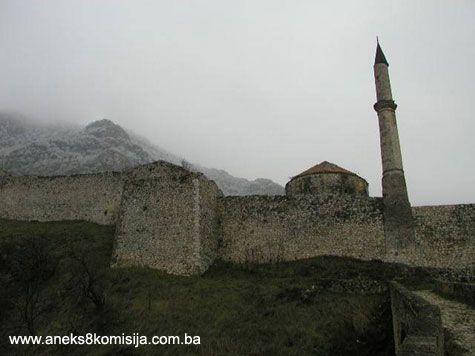
The old Travnik fort lies on a rocky ridge that forks off from Bukovica, a spur of Mt. Vlašić. To the east of the fort is the fast-flowing Šumeće brook, and to the west a brook named Hendek. The terrain on which the fort was buiilt slopes down from north to south.
The fortress occupied the largest area possible given the terrain, with no further expansion possible. It covers an area of approx. 11000 m2 . The northernmost point, on which a bastion projecting out from the rest of the fortress was located, was also the weakest point naturally, as is the entire north side. According to the information provided by previous researchers, there was a prehistoric structure on this site. At one time the site of the fortress was known as Garbun, but this name has long been forgotten (Petrović, 1931, 12). At the foot of the town, over the main Travnik-Sarajevo road, are the ruins of the Hasanpašić tower. This tower was presumably a separate part of the old fort, which lost its strategic importance with the passage of time, and was later turned into a bey's tower.(1)
The fortress in Travnik is an irregular pentagon in ground plan. To the west, from which it is accessible, there is also a projecting almost square half-tower alongside the curtain wall and bastion on the northern corner; this tower defended the main entrance to the fort. The east rampart has three projecting, polygonal half-towers; of these, the north and south towers have been further reinforced by buttress walls. Eighteen loopholes have survived between the south and the central tower. These half-towers defended the direct access to the ramparts from the east.
Three stone outlets for water were found on the outside of the ramparts, at a depth of 3 to 4 metres. The original level of the lower bailey must therefore have been at least two metres below the present level. There was a secret passageway by the north tower. In 1931 most of the east rampart collapsed, and was rebuilt (Mazalić, 1948, 158).
The north ramparts are 36 metres long. The walls are as much as 2.7 metres thick in places. The breastworks of the north ramparts are 0.80 metres thick. The additional inner part of the wall is 1.90 m thick. A stone stairway led alongside this, all the way from the endmost north half-tower on the east rampart to the projecting bastion. The ramparts to the south of the fortress end in zigzag lines.
Taken as a whole, the old Travnik fort was built at a time when firearms were in use, and is a typical artillery fortress.
Within the curtain wall, there is an older, mediaeval complex (E1) in the north-western part of the fortress. There is another bailey in the upper level of the fort, in the south-western part, extending towards the north rampart (E3). Another bailey is located in the lower level of the fort, along the entire length of the eastern part of the fortifications (E2).
The easiest access to the old fort is from the west, across the stone bridge over the Hendek brook. The bridge is round-arched, with a span of 6 m and a height of approx. 11 m above water-level. The bridge is approx. 3.2 m wide. The parapet is composed of tufa and is approx. 90 cm in height. There is a small plateau level area between the bridge and the entrance to the old fort.
The entrance to the fort is mid-way along the southern part of the west rampart. It is round-arched. The old, low gate was at some time replaced by a new, taller one.
Steps lead from the entrance into the upper bailey in the south-western part of the fortress (E3). To the south of the steps are the remains of a building (G), erected during the Austro-Hungarian period.
To the north of the entrance steps is the Beyazit II mosque (F). Stairs in the north-eastern corner of the mosque lead to a polygonal tower (D) and the small bailey (E1) which is where the mediaeval part of the fort begins.
Those who have explored the fortress have been unable, on the basis of what has been discovered so far, exactly how far the mediaeval fort extended. The fact that it came into being in the mediaeval period can be seen from the prominent position of the fort in pre-firearms days. Bojanovski is of the view that the mediaeval fort included the small bailey (E1) and tower (D), and perhaps even the entire area covered by the fortress (Bojanovski, 1977, 2, 5-9). It certainly included the north-western part of the fort, and consisted of:
- defensive tower (A),
- courtyard with the palace beneath the tower (B).
In the northern part of the fort, at its highest point, there was once a round tower, which was subsequently turned into a ten-sided bastion, next to which a water cistern was later built. Excavations revealed that the mediaeval tower had survived to a height of 8 metres. It is 4.5 m in diameter. The exact thickness of the tower wall has not been established. The inner tower wall was found to be smoothly plastered and without signs of having being used (Lozić, 1962, 176). The mediaeval tower was later turned into the ten-sided bastion with sloping sides. The south side of the bastion is slightly rounded and extended by a low terrace with a built-in water cistern. The sides of the bastion are 10 m in height, and its width varies from 3.5 to 4 m at the base, and from 2.4 to 3 m at the top. The outer revetment was of quarry stone or rough-cut stone, with ties to ensuring the stability of the walls consisting of transverse wooden beams (hatula), which suggests mediaeval construction. The edges of the sides were faced with cut stone blocks. The infill of the bastion (the mediaeval defensive tower) consisted of a mixture of quarry stone and lime mortar. The bastion platform, used as a firearms emplacement, has a diameter of 10-12 m. It was originally built with a wall 3-4 m in height and 0.90 m thick. The entire platform was roofed over. Circular apertures framed with tufa blocks were pierced in that part of the wall. The cannon openings, of which the lower parts can still be seen, were 0.80 m in diameter. The bastion platform was reached via steps built against the north wall. At the top of the steps was a round-arched gateway with tufa blocks. The height of the gateway to the apex of the arch is 2.15 m, and the gap between the door jambs is 1.40 m wide. The bastion platform is some 16 m higher than the lowest, south-east corner of the fortress.
A terrace was built against the south wall of the bastion, about 2.5 m below the level of the bastion platform. The terrace was surrounded by a wall on all sides, and probably roofed, since a walled-up opening was found on the west wall. This suggests that the terrace was formerly lower. An oval cistern with an elliptical tufa vault (the ellipse bisected lengthwise) was built in under the terrace. The opening through which the water was drawn, measuring 0.6 x 0.5 m, was in the middle of the arch. The south wall of the cistern was breached during World War II. It is approx. 2.5 m thick. The longer axis of the base of the cistern measures 4.7 m and the shorter 2.5 m. The cistern is 3 m in height from its base to the apex of the vault. Calculating from these measurements, the cistern would have held up to 2000 litres of water.
To the south of tower (A) is a courtyard, (B), measuring approx. 28 x 17 m. Prior to the 1973-74 excavations, it had become filled with earth to a height of 6 m below the terrace with the built-in reservoir. The west wall of the courtyard is 3.20 m thick and the east wall 1.80 m. The east wall is 4.5 m in height, and has another rampart built against it on the outside, with a height of 5.5 m, in which all 18 loopholes have survived.
A palace of the royal court was built in the courtyard, partly incorporated into the defensive architecture of the fortress. The walls of the palace are 1.2 m thick,and built mainly of chiselled pieces of tufa and local limestone with lime mortar as binder. The layout of this palace is similar to that of the Upper Palace in Bobovac (dating from the mid 14th century). Part of a window lintel from the interior of the palace has survived, revealing that the window was in the form of a Gothic bifora, decorated with a medallion featuring a human head and a separate plant motif.
In addition to this, two stone consoles were found during the excavations. The researcher, P. Anđelić, hypothesized that this palace could have belonged to the tepćija (land-agent) Batalo, who lived in the late 14th and early 15th centuries (Anđelić, 1984, 465). All this, along with the layout of tower D, and the fact that the quarter below the west slope of the fortress was known as Varoš, suggests that it dates from the mediaeval period, probably the end of the 14th century (Bojanovski, 1977, 3).
A smaller building, measuring 9 x 4.6 x 4.3 m, stands in the southern part of the courtyard. It was stone built, with a tufa vault. The north wall of the building is larger on account of the pressure from the piled up earth in courtyard (B). The original entrance to the building, measuring 1.4 x 0.70 m, is still in place, but the small window in the east wall has been walled up. After 1878, two windows with sides of 1 m were pierced in the south wall. The building was used as an armourer’s shop or casemate (Mazalić, 1948, 152-153; Bojanovski, 1977, 6-7).
A sixteen-sided polygonal tower (D) stands at the centre of the entire defensive system. Bojanovski notes that it has all the features of a “tower on a rampart” (Mauerturm) of an advanced mediaeval fort. Since there is no means by which the tower can be archaeologically investigated because its base, which is 1 m above the natural rock base, has been concreted, he assumed from its position that a mediaeval tower of some kind previously stood on the same spot (Bojanovski, 1977, 7). The north-west part of the tower is buried in the bailey to a height of one storey. The walls of the tower are 11 m in height, with the roof that was reconstructed at a later date. Prior to the conservation and restoration works, the topmost part of the wall, with a height of 1 m, was brick-built. The tower consists of a ground floor and upper storey. Although it has a an almost regular sixteen-sided ground plan, it has been distorted on the inside by heavy-handed interventions. The walls of the tower, which are 1.5 m thick, are of cut stone, well laid and bonded with narrow joints. The edges are composed of tufa blocks. The ceiling partitions and floors were made of wood. The entrance to the tower is to the north, opposite the cannon loopholes. The entrance is 1.45 m high and 0.50 wide, increasingn on the inside to a height of 1.85 m and a width of 1.50 m. The door is arched. There are six cannon openings on the ground floor, facing south-east, and measuring 0.76 m. On the first floor there is one on each side, a total of 16, measuring 0.65 x 0.55 m. Later all these cannon openings were turned into loopholes, by the skilful insertion of tufa blocks between which a slit only a few centimetres wide and up to 0.50 m high was left open. During World War I and II one opening on the ground floor and four on the first floor were reopened.
The tower has a wooden sixteen-sided roof clad with tiles.
A well-preserved water cistern was discovered to the west of tower (D), probably dating from the Austro-Hungarian period. It was constructed of tufa and cement, and is 3 m long, 1.65 m wide and 2 m deep. It has two square openings, one by the tower, and the other at the opposite end. The first, close by the tower, is narrow and could have been simply for ventilation, with the one at the opposite end used to enter the cistern. The names of late 19th century Austrian soldiers are scrawled on the walls of the cistern (Lozić, 1962, 177). Mazalić notes that there was a well or čatrnja to the south of tower (D), marked on a map dating from 1882 (Mazalić, 1948, 154).
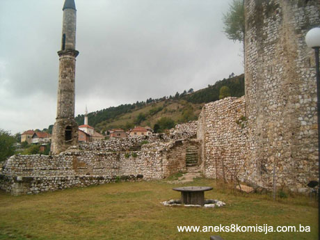
To the north of the entrance steps on the upper plateau, by the west wall, are the remains of the Bayezid II mosque. The building was roughly rectangular in ground plan, measuring approx. 12 x 7.5 m. All that survives of the mosque walls are stone walls with a height of approx. 80 cm. The minaret of the mosque was built into the west rampart of the fort. The mosque was pulled down after World War I, having fallen into a state of dilapidation. The minaret is fairly well preserved, and the workmanship and the way the individual stone blocks are bonded suggest it was the work of very competent masons. Local tradition has it that they were from Dubrovnik. The šerefe (balcony) of the minaret had no decorations and is now in a state of almost complete ruin.
It is not yet entirely clear whether the part of the plateau between the southern mosque wall and tower D (area E1) belonged to the mediaeval part of the fort. This area is entered through a small arched gateway beyond which rise small steps. The gateway is between the west wall that runs from tower D towards the half-tower in the west rampart, right by the north wall of the mosque (Mazalić, 1948, 156; Bojanovski, 1977, 2).
To the south of the main access steps, in the south-western part of the plateau (E3), are the ruins of an Austrian building (G). A building (H) dating from the mid 19th century stood on the eastern edge of this plateau. This building is now completely in ruins. It was reached via steps leading to the lower bailey (area E2). The east wall of plateau E3 also enclosed the area below the mediaeval part of the fort, all the way to the north curtain wall. The wall now ends roughly at mid-point.’
The lower parts of the walls of some mediaeval building measuring 14.70 x 12.80 survive in the south corner alongside the ramparts (Mazalić, 1948, 156). These walls have been conserved. Building (J), of which vestiges are still visible on the surface, stood in the north-east corner. A barrel-vaulted secret passageway 1.5m in height and 1 m in width, built of cut tufa blocks, led from the walls of the building of which the foundations have survived (J) steeply through the ramparts, probably by way of steps, and was 2 m above the outside level of the terrain. It was later walled up on the outside (Mazalić, 1948, 156).
It proved impossible to determine from the archaeological investigations carried out whether, in addition to the area occupied by buildings A, B and C and bailey E1, the mediaeval fortcovered the entire site on which the fortress was later built during Ottoman times. The present-day appearance of the fort hascome about by gradual alterations and extensions, reinforcements and adaptations of earlier structures. Much if not all of the present architecture dates from the Ottoman period.
Bojanovski is of the view that as well as the nucleus of the mediaeval fortress from buildings A to C, it also extended to the area up to the south wall of the mosque, i.e. area E1. Whether there was a mediaeval tower before the sixteen-sided tower D was built in Ottoman times remains an open question. The construction, or existence, of the mediaeval part of the fort is dated to the late 14th and first half of the 15th century (Bojanovski, 1977, 1,2).
The sixteen-sided tower (D) is typical of buildings dating from the Ottoman period, an advanced type of the oldest artillery towers, up to four storeys in height, built in the frontier regions between the Hungarian Kingdom and the Ottoman Empire at the beginning of the second half of the 15th century (Popović, 1989, 106). By the 1480s, polygonal bastions with sloping, lower outer walls, like the north projecting bastion (A), were already being built. Popović dates the erection of these two structures to the second half of the 15th century and Bojanovski to the 16th. Both date the construction of the retaining wall with 18 loopholes, to the east of the original nucleus, to the same period as these two buildings (Bojanovski, 1977, 4; Popović, 1989, 104). There is nothing to indicate a more precise dating of the rebuilding of the fort. The entire curtain wall was built during the Ottoman period.
The casemate and water cistern beside bastion (A), and the projecting polygonal towers on the west and east ramparts, were probably built in the 17th or early 18th century, since the Ottoman Empire was on the offensive during the 16th century and had no need to build such defences. Only after the Ottomans defeat outside the walls of Vienna in 1683 did it become necessary to build kazamats for defensive purposes. All this additional building was designed to make Travnik as solid a stronghold as possible at a time when its political power was increasing and when artillery fire was also becoming more effective, while at the same time there was a growing threat from the Empire’s neighbour to the north (Bojanovski, 1977, 10-11).
3. Legal status to date
Pursuant to a Ruling by the National Institute for the Protection of Cultural Monuments and Natural Rarities of BiH Sarajevo no. 724/50, of 16 June 1950, the site was placed under state protection, and pursuant to a Ruling by the Institute for the Protection of Cultural Monuments of BiH Sarajevo, no. 02-794-3, of 18 April 1962, the site of the old fort and the bridge over the Hendek outside it, in Travnik, state property, land register entry no. IV-312-316, 438-441, was placed under state protection and entered in the Register of Immovable Cultural Monuments. This Decision came into force on 24 October 1962.
The 1980 Regional Plan of Bosnia and Herzegovina listed the property as a Category II cultural and historical property.
The property is on the Provisional List of the Commission to Preserve National Monuments of Bosnia and Herzegovina under the title Old Travnik Fort and Fortress in Travnik, nos.. 632 and 646 respectively.
4. Research and conservation and restoration works
Archaeological excavations
- 1969 – Archaeological excavations headed by Marko Vega;
- 1973-1974 – Archaeological excavations headed by Ivo Bojanovski and Pavle Anđelić (a detailed report enclosed in the Commission file);
- 1985-1986 – Zdenko Žeravica, excavation in the area of the main tower (A) (to our knowledge a detailed report on the excavations is held in the Federal Institute for the Protection of Cultural Monuments of FBiH).
Conservation and restoration works
- Around 1900 – Austro-Hungarian authorities carried out works on the ramparts facing Plava voda;
- 1953 – The fort was handed over to the care of the Regional Museum in Travnik;
- 1953 – Completion of clearing the site and certain conservation and restoration works to enable access to visitors (source – file of the site held by the Institute for Protection of Monuments in BiH); the fort was landscaped with the sole purpose of making a belvedere and opening a restaurant (detailed report);
- 1957 – Works on the access bridge – erection of a tufa and lime mortar parapet to replace the wooden railing;
- 1958 – Reconstruction of the roof frame and cladding on the polygonal tower;
- 1970 – Larger scale conservation works on the old fort – the western fortress walls and a part of the wall above the Hendek brook were repaired;
- 1977 – Large scale conservation works on the old fort – repairs to walls, repairs to polygonal tower, roof clad with tiles, conservation of upper zones of wall facing by making concrete slabs, palace area reconstructed for the purpose of theatre performances; bastion covered with soil;
- 1998 – The Institute for the Protection of the Cultural, Historical and Natural Heritage of BiH conducted an inspection of the site, which served as the basis for planning a reconstruction project to repair the damage caused by long-term lack of maintenance.
- 2000 – The old fort cleared of self-sown vegetation, repair works on the damaged bridge – works included dismantling the damaged parapet wall, repairing the foundation and replacing the blocks; repair works on part of the rampart north of the minaret were also carried out;
- 2001 – Part of the wall below the polygonal tower repaired;
- 2002 – Repairs to the access portal and arch of the door, as well as approx. 60 m of the ramparts;
- 2003 – As a part of the project “The Living Heritage“, cultural and entertainment events took place in the courtyard area –open air cinema, household pet shows, etc.
5. Current condition of the property
Conservation and restoration works have been carriedout on the old Travnik fort, at various times, financed by the former Republic Fund as well as resources allocated to the Institute for the Protection of the Cultural, Historical and Natural Heritage of Bosnia and Herzegovina, which also initiated archaeological excavations on the site of the fortress and designed the projects for the revitalisation, conservation and restoration of the fortress. The condition in which this cultural and historic monument is now would be much worse if it were not for the employees of the Regional Museum in Travnik, who have been caring for the property since 1953.
It should also be noted that more than twenty-five years have passed since major conservation and restoration works were carried out on the fortress, so that quite understandably there is visible damage to the structure caused by the lack of resources for routine maintenance. This damage includes the erosion by rainfall of the binder medium from the joints, causing bulges to appear in the wall mass and, subsequently, stone blocks falling away.
Access bridge
- The bridge is in good condition following the latest interventions;
- There is self-sown vegetation on the cobbled walkway.
Damage to the ramparts
- To the north of the minaret and the entrance into the old fort, there is damage to the crown of the west wall of the fort resulting from the binder medium being washed out by rain and numerous stone blocks falling to the ground in consequence. The endangered area of the rampart at this point is approx. 10 m2;
- At the same place, but lower down, the stone revetment of the wall is damaged due to the binder medium being washed out;
- The south-eastern inner parts of the ramparts are at risk of deterioration;
- The east outer wall of the rampart (facing Plava voda) is at risk of deterioration;
- The east inner rampart is badly damaged due to washing-out of the binder medium and stone blocks falling as a result. There is self-sown vegetation on the upper surface. The endangered area covers approximately 2000 m2.
Defensive tower – ten-sided bastion
- There is visible damage to the stone revetment on the north-west side at the base of the structure, as well as on the tufa quoins. The endangered area covers approx. 12 m2;
- The inner circular ring of the tower, representing the remains of the mediaeval part of the structure, is overgrown with wild vegetation,
- The base of the circular part of the tower is covered with loose stone and garbage;
- There is visible damage to the stone revetment on the north and north-east sides;
Sixteen-sided polygonal tower
- The roof structure of the polygonal tower is damaged and is leaking badly, affecting the interior;
- The components of the wooden roof structure are affected by fungus and rot
- The floor joists are at risk of rot;
- The walls of the polygonal tower are overgrown with wild vegetation.
Casemate
- The absence of a waterproof layer on the roof has resulted in rainwater starting to leak into the arch structure;
- Due to deterioration of the binder medium, stone blocks began to fall from the eastern part of the arch;
- Due to deterioration of the binder medium and the presence of a large amount of water, the entire length of the south revetment wall has collapsed;
- The roof is badly overgrown with wild vegetation;
- The metal elements are exposed to corrosion;
- The arched lintel and the door that lead from the plateau outside the polygonal tower and casemate palace and defensive tower have begun to collapse.
Minaret
- Long-term lack of maintainance has resulted in deterioration of the structure of the minaret šerefe (balcony);
- Wind has caused the roof of the minaret to shift by about 30 cm to the north;
- The staircase in the minaret is badly damaged due to erosion;
- The entrance into the minaret has been temporarely closed due to safety concerns.
Stairways
- The steps leading to the defensive tower in the northern part of the fortress aare damaged and are closed to visitors due to the absence of a protective railing;
- The parapet wall located on the northern side has been damaged by washing-out of the binder medium. The surface area of the wall that is at risk is not known because of the difficult access;
Building dating from the Austro-Hungarian period
- The absence of the roof structure means that the building is exposed at all times to the adverse effects of the elements;
- There is a risk of its complete collapse on the east and south sides.
There is a considerable quantity of water in the structure of the old fort, as evidenced by the extensive presence of vegetation within the property. Weeds growing in the open spaces absorb the excess water and thereby relieve the pressure on the large wall surfaces.
A summer stage has been set upin the courtyard of the old fort.
6. Specific risks
- Unfavourable weather conditions leading to parts of the walls collapsing;
- Presence of large quantities of water;
- Self-sown vegetation
- Failure to carry out routine maintenance.
III – CONCLUSION
Applying the Criteria for the adoption of a decision on proclaiming an item of property a national monument (Official Gazette of BiH nos. 33/02 and 15/03), the Commission has enacted the Decision cited above.
The Decision was based on the following criteria:
A. Time frame
B. Historical value
C. Artistic and aesthetic value
C. i. quality of workmanship
C.iii. proportions
C.iv. composition
D. Clarity (documentary, scientific and educational value)
D.ii. evidence of historical change
D. iv. evidence of a particular type, style or regional manner
E. Symbolic value
E.v. significance for the identity of a group of people
F. Townscape/ Landscape value
F.ii. meaning in the townscape
F.iii. the building or group of buildings is part of a group or site
G. Authenticity
G.v. location and setting
G.vii. other internal and external factors
I. Completeness
I.iii. completeness
I.iv. undamaged condition
The following documents form an integral part of this Decision:
- Copy of cadastral plan,
- Proof of title,
- Photo-documentation:
- Graphic 1876. Arthur Evans
- Photographs from http://www.plavavoda.com
- Photographs from documentation of the Regional Museum in Travnik
- Photographs of archaeological excavations from documentation of the Regional Museum in Travnik
- photodocumentation of the Commission to Preserve National Monuments of BiH
- Drawings.
Project for the revitalization of the old Travnik fort (Institute for the Protection of Monuments of BiH) – photographs
- Current condition: ground plan, scale 1:100
- Façade scale 1:100
- Cross-section scale 1:100
- Condition as per project – ground plan, scale 1:100
- Façade scale 1:100
- Cross-section scale 1:100
Bibliography:
During the procedure to designate the monument as a national monument of Bosnia and Herzegovina, the following works were consulted:
1931 Petrović, Jozo, S arheologom kroz Travnik (Visiting Travnik in the Company of an Archaeologist), Zagreb, 1931.
1948 Mazalić, Đoko, Travnik i Toričan (prilog bosanskoj arhitekturi srednjeg vijeka) (Travnik and Toričan [a Supplement to the Bosnian Architecture of the Middle Ages]), Jnl. of the National Museum in Sarajevo, new series, volume VIII, Sarajevo, 1948, 145-166.
1952 Kreševljaković, Hamdija, Prilozi povijesti bosanskih gradova pod turskom upravom (Contributions to the History of the Bosnian Towns Under the Turkish Rule), Prilozi za orijentalnu filologiju i istoriju jugoslovenskih naroda pod turskom vladavinom (Supplements to Oriental philology and the history of the Yugoslav peoples under Turkish rule), no. II/1951, Oriental Institute in Sarajevo, Sarajevo, 1952, 119-184.
1953 Kreševljaković, Hamdija, Stari bosanski gradovi (Old Bosnian Forts), Naše starine I (Our Antiques I), Sarajevo, 1953, 7-45.
1957 Kreševljaković, Hamdija and Kapidžić, Hamdija, Podaci o tvrđavama u Derventi i Travniku iz početka XIX stoljeća (Data on the Fortresses in Derventa and Travnik from the early 19th century), Naše starine IV (Our Antiques IV), Sarajevo, 1957, 205-212.
1957 Vego, Marko, Naselja bosanske srednjovjekovne države (Settlements of the Mediaeval Bosnian State), Sarajevo, 1957.
1961 Kreševljaković, Hamdija and Korkut M. Derviš, Travnik u prošlosti 1464-1878 (Travnik in the Past 1464-1878), Regional Museum in Travnik, Travnik, 1961.
1962 Lozić, Stipe, Konzervatorski radovi na starom gradu Travniku (Conservation Works on the Old Fort in Travnik), Naše starine VIII (Our Antiques VIII), Sarajevo, 1962, 175-178.
1964 Ćirković, Simo, Istorija srednjovjekovne bosanske države (The History of the Mediaeval Bosnian State), Beograd, 1964.
1974 Bojanovski, Ivo, Dolabelin sistem cesta u rimskoj provinciji Dalmaciji (The Dolabela Road System in the Roman Province of Dalmatia), The Academy of Science and Art of Bosnia and Herzegovina, Djela (Works), book XLVII, Sarajevo, 1974.
1977 Bojanovski, Ivo, Stari grad Travnik-arheološka i kasteološka osnova (The Old Travnik Fort: Archaeological and Fortificational Background); a detailed report from the Republic Institute for the Protection of Cultural and Natural Heritage of Bosnia and Herzegovina, excavations 1973, Sarajevo, 1977.
1977 Mujezinović, Mehmed, Islamska epigrafika (Islamic Epigraphics), book II, Veselin Masleša, Sarajevo, 1977.
1978 Kovačević-Kojić, Desanka, Gradska naselja srednjovjekovne bosanske države (Urban Settlements of the Mediaeval Bosnian State), Veselin Masleša, Sarajevo, 1978.
1979 Čelebija, Evlija, Putopis (Travel Chronicle), ed. Hazim Šabanović, Veselin Masleša, Sarajevo, 1979.
1984 Anđelić, Pavao, Doba srednjovjekovne bosanske države (The Time of the Mediaeval Bosnian State), In: Kulturna istorija Bosne i Hercegovine od najstarijih vremena do pada ovih zemalja pod osmansku vlast (Cultural History of Bosnia and Herzegovina from ancient times to the fall of these lands under Ottoman rule), Veselin Masleša, Sarajevo, 1984, 435-587.
1984a Anđelić, Pavao, Visoko i okolina u srednjem vijeku (Visoko and Its Surroundings During the Middle Ages), in: Visoko i okolina kroz historiju 1 (Visoko and its Surroundings Throughout History 1), the Visoko Municipality, Visoko, 1984, 101-310.
1987 Žeravica, Zdenko, Travnik, Stari grad (Srednjovjekovni grad) (Travnik, the Old Fort – a Mediaeval Fort), Archaeological survey 1986, Ljubljana 1987, 156.
1989 Popović, Marko, Uticaj pojave topova na razvoj odbrambenih sistema srednjovjekovnih gradova u Bosni (Influence of the Emergence of Cannon on the Development of Defensive Systems in the Mediaeval Forts in Bosnia), Collected Papers of the International symposium „Bosnia and Herzegovina in the Course of the Historical and Cultural Movements in the Southeast Europe“, Sarajevo, 6-7 October 1988, The National Museum of Bosnia and Herzegovina, Sarajevo, 1989, 99-110.
1994. Klaić, Nada, Srednjovjekovna Bosna, politički položaj bosanskih vladara do Tvrtkove krunidbe (1377.g.) (Mediaeval Bosnia, the political position of Bosnian rulers up to Tvrtko’s coronation [1377])
1995 Popović, Marko, Srednjovjekovne tvrđave u Bosni i Hercegovini (Mediaeval Fortresses in Bosnia and Herzegovina), the Collection of the History of Bosnia and Herzegovina 1, the Serbian Academy of Science and Art, Department for the History of Bosnia and Herzegovina, Belgrade, 1995, 33-55.
- Documentation from the Institute for the Protection of the Cultural, Historical and Natural Heritage of BiH
- Documentation from the Regional Museum in Travnik
- Documentation from the BiH Archives
- Documentation and library of the Bosniac Institute in Sarajevo
(1) According to local tradition, this tower could be associated with the incursions by Vuk Jajčanin into Ottoman territory as far as Sarajevo in 1480 (Mazalić, 1948, 146).
|