Status of monument -> National monument
Pursuant to Article V para. 4 Annex 8 of the General Framework Agreement for Peace in Bosnia and Herzegovina and Article 39 para. 1 of the Rules of Procedure of the Commission to Preserve National Monuments, at a session held from 25 to 31 January 2005, the Commission adopted a
D E C I S I O N
I
The historic monument of the Bridge on the River Žepa is hereby designated as a National Monument of Bosnia and Herzegovina (hereinafter: the National Monument).
The National Monument is located in the area of the Municipality of Rogatica, town of Žepa, Republika Srpska, Bosnia and Herzegovina.
The provisions relating to protection measures set forth by the Law on the Implementation of the Decisions of the Commission to Preserve National Monuments, established pursuant to Annex 8 of the General Framework Agreement for Peace in Bosnia and Herzegovina (Official Gazette of Republika Srpska”, No. 9/02) shall apply to the National Monument.
II
The Government of Republika Srpska shall be duty bound to ensure and provide the legal, scientific, technical, administrative and financial measures necessary to protect, conserve, display and rehabilitate the National Monument specified in Clause I of this Decision.
The Government of Republika Srpska shall be duty bound to provide the resources required to draw up and implement the necessary technical documentation for the protection, preservation and presentation of the national monument.
The Commission to Preserve National Monuments of Bosnia and Herzegovina shall determine the technical requirements and secure the funds for preparing and setting up signboards with the basic data on the monument and the Decision to proclaim the property a National Monument.
III
To ensure the on-going protection of the National Monument, Zone I and Zone II are hereby established:
Protection Zone I comprises the bridge and the area designated as c.p. No. 1078, 1080, c.m. Žepa and c.p. No. 26, 30 and 41. c.m. Vratar, Municipality Rogatica.
The following protection measures shall apply in this zone:
- all works are prohibited other than conservation and restoration works, and works designed to display the monument, with the approval of the Ministry responsible for regional planning of Republika Srpska and under the expert supervision of the heritage protection authority at the level of Republika Srpska (hereinafter: the heritage protection authority);
- traffic over the bridge is prohibited;
- the dumping of waste is prohibited.
Protection Zone II comprises a strip with a radius of 200 metres measured from the centre of the bridge.
The following protection measures shall apply in this zone:
- the extraction of stone and the exploitation of other natural resources is prohibited;
- the dumping of waste is prohibited;
- activities that during operation could give rise to adverse effects on the protected site (air pollution, noise, vibration) are prohibited.
The Government of Republika Srpska is duty bound in particular to ensure the implementation of the following measures:
- draw up a programme to determine the current condition of the property
- conduct a geodetic survey of the current condition
- examine the materials and condition of the structure
- analyse available information on the bridge
- conduct a preliminary structural analysis
- draw up a project for the repair, restoration and conservation of the bridge.
The Rehabilitation, Restoration and Conservation Project shall consist of:
- a structural analysis of the terrain and the structure of the bridge with measures to make good the terrain and the foundations on which the structure of the bridge rests, with repairs to the abutments of the bridge
- repairs to damage to the barrel with lightweight movable scaffolding, together with cleaning the joints and filling with lime mortar;
- repairs to the upstream and downstream wing walls;
- repairs to the damage to the string courses and parapet (korkaluk) of the bridge;
- clearing the surroundings of the bridge, together with the removal of self-sown vegetation;
- clearing the bridge and removing self-sown vegetation from the structure.
IV
All executive and area development planning acts not in accordance with the provisions of this Decision are hereby revoked.
V
Everyone, and in particular the competent authorities of Republika Srpska, urban and municipal services, shall refrain from any action that might damage the National Monument specified in Clause I of this Decision or jeopardize the protection thereof.
VI
The Government of Republika Srpska, the Ministry responsible for regional planning in Republika Srpska, the heritage protection authority, and the Municipal Authorities in charge of urban planning and land registry affairs, shall be notified of this Decision in order to carry out the measures stipulated in Articles II to V of this Decision, and the Authorized Municipal Court shall be notified for the purposes of registration in the Land Register.
VII
The elucidation and accompanying documentation form an integral part of this Decision, which may be viewed by interested parties on the premises or by accessing the website of the Commission (http://www.aneks8komisija.com.ba/)
VIII
Pursuant to Art. V para 4 Annex 8 of the General Framework Agreement for Peace in Bosnia and Herzegovina, decisions of the Commission are final.
IX
On the date of adoption of this Decision, the National Monument shall be deleted from the Provisional List of National Monuments of Bosnia and Herzegovina (Official Gazette of BiH no. 33/02, Official Gazette of Republika Srpska no. 79/02, Official Gazette of the Federation of BiH no. 59/02, and Official Gazette of Brčko District BiH no. 4/03), where it featured under serial no. 492.
X
This Decision shall enter into force on the date of its adoption and shall be published in the Official Gazette of BiH.
This Decision has been adopted by the following members of the Commission: Zeynep Ahunbay, Amra Hadžimuhamedović, Dubravko Lovrenović, Ljiljana Ševo and Tina Wik.
No:07.2.2-969/03-7
25. January 2005
Sarajevo
Chair of the Commission
Amra Hadžimuhamedović
E l u c i d a t i o n
I – INTRODUCTION
Pursuant to Article 2, paragraph 1 of the Law on the Implementation of the Decisions of the Commission to Preserve National Monuments, established pursuant to Annex 8 of the General Framework Agreement for Peace in Bosnia and Herzegovina, a “National Monument” is an item of public property proclaimed by the Commission to Preserve National Monuments to be a National Monument pursuant to Articles V and VI of Annex 8 of the General Framework Agreement for Peace in Bosnia and Herzegovina and property entered on the Provisional List of National Monuments of Bosnia and Herzegovina (Official Gazette of BiH no. 33/02) until the Commission reaches a final decision on its status, as to which there is no time limit and regardless of whether a petition for the property in question has been submitted or not.
The Commission to Preserve National Monuments issued a Decision to add the bridge on the River Žepa to the Provisional List of National Monuments of Bosnia and Herzegovina, numbered as 492.
In accordance with the provisions of the law and pursuant to Article V of Annex 8 and Article 35 of the Rules of Procedure of the Commission to Preserve National Monuments, the Commission proceeded to carry out the procedure for reaching a final decision to designate the property as a National Monument.
II – PROCEDURE PRIOR TO DECISION
In the procedure preceding the adoption of a final decision to proclaim the property a national monument, the following documentation was inspected:
- Data on the current condition and use of the property, including a description and photographs, data on war damage if any, data on restoration or any other works on the property if any, etc;
- Land register entry and details of ownership
- Historical, architectural and other documentary material on the property, as set out in the bibliography forming part of this Decision.
The findings based on the review of the above documentation and the condition of the property are as follows:
1. Details of the property
Location
On the River Žepa, the left tributary of the River Drina, there are two stone bridges dating from the Ottoman period – one constructed in the immediate vicinity of the source of the river, the other some ten metres above the mouth of the river, on the road that forked off the old Istanbul road in Višegrad and followed the left bank of the Drina downstream.
Until 1966, the bridge was located at the mouth of the river; it was then dismantled and rebuilt when the Bajina Bašta hydro-power plant was constructed on the location. The bridge’s new location is approx. 500 metres from the town of Žepa, not far from Redžeb-pasha’s Tower, built at approximately the same time.
Historical Information
There is no information in older manuscripts and travelogues on the builder and the date when the bridge on the Žepa was built, nor is there any surviving inscription with tarikh on the bridge that might provide precise data on the date and the builder of the bridge.
As is true of most buildings in this part of the world, many folk legends and myths have been preserved(1). One of these legends recounts that the bridge was built by one of the disciples of Mimar Sinan, the master-builder of the Višegrad Bridge, who wanted to surpass his master’s work(2). Another legend concerns Yusuf the Vizier, who was born in this part of the world, and an Italian architect who was commissioned to build this bridge(3).
The following hypotheses may be deduced from an analysis of the first legend:
- the bridge on the river Žepa was built immediately after the Mehmed-pasha bridge Sokolović in Višegrad;
- the bridge on the river Žepa was built by a disciple of the master-builder of the bridge in Višegrad, Mimar Sinan;
The first of the two items of information cited above fits the hypothesis that the bridges were built solely as structures whose construction was financed by the state, through its officials in the field. They were built solely with the purpose of improving the system of communications in the Empire. In such the context, the Višegrad bridge is the key bridge that connected Bosnia and Herzegovina with the rest of the Empire. Its construction created the need for new bridges on both the main and the auxiliary roads leading to it, so that almost simultaneously, as part of the same project, the bridges were built on the Žepa as well as the Kozija Ćuprija (Goat’s Bridge) in Sarajevo(4).It is possible, therefore, or even probable, that the founder of this bridge was also Mehmed-Pasha Sokolović, and that it may realistically be dated to the last quarter of the 16th century (Ćelić, Mujezinović, p. 203).
As for the hypothesis that it was built by one of the disciples of Sinan, this too seems realistic, since Sinan (1490 – 1588) was already of advanced years when the bridge was built(5). Documents concerning Sinan contain the name of a certain Mustapha-čauš, a man of Sinan’s confidence, so it may be assumed that the entire realisation of the bridge on the river Žepa was most probably entrusted to him (Ćelić, Mujezinović, p. 203) (6).
The architectural characteristics of the bridge and the quality of work indicated, and still indicate, although the bridge has been moved to a new location and is now in completely new topographic conditions, that this is an outstanding architectural complex and the work of a master-builder of great skill. It is impossible in this case that the builder originated from the local community. Judging from the boldness of the structure, the builder attended the best of architectural schools and mastered the most advanced architectural skills of his day. Some formal elements, such as the line of the arch, the method of masonry used, etc. are very similar to details to be seen on the Mehmed-Pasha Sokolović bridge in Višegrad, which suggests that the builders of these two bridges could indeed belong to the same school and that both were built by the end of the 16th century.
As already noted, there are no older documents on the erection of the bridge. The bridge was, however, commented upon by numerous travel writers, artists and travellers who visited this region(7).
The bridge on the mouth of the river Žepa was not used for centuries. Far from inhabited places and roads, it was thanks to the way it was built that the bridge resisted the effects of time. However, the construction of the Bajina Bašta hydro-power plant sealed its fate, just as it jeopardized the Višegrad bridge and other monuments of the architectural heritage in that region. The artificial reservoir serving the power plant raised the water level by 10 metres above the highest point of the bridge. The project of a future reservoir for Bajina Bašta, known as Perućac, in Serbia and Montenegro, has from the very outset posed a risk to the entire architectural heritage of the region. As early as in 1960, the BiH Institute for the Protection of Monuments established contacts with the investor of the construction of the dam, in order to reach agreement concerning protection measures to be taken with regard to this and other monuments. In this specific case, apart from the authorities being willing to give up building the reservoir, the only solution was to reconstruct the bridge on a site that would not be flooded. In 1960, by agreement with the investor, a reconnaissance of the terrain was conducted, on the basis of which a special project was designed and the costs were estimated. At meetings held on 18 November 1964 and 15 April 1965 and, finally, at the meeting held on 25 February 1966, the following conclusions were reached:
- The bridge must be preserved and reconstructed on a site below the tower in Žepa;
- Work must begin as soon as possible on the dismantling and transfer of the material to the new location, followed by reconstruction works;
- The works shall be undertaken by the BiH Institute for the Protection of Monuments or a sub-contractor shall be identified.
In the summer of 1966 the bridge was dismantled and the material was moved to a point higher than the highest level of the reservoir. In 1967, the bridge was rebuilt, and in 1968 it was again restored to use.
The bridge was not damaged in the 1992-1995 war.
2. Description of the property
Better-quality, longer-lasting bridges were erected on all major trade routes. At first, bridges were mainly built of wood (the bridge on the river Prača), but in the 16th century there were already a number of stone bridges.
As a building material, stone was tailormade in essential characteristics and formal potential for stereotomic forms. The fundamental stereotomic form common to all bridge-building world-wide is the arch – a single arch between two banks, or a number of arches linking the river-banks in a certain rhythm(8).
In bridge-building, the configuration of the terrain and the width of the river have a major impact on the choice of site for the bridge, and play an important part in determining its form. Wider rivers, that were navigable in one way or another, originally had ferries for crossing purposes (Bosna, Drina, Vrbas), while narrower ones, particularly those with steep banks and variable water levels (Miljacka, Žepa, Prača, Bistrica), were crossed by bridges.
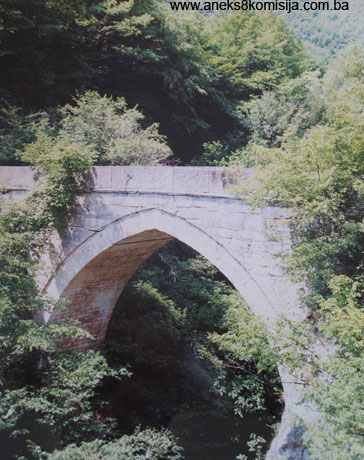
On the basis of known facts and the current condition on the ground, it may said with certainty that the bridge on the river Žepa River is one of the most beautiful and most elegant bridges of its kind in Bosnia and Herzegovina. While the bridge on the river Drina in Višegrad impresses by its grandeur and a certain stylistic and technical perfection, and the bridge in Mostar is impressive for its span and elegance, the bridge on the Žepa, although smaller in size, represents a monumental expression of both strength and beauty.
The steep, almost vertical banks of the river Žepa and the narrow gorge through which the river breaks towards its mouth, dictated the construction of a single-arch bridge, composed of a pointed arch with a span of 10.20 metres. The face walls of the bridge are composed by pointed arches both upstream and downstream, with a height of 6.50 metres, measured from the base of the barrel. The radius is 6.70 metres, and the excentricity of the centres of the curve from the vertical axis is 1.60 metres on both sides. The barrel is 75 centimetres deep. For the sake of comparison, and as evidence that the the Žepa bridge is stylistically identitical to the one in Višegrad, it may be noted that the span of this arch is closest to the first arch of the latter located next to the left bank; i.e. 10.70 metres. The barrel of the Višegrad bridge is 85 cm deep, while the excentricities of the centre of curve vary up to a maximum of 1.06 meters. The rise of the pointed arch of the bridge on the river Žepa is somewhat higher, which was dictated by the level of the road running high above the gorge.
The bridge is 21.60 metres long. The length from the symmetral of the barrel to the left bank is 12.40 metres, and to the right 9.20 metres. The overall width is 3.95 metres, of which the footway accounts for 3.40 metres and the parapet 20 cm on each side. The remainder consists of the string course below the parapet. The outer face of the spandrel walls is in the same plane as that of the parapet, while the voissoirs of the barrel are set back by 3-4 cm from the face of the spandrel walls. The barrel is 3.74 metres wide.
The highest point of the intrados of the bridge is about 12 metres above normal water level, while the roadway, including the depth of the barrel and of the upper level, is 1.55 metres higher. The parapet of the bridge, which had survived only in part prior to its reconstruction, was 90 cm high, so that the highest point of the bridge above normal water level was about 14.5 metres, which, proportionately to the span of the arch, «gave the impression of a bridge that aspires to the sky» (Ćelić, Mujezinović, p. 206.).
In absolute terms (above sea level), the abutments of the bridge were at an elevation of 273.8 metres, the roadway at 281.60 metres, and the river bed at 268.60 metres.
The barrel and frontal arches of the bridge were constructed of stone blocks of unequal size, apart from their height. The spandrel walls of the bridge were made of equally shaped limestone blocks measuring from 15 x 20 to 50 x 140 cm, or even more in some places. The blocks were not laid in perfectly horizontal courses, although the deviation from the horizontal was minimal. In terms of structure, these courses consist of a succession of horizontal blocks and vertical bonders, by means of which the architect achieved a unique play between the revetment of the spandrel walls and the core of the bridge, composed of a combination of quarry stone and limestone mortar. The joints between the stone blocks were regular and radial, and of minimum width. They were pointed with limestone mortar. On the surface, they were mostly calcified. On the inner side, the blocks were merely part-cut. The blocks were connected along the courses by wrought iron cramps set in lead. No such cramps were used on the vertical joints.
The spandrel walls terminate at roadway level in a simple moulded string course. The roadway itself rises slightly towards the centre, by about 4%. The entire roadway was laid with cobblestones.
No system of hydro-insulation was discovered in the bridge. The parapet was fixed to the wide horizontal slabs of the string course by iron spikes set in lead. The slabs forming the parapet were joined at the top by iron cramps set in lead.
The appearance of the bridge was much as it is now – spanning two almost vertical, rocky river banks. On the original site, the right bank was very steep, and the upper part of the left bank sloped at approx.46 degrees. Resting as it did directly on these steep rocks, at different heights, with a certain asymmetry of the spandrel walls in consequence of the different angle of the banks, the bridge seemed to have grown organically out of the rock.
3. Legal status to date
By Ruling of the Institute for the Protection of Cultural Monuments of Bosnia and Herzegovina dated 9 March 1966, the flooding of the bridge on the river Žepa was forbidden, until such time as the investor of the construction works paid the funds required to cover the cost of dismantling, transfer of material and reconstruction of the bridge on its new location.
The 1980 Regional Plan for Bosnia and Herzegovina listed the property as a Category I cultural and historical property.
Under the heading of the bridge on the river Žepa, the bridge is on the Provisional List of the Commission to Preserve National Monuments of Bosnia and Herzegovina under seriala no. 492.
4. Research and conservation and restoration works
Before the financial conditions had been met for the dismantling of the Žepa bridge, Rogatica Municipality, in cooperation with the BiH Institute for the Protection of Monuments, engaged an architectural firm (the Institute for Testing of Materials and Construction of the Civil Engineering Faculty in Sarajevo) to draw up projects to dismantle and reconstruct the bridge. Both projects were drawn up by Professor Ismet Tahirović. Once the conditions were met, a contract was signed with «Standard» Utilities and Civil Engineering Company from Rogatica to carry out the projects.
In 1966, after a series of analyses and examination of the terrain, a similar profile of the Žepa river basin was found some 500 metres from the town of Žepa, on a site called Spahin hrid (Spaho’s Rock). A detailed survey of the profile and its comparison with the original site led to the conclusion that the monument would fit almost perfectly into the new location, on the condition that the original upstream façade of the bridge became the downstream and vice versa, which was achieved by rotating the bridge by 180 degrees in relation to the river flow.
In the summer (June and July) of 1966, construction scaffolding was installed and the bridge was marked and dismantled, with the removal of the material at the elevation remaining above the highest water level of the reservoir. The removal of the stone fragments was carried out very carefully in order to avoid any damage to the stone blocks by the solid mass of the lime binder. The blocks were transported by horse and cart, and the entire process took about one month.
During 1967 reconstruction works were carried out by setting each element of the bridge exactly where it belonged. The binder used for the spandrel walls of the bridge was cement mortar. Other joints were treated in the original manner. The infill of the bridge was made of pieces of quarry stone bonded in cement mortar.
By the beginning of 1968, the bridge was back in use. On this new location the elevation of the piers of the bridge mainstay is 405.00 metres (previously 273.80 metres), the level of the intrados at the crown of the barrel is 411.50 metres, and the elevation of the roadway above the crown is 413.00 meters (previously 281.60 metres) above sea level. On this occasion a structural examination of the bridge was conducted, taking into account the existing dimensions and materials as well as the bridge’s own weight and the movable load of 1000 kg/m2. Although the lines of pressure arise from the cores of the intersections, the exclusion of tension forces means that the maximum stresses remain within acceptable limits. (Ćelić, Mujezinović, p. 208.).
5. Current Condition of the Site
Ever since the bridge has been restored to use, it has not been subject to any maintenance, apart from the removal of self-sown vegetation.
A crack about 10 metres long and 2 cm in height has appeared on the right side of the bridge about 90 cm below the level of the roadway and running along the entire length of the bridge and across the barrel. The cause of this is most probably the buckling of the right abutment of the bridge. It is unclear what is preventing the structure from collapsingn completely. A crack had appeared earlier on the parapet of the bridge.
III - CONCLUSION
Applying the Criteria for the adoption of a decision on proclaiming an item of property a national monument (Official Gazette of BiH nos. 33/02 and 15/03), the Commission has enacted the Decision cited above.
The Decision was based on the following criteria:
A. Time frame
B. Historical value
C. Artistic and Aesthetic Value
i.Quality of works,
ii.Quality of materials,
iii.Proportions,
iv.Composition,
v.Value of details,
vi.Value of construction.
D. Clarity (documentary, scientific, educational value)
ii. Evidence of historical change,
iii. Work of a significant artist or builder,
iv. Evidence of a particular type, style or regional manner
E. Symbolic value
iii Traditional value
v. Value for the identity of a group of people
F. Townscape/Landscape value
H. Rarity and representativity
I. Completeness (of monument, area, collection)
i.Physical integrity (compactness),
ii.Homogeneity,
iii.Completeness
The following documents form an integral part of this Decision:
o Copy of cadastral plan
o Copy of land register entry and proof of title;
o Photodocumentation;
o Drawings
o Site plan
Bibliography:
During the procedure to designate the bridge on the Žepa as a national monument of Bosnia and Herzegovina the following works were consulted:
1882 Matković, P., Dva italijanska putopisa po balkanskom poluotoku iz XVI stoljeća (Two 16th Century Italian Travelogues on the Balkan Peninsula), Starine X, p. 206
1866 ”Bosna” no. 14 of 15 and 27. 08. 1866, p. 1.
1886 Bosanska vila, yr. I. 1886, pp. 120-121
1887 Styh, E., Bauwesen in B. und H., Wien 1887
1889 Herman, K., Jnl of the National Museum, 1889, vol. I
1934 Gujić, Kasim, Najljepši turski mostovi u BiH (The Most Beautiful Turkish Bridges in BiH) , Gajret Calendar for 1934, Sarajevo,
1945 Bejtić, Alija, Sokolovićev most na Drini u Višegradu, (The Sokolović Bridge on the River Drina in Višegrad), Sarajevo, 1945
1953 Čelić, Džemal, Obnova Sokolovićeva mosta u Višegradu (Reconstruction of the Sokolović Bridge in Višegrad), Naše starine I, 1953
1957 Ayverdi, Ekrem, Hakki, Yugoslavia da Turk Abidelari ve vakiflari, Ankara 1957
1961 Gojković, Milan, Katanić, Nadežda, Građa za proučavanje starih mostova i akvadukata u Srbiji, Makedoniji, Crnoj Gori (Material for the study of old bridges and aqueducts in Serbia, Macedonia, Montenegro), Belgrade 1961
1968 Bašeskija, Mula Mustafa, Ljetopis (Chronicle), trans. M. Mujezinović, Sarajevo 1968
1969 Defterdarević Aziz, Pravni aspekti spasavanja starih mostova na Trebišnjici, Žepi i Drini (Legal aspects of rescuing old bridges on the Trebišnjica, Žepa and Drina), Naše starine no. 12, p. 61, 1969
1998 Čelić, Džemal, Mujezinović. Mehmed, Stari mostovi u BiH (Old bridges in BiH), Sarajevo Publishing, 1998
(1) Although the legends are in most cases the fruits of local people’s imagination and are not reliable indicators of the time when the monument was built, when combined with expert analysis of the complex (in this case the architecture of the bridge), persuasive conclusions can be drawn.
(2) In this legend it is stated that Sinan’s disciple was driven by the desire for fame, and a very good craftsman. He travelled down the river Drina and at the point where the Žepa joins the Drina, he built a stone arched bridge joining the two rocky banks of the river. Once Sinan saw this exquisite work, he was so enraged that he cut off both his disciple’s arms. (R. Michel, Farhten, p. 80). This legend resembles many legends relating the punishment suffered by master-builders. A similar punishment was suffered by the builder of the Taj Mahal, whose eyes were allegedly gouged out on the orders of Shah Jahan [translator’s note: the Bosnian version wrongly names the emperor who commissioned the Taj Mahal as “Shah Akbar”] so that he could never build anything similar to it.
(3) This legend is described in a narrative by the Nobel Prize winning novelist Ivo Andrić, Most na Žepi (The Bridge on the Žepa).
(4) Mujezinović and Čelić cite Michel’s hypothesis that a certain Meho, who allegedly built Kozija Ćuprija (Goat’s Bridge) in Sarajevo, is in fact Mehmed-Pasha Sokolović.
(5) It is a well-known fact that the aging Sinan was surrounded by a great number of young disciples who built over 300 buildings based on his designs.
(6) Ćelić and Mujezinović failed to give more detailed information on the origin and location where these documents had been kept.
(7) Thus Robert Michel cites the opinion that the bridge on the Žepa River dates from the same period as the Višegrad bridge and that its is the work of the same master builder. His impressions of the bridge are: «Several steps further down we stopped near a deep basin of the Žepa river and saw very close to us a beautiful stone arch that let to the other side of the gully. In this wilderness, such a noble edifice makes an even deeper impression. One could hardly make out, in the rocky gorge, where the structure begins, so harmoniously does the Gothic stone arch arise from the rocky steeps that one could easily imagine that the rocks themselves have bridged the gorge. »(R. Michel, p. 90)
(8) The basic components of stone bridges are:
- the foundations of the bridge – by which the structure is linked to the terrain. This component is of major importance for the stability of the structure;
- the piers of the bridge – the pier is the element via which the load of the structure is transferred to the foundations, and which is thus exposed to the constant action of the water;
- the arches/barrels of the bridge – the most important part of the structure, function and form of the bridge;
- the spandrel walls – elements defining the roadway of the bridge;
- the infill – material used to fill the cavities within the bridge
- relieving apertures – elements resulting from attempts to reduce the load and thus relieve the structure itself;
- the string courses – architectural details the moulding of which accentuates the division of the bridge into the load-bearing structure, the bearing structure of the barrel and arch, and the roadway with its parapet;
- the korkaluk or parapet – an architectural element designed essentially for safety;
- additional structural elements – wing walls, access ramps and the like;
- additional architectural elements – portals on the bridge, benches to rest on;
- guard towers.
|