Status of monument -> National monument
Pursuant to Article V para. 4 Annex 8 of the General Framework Agreement for Peace in Bosnia and Herzegovina and Article 39 para. 1 of the Rules of Procedure of the Commission to Preserve National Monuments, at a session held from 2 to 8 November 2004 the Commission adopted a
D E C I S I O N
I
The historic site of the old Srebrenik Fort in Srebrenik is hereby designated as a National Monument of Bosnia and Herzegovina (hereinafter: the National Monument).
The National Monument consists of the ramparts of the old fort, the ruins of a free-standing tower, and a bridge. The monument has not been surveyed archaeological and is a potential archaeological site (archaeological reserve) of movable archaeological material.
The National Monument is located on a site designated as cadastral plot no. 232/1 and 232/2 (new survey), corresponding to c.p. no. 161 (old survey), cadastral municipality Gornji Srebrenik, Land Register entry no. 170 in Srebrenik, Municipality Srebrenik, Federation of Bosnia and Herzegovina, Bosnia and Herzegovina.
The provisions relating to protection measures set forth by the Law on the Implementation of the Decisions of the Commission to Preserve National Monuments, established pursuant to Annex 8 of the General Framework Agreement for Peace in Bosnia and Herzegovina (Official Gazette of the Federation of BiH nos. 2/02, 27/02 and 6/04) shall apply to the National Monument.
II
The Government of the Federation of Bosnia and Herzegovina (hereinafter: the Government of the Federation) shall be responsible for ensuring and providing the legal, scientific, technical, administrative and financial measures necessary to protect, conserve, and display the National Monument.
The Government of Federation shall be responsible for ensuring funding for the drafting and implementation of the required technical documentation for the protection of the National Monument.
The Commission to Preserve National Monuments (hereinafter: the Commission) shall determine the technical requirements and secure the funds for preparing and setting up signboards with the basic data on the monument and the Decision to proclaim the property a National Monument.
III
To ensure the on-going protection of the National Monument, the following measures are hereby stipulated:
Protection Zone I consists of the area defined in Clause I, para. 3 of this Decision. In this zone the following protection measures shall apply:
- all works are prohibited other than research and conservation and restoration works, including those designed to display the monument, with the approval of the Federal Ministry responsible for regional planning and under the expert supervision of the heritage protection authority of the Federation of Bosnia and Herzegovina (hereinafter: the heritage protection authority),
- only expert archaeological surveys and excavations shall receive approval, which shall include the mandatory requirement to carry out conservation and restoration works,
- the site of the monument shall be open and accessible to the public and may be used for educational and cultural purposes
- the dumping of waste is prohibited.
To ensure the on-going protection of the National Monument, the following measures shall be carried out:
- clearing the ramparts of the fortress, the walls of the tower, the remaining facilities and the surroundings of wild plants presenting a danger to the structure of the monument,
- drawing up and implementing a programme for the presentation of the National Monument.
Protection Zone II shall consists of a protective strip from the boundaries of the National Monument to the base of the cliff and the access plateau.
In this zone the following protection measures shall apply:
- all construction and works that could have the effect of altering the site or the landscape are prohibited,
- infrastructure works are prohibited except with the approval of the federal ministry responsible for regional planning and the expert opinion of the heritage protection authority,
- the dumping of waste is prohibited.
IV
Since the site is an archaeological reserve, the removal of the archaeological material referred to in Clause 1 para. 2 of this Decision (hereinafter: the movable heritage) from Bosnia and Herzegovina is prohibited.
By way of exception to the provisions of paragraph 1 of this Clause, the temporary removal from Bosnia and Herzegovina of the movable heritage for the purposes of display or conservation shall be permitted if it is established that conservation works cannot be carried out in Bosnia and Herzegovina.
Permission for temporary removal under the conditions stipulated in the preceding paragraph shall be issued by the Commission to Preserve National Monuments, if it is determined beyond doubt that it will not jeopardize the movable heritage in any way.
In granting permission for the temporary removal of the movable heritage from Bosnia and Herzegovina, the Commission shall stipulate all the conditions under which the removal may take place, the date by which the items shall be returned to Bosnia and Herzegovina, and the responsibility of individual authorities and institutions for ensuring that these conditions are met, and shall notify the Government of the Federation of Bosnia and Herzegovina, the relevant security service, the customs authority of Bosnia and Herzegovina, and the general public accordingly.
V
All executive and area development planning acts not in accordance with the provisions of this Decision are hereby revoked.
VI
Everyone, and in particular the competent authorities of the Federation of Bosnia and Herzegovina, the Canton, and urban and municipal authorities, shall refrain from any action that might damage the National Monument or jeopardize the preservation and rehabilitation thereof.
VII
The Government of the Federation, the Federal Ministry responsible for regional planning, the heritage protection authority, and the Municipal Authorities in charge of urban planning and land registry affairs, shall be notified of this Decision in order to carry out the measures stipulated in Articles II to VI of this Decision, and the Authorized Municipal Court shall be notified for the purposes of registration in the Land Register.
VIII
The elucidation and accompanying documentation form an integral part of this Decision, which may be viewed by interested parties on the premises or by accessing the website of the Commission (http://www.aneks8komisija.com.ba)
IX
On the date of adoption of this Decision, the National Monument shall be deleted from the Provisional List of National Monuments of Bosnia and Herzegovina (Official Gazette of BiH no. 33/02, Official Gazette of Republika Srpska no. 79/02, Official Gazette of the Federation of BiH no. 59/02, and Official Gazette of Brčko District BiH no. 4/03), where it featured under serial no.576.
X
Pursuant to Art. V para 4 Annex 8 of the General Framework Agreement for Peace in Bosnia and Herzegovina, decisions of the Commission are final.
XI
This Decision shall enter into force on the date of its adoption and shall be published in the Official Gazette of BiH.
This Decision has been adopted by the following members of the Commission: Zeynep Ahunbay, Amra Hadžimuhamedović, Dubravko Lovrenović, Ljiljana Ševo and Tina Wik.
No: 05.2-2-246/04-2
2 November 2004
Sarajevo
Chair of the Commission
Amra Hadžimuhamedović
E l u c i d a t i o n
I – INTRODUCTION
Pursuant to Article 2, paragraph 1 of the Law on the Implementation of the Decisions of the Commission to Preserve National Monuments, established pursuant to Annex 8 of the General Framework Agreement for Peace in Bosnia and Herzegovina, a “National Monument” is an item of public property proclaimed by the Commission to Preserve National Monuments to be a National Monument pursuant to Articles V and VI of Annex 8 of the General Framework Agreement for Peace in Bosnia and Herzegovina and property entered on the Provisional List of National Monuments of Bosnia and Herzegovina (Official Gazette of BiH no. 33/02) until the Commission reaches a final decision on its status, as to which there is no time limit and regardless of whether a petition for the property in question has been submitted or not.
The Commission to Preserve National Monuments issued a Decision to add the Srebrenik-Fortress to the Provisional List of National Monuments of Bosnia and Herzegovina, numbered as 576.
Pursuant to the provisions of the law, the Commission proceeded to carry out the procedure for reaching a final decision to designate the Property as a National Monument, pursuant to Article V of Annex 8 and Article 35 of the Rules of Procedure of the Commission to Preserve National Monuments.
II – PROCEDURE PRIOR TO DECISION
In the procedure preceding the adoption of a final decision to proclaim the property a national monument, the following documentation was inspected:
- Documentation on the location and current owner and user of the property (copy of cadastral plan and copy of land register entry)
- Data on the current condition and use of the property, including a description and photographs, data of war damage, data on restoration or other works on the property, etc.
- Historical, architectural and other documentary material on the property.
The findings based on the review of the above documentation and the condition of the site are as follows:
1. Details of the property
Location
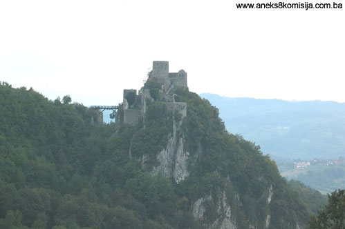
The old Srebrenik fort is situated on the northeastern slopes of Mt. Majevica, in the village of Gornji Srebrenik, some 5 kilometers from the small town of Srebrenik. The old fort was built on a high and steep, almost inaccessible rock above the river Tinja. A deep cutting was dug out below the most easily accessible part of the fort, so that it can only be reached via the bridge. It is five kilometres from the present-day Tuzla-Županja or Tuzla-Lončari-Brčko road.
Historical information
At certain times in the past the Srebrenik fort was of major strategic importance as a defence point for a wide area. It is situated between the Pannonia plains and the mountainous region of Bosnia. In the mediaeval period it protected the area south of the Sava from the aspirations of the Hungarian crown of St Stephen. During the Ottoman period, in the late 15th and early 16th centuries, when political and military aspirations were at times in opposing directions, first by the Hungarians and the Ottomans and then, in the 17th and 18th centuries, by the Austrians, it regained its importance.
The old Srebrenik fort was close to the eastern border of the mediaeval župa (county) of Usora, the history of which can be traced in the context of the mediaeval Bosnian state from the 13th to the 15th century (Anđelić, 1977, 142-172). It lay on the military route along the valley of the river Bosna, important in military, i.e. strategic, terms, but lacking the possibility of any major civilian settlements taking shape (Kovačević-Kojić, 1978., 82-84). The oldest reference to this fort dates from 1333, when a dispute arose between the Bosnian ban (governor) Stjepan II Kotromanić and Serbia’s King Dušan over the ownership of Ston. Dubrovnik sensed that this was an opportune moment for it to bring Ston and other coastal territories as far as Prevlaka under its own rule. They resorted to diplomacy to reconcile the two rulers, with Ston the price for this diplomatic success. The charter by which he waived his rights to Ston was issued by the Bosnian ban Stjepan II on 15 February 1333, below the Srebrenik fort (Jalimam, 2004, 24; Nilević, 2003, 39).
Srebrenik first came under Hungarian rule in 1393, during a campaign by King Sigismund (1387-1437). From then on, Hungarian military campaigns against Bosnia became more frequent. The Hungarians occupied Srebrenik on another three occasions, in 1405, 1408 and 1410.
In 1408, in order to weaken Bosnia, Hungary’s King Sigismund nominally bestowed the Srebrenik fort to the Serbian despot Stefan Stefan Lazaravić (Handžić, 1975, 23; Jalimam, 2004, 26). A Hungarian garrison remained in the fort where, according to historical documents, it was recorded as still in occupation in 1430 (Handžić, 1975, 22-23; Basler, 1957, 120, Jalimam, 2004, 26). It was then that, at the invitation of Prince Matej, “a loyal servant of the Hungarian King Sigismund of Luxbembourg,” Dubrovnik craftsmen carried out certain building works on the Srebrenik fort. It seems that in 1433 Bosnia’s King Tomaš succeeded in regaining control of Srebrenik. In 1452 the Usora district and the Srebrenik fort belonged to the Serbian despot Đurađ Branković, who restored it that same year to the Hungarian governor Janko Siginjanin (Handžić, 1975, 23,28; Jalimam, 2004, 31). At that time Srebrenik was of great importance to the Hungarians, Bosnians and Ottomans, and in consequence there were frequent battles over it.
Since the territory south of the Sava as far as the mountains of Bosnia was a very insecure region between the frontiers of Bosnia and Hungary, a number of fortified towns came into being in the region between the rivers Sava, Drina and Bosna. Two parallel lines of fortifications can be discerned: to the north, with the forts of Dobor, Gradačac and Koraj, and to the south, consisting of the forts of Doboj, Soko, Srebrenik and Teočak. In the summer of 1426, the Ottomans carried out two incursions into the county of Usora and reached the outskirts of Srebrenik. It was finally conquered during the Ottoman invasion of Bosnia in 1426, when Dubrovnik announced, in a letter dated 13 October that year, that the entire county of Usora had been occupied. With the occupation of the majority of Bosnian territory in 1463, Srebrenik’s strategic importance grew. The same frontier forts now became important strategic points between the zones of interest of two forces: Hungary and the Ottoman Empire. The Ottomans left small garrisons in the forts, and finally the military were forced by supply shortcomings to withdraw from the territory. In the autumn of 1464, the Hungarian army of King Matthias Corvinus, commanded by Ivan Zapolja, attacked north-eastern Bosnia with the intention of forcing out the small Ottoman garrisons remaining in the conquered fortresses and establishing a defence line from Belgrade to Jajce. His chief objective was the conquest of Zvornik, which he did not achieve with that army. However, he did take Srebrenik, followed by a number of other fortresses. Northern Bosnia (Donji Krajevi and Usora) came under Hungarian rule, and the Jajce and Srebrenik banates were formed from these territories. The latter took in Usora, Soli and Spreča, with their local towns; the banate’s headquarters was in the Srebrenik fort (Handžić, 1975, 35; Šabanović, 1982, 42). However, battles were waged in north-eastern Bosnia the whole time between the Hungarians and the Ottomans. They first entered into a truce from 1503 to 1510, and again from 1520 to 1523. However, during the 1503-1510 truce, Srebrenik and its banate, along with other major forts, remained a Hungarian holding.
After Sultan Selim I came to the throne in 1512, the operations of the Ottoman army in Bosnia were stepped up. It is not known exactly when Srebrenik was taken. According to Handžić, the only thing known for sure is that the Ottomans finally conquered this district between 1510 and 1519, or in other words between the two truces. When Srebrenik fell, the Srebrenik banate was divided into a number of nahijas (corresponding to the territories of the late mediaeval župas or counties), and merged with the Zvornik sandžak and kadiluk. With the occupation of these territories, which meant that the Hungarian defence line had been breached, a new, intensive stage of Ottoman conquests to the north and west (territory in Croatia) and the east (towards Šapac, i.e Mačva, and Belgrade) (Handžić, 1975, 27-48; Šabanovićm 1982, 53-56). The territory between the Bosnian mountains and the Sava remained an insecure frontier region until the end of the third decade of the 16th century. As a result, many of the towns and forts in this region are not referred to in the census lists (defters). The garrisons serving in these forts were ulufedžija (paid troops, unconnected to timars [properties that provided some soldiers with their income]). Since Srebrenik was part of the southern frontier line, it already had a permanent garrison of 48 mustahfiz (soldiers granted timars as their source of income), but according to the 1548 census, the garrison had been reduced to a mere 21 mustahfiz, meaning that the frontier had shifted northwards across the Sava to Hungarian territory in Slavonia. These somewhat depopulated areas began to be settled at this time (Handžić, 1975, 72, 134). Ottoman defters also record a town below the fort. This was a small settlement on the outskirts with 10 to 20 houses, which differed from a village in having a market square. According to the 1533 census, the Srebrenik nahija had 73 houses (households) and 31 bachelors, but by 1458 there were already 486 houses and 11 bachelors (Handžić, 1975, 135-136).
After the final conquest of Srebrenik and the beginning of Ottoman rule, an imperial (state) mosque was built. This mosque was intended primarily for the garrison in the fort, but also for the residents of the town (Handžić, 1975, 143-144).
There is no major information concerning Srebrenik between the battle of Mohács (1526) and the Treaty of Karlowitz in 1717. Once the borders of the Ottoman Empire had shifted to the north and northeast, the fort lost its importance. It is not known whether it was abandoned, or whether the Ottomans left a small garrison there (Kreševljaković, 1953, 40).
Between 1710 and 1730, the Gradačac captaincy was established, which included Srebrenik. The fort had no dizdar (fortress commander); instead, the garrison was commanded by the ćehaja (deputy) of the Gradačac kapetan (captain).
It is not known to whom Srebrenik was assigned under the terms of the 1718 Treaty of Passarowitz. The Austrian border was shifted by an hour’s ride, or in places half an hour’s, south of the river Sava, leaving the area of northern Bosnia strategically unsecured. An Austrian map dating from 1718 shows the Soko fortress near Gračanica, and Srebrenik is marked as a village, which suggests that the fort in Srebrenik was in ruins. During the 18th century, followingn the 1739 Treaty of Belgrade, the Srebrenik fort again became strategically important. An Austrian spy of this time refers to Srebrenik as an old castle, without providing a more detailed description (Bodenstein, 1908, 98). The assumption is that the ruins of the fort were demolished around this time, except for the north tower III, which had been turned into a mosque after Srebrenik was taken by the Ottomans in the 16th century, and thus survived. A new fort was built on the foundations of the old one, which was the only possible course of action on such a site. The first reference to repairs to Srebrenik dates from 1756, followed by another in 1777, when the fort underwent minor repairs (of what kind exactly is not known).
The only other known information is that in 1804 the garrison consisted of some 20 young men, and that in 1833 there were 7 cannon in the fort (Kreševljaković, 1952, 168).
According to a record dating from 1838, the fort was to be repaired.
The army abandoned it after 1835. The mosque was maintained for several more decades (Basler, 1957, 121-122; Kreševljaković, 1953, 40).
2. Description of the property
The layout of the defence facilities in the old Srebrenik fort was dictated by the nature of the site. The fort was built on a cliff rising above the surrounding terrain to a height of some 50 to 70 metres. The upper plateau of the cliff is uneven and fissured. The difference in altitude between the lowest point, where tower III stands, and the highest is about 13 metres. As a result, the entire fort is compressed into an area of about 60 m (north/south) by 30 m (east/west).
To the south of the gate house outside the fosse, about 17 metres from the entrance to the fort, are the ruins of a free-standing square tower the sides of which are 7 m in length.
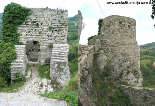
Tower no. I. The entrance to the fort is through the gate house on the south-eastern slope. There is a large artificial fosse before this slope, making access to the fort possible only via the bridge. This tower measures 6.5 x 5.6 m. The tower has two storeys divided by an arched vault. The large arched gates, narrower on the outside than on the inside, are on the outer (east) side. Holes for hinges can be seen on the door jambs. The floor of the tower is paved with stone slabs. It has no roof. Facing the tower from the fort, the remains of steep, narrow stone steps can be seen to the right, leading to the first floor. The door jambs and arch of the main entrance to the fort on the east (outer) façade of the tower are of cut stone. A crescent moon is carved into the base of the north arm of the arch. On the first floor, above the arch, are small, low-set windows, with three narrow loopholes above them. A plaque is set into the wall between the windows, where there was probably a chronogram, but inn 1954 it had already been destroyed by gunfire. The small loophole slantwise above the left-hand window, set between two cracks, was also intended for defence. The tower has survived almost up to the roof, to a height of 7.5 metres. Outside the west wall of the tower was an artificial plateau designed to facilitate access to the fort.
To the south, beside the gate house, is a small partitioned-off, arch-vaulted area with a trapezoid ground plan. Tradition has it that this was the kitchen.
A rampart runs down from the gate house northwards over a length of 15 m, turning sharply towards tower II. At the base of this bend is a side entrance, which is difficult of access. Subsequently, in the 1950s, a retaining wall was built on the outer side of the rampart below the gate, and rustic steps leading to the gate house. The steps are made of rough-cut slabs of phyllite set in a concealed concrete mass. These were modelled on the old steps leading from the mosque (tower III) to the keep (tower IV) (Basler, 1957, 124).
Tower II. The narrow retaining wall built in 1954 leads from the gate house to tower II. The retaining wall was made of phyllite slabs bonded with concrete, and was made to resemble outwardly the old structures (Basler, 1967, 124).
Tower II is of elongated horseshoe shape, with interior dimensions of approx. 5 m in length and 3.5 m in width. It survives to a height of 4.5 m. It was separated by a lightweight timber structure into two storeys. The only openings were loopholes.
The North Bailey was built between towers II and III. It is approx. 17 metres long and 9 metres wide. The ramparts, which are 2.10 metres thick, have 7 apertures for cannon, and it seems that this bailey was used as a cannon emplacement. The defence wall of this bailey was built in the 18th century. The structure of the walls reveals no subsequent additions or extensions, and in structure it is identical to buildings of the purely Ottoman period. The walls survive to a height of approx. 2.20 m.
The northeast corner of Tower III abuts onto the west wall of the bailey. This tower is rectangular in ground plan, measuring 6.70 x 7.50 m. It contains a cistern. After the conquest of Srebrenik, the Ottomans built a mosque here, which was still in use in the late 19th century. By the 1950s, it was the least well preserved building in the fort. It is completely different in the way it was built from the other buildings in the fort. The floor contains a circular opening of the size of a small well. The foundation walls go off in various directions, making the tower look as though it was built on an older building that had previously been demolished. Light grey limestone bonded with lime mortar was used as building material. The method of construction suggests that this is a mediaeval building. The core of the wall is a mixture of slaked lime (lime mortar) and hardcore, and the facing of stone laid in courses (Basler, 1967, 125). The remains of the mosque have been removed, and there is a well at the base of the tower.
Upper part of the fort
The stairs leading from tower III lead to the complex of the upper fort, consisting of a keep, cistern, and residential building. To the south is a small bailey adjoining the residential building; it is not certain whether this bailey was in existence in the mediaeval period.
The Keep (Tower IV) stands on the highest point of the fort, facing the gate house, and defending the access area outside the fort (the bridge and plateau). The ground plan of the keep is an irregular circle. The interior measures 4.8 x 5.2 m. The foundation walls are up to 2.85 thick, and the attic walls are 1.3 m thick. In addition to the ground floor, there were two more storeys separated by timber joists. The upper storeys were reached via wooden steps. The roof was set directly on the wall at a height of 6.7 m. Judging from the ruins, the walls were not plastered. The tower contains no abdestluk (facilities for ritual ablutions before prayer), fireplace or suchlike, meaning that was not used for permanent residence (Basler, 1957, 126).
The Cistern is located between the entrance to the upper fort and the keep (tower IV), onto which it abuts. The cistern itself is barrel-vaulted. It is 2.7 m in height and width, and 5.2 m in length, with a capacity of 2m3. It was formerly covered with a coat of red hydraulic lime, most of which has fallen away (Basler, 1957, 127).
Residential Building together with the keep, this is the central object of the fort. During the mediaeval period, this was probably the most representative part of the fort. Rebuilding in the 18th century resulted in the disappearance of the mediaeval structure. It was probably used as accommodation for the garrison during the Ottoman period. The building has a basement and ground floor. Its elongated shape is adapted to the lie of the land. It lies east-west, with the outer east wall 24 m and the outer west wall 19.5 m long; it is 6.2 m wide. The east wall, facing the keep, has two entrances: the main one in the middle of the wall, 1.6 m in width, and a side entrance by the entrance to the upper fort, which is 1.3 m in width. The thickness of the east, protected wall is 0.8 m, whereas the other three outer walls are 1.15 m thick. There are now no partition walls in the interior, but formerly a corridor ran along the entire length of the east wall. There were two privies in semicircular niches at the south end of the corridor, fitted with the appropriate drainage pipes. There are two windows at the north end of the corridor. The corridor led into four rooms, each of which contained an abdestluk in a small wall niche, a stove (in the centre) and a window. The room by the south wall had another two dolafs (wall cupboards) in the south wall, and the room byb the north wall had another window in that wall. All the rooms along the west wall were separated by partition walls between the window of one and the abdestluk of the adjoining room. The framework of the partition walls was composed of beams, of which the sockets have survived. The floor was wooden (Basler, 1957, 127). The roof gables of the south and north walls have survived. It is thus known that the roof was clad with stone slabs, of the same type of stone as the entire complex o the old fort. The roof was low-set. The water drained away from the abdestluks through stone gutters projecting out from the wall by 20 cm. The hearths of the stoves were insulated from the walls by slabs of tufa to avoid damage to the stone walls, which contained a high proportion of lime.
The basement, with a small antechamber and a longish hall, ran along the building. The basement is barrel-vaulted.
Another zigzag rampart with a row of loopholes and a large arched opening ran from the south-east corner of the building. This rampart protected the south wall of the building. The area constitutes the south bailey.
The ramparts of the fort and the outer parts of the walls of all the towers and baileys which, together with the ramparts, constituted the curtain wall of the fort, are about 1.5 m thick; all the other walls within the ramparts are less thick. The entire fort was built at one time. Because there are no tie beams, Basler is of the opinion that the reconstruction of the other buildings and of almost the entire Srebrenik fort was carried out in the 18th century, when the method of building with tie beams had already been abandoned (Basler, 1957, 120-121).
3. Legal status to date
In the procedure prior to adoption of the final decision to designate, documents concerning the protection of the property were inspected, and the following was ascertained:
The architectural ensemble of the old Srebrenik Fort in Gornji Srebrenik was placed under state protection by Ruling no. 277/51 of the National Institute for the Protection of Cultural Monuments and Natural Rarities of NRBiH. By Ruling no. 02-781-3 of 18 April 1962 it was entered on the register of immovable cultural monuments.
The property is on the Provisional List of National Monuments of Bosnia and Herzegovina under the heading Srebrenik – Fort, serial no. 576.
The Regional Plan Stage B – Valorization, of 1980-2002, lists the mediaeval fort of Srebrenik as a category I property.
On 12 May 1977 the Municipal Assembly of Srebrenik adopted a decision to form an “Open City of Art” in Srebrenik.
On 18 August 1977 the Municipal Assembly of Srebrenik adopted a decision to designate the site of the Old Fort as a site of special use.
4. Research and conservation and restoration works
In 1954, preparatory works were undertaken for conservation. As part of these works, retaining walls were built between towers I and II and in front of the side gate in the north rampart. In addition, to facilitate communication, stairs were built from the side entrance to tower I.
In 1955, conservation works were carried out the residential building in the old Srebrenik Fort.
In 1975-1978, conservation works were completed on all the buildings in the old Fort, and a new bridge was built as access to the fort. In 2000 this bridge was in ruins.
In 2003-2004, the present bridge was built providing access to the old Srebrenik Fort.
All of these works were carried out by experts from the Republic Institute for the Protection of Cultural and Natural Heritage of Bosnia and Herzegovina in Sarajevo.
5. Current condition of the property
Since Srebrenik was subjected to thorough conservation in 1975 to 1978, and a new, sturdy bridge was built in 2003 to provide access to the fort, there is no serious damage or need for major interventions.
The north and south baileys and the keep are overgrown with vegetation, which needs to be cleared, since it is damaging the walls. Tufts of grass have taken root in many places, particularly on the inside of the walls of the residential building.
Minor interventions are required in some places where stones are missing from the revetments and facings of the walls: inside the residential building, on the masonry by the steps leading from the keep to the entrance to the upper fort. The arch above the entrance to the fort in tower I needs attention.
Many surfaces have graffiti scribbled on them, spoiling the patina of the fort. The basement of the residential building contains piles of garbag. All these interventions constitute routine maintenance works.
The free-standing tower has been half demolished.
The site has not been archaeologically surveyed.
III – CONCLUSION
Applying the Criteria for the adoption of a decision on proclaiming an item of property a national monument (Official Gazette of BiH nos. 33/02 and 15/03), the Commission has enacted the Decision cited above.
The Decision was based on the following criteria:
A. Time frame
B. Historical value
D. Clarity (documentary, scientific and educational value)
D.i. material evidence of a lesser known historical era
D.ii. evidence of historical change
E. Symbolic value
E.iii. traditional value
E.v. significance for the identity of a group of people
F. Townscape/ Landscape value
F.ii. meaning in the townscape
F.iii. the building or group of buildings is part of a group or site
G. Authenticity
G.v. location and setting
I. Completeness
I.iii. completeness
The following documents form an integral part of this Decision:
- Copy of cadastral plan
- Photodocumentation;
- Drawings
Bibliography
During the procedure to designate the monument as a national monument of Bosnia and Herzegovina the following works were consulted:
1904. Truhelka, Ćiro, Naši gradovi (Our Towns). Sarajevo, Naklada Knjižare J. Studnička and others. 1904.
1908. Bodenstein, Gustav, Povijest naselja u Posavini 1718-1739. (History of Settlements in Posavina 1718-1739), Jnl of the National Museum in Sarajevo XX, Sarajevo, 1908, 95-112
1952. Kreševljaković, Hamdija, Prilozi povijesti bosanskih gradova pod turskom upravom. Prilozi za orijentalnu filologiju i istoriju jugoslovenskih naroda pod turskom vladavinom (Contributions to the History of Bosnian Towns under Turkish Administration, Contributions for Oriental Philology and the History of the South Slavs under Turkish Governance), II/1951, Institute for Oriental Studies in Sarajevo, Sarajevo, 1952,119-184.
1953. Kreševljaković, Hamdija, Stari bosanski gradovi. (Old Bosnian Forts), Naše starine I, Sarajevo, 1953, 7-45.
1957. Basler, Đuro, Stari grad Srebrnik i problematika njegove konzervacije (The Old Srebrenik Fort and Issues of Its Conservation). Naše starine IV, Sarajevo, 1957, 119-130
1957. Vego, Marko, Naselja srednjovjekovne bosanske države (Settlements of the mediaeval Bosnian state), Sarajevo, 1957.
1978. Kovačević-Kojić, Desanka, Gradska naselja srednjovjekovne bosanske države. (Urban Settlements of the Mediaeval Bosnian State), Sarajevo, 1978.
1982. Anđelić, Pavao, O usorskim vojvodama i političkom statusu Usore u srednjem vijeku (On the Usora counts and the political status of Usora in the mediaeval period), In: Studije o teritorijalno političkoj organizaciji srednjovjekovne Bosne (Studies on the territorial and political organization of mediaeval Bosnia), Sarajevo, 1982, 142-172
1982. Šabanović, Hazim, Bosanski pašaluk (The Bosnian pashaluk), Sarajevo, 1982.
2003. Nilević, Boris, Srebrenik u srednjem vijeku na historijskoj sceni (Srebrenik in the mediaeval period on the historical scene), Biljeg Srebrnika no. 1, Srebrnik, August 2003, 39-52.
2004. Jalimam, Salih, Srednjovjekovna historija Srebrenika (Mediaeval history of Srebrenik), Biljeg Srebrnika no. 2, Srebrnik, 2004,21-40.
|