Status of monument -> National monument
Pursuant to Article V para 4 Annex 8 of the General Framework Agreement for Peace in Bosnia and Herzegovina and Article 39 para 1 of the Rules of Procedure of the Commission to Preserve National Monuments, at a session held from 2 to 8 November 2004 the Commission adopted a
D E C I S I O N
I
The archaeological site of the remains of Tašlihan in Sarajevo is hereby designated as a National Monument of Bosnia and Herzegovina (hereinafter: the National Monument).
The National Monument consists of the archaeological site of the remains of the Tašlihan walls and movable artifacts found at the archaeological area, and housed in the Sarajevo Cantonal Institute for Protection of the Cultural, Historical and Natural Heritage.
The National Monument is located on cadastral plots no. 92, Land Register entry no. IX/72, c.p.no. 93, Land Register entry no. IX/71, c.p.no. 95, Land Register entry no. IX/65, c.p.no. 96, Land Register entry no. 66, c.p. no 97, Land Register entry no. IX/67, c.p. no 98, Land Register entry no. IX/69, c.p. no 99, Land Register entry no. IX/103, c.p. no 102, Land Register entry no. IX/68, c.p. no 103, Land Register entry no. IX/70, c.p. no 105, Land Register entry no. IX/100, c.p. no 106, Land Register entry no. IX/107, c.p. no 109, Land Register entry no. IX/101, c.p. no 110, Land Register entry no. IX/102, c.p. no 113, Land Register entry no. IX/109, k. o. Sarajevo, mahala IX (92, 93, 95, 96, 97, 98, 99, 102, 103, 105, 106, 109, 110, 113 (old survey), cadastral municipality Sarajevo, Federation of Bosnia and Herzegovina, Bosnia and Herzegovina.
The provisions relating to the protection measures set forth by the Law on the Implementation of the Decisions of the Commission to Preserve National Monuments, established pursuant to Annex 8 of the General Framework Agreement for Peace in Bosnia and Herzegovina (Official Gazette of the Federation of BiH nos. 2/02, 27/02 and 6/04) shall apply to the National Monument.
II
The Government of the Federation of Bosnia and Herzegovina (hereinafter: the Government of the Federation) shall be responsible for ensuring and providing the legal, scientific, technical, administrative and financial measures necessary to protect, conserve and display the National Monument.
The Commission to Preserve National Monuments (hereinafter: the Commission) shall determine the technical requirements and secure the funds for preparing and setting up signboards with the basic data on the monument and the Decision to proclaim the property a National Monument.
III
To ensure the on-going protection of the National Monument, yhe following measures are hereby stipulated:
The protection zone consists of the area defined in Clause I para 3 of this Decision. The protection regime pertains to the area both above and below ground. In this zone the following measures shall apply:
- all works are prohibited other than archaeological and conservation and restoration works including works designed to display the National Monument, with the approval of the ministry responsible for area planning in the Federation of Bosnia and Herzegovina (hereinafter: the relevant ministry) and under the expert supervision of the heritage protection authority of the Federation of Bosnia and Herzegovina
- the site of the National Monument site shall be open and accessible to the public and may be used for educational and cultural purposes.
- the dumping of waste is prohibited.
The Government of the Federation shall be responsible in particular for the following:
- drawing up a project for the protection of the site from further deterioration
- drawing up a project for the presentation of finds and the ruins
- clearing the area of overgrowth and making good the site
- continuing archaeological investigations by extending the area so far investigated to the west by up to 15 m, as necessary, and opening a trench in the northernmost section. A report on the investigations conducted and any finds shall be presented to the Commission to enable it, if necessary, to amend this Decision, in line with the Rules of Procedure of the Commission.
IV
The removal of the movable heritage referred to in Clause 1 para. 2 of this Decision (hereinafter: the movable heritage) from Bosnia and Herzegovina is prohibited.
By way of exception to the provisions of paragraph 1 of this Clause, the temporary removal from Bosnia and Herzegovina of the movable heritage for the purposes of display or conservation shall be permitted if it is established that conservation works cannot be carried out in Bosnia and Herzegovina.
Permission for temporary removal under the conditions stipulated in the preceding paragraph shall be issued by the Commission to Preserve National Monuments, if it is determined beyond doubt that it will not jeopardize the movable heritage in any way.
In granting permission for the temporary removal of the movable heritage from Bosnia and Herzegovina, the Commission shall stipulate all the conditions under which the removal may take place, the date by which the items shall be returned to the country, and the responsibility of individual authorities and institutions for ensuring that these conditions are met, and shall notify the Government of the Federation of Bosnia and Herzegovina, the relevant security service, the customs authority of Bosnia and Herzegovina, and the general public accordingly.
V
All executive and area development planning acts not in accordance with the provisions of this Decision are hereby revoked.
VI
Everyone, and in particular the competent authorities of the Federation of Bosnia and Herzegovina, cantonal, urban and municipal authorities, shall refrain from any action that might damage the National Monument or jeopardise the protection thereof.
VII
The Government of the Federation, the Federal ministry responsible for regional planning, the Federal ministry responsible for culture, the heritage protection authority of the Federation of Bosnia and Herzegovina, and the municipal authority in charge of urban planning and land registry affairs, shall be notified of this Decision in order to carry out the measures stipulated in Articles II to VI of this Decision, and the authorised Municipal Court shall be notified for the purpose of registration in the Land Register.
VIII
The elucidation and accompanying documentation form an integral part of this Decision, which may be viewed by interested parties on the premises or by accessing the website of the Commission (http://www.aneks8komisija.com.ba)
IX
On the date of adoption of this Decision, the National Monument shall be deleted from the Provisional List of National Monuments of Bosnia and Herzegovina (Official Gazette of BiH no. 33/02, Official Gazette of Republika Srpska no. 79/02, Official Gazette of the Federation of BiH no. 59/02, and Official Gazette of Brčko District BiH no. 4/03), where it featured under serial no. 568.
X
Pursuant to Art. V, para 4 Annex 8 of the General Framework Agreement for Peace in Bosnia and Herzegovina, decisions of the Commission are final.
XI
This Decision shall enter into force on the date of its adoption and shall be published in the Official Gazette of BiH.
This Decision has been adopted by the following members of the Commission: Zeynep Ahunay, Amra Hadžimuhamedović, Dubravko Lovrenović, Ljiljana Ševo and Tina Wik.
No: 05.1-2-241/04-8
3 November 2004
Sarajevo
Chair of the Commission
Amra Hadžimuhamedović
E l u c i d a t i o n
I – INTRODUCTION
Pursuant to Article 2, para 1 of the Law on the Implementation of the Decisions of the Commission to Preserve National Monuments, established pursuant to Annex 8 of the General Framework Agreement for Peace in Bosnia and Herzegovina, a "National Monument" is an item of property proclaimed by the Commission to Preserve National Monuments (hereinafter: the Commission) to be a National Monument pursuant to Articles V and VI of Annex 8 of the General Framework Agreement for Peace in Bosnia and Herzegovina (hereinafter: Annex 8) and property entered on the Provisional List of National Monuments of Bosnia and Herzegovina (Official Gazette of BiH no. 33/02) until the Commission reaches a final decision on its status, as to which there is no time limit and regardless of whether a petition for the property in question has been submitted or not.
The Commission to Preserve National Monuments issued a Decision to add the archaeological site of Tašlihan to the Provisional List of National Monuments of Bosnia and Herzegovina, numbered as 534.
Pursuant to the provisions of the law, the Commission proceeded to carry out the procedure for reaching a final decision to designate the Property as a National Monument, pursuant to Article V, para 4 of the Annex 8 and Article 35 of the Rules of Procedure of the Commission to Preserve National Monuments.
II – PROCEDURE PRIOR TO DECISION
In the procedure preceding the adoption of a final decision to proclaim the property a national monument, the following documentation was inspected:
- Documentation on the location and current owner and user of the property (copy of cadastral plan and copy of land registry entry),
- Data on the current condition and use of the property, including description and photographs, data of war damage, data on restoration or other works on the property, etc.,
- Historical, architectural and other documentary material on the property.
The findings based on the review of the above documentation and the condition of the site are as follows:
1. Details of the property
Location
The remains of Tašlihan are located on a site which is now the garden of the Hotel Europe, next to the western wall of the Gazi Husrev-bey bezistan (covered market).
Historical information
Many written sources and monuments of material culture attest to the fact that the 16th century in Sarajevo was a time of general prosperity and urban development. Vakufs (endowments) and their benefactors and legators, representatives of the feudal class and of crafts and trade guilds who used their financial resources to develop the town, played an important part in this. They built mosques, bezistans, hans (inns), caravanserais (way-stations for caravans), bridges, schools and other buildings. At the end of the 15th century the town had three mahalas (residential areas), a jama’at (religious congregation) of Christians and a community of people from Dubrovnik, and at the end of the 16th century it had 91 Moslem mahalas, two Christian congregations and a Jewish congregation in addition. (B. Zlatar, 1997, 54)
The 16th century represents a golden age in the history of Sarajevo, first and foremost because of Gazi Husrev-bey, without doubt the pre-eminent Bosnian governor. In 1530 Gazi Husrev-bey built a mosque, with the Kuršumlija medresa and library opposite. Close to the medresa he built a haniqah. A hammam (Turkish bath) was also built with funds provided by this great benefactor, as well as a bezistan and, next to it, Tašlihan. This is nowadays the only surviving hammam of the seven that used to exist in Sarajevo. Gazi Husrev-bey also built several humanitarian institutions, of which the most important were an imaret (public kitchen) and a musafirhana (hostelry). He was responsible for the construction of several commercial properties, among which there are more than 200 shops in the Sarajevo čaršija alone. Funds from his legacy were used to build a clock tower, Morića han, the first hospital in Sarajevo, and whole range of other buildings. Gazi Husrev-bey was buried in the mosque graveyard. The Husrev-bey mahala came into being around his endowments.
The Sarajevo čaršija was built before the end of the 16th century. It housed more than 80 different crafts, organized in strong guild organizations known as esnafs. Crafts were also topographically organized, depending on the guild, or esnaf, so that every street belonged just to one or few related crafts. The Sarajevo čaršija was composed of 45 of such streets.
The main purpose of caravanserais and hans was to accommodate people and horses. They were built along all the important roads. In 1659, there were 23 hans and three caravanserais in Sarajevo, and in 1878, there were 50(1). Kolobara, Tašlihan and Morića han were the most important of these. A caravanserai was actually a large courtyard where an entire caravan of packhorses and merchants could be accommodated. They were usually built with two floors and four wings around an inner courtyard. In the majority of cases, caravanserais had only one entrance, secured with an iron door, which always had to be locked at night. The courtyard, which was mainly used for loading and unloading goods, was usually cobbled and had a well or a fountain. There was a wide portico on one or two sides or all around the courtyard, and behind it, in the larger caravanserais, there were stone-built warehouses for storing goods. The stables usually occupied one side of the courtyard. At least one staircase led from the ground floor upstairs, where there were rooms for guests.
Tašlihan (Stone han, Husrev-bey's caravanserai or Old han) was built between 1540 and 1543. Builders from Dubrovnik were involving in its construction as well as in the construction of the neighbouring bezistan(2). Tašlihan caught fire for the first time in 1697, and then again in 1831, when the stables were built on at the extreme northern end; these have not yet been investigated. It burned down completely in 1879.
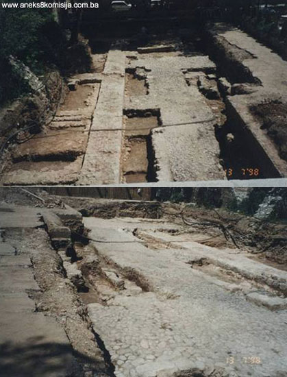
2. Description of the property
The remains of Tašlihan consist of walls, flooring composed of bricks with lime mortar infill, and stone slab and cobble paving. Clearing of the quadrants discovered in the first investigations began in 1998, proceeding systematically from the southernmost quadrant, 108,and northern 59, followed by 110, 109 and 69, then the row of 79, 89 and 99, and finally 58, 68, 78,99 and 98 as a whole. This was followed by the excavation of quadrants 116, 106, 96, 87, 77, 68, 58, 45, 46 and 47 and quadrants 85, 86 and 75. The area in quadrants 108 and 109 on which areas of brick and some stone structures had been drawn when the first archaeological investigations were conducted was not found. The original excavated area of 10 x 30 m that was investigated constitutes about 1/5 of the former premises. The only complete wall at the excavated site is wall (B), which runs north – south almost parallel with the west wall of the bezistan. It is 22m in length and 1.30 m thick. At its extreme southern end, it bends slightly towards the west over a length of 4.0 m, and narrows to a thickness of 1.0 m. The average height of the wall is 0.20 m. To the east are three walls at right-angles to it, with average length of 2.0 m. Only the substructure of the walls has survived, apart from wall B1 with a height of 0,30 m.
Two parallel walls were excavated at the southern side of the site. The northerly wall (C) is 9.0 m long, and the southerly wall (A) is 12.5m long. Together with wall B and its parallel wall A1, they form a square room P5 (measuring 4.0 x 4.0 m).
At the far northern edge of wall B, there is a wall consisting of one course of stones in mortar, which runs eastwards and westwards from wall B. This thin wall was probably the southern edge of the cobbled passage that led towards the entrance to the bezistan, now closed off. (M. Gavrilović, 1998, 3).
The far north-eastern walls, E and D, formed a T shape. These two walls and part of wall B together with B3, as well as areas 2a and 2b, are set almost symmetrically to the former entrance to the bezistan.
Along the western side of wall B, two rectangular areas were formed: 2d (measuring 5.40 x 1.70 m) and 2c (6.30 x 1.70 m), enclosed by thin walls built of stones of different types and shapes, ranging in thickness from 0.20 to 0.60 m. These two rooms were part of the later construction that was partly responsible for wrecking the cobbled paving. A thick layer of soot was found beneath them, at a depth of 1.30 – 1.55m. Wall G (11m long and 1.30 m thick) was discovered to be parallel with wall B, 4m to the west, and wall F was discovered as a continuation of wall G northwards. These two walls have not been sufficiently excavated, as access was impossible without extending the dig. One thin wall 1.20 m in length (identical to those of 2c and 2d) was found at the upper edge of the wall, at a depth of 1.26 m.
The walls are 1.30 m thick, and the foundations range from 1.70 to 1.80 m thick. The maximum height of the walls is 1.0 m. The depth of the footings varies from 1.97 m (wall A) in the southern area of the trial dig, to 1.66 m northwards (B3). Interventions were observed on the southern part of the upper area of wall A, as well as behind it towards the south and north. At the northern part of the wall, next to the western profile (P1), there was a step? 0.6m long the depth of which takes up half of the thickness olf wall (A). The bottom of the step? was edged with bricks set in a U shape, with a flooring of a thick layer of mortar between the bricks. Part of the flooring by the south face of the wall (P2) was also edged with bricks and mortar. Flooring P3, formed of tufa blocks, was found to the east. A path of stone slabs and mortar was found at a distance of 2.5m. this is 0.15 m in height and 1.0 m in width.
Two courses of bricks were discovered on the upper surface of wall A (next to area P3). Within the western half of area P5, enclosed by walls A, A1, C and B, the flooring of bricks, with additional flagstones at the northern edge, had survived. The same type of flagstones, the remains of flooring, were also discovered in P6. P7, to the east of wall B, has a floor consisting of two stone slabs, as well as a flooring of fragments of brick (P8). Some sort of flooring of brick fragments was also observed in places above the cobbles themselves. All the floors were covered with a thick layer of soot.
The cobbles extends over much of the site, and shows signs of considerable age, given that it had suffered here and there which was patched up in a way that does not match the main structures. It runs to the north from wall C, towards wall B, and as a wide strip to the northern part of the dig. One leg, 2 m wide, runs towards the eastern entrance to the bezistan and along the western side of wall G. Its entire surface is covered with soot, and especially the western side of wall B, and along 2b and 2c.
A new feature of the later excavations was flooring composed of laid stone running along the length of wall A2, which was presumed to be part of the entrance to Tašlihan. Below it was a layer of similar paved flooring, probably older. Wall H was identified by tracing walls H1, H2, H3, H4, H5 and along them parallel with wall A. These walls create five identical areas.
After excavating quadrants 116, 106, 96, 87, 77, 68, 58, 45, 46, 57 and quadrants 85, 86 and 75, it was found that there were no further architectural remains, meaning that this was the end of the surviving area of Tašlihan. Later works probably had the effect of destroying the foundations of Tašlihan and of the masjid (everyday mosque) in the middle of the complex.
Building techniques
The walls were built of regularly-shaped quarry limestone. The outer faces of the walls were laid in regular courses, some 0.15m high, with a rubble infill between. The foundations were made of quarry stone, both large and small stones, mixed with substantial quantities of lime. Two parallel, rectangular channels, or air ducts, 0.15 m in diameter, were formed in the foundations. Lime mortar with an admixture of coarse sand was used as binder. It is suggested that a detailed analysis of the mortar be carried out. The widening of the walls in the foundations themselves varies in width. There was also a layer of red soil mixed with river pebbles.
The provenance of the bricks used as flooring has not been established. The bricks are red-baked, and of two different sizes: 33 x 16 x 4 cm and 28 x 15 x 3 cm.
Archaeological material
Large quantities of recent material were found: ceramic tiles, moulded glazed tiles from a stove, various sorts of glass – flat glass, window glass, reinforced glass – and pieces of porcelain dishes, glasses, etc. These remains were particularly abundant in the eastern half of the dig, to a depth of 1.1cm.
- iron key, 19.5cm long;
- some fragments of typical glazed ceramics, parts of various dishes;
- quantities of fragments of small glass dishes of different colours: light blue, blue, light green, and clear;
- small clay pipes in pieces, 15 in all. A larger group of the same type was found in the thick layer of soot in 2d – right next to wall B;
- two silver coins from 1569(3), Maximilian II (1564 – 1576) with well preserved and legible text. Together with the coins, there were the covers of some small, thin wooden object, clad with thin sheet copper with reliefs;
- three coins from 1882, found directly above the cobbled paving.
The archaeological excavations found almost no iron artefacts used to join structural timbers – just two large nails and three pieces of reinforcement were found.
It was found that almost the entire eastern half of the dig has suffered recent damage, which had the immediate effect of levelling it almost down to the foundations. This damage was also exacerbated, in part at least, by earlier building works, mainly relating to laying floors P7 and P8 and areas 2c and 2d, as well as to defining the now closed-off western entrance to the bezistan. Some levelling in the southern part of the dig also represents a secondary intervention. There may once have been an entrance with a staircase there, built immediately after the first fire, or most likely after 1831. One piece of evidence in favour of this hypothesis is the underfloor in P5. Another is the existence of brick flooring, since bricks certainly appeared only later in the life of the building. The only wall to survive over its entire length, wall B, together with walls C, A, B1, B2 and B3, and the eastern reconstructed walls C, A, A1, B1, B2 and B3, and the eastern reconstructed wall of the bezistan, form a logical architectural and spatial ensemble, recognizable as a single entity in the way it was built, both above and below ground. It would seem, for now at least, that G and F, which have not yet been fully identified, might also form part of this ensemble, and were probably intended to define the centre of the courtyard (a sebilj [fountain]?). The presence of cobbles that remained in use in the property over a long period is also somewhat puzzling. Archaeological excavations at the southernmost line of the cobbles revealed a thin layer of soot in the profile immediately beneath the cobbles.
Old photographs reveal that the eastern part of the building was in use even later, which was also confirmed by the archaeological excavations. Taking into consideration the length period over which it remained in use, and the size and former importance of Tašlihan, the archaeological excavations conducted so far have yielded important but still inadequate results. (M. Gavrilović, 1998, 7). Tašlihan was an irregular rectangle in plan, as was typical of all two-storey caravanserais. Unlike other hans, where the main purpose of the courtyard was to load and unload goods, the Tašlihan courtyard housed a whole row of different shops, which characterized it as a trading han. The shops in the southern part of the site were formed during some later stages of construction. A sebilj with several spigots was built in the courtyard, and a mosque with pillars was built right behind it. (Ć. Truhelka, 1912, 188). There were two staircases close to the main entrance to the han, leading from the courtyard to the rooms and corridor on the first floor. The rooms were roofed with small domes, and the corridors were barrel-vaulted. The roofs were clad with sheet lead.
Minor archaeological artefacts from the 2007 excavations
Most of the minor archaeological finds were surface finds ranging in date from the late 16th century to the recent past. The types found were clay pipes, fragments of earthenware vessels, fragments of glazed tiles with relief from a stove, glazed tiles from a built-in stove, fragments of porcelain dishes, fragments of glass, iron nails and cramps, builder’s hardware, coins, tokens, metal buttons and costume jewellery. The clay pipes, of which 8 were found, are one of the few finds that could probably be dated after detailed study. There are four types of pipe. The first are typically bright red in colour with floral designs (table I, illus. 1-3). They were found on the floor of quadrant 100 by the east wall, at a depth of 1 m. The second group consists of pipes ranging in colour from black to dark green (table I, illus. 4-5), found on the floor in the corner of east wall A in quadrant 110, at a depth of 0.90 m. The third group of pipes is dark grey and of characteristic shape (table II, illus, 1-2). These were found by the east wall at a depth of 0.95 m on the edge of quadrants 110 and 120. The fourth group consists of black pipes with a characteristic neck (table II, illus. 3), found on the same spot as pipes 1 and 2.
Other material of Ottoman origin, apart from the pipes, consists of fragments of pottery vessels found by the edge of wall A1 in quadrant 97, at a depth of 0.98 m (tables III, IV and V). The fragments shown in table III illus. 1-5 probably belong to the same vessel. Tables IV and V show fragments of various vessel: unglazed (table IV, illus. 1 and 4), with a distinctive green glaze (table IV, illus. 2 and 3), with a light brown glaze (table V, illus. 1-3) and, of particular interest, a brown-glazed fragment with an interesting ornamental design (table V, illus 4). Also of Ottoman origin is a gold akča coin (table XV, illus. 1 and 2), found by the eastern edge of wall H3 in quadrant 118, at a depth of 0.85 m. A gold pendant with Arabic script was found at the same spot (table XV, illus. 4 and 5), probably dating from the 20th century. Iron artefacts – nails, cramps and hardware (tables X and XI) – were found on the cobbles by the northern edge of wall C in quadrant 97.
The glass found was too fragmented to be able to comment on it without detailed analysis.
Fragments of relief glazed tiles from a built-in stove (tables VI and VII) were found in quadrant 70, by the east wall of Tašlihan, at a depth of 0.70 m. All these fragments are green except for the one in table VI, illus 7, which is brown. Fragments of glazed stove tiles were also found by these relief tiles (table VI, illus 3 and 4). Fragments of a white porcelain dish with blue floral design (table VIII) were fond in quadrant 107 on wall A. Like the material shown in tables V and VII, that shown in table VIII also belongs to the Austro-Hungarian period. A bronze medallion (table XVI), belongs to the time of the Kingdom of Yugoslavia. The obverse of the medallion has an inscription in Cyrillic and Latin script, „to a good marksman, and the reverse bears a crown, two decorated guns with a target in the middle, and a garland. The medallion was found in the corner of walls H5 and A in quadrant 107, at a depth of 0.50 m. Also from the time of the Kingdom of Yugoslavia is a necklace (costume jewellery) of imitation silver coins dating from 1903, with the profile and inscription of „Milan M Obrenovič IV, Prince of Serbia.“
The most recent items are shown in tables XII and XIII – chips from the casino in the Hotel Europe (table XII) and a metal button and 50 dinar coin dating from 1955. This material was found on the top of wall H in quadrant 117.
3. Legal status to date
The archaeological site of the remains of Tašlihan is registered as a monument of culture and listed in the register of monuments of the Sarajevo Cantonal Institute for Protection of the Cultural and Historical Heritage.
The Provisional List of National Monuments includes the archaeological site under the heading Sarajevo – archaeological site of Tašlihan, numbered as 534.
The Regional Plan for BiH to 2000 lists the archaeological site of Tašlihan within the urban ensemble of Sarajevo, which is a Category 0 monument.
4. Research and conservation and restoration works
Field research, led by archaeologist Margita Gavrilović, was conducted between 8 June and 13 July 1998, as part of the project for the repair, reconstruction and extension of the Hotel Europa. The area investigated was on the eastern plateau of the hotel, next to the western wall of the bezistan. The final dig covered an area of 10 x 30 m. The purpose of the excavations was to establish the presence of architectural remains of the former Tašlihan.
The conclusion reached on the basis of these excavations is that the han extended as far as below the extension and even part of the old Hotel Europa.
The archaeological material is house in the premises of the Sarajevo Cantonal Institute for Protection of Cultural, Historical and Natural Heritage. It has not been studied so far due to lack of data, which might be gathered by extending the area of the dig.
Between 9 and 21 July 2007 the Museum of Sarajevo carried out systematic archaeological investigations on the Tašlihan site. The area investigated was that to the east of the Hotel Europe. The systematic archaeological investigations were preceded by layout out a geodetic grid adjoining the existing grid. The quadrants were 5 x 5 metres in size. The remains of the walls and foundations found between 8 June and 13 July 1998 by the team headed by Margita Gavrilovič were cleared. The team consisted of Museum of Sarajevo staff: archaeologists Adnan Muftarević and Mirsad Avdić, the museum's draftsman, curator Hamdija Dizdar, architect Aida Sulejmanagić, and conservator Taib Kešmer. The investigations were funded by Europa d.d.
The site was surveyed by photogrammetry, which was used to determine and document all height levels, profiles and changes over time to the Tašlihan building. The photogrammetric survey was conducted by IGA-plan d.o.o. Ilijaš.
5. Current condition of the property
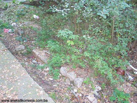
During an on-site inspection in October 2004 the following was ascertained:
The archaeological site was neglected, overgrown with tall vegetation and quantities of waste matter. The remains of the walls could be seen only in the southern part of the site.
The archaeological site to the west and north of the remains that had been uncovered was partly covered by a parking area, the former garden of the hotel, which has been destroyed.
During an on-site inspection on 31 July 2007 the following was ascertained:
- the Tašlihan site that has been archaeologically excavated has an improvised barrier in the shape of plastic tape
- for safety reasons, arising from the building works on the Hotel Europa, it was forbidden to go any closer.
III - CONCLUSION
Applying the Criteria for the adoption of a decision on proclaiming an item of property a national monument (Official Gazette of BiH nos. 33/02 and 15/03), the Commission has enacted the decision cited above. The decision was based on the following criteria:
A. Time frame
B. Historical value
C. Artistic and aesthetic value
iv. Composition
v. Value of details
D. Clarity (documentary, scientific and educational value)
i. Evidence of historical changes
iv. Evidence of a certain type, style or manner
G. Authenticity
i. Form and design
v. Location and setting
H. Rarity and representativity
i. Unique and rare example of a certain type or style
The following documents form an integral part of this Decision:
- Copy of cadastral plan
- Photo-documentation
- Documentation of the Sarajevo Cantonal Institute for Protection of Cultural, Historical and Natural Heritage:
- Report on the results of the field archaeological research at the site of Tašlihan, Sarajevo, July 1998, Gavrilović, Margita
- Elements of the Tašlihan reconstruction, Sarajevo, August 1998
Bibliography
1912. Truhelka, Dr Ćiro, Gazi Husrevbeg, Jnl of the National Museum XXIV, Sarajevo, 1912, 186-189
1990. Kreševljaković, Hamdija, Hanovi i Karavansaraji (Hans and Caravanserais), Selected Works II, Sarajevo, 1990, 241 – 319.
1997. Zlatar, Behija, Zlatni period Sarajeva, (Golden Age of Sarajevo), Supplements on History, Sarajevo, 1997.
2007. Study of systematic archaeological investigations of Tašlihan (16th c.), Museum of Sarajevo
(1) inventory of the former City Authorities in Sarajevo.
(2) Invitation was sent in 1542 or 1543 (facsimile of the document in the Sarajevo City Museum, no. M.K. 604)
(3) These are probably the oldest archaeological material discovered. (M. Gavrilovic, 1998, 6)
|