Status of monument -> National monument
Pursuant to Article V para. 4 Annex 8 of the General Framework Agreement for Peace in Bosnia and Herzegovina and Article 39 para. 1 of the Rules of Procedure of the Commission to Preserve National Monuments, at a session held from 6 to 10 July 2004 the Commission adopted a
D E C I S I O N
I
The historic urban area of Jajce is hereby designated as a National Monument of Bosnia and Herzegovina (hereinafter: the National Monument).
The National Monument consists of all the buildings within the historic urban area (Zone 1 – area of characteristic structure and historical and architectural value, the part of the town that has preserved its integrity and authenticity to the greatest extent, and which should be the subject of strict control), which is bounded by:
to the south:
The southern slopes of the tufa mound of Varošnica from the Radio Jajce building and intersection with Pijavice street, to the east over the arched bridge on the river Vrbas to the Jajce-Banja Luka road.
to the west:
Pijavice street over the new bridge on the river Pliva, along Ivo Lola Ribar street to the intersection with Zagrad street, along the same street to the north to the intersection with Harmani street and in a straight line to the north towards Rado Marjanac street.
to the north;
Along Rado Marjanac street to the intersection with Marshal Tito street, including the buildings of the Orthodox church of the Most Holy Mother of God and the Franciscan monastery and the site and remains of the church of the Blessed Virgin Mary.
to the east:
Along Proleterskih brigada street from the Franciscan monastery to the bridge over the Vrbas at Kozluk and south to the arched bridge.
The individual structures of monumental or environmental value within the historic urban area are:
Religious buildings
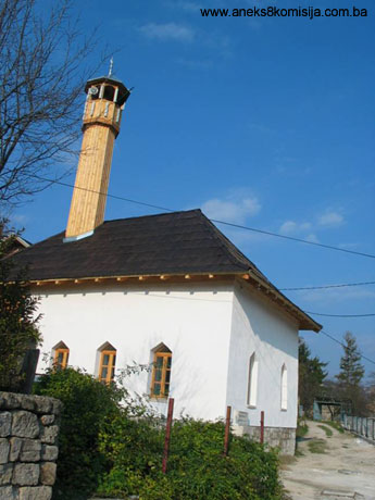
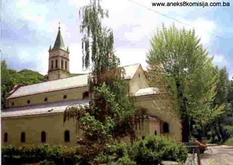
The Mithraic Temple, the historic monument of the Catacombs, the church of St Mary with St Luke’s belltower, the site and remains of the Esma Sultana mosque, the historic monument of the Sinan beg or Okić mosque, the historic monument of the Dizdar’s or Women’s mosque, the architectural ensemble of the Ibrahim beg or Pijavice mosque, the historic monument of the Šamić mosque, the site and remains of the architectural ensemble of the parish church of the Blessed Virgin Mary and the Franciscan monastery, the site of the Jewish synagogue, the site and remains of the architectural ensemble of the Orthodox church of the Most Holy Mother of God,
Fortifications
The Jajce fortress with the Clock Tower, northern perimeter ramparts (from the north-east corner of the fortress to Mračna kapija-Velika tabija (gatehouse and bastion), Mračna kapija, Velika tabija, the wall from Velika tabija to the tower at Džikovac, the Tower at Džikovac, the wall between the tower at Džikovac and Papaz tower, Papaz-tower, the Banja Luka gatehouse, the wall between the Banja Luka gatehouse (Papaz gatehouse) and Šamić tabije, Šamić tabija, the wall between the Vrbas and Šamić tabija, the western perimeter rampart (the wall from the fortress to Medvjed tower, Medvjed tower, the wall south of Medvjed tower to the Pliva), the east and south sides of the perimeter walls (Travnik gatehouse).
Bridges
The iron bridge over the river Pliva
Memorials, burial grounds and mausolea
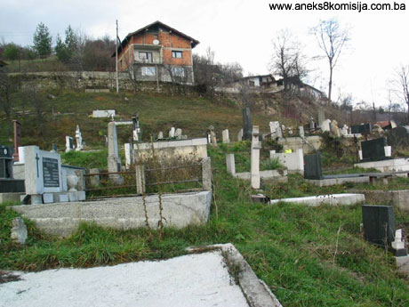
The site of the cemetery in Varošnice
Residential buildings
The historic building of the Omerbeg house, the site and remains of the historic building of the Burić house, the site and remains of the historic monument of the house of the Kršlak family I and the remains of the historic monument of the house of the Kršlak family II, the site and remains of the historic building of the Dizdar’s house, the site of the historic monument of the Mulalić house, a house in Gornja Mahala, and an architectural ensemble dating from the Austro-Hungarian building consisting of the Sarač house or Šarenica, Building I of the primary school and the Finance House.
World War II memorials
The National Bank building, the Emanuel Lihtner building, the Elektrobosna factory Shelter, the site and remains of the ZAVNOBiH villa
Other buildings and sites
The site of the Musafirhana in Jajce, the historic monument of the Hafizadića česma drinking fountain, the česma outside the Sinan beg mosque, the mills, the remains of the hamam in the čaršija, the building of the first pharmacy or Ćelebić house, the historic monument of the AVNOJ Centre (Soko [Falconry?] Centre)
Natural heritage sites
The tufa mound of Varošnica, the tufa mound and caves in the tufa on the left bank of the river Pliva, the beds of the rivers Pliva and Vrbas, and the waterfall on the river Pliva.
The provisions relating to protection and rehabilitation measures set forth by the Law on the Implementation of the Decisions of the Commission to Preserve National Monuments, established pursuant to Annex 8 of the General Framework Agreement for Peace in Bosnia and Herzegovina (Official Gazette of the Federation of BiH nos. 2/02, 27/02 and 6/04) shall apply to the National Monument.
II
The Government of the Federation of Bosnia and Herzegovina (hereinafter: the Government of the Federation) shall be responsible for ensuring and providing the legal, scientific, technical, administrative and financial measures necessary to protect, conserve, display and rehabilitate the National Monument.
The Government of the Federation shall be responsible for providing the resources for drawing up and implementing the necessary executive regional planning documentation for the National Monument.
The Commission to Preserve National Monuments of Bosnia and Herzegovina (hereinafter: the Commission) shall determine the technical requirements and secure the funds for preparing and setting up signboards with the basic data on the monument and the Decision to proclaim the property a National Monument.
III
The Government of the Federation shall be responsible for drawing up a detailed plan for the protection of the historic centre of Jajce. The detailed protection plan shall relate to the whole area and to individual buildings within the protected area as defined in Clause 1 of this Decision.
Protection level I consists of the area defined in Clause 1 of this Decision and relates to the buildings and areas of value as monuments or of high townscape and natural value.
Individual buildings and architectural ensembles:
on the right bank of the river Pliva:
The historic monument of the AVNOJ Centre, cadastral plot nos. 1019 and 1020, cadastral municipality Pijavice, the architectural ensemble of the Ibrahimbeg mosque, c.p. no. 1023, c.m. Pijavice, the site of the cemetery in Varošnica, c.p. nos. 1146/1, 1148, 1150, being c.p. nos. 536/1, 537/1 and 546 old survey, c.m. Jajce I;
on the left bank of the river Pliva:
the site and remains of the architectural ensemble of the Esme Sultan mosque, c.p. nos. 1251, 1252 and 1253, c.m. Jajce I, the historic monument of the Sinanbeg mosque, c.p. no. 926, c.m. Jajce I, the historic monument of the Dizdar’s or Women’s mosque, c.p. no. 937, c.m. Jajce I, the historic monument of the Catacombs, c.p. nos. 879 and 880, c.m. Jajce I, the architectural ensemble of St Mary’s church and St Luke’s bell tower, c.p. n. 989, c.m. Jajce I, the site and remains of the historic monument of the Burić house, c.p. nos. 881 and 882, c.m. Jajce, the site and remains of the historic monument of the Kršlak-Kapetanović house, c.p. no. 1203, c.m. Jajce I, the site and remains of the historic monument of the Kršlak house, c.p. o. 1232, c.m. Jajce I, the site and remains of the historic monument of the Musafirhan in Jajce, c.p. no. 1175, c.m. Jajce I, the architectural ensemble of the Omberbeg house, c.p. no. 980/1, c.m. Jajce I, the historic monument of the Hafizadić česma, c.p. no. 980/1, c.m. Jajce I, the site and remains of the Šamić mosque, c.p. no. VIII/28, c.m. Jajce I, the site and remains of the church of the Blessed Virgin Mary and the Franciscan monastery, c.p. no. 778 and 780/1, c.m. Jajce I, the site and remains of the church of the Most Holy Mother of God.
Fortifications (fortress, ramparts and towers) and protection zone:
The architectural ensemble of the fortress (Citadel), c.p. no. 538, c.m. Jajce I, the Travnik gate, c.p. no. 980/2, c.m. Jajce I, the Medvjed tower, c.p. no. 1002, c.m. Jajce, the Clock tower, c.p. no. 933, c.m. Jajce I, the Mračna tabija, c.p. no. 1226, the Banjaluka gate, c.p. no. 1234, c.m. Jajce I, the Šamić tabija.
Sites of high townscape value:
Zone around the western ramparts, Medvjed tower, Catacombs, St Mary's church and St Luke's bell tower: consisting of c.p. nos. 863, 864, 865, 867, 868, 879, 880, 881, 882, 883, 884, 885, 886, 972, 973, 974, 975, 976, 977, 978,979, 980, 981, 982, 983, 984, 985, 986, 987, 988, 989, 990, 991, 992, 993, 994, 995, 996, 997, 998/2, 999, 1000, 1001, 1002, 1003, 1004, 1005,
Residential area by the Clock tower: consisting of c.p. nos. 920, 921, 931, 932, 933, 939, 952, 953, 954, 955, 1203, 1204, 1205, 1219, 1220,
Residential building in Varoš: c.p. no. 760
Sites of high natural value – natural monuments:
Tufa mound of Varošnica
Tufa mound and caves in the tufa on the left bank of the river Pliva
Bed of the river Pliva: from the new bridge to its confluence with the river Vrbas
River Vrbas: from the arched bridge to the bridge linking Varoš and Kozluk
Waterfall on the river Pliva
In this protection zone the following measures are hereby stipulated:
1. Conduct an analysis of the current situation, including:
Ÿ a chronological presentation and stylistic valorization of existing buildings,
Ÿ an overview of the number of storeys of existing buildings,
Ÿ the materials used,
Ÿ the degree of damage or preservation,
Ÿ an overview of current use of the buildings.
2. Based on the analysis of the current situation, draw up a rehabilitation project to include the restoration of the historical environment, with the implementation of the following measures:
Ÿ the retention, repair, conservation, making good and display of existing architectural structures and urban elements of importance as monuments or with townscape/landscape value
Ÿ the restoration and reconstruction of historic buildings, forms and areas that will reinforce the townscape importance of the historic centre of Jajce as a whole; it shall be mandatory to retain or restore the original appearance of the buildings (horizontal and vertical dimensions, proportions, number, size and arrangement of doors and windows, architectural details and colours of walls, paving, doors and windows, treatment of facades and street-facing courtyard walls
Ÿ all interventions and methods used must respect all the typological and architectural features of the building in question
Ÿ all methods used and degrees of intervention must be recorded
Ÿ all buildings on which rehabilitation works are carried out must respect the building line of neighbouring buildings at both ground and upper floors
Ÿ the eaves above doors and windows, projecting roof eaves and guttering may exceed the building line by up to one third of the width or the street or no more than one metre
Ÿ clearing and removal of later additions to buildings or of buildings not in harmony with the environment; alter individual features on buildings resulting from later interventions (replacing gabled roofs by hipped roofs, removing balconies and loggias, replacing large ground floor shop windows by smaller ones)
Ÿ regulate the size and arrangement of doors and windows, replace iron, aluminium and plastic window frames with wood, respect traditional design and colour schemes
Ÿ construction on protected green areas, streets, squares and other public spaces is prohibited
Ÿ no permits may be granted for building, building/artisanal or artisanal works without the approval of the Federation ministry responsible for regional planning (hereinafter: the regional planning ministry) and the expert supervision of the heritage protection authority of the Federation of Bosnia and Herzegovina (hereinafter: the heritage protection authority).
Use of materials and forms on buildings being rehabilitated:
Ÿ When rehabilitating, use original materials (bedrock, miljevina limestone, breccia, tufa and schist/slate), traditional bonding materials (hydraulic lime mortar) and traditional building methods wherever possible
Ÿ Exterior treatment of surfaces: lime mortar plaster and whitewash
Ÿ Use of wood: pine, deal, juniper, chestnut, beech and oak; the lower sides of projecting roof eaves shall be of wooden beams and boards and shall be visible, except in the case of buildings from the Austro-Hungarian period
Ÿ The type and pitch of the roof must match the original condition of the building: gabled or hipped roofs, wooden roof timbers with a pitch of 30 to 60 deg.)
Ÿ Guttering shall be installed from the exterior.
Interior of buildings
Ÿ Interior alterations to existing buildings shall be permitted to adapt them to modern living and working conditions and new use interventions to the interior arrangement and fittings, the installation of utilities, bathrooms and modern fixtures and fittings
Ÿ The interpretation and transformation of the design of details is permitted only in the interior, with the use of high quality materials or outstanding design
Use of buildings
Ÿ Regulate the ground floors of the buildings, by restoring their original use or introducing new uses appropriate to the central urban zone – small-scale catering or service facilities, traditional crafts that do not pollute the environment, or cultural and educational use
Ÿ Change of use in the case of residential buildings is permitted for catering, commercial, academic, educational or cultural purposes and for traditional crafts that do not pollute the environment. At least 60% of the buildings must be retained for residential use
Ÿ The introduction of new uses inappropriate to the traditional functions applicable to this urban zone (business, trade, catering and religious), uses that could have the effect of altering the character of the environment and the features that provide that character, and environmentally polluting uses is prohibited
INFRASTRUCTURE AND STREET FURNITURE:
Ÿ The introduction of modern sanitary and hygienic technical devices is permitted provided it is in a way that will not affect the exterior appearance of the buildings
Ÿ Regulate road traffic; ban heavy goods traffic exceeding two tonnes in Protection Zone 1
Ÿ Set the central pedestrian zone in order by designing and installing street lighting and street furniture in harmony with the architectural and typological context of the zone) so as not to jeopardize the townscape value of the area; the installation of classic electric street and advertising lighting only is permitted, with the lit-up features appropriate to the surroundings (lanterns for street lighting, suitable floodlighting for individual monuments and environments)
Ÿ Draw up a rehabilitation project for the old roads network – carry out conservation and repairs to sokaks (small streets, side streets) and dry-stone retaining walls
Ÿ Conduct an analysis of street fronts – a detailed survey of the current condition, study and identification of their complexity – and draw up a detailed plan for interventions designed to preserve the character of the street
Ÿ Conduct an analysis of open areas – conduct a detailed survey of the current condition and draw up a detailed plan for interventions designed to preserve their character
Ÿ The erection of billboards, advertisements and signs that spoil the view or clash with the townscape is prohibited
Ÿ Signs, billboards and shopfronts may not exceed the ground floor in height nor project beyond the building line, except in the case of eaves and roofs, which may project by a maximum of one metre. Exterior frames should match the traditional design and materials (wood or painted metal). The use of plastic or of unpainted steel or aluminium for this purpose is prohibited. The use of large billboards, neon lighting or billboards made of plastic materials is prohibited
Ÿ The construction of major infrastructure facilities is prohibited.
NATURAL HERITAGE:
Ÿ Draw up a rehabilitation project for the existing infrastructure network with particular emphasis on mains water and sewerage installations – build a waste water treatment plant to protect the water course of the river Pliva and tufa-generators
Ÿ Draw up a detailed plan for the regulation of the river Pliva from the lakes to its confluence with the Vrbas, taking townscape and natural values into consideration
Ÿ The exploitation of the natural resource of the tufa in the zone defined in Clause 1 is prohibited
Ÿ Existing high vegetation and certain species of plant shall be retained
Ÿ Draw up a detailed plan for the landscaping of the banks of the Pliva and Vrbas and their use for public purposes (sport and recreation)
Ÿ Draw up a project for the greening and landscaping of courtyards, gardens and public spaces, using indigenous plant species.
PROTECTION MEASURES APPLICABLE TO INDIVIDUAL BUILDINGS:
Fortifications (fortress, ramparts and towers)
Ÿ Conduct an analysis of the stability of the existing structure of the walls and towers
Ÿ Repair damage resulting from many years' lack of maintenance and damage resulting from mechanical impact
Ÿ Prevent extensions to residential buildings by the walls of the fortifications by introducing a protection zone 1.50 metres wide around each building
Ÿ Prevent unchecked new construction in the area below the fortifications
Ÿ Define the zone of archaeological excavations
Ÿ Define a programme to display the said properties,
Ÿ The protection measures stipulated by the respective Decisions apply to each individual property designated as a national monument
Residential buildings in Gornja Mahala
Ÿ Conduct an analysis of the stability of existing construction
Ÿ Make the buildings safe before any consolidation works are carried out
Ÿ Repair roof timbers and roof cladding to prevent further damage to the structure of the buildings from the elements and damp
Ÿ Draw up a rehabilitation project for damaged and collapsing buildings
Ÿ Valuable examples of interior decoration require particular care when carrying out interventions; the building in question should be closed to prevent items being removed
Ÿ The protection measures stipulated by the respective Decisions apply to each individual property designated as a national monument
Šamić mosque
Ÿ Conduct investigative works including a survey of the existing condition of the building and an analysis of damage
Ÿ Carry out works to discover original fragments
Ÿ Provide proper protection for the mihrab, crown of the walls and original fragments that are found
Ÿ Draw up a rehabilitation project for the building
Protection Zone II consists of the area constituting a contact zone with the zone in which buildings of value as monuments and areas of high townscape/landscape value are located.
The residential area of Gornja mahala below the citadel consists of the area bounded to the north by the Fortress (citadel), to the south by E. Ademović street as far as the intersection with Tito street, and to the east along Kesten Mehmed street towards the Banja Luka gate.
The Varoš zone, includes the Hadanan mosque c.p. no.. 728, a row of shops: c.p. nos. 729, 730, 731, 732, 733, 734, 1339, 1340, 1341, 1342, 1343, and houses, c.p. nos. 761, 765/1, 765/2, 766, 767, 768, 1310, 1311, 1312, 1313, 1314, 1315, 1316, 1318, 1319, 1320, 1321, 1322, 1323, 1324/1, 1324/2, 1326/1, 1327/1, 1327, 1329, 1330, 1331, 1332, 1332/1, 1332/2, 1333, 1334, 1335, 1336, 1337, 1338.
In this zone, as well as reconstruction, the interpolation of new buildings or parts thereof may be approved subject to the following conditions:
Ÿ The maximum permissible height of buildings is the maximum height of adjacent buildings, and in any case not exceeding or 6.5 m to the height of the roof frame, depending on the historical neighbourhood of the building (the zone in which it is located), and maximum permitted horizontal dimensions of 8 x 8 m, with the use of traditional materials (stone and whitewashed plastered walls, shingles or sheet metal roof cladding, roof pitch of 30 to 60 degrees, timber construction, the use of cant strips to ease the transition from the steep roof to the eaves, the use of dormer and oriel windows); the buildings shall not clash in proportions or colour scheme with buildings that have townscape value
Ÿ The heights of storeys in existing traditional buildings shall be retained even if they differ from official regulations
Ÿ The overall impression of new structures must reflect the townscape identity but new features of contemporary design and materials are permitted if they are in harmony with the structure and surroundings
Ÿ All buildings must respect the building line of neighbouring buildings at both ground and upper floors
Ÿ The construction of industrial facilities and facilities the use of which could jeopardize the national monument, and the siting of quarries and environmental polluters are prohibited
Ÿ Infrastructure works are permitted only with the approval of the regional planning ministry and to the conditions stipulated by and under the expert supervisio of the heritage protection authority.
Protection Level III relates to buildings and areas with no value as monuments or townscape/landscape value. This level of protection is applicable to the part of the čaršija with the newly-built trade centre, cultural centre, community housing around Hrvoje Vukčić Hrvatinić street from the Travnik to the Jajce gates.
In the areas with this level of protection new building may be approved on condition that newly-erected buildings do not jeopardize the value as monuments or the natural or townscape/landscape value of other areas in size, appearance or any other way.
IV
All executive and area development planning acts not in accordance with the provisions of this Decision are hereby revoked.
V
Everyone, and in particular the competent authorities of the Federation of Bosnia and Herzegovina, the Canton, and urban and municipal authorities, shall refrain from any action that might damage the National Monument or jeopardize the preservation and rehabilitation thereof.
VI
The Government of the Federation, the regional planning ministry, the heritage protection authority, and the Municipal Authorities in charge of urban planning and land registry affairs, shall be notified of this Decision in order to carry out the measures stipulated in Articles II to V of this Decision, and the Authorized Municipal Court shall be notified for the purposes of registration in the Land Register.
VII
The elucidation and accompanying documentation form an integral part of this Decision, which may be viewed by interested parties on the premises or by accessing the website of the Commission (http://www.aneks8komisija.com.ba)
VIII
Pursuant to Art. V para 4 Annex 8 of the General Framework Agreement for Peace in Bosnia and Herzegovina, decisions of the Commission are final.
IX
On the date of adoption of this Decision, the National Monuments shall be deleted from the Provisional List of National Monuments of Bosnia and Herzegovina (Official Gazette of BiH no. 33/02, Official Gazette of Republika Srpska no. 79/02, Official Gazette of the Federation of BiH no. 59/02, and Official Gazette of Brčko District BiH no. 4/03), where they featured under serial nos. 272-282.
X
This Decision shall enter into force on the date of its adoption and shall be published in the Official Gazette of BiH.
This Decision has been adopted by the following members of the Commission: Zeynep Ahunbay, Amra Hadžimuhamedović, Dubravko Lovrenović, Ljiljana Ševo and Tina Wik.
Chair of the Commission
Ljiljana Ševo
No: 08.2-6-1042/03-
7 July 2004
Sarajevo
E l u c i d a t i o n
I – INTRODUCTION
Pursuant to Article 2, paragraph 1 of the Law on the Implementation of the Decisions of the Commission to Preserve National Monuments, established pursuant to Annex 8 of the General Framework Agreement for Peace in Bosnia and Herzegovina, a “National Monument” is an item of public property proclaimed by the Commission to Preserve National Monuments to be a National Monument pursuant to Articles V and VI of Annex 8 of the General Framework Agreement for Peace in Bosnia and Herzegovina (hereinafter: Annex 8) and property entered on the Provisional List of National Monuments of Bosnia and Herzegovina (Official Gazette of BiH no. 33/02) until the Commission reaches a final decision on its status, as to which there is no time limit and regardless of whether a petition for the property in question has been submitted or not.
Pursuant to the provisions of the law, the Commission proceeded to carry out the procedure for reaching a final decision to designate the Property as a National Monument, pursuant to Article V of Annex 8 and Article 35 of the Rules of Procedure of the Commission to Preserve National Monuments.
II – PROCEDURE PRIOR TO DECISION
In the procedure preceding the adoption of a final decision to proclaim the property a national monument, the following documentation was inspected:
Ÿ Data on the current condition and use of the property, including a description and photographs, data of war damage, data on restoration or other works on the property, etc.
Ÿ Documentation on the location and current owner and user of the property (copy of cadastral plan and copy of land registry entry)
Ÿ Historical, architectural and other documentary material on the property, as set out in the bibliography forming part of this Decision.
The findings based on the review of the above documentation and the condition of the site are as follows:
1. Details of the property
Location
Exact location: 44 , 5 , 22; 17, 16, 44
Jajce Municipality is in the central region of Bosnia and Herzegovina, Central Bosnia Canton, entity of the Federation of BiH. To the east it marches with Travnik Municipality, to the north with Dobratić Municipality, to the west with the municipalities of Mrkonjić Grad and Šipovo – Republika Srpska, and to the east with Donji Vakuf Municipality. It is 160 km from Sarajevo. The site has for centuries been a crossroads of the routes leading from the interior of the continent to the Mediterranean.
The municipality has 57 towns and villages and covers an area of 350 sq.km. The climate is moderate continental, with hot summers and mild winters with ample snow. The average January air temperature is –2 and the July average is 18.6 deg. C. The annual precipitation is 939 mm.
The town stands on a narrow fault valley extending along the north-west edge of Hum mountain at an altitude of1162 m. above sea level, at the confluence of the rivers Pliva and Vrbas. The geological nature of the site of the town and fortress is characterized by various formations. The surrounding mountains consist of mesozoic strata, and the valley in which the town is located is largely covered by diluvial and recent deposits of tufa as much as 60 m thick in places.
The entire complex with the fortress, town ramparts and towers lies on the southern slope of a large rocky pyramid, enclosed to the south-west by the bed of the river Pliva and to the south-east and east by the river Vrbas. The perimeter of the mediaeval town of Jajce is about 1300 m, with an area of 112,000 sq.m.
Historical information
To grasp the role and significance of the area and town of Jajce, certain basic details must be given of the wider region with common features, in other words of the area of Bosnia and Herzegovina.
Two elements were central to the formation of the historical and cultural physiognomy of Bosnia: its natural isolation, and its geographical position between the two great cultural domains of East and West. These powerful influences at times clashed violently, but at times intermingled to generate a third, indigenous stamp (Jadrić, 1970).
In the town of Jajce, there has been much building but also much demolition and destruction over the centuries. The town here is taken to mean the area within the mediaeval walls, which has been in existence from the mediaeval through the Ottoman period to the present day. There are few documents on the town's past, and no major archaeological excavations have been carried out. Our knowledge of the more distant past of the town thus remains fragmentary. Almost all archaeological finds have been accidental, usually in the course of digging the foundations for a new building, when carrying out conservation works, or as spolia built into later structures.
The most ancient traces of human habitation on the urban area of Jajce date from the Eneolithic age (locality Varošnice). Throughout the town, there are Bronze age remains in deep tufa cuttings, and also material traces of the later Iron Age (La Tene) (Bojanovski, 1988, 294; Marijanović, 1988, 179).
Prehistoric pottery has been found in tufa cuttings by the Museum of the 2nd Session of AVNOJ. These finds suggest the existance of a prehistoric settlement nearby, the location and chronological context of which have yet to be determined. When the foundations for the Social Centre were being dug, shards of prehistoric pottery dating from the late Bronze age (1250-800 BCE) were also found, washed down from higher land.
It is not yet known whether there was a prehistoric settlement on the site of the Jajce fortress, but its hilltop position and the pottery washed down to lower levels suggest this as a possibility.
The present extent of research is not sufficient to make it clear whether there was continuity of settlement in the transition from prehistoric times to antiquity. The oldest antique remains date from the third century and later, to the end of the sixth century. Antique bricks were found in Pijavice, opposite the former railway station, and a Mithraic temple below Volukja in the Bare residential area. When the five-storey block north of the Banja Luka gatehouse was being built, two late antique tombs and one vaulted sepulchre were found (4th to 6th century). To this should be added spolia of antique provenance built into the east wall of the fortress and the wall of St Mary's church, and finds on the site of the Post Office (Basler, 1963., 40-43)
The Mithraeum, bricks and sepulchre were on the edge of a late antique-era settlement in the valley at the confluence of the Pliva and the Vrbas, in the late mediaeval area outside the ramparts, on the plateau between the two town gates. Antique pottery was also found by the present-day police station, but this site was outside the settlement of that time.
In the antique era the site of present-day Jajce probably had a settlement with a customs post and an observation post for surveillance of the crossing over the Vrbas (Bojanovski, 1988, 296-297). The settlement was inhabited not only by the indigenous population but also by the Romanized descendants of the Pannonian tribe of Maezaei (Mezei) and foreigners, among whom were incomers from the eastern provinces of the Empire, whose community – to judge from the Mithraeum and the length of time it was in use – was a powerful one. The Romanized inhabitants respected cults, as far as is currently known from monuments to Jupiter Dolichenus and Silvanus (Pan). The surroundings of Jajce are rich in antique monuments, mostly discovered accidentally (Škegro, 2000, 14-15).
Sixteen grain pits or granaries were found on the site of the Social Centre. Based on similar finds elsewhere in Bosnia and Herzegovina, these pits were dated to the 4th to 7th century, but the absence of archaelogical material means that they cannot be reliably dated. It is known that such grain pits were still in use in the late mediaeval era in the region inhabited by Slav tribes and peoples. On the edge of this site a miniature 14th-15th century stećak tombstone was found (Basler, 1963, 48; Anđelić, 1963, 38-40).
The early mediaeval history of Jajce is poorly known. It was in the early mediaeval župa or county of Pliva, which is referred to as part of the then Croatian state by the Byzantine Emperor Constantine Porphyrogenitus in his De administrando imperio in the mid tenth century. The next reference to Pliva county in historical sources is not until 1366, when the Bosnian ban or ruler Tvrtko bestowed it on the Hrvatinić line, in the person of duke Vukac Hrvatinić, for his services in the defence of the town of Sokol three years early. This action, in 1363, halted the military campaign of the Croato-Hungarian king Ludovic against Bosnia (Ančić, 1999, 12-13, n.21-24).
Pliva county was in Donji Kraji, which is referred to in historical sources as a distinct administrative district in 1244. From ban Stjepan Kotromanić’s reign (1322-1353) on, Donji Kraji was constantly associated with the rule of the Bosnian rulers.
The history of Jajce is associated with the son of Duke Vukac, Hrvoje Vukčić Hrvatinić, who in 1380 had already succeeded his father in the post of Bosnian “Grand Duke“, and who first appears in historical sources some ten years earlier. From 1396 he more the title of “Count of Jajce. “ This is also the earliest reference to the town; but to judge from this title, the town must have borne the name even before the end of the 15th century. The fortress was already in existence in Hrvoje's time, as was St Mary's church beneath the ramparts. Hrvoje reached the acme of his power in 1403 when Ladislav of Anjou, the newly-crowned Hungarian king, bestowed on him the title of Herzeg of Split. He remained the most influential figure in Bosnia from the turn of the 14th-15th century until his death in 1416. During those twenty or so years, Hrvoje resided at times in Jajce, in which he also issued a charter. This was also a time of rapid growth in the importance of Jajce, which suddenly flourished. With the marriage of Hrvoje's widow Jelena to King Ostoja in 1416, the town became royal property, but it actually became the royal town only during the reign of Tvrtko II. Towards the end of the Bosnian state, it became the capital of the Bosnian rulers.
The earliest reference to the royal court in Jajce in historical sources dates from 1457, during the reign of King Stjepan Tomaš. Four years later, the last Bosnian king, Stjepan Tomašević, was crowned there; he resided there for two years and was killed there, probably on Carevo polje (Emperor's field) in the presence of Sultan Mehmed el Fatih in 1463 (D. Kojić-Kovačević, 1978, 127, S. Ćirković, 1964, 324). In the 15th century Jajce became an important commercial centre of western Bosnia and the political centre or state capital. Towards the end of the first half of the 15th century, there were merchants from Venice, Split, Ston and Dubrovnik living in Jajce. The exchange of goods and people was two-way. As well as merchants, various craftsmen (a cannon caster, stone masons) also lived or stayed temporarily in Jajce (Šunjić,2000, 54-59). The relocation of the court to Jajce, in the urban centre that had already taken shape within the ramparts, meant that it matched the contemporary European model.
Ottoman troops occupied the town in 1463, but held it for only six months, being forced to yield to the Hungarian army, which occupied Jajce that same year (1).
The Jajce banovina (banate) was founded in 1464. Battles were waged around Jajce, and in 1527, after the battle of Mohács, it finally fell to Ottoman rule and lost its strategic importance as a forward stronghold as the battle zone moved further to the north. From then on a military garrison headed by a dizdar was based in Jajce.
The Ottomans conquered Jajce in December 1527, but the nahija of Jajce is not referred to until 1562. The assumption is that it existed immediately after the conquest of Jajce and that it first belonged to the Brod kadiluk and later, when the Ottomans crossed the Sava, to the Kobaš kadiluk from 1540 onwards (Šabanović, 1982, 177-178).
Sarhoš Ibrahimpaša Memibegović, who surveyed the fortresses of Bosnia and Herzegovina in 1620, says that Jajce was the most important fortress in Bosnia(2)(Mazalić, 1952, 79).
In the second half of the 17th century there is reference to the kapetan of the Jajce captaincy. The travel writers Evliya Çelebi recounts that the town had a dizdar, a Janissary commander and 300 troops. There were no houses in the fortress other than the building the dizdar lived in, a masjid and the ruins of the court. He recounts that there were various Greek inscriptions over the old gatehouse to the fortress (probably also with the coat of arms in mind). He refers to two broken-down iron gates in the north wall, meaning the Mračna and Banja Luka gatehouses. According to him, the gate opened towards the south-east, which is the case with the Travnik gate(3).
It is clear from a complaint by the citizens of Jajce to the valija in 1658 that the fortifications were in a state of ruin and that it was dangerous to go through the town gates and along the ramparts (Truhelka, 1918, 158). An Austrian secret service report dating from the early 18th century (1717) notes that the fort had not been repaired since it was taken in 1527, and that it had a small garrison with little artillery (Bodenstein, 1908, 100).
The last kapetan of Jajce, until 1832, was Sulejman beg Kulenović, a supporter of Husein-kapetan Gradašćević. The Bosnian vezir Mahmut Hamdi-pasha brought in new troops from the nizam (the new regular Ottoman army established in 1826) and Albanians, who were based in Jajce from 1832 to 1833. Their carelessness led to the Sulejmanija mosque (St Mary's church), in which they were stationed, burning down(5).
Battles were waged around the town between Krajina (frontiersmen) rebels and Omer pasha Latas, and again when Bosnia was occupied by Austro-Hungary in 1878. It is of interest that until 1878 there was no kasaba or town outside the ramparts (Mazalić, 1952, 62).
In the mid 19th century it was the stronghold of opponents to reform in Bosnia, and mounted a strong resistance to the punitive expedition of Omer pasha Latas in 1815. The Austrian army occupied it on 7 August 1878, the start of the period of Austro-Hungarian occupation for Jajce. Although the law on the administration of Bosnia and Herzegovina was enacted in February 1889, the new administration established a government in which the military and civilian components were never kept separate.
The natural wealth around the town was a solid base for the development of industry, forestry, transport and other branches of the economy. The aim was to exploit the natural wealth, above all timber and mineral ores(6).
After the Austro-Hungarian period, Jajce's economy stagnated. As in other urban centres in Bosnia and Herzegovina, there was less new building and what there was was of poorer quality. The only significant factor was that in 1930 the Association for the Preservation of the Antiquities and Historic Society of Jajce was founded.
During World War II, however, Jajce became of great importance for the whole of the region, as the centre of a large swathe of free territory(7). On 29 and 30 November 1943, the 2nd session of the Anti-fascist Council of National Liberation of Yugoslavia (AVNOJ) was held in Jajce, where representativs of BiH, Croatia, Serbia, Montenegro, Macedonia and Slovenia, renouncing part of their sovereignty, established a federal state. At the same session the Decision to build Yugoslavia on federal principles, with the full equality of its nations and minorities, was adopted, marking the completion of the establishment of Yugoslavia's state institutions.
After the country's liberation, the development of Jajce had two main bases: tourism and industry.
In the recent war in Bosnia and Herzegovina, the town suffered extensive damage.
2. Description of the monument
APPEARANCE, STRUCTURE AND SHAPE OF THE TOWN
The historic urban area of Jajce constitutes a self-contained spatial and topographical entity. There are two key factors in the appearance of Jajce. The first is the powerful impact of the morphology of the terrain and natural features such as rivers, cascades and waterfalls, the tufa cliffs of sculptural form, etc., and the interaction between the natural and the built environment. Here the natural environment is so potent a factor that everything that is built and set in that dramatic scenery acquires a specific local expression. Here, in fact, it is the natural features that constitute the genius loci. The most powerful feature of the town is thus the waterfall, which has become, over the centuries of evolution of the structure of the town, the place with the most powerful meaning in the town – the focus of the town, as Kevin Linch calls such places. The other factor is the unbroken sequence of material expressions of human action of a high cultural level and historical significance over the long period from the Roman Empire to modern history and, which is even more significant, the long, unbroken trajectory of urban history, which makes this one of the oldest towns in Bosnia. The continuity, overlap and encounter of the different historical layers contributes to the complexity and richness of both the structure and the shape of the town.
A large part of the present-day town came into being on the mediaeval layout, and stands on a slope terminating to the south-east in the vertical rocky banks of the Pliva and Vrbas, and to the north and west in the steep slopes of the surrounding mountains. The only easy access to the town is along a narrow ridge leading into the town from the north-west. Here the steep slopes above the Pliva and Vrbas give way to an almost horizontal plateau before again rising to terminate in a round hilltop, an ideal natural site for the development of the settlement and fortress.
On the landward side, to the west and north, the town is surrounded by massive ramparts with a system of bastions and towers, and the summit of the hill at the end of the ridge is topped by a citadel. The town forms part of a group of mediaeval geomorphologically fortified towns, and is the only one of this kind with all the features of an urban centre, dating from the 15th century. Its architectural monuments provide persuasive evidence of mediaeval artistry and various different political circumstances.
The system of the fortress and defensive walls was built in a number of stages. Although they have not been fully identified, and not every element can be dated with certainty, the basic chronology can nonetheless be determined. The basic features from which the different stages are differentiated are: building techniques, the form of the fortifications or individual components thereof, and the composition of the binder used – lime mortar.
The first stage was the erection of the citadel on the summit of the hill. During the second stage, the bailey to the east of the fortress was built (on the plan, running from the southern angle of the fortress to the Clock Tower; from the Clock to the tower on Džikovac; from the north-eastern angle of the fortress to the tower on Džikovac). All that is now visible of this original bailey is traces in the retaining walls extending along the edge of the road around the Clock Tower and fron the Clock Tower to the tower on Džikovac. Mazalić assumed, from these retaining walls, that Hrvoje also ran the wall of the bailey from the Clock Tower to the bend above the Medvjed Tower, i.e. to the western wall (1952, p. 68). Jajce was still a minor fortress. St Mary’s Church with St Luke’s Tower, as well as the Catacombs, built at this time, were still outside the ramparts (Đ. Mazalić, 1952, 65-66; M. Ančić, 1999, 98). Stage three began with the death of Hrvoje Vukčić and the transfer of the royal court to Jajce, roughly from the mid 15th century to 1463. The walls now ran down to the natural barrier of the tufa shores of the rivers. It was then that Medvjed Tower was built, along with the line of the north wall around Papaz Gatehouse to Šamić bastion. Within the walls there was also a Franciscan monastery, and the new church of St Catherine was built on the market plateau, which was probably somewhere around the site where the Esma Sultana mosque and hamam were later built (Ančić, 1999 99). This created a new centre in the valley, on the main road through the town, between the Travnik and Banja Luka Gatehouses. Typical of stages 2 and 3 was the use of mortar with tufa dust. The relocation of the court to Jajce, as an already formed urban centre surrounded by ramparts, meant fitting in with the contemporary European model at a time when well-developed urban centres in Bosnia and Herzegovina were increasingly gaining in importance. Stage four took place during the period of Hungarian rule, i.e. the period of the Jajce banate, from 1464 to 1527. The entire defensive system of the town was repaired rather than added to. Judging from certain archaeological finds of architectural elements, it may be assumed that the Hungarian commanders and King Matthias Corvinus resided, when in Jajce, in the fortress, where there was a palace – the court of the Bosnian kings – or that they themselves built the palace within the fortress. When visiting Jajce in the 1660s, Evliya Çelebi found a “ruined” court (E. Çelebi 1979, 209; Đ. Balser, 1969, 122).
During Stage five, during the Ottoman Imperial period (1528-1878), the town acquired its final form. Within the fortress, the towers were turned into bastions, and embankments were raised within the mediaeval walls (Đ. Basler, 1959, 124). It was at this time that a powder magazine and masjid were built within the fortress. Velika tabija (Large bastion), the tower on Džikovac, and the Šabić bastion were built alongside the north perimeter rampart. St Mary's church with St Luke's tower were turned into the Suleyman II mosque. The perimeter walls were reinforced to a thickness of two to five metres. The way the stones were laid is noticeably more regular, and lime with coarse gravel extracted from the Vrbas was used as binder.
There is little reliable information on the mediaeval layout of Jajce, but on the basis of the present condition three zones with different features may be distinguished:
Ÿ The first and highest zone is that of the citadel, as the main fortification with a narrow residential area beneath forming an «amphitheatre», surrounded by a rampart. This was part of the feudal and royal court, which had some public functions as well as residential. Here fragments of the mature architectural achievements of Dalmatian and Danube valley or central European influence have been found.
Ÿ The second zone was on the south-western part of the plateau, with the church and belltower of St Luke, burial ground and catacombs, and a separate tower for their defence. In the early days this zone was outside the town ramparts.
Ÿ The third zone is the area outside the ramparts, where houses were built around a market by peasants skilled in crafts or trade, mainly for the purpose of serving the feudals.
The prime concern in the layout of the town, then, was strategic needs. Houses were largely of timber, and as a result of frequent fires evidence of their existence or of features from which certain assumptions could be made have vanished.
The layout of the town and the area outside the ramparts is typical for the mediaeval period in this part of the world, where Jajce was one of the largest and most highly developed urban conglomerations(8).
After falling to the Turks, Jajce underwent a period of decline and, what with constant fires and grievances because of the town's difficult circumstances, no periods of progress can be identified. Further evidence of this lies in the fact that Jajce's most marked development was in fact in the final decades of Bosnian independence, when there were also strong cultural and trade links with Split and Dubrovnik and the existence of local stonemasons' yards(9).
The Ottoman conquest of Bosnia and Herzegovina not only meant that the ruling class was superseded by a new one, but also brought with it a complete social and economic reorganization of society. The transformation of urban layouts took place in parallel with these changes. Towns began to develop in the new circumstances of a strongly centralized state administration, and became a solid base for the economy. Their defence function was taken over by a system of border fortifications against the enemy outside, while internal security was guaranteed by the state. The Turks occupied Bosnia at a time when their country had already acquired its own architectural and urban concept, which they imposed with their energy and level of development on the new environment.
The different functions were clearly differentiated by zone in the town. Instead of the mediaeval market, a crafts and trade čaršija grew up with a row of wooden shops known as ćepenak from their horizontally opening front shutters, and with substantial public buldings gradually rising in volume towards the accent points of the domes and minarets of mosques. The slopes were used for housing, where micro-regions or mahalas took shape. In the composition of free-form roofs rising one above the other, the accent was again the vertical wooden minaret of the masjid, a small mosque where the normal daily prayers were performed.
Public buildings were built to the established layout, with the appropriate type chosen depending on the importance of the town and the čaršija, in an exclusively oriental architecture which was carried out by Turkish master-craftsmen in the case of every major building. Local craftsmen were hired to build smaller public buildings and housing, and through them the oriental influence mingled with the indigenous, giving rise to the specific nature of the area or individual town. Particularly in the case of residential architecture, where the concept was that each family would build its own separate building, the oriental influence was so strong that it became part of the day to day life and habits of the inhabitants.
In Jajce, too, a čaršija grew up on the site of the mediaeval market, with its rows of wooden shops used by the craftsmen and merchants, at first between the town gates and then gradually overflowing outside the north wall and taking in the crossroads outside the Banja Luka gatehouse. By 1660 the Turkish travel chronicler Evliya Çelebi was already able to refer to a large varoš or town with 300 houses outside the mediaeval ramparts by the Banja Luka gatehouse. Although Evliya often exaggerates in his descriptions, there is proof that the Christian population formed its own urban quarter there at a very early date. Here too was the only crossing over the Vrbas in the Jajce area (Jadrić, 1970).
The roads network, too, was taken over from mediaeval Jajce. The main skeleton was the road between the Travnik and Banja Luka gatehouses, which continued on towards Travnik, Banja Luka and Ključ over the Pliva and Vrbas bridges and the fork by the left bank of the Vrbas. At the midpoint of this street, in the centre of the town beneath the ramparts, it was joined by another, which had led in the mediaeval period to the church and burial ground of St Luke, later a mosque. The čaršija was linked to the citadel by a road running up the steep slopes through the residential area. Other side roads were also laid, of a size to ensure access to every building.
The roads network came into being along the only possible and logical lines, and still survive, still in use, to this day as they were in the past. They were not the product of following a particular example nor of the influence of mature urbanization, but the spontaneous result of the utilitarian needs of the mediaeval and later inhabitants. Crossroads in the area outside the ramparts became prominent urban centres.
Every oriental čaršija includes a group of buildings that meet various needs; religious (the mosque), educational (mekteb and medresa), health (the hamam), hostelry (han, musafirhana) and so on. These were substantial buildings erected to a standard pattern with a predetermined layout. In Bosnia this was true of Sarajevo, Mostar, Travnik, Banja Luka and other centres that had a thriving economy and that blossomed culturally and politically.
Jajce, however, is one of the places where public needs were met with only the minimum of new buildings, and where existing ones were adapted to use for the remaining urban functions. St Mary’s church was turned into the central mosque(10), and another into the hamam. The hamam was destroyed by fire 200 years ago, but its foundations were identified when a four-storey building was erected in the Jajce čaršija. As a result, the Jajce čaršija did not show the mature and sophisticated composition graduating from the low eaves of the ćepenka, to a human scale, via public buildings with more than one storey and their small domes to the main accent, the dome of the mosque with its minaret. Nor was the typical concentric layout particularly marked; rather, the composition arose quite spontaneously, encumbered by inherited buildings and their layout. Even the other accent point of the normal čaršija, the clock tower, was improvised on a mediaeval tower beneath the citadel. For all that, the overall picture lacked neither atmosphere nor picturesqueness (Jadrić, 1970).
From the mediaeval period to the start of Austro-Hungarian rule, Jajce evolved like the majority of other towns in Bosnia and Herzegovina within unchanging boundaries. The administrative centre was the čaršija, located in the area from the Travnik to the Banja Luka gatehouses. Every aspect of life was played out in the trade and crafts area, both commercial and administrative, educational, cultural and religious. The čaršija consisted of shops, artisans' workshops, small hotels, hans, and coffee shops, all close packed one against another. The 1910 population census revealed that there was a total of 17 mahalas in Jajce at that time.
After the Austro-Hungarian occupation the so-called industrial zone arose, on the right bank of the river Pliva and left bank of the river Vrbas, which made its own contribution to the new appearance of the town and introduced certain new features into the urbanization of Jajce. With the arrival of the new authorities, Jajce’s future development was determined by a shift in its limits to the north-east and south-east of the town. The territorial divisions of the Ottoman period were abandoned, and a new use of time and space was introduced. Instead of the mahalas as the basic urban units, it was the street that became the basic unit. The gentle image of the feudal town, in which the hierarchy of architectural volumes provided a completely logical and easily identifiable picture of internal relations, was rapidly thrown into jeopardy by huge changes to the entire concept and layout of the town. Even these, however, though visually intrusive, did not wipe out the evidence of continuity of evolution. The principle of strict separation between business and residential zones and the organization of groups of houses was completely contrary to the European system of concentric urban development. With the occupation of Bosnia and Herzegovina by the Austro-Hungarian Monarchy in 1878, radical changes of a socio-economic nature came about that were substantially to alter the image of the feudal town.
Building in Jajce had been somewhat stagnant since the time when the last major building (the Esma Sultana mosque) was erected. During this period, the era of erecting buildings associated with the environment came to an end, and features of the architecture of eclecticism were introduced, marking the start of a steady process of decline. For another twenty years or so, individual house building continued to be based on traditional postulates, but after this the formal elements of roof, roof cladding and façade so typical of the general image of Jajce were abandoned.
The problem of transformation of the urban fabric after the Austro-Hungarian occupation was one of the conflict between two concepts – the oriental and the western European. While residential architecture was left to private initiative, major interventions were carried out to public building. The gradually increasing heights of the oriental čaršija in line with content, the importance and small scale of individual shops with their colourful and spatial impression, was replaced by new buildings of more than one storey. Although Jajce was far from major important or economically powerful centres, the new style could only be the pale provincial product of the spirit of Europeanization. Given its particular interest in Bosnia, Austria tried hard to intervene in space more successfully, but the encounter with the country's heritage was a brutal one.
Building of this kind in Jajce, gradually acquired a degree of townscape value, since in retaining the old layout of roads and small zones it did no offence to the dimensions of individual residential buildings. A complete disregard of urban proportions came about only with the most recent interventions which, under the slogan of progress, introduced contemporary architecture with elements of eclecticism, which had nothing to do with the specific scale of the environment. These interventions, particularly the Cultural Centre and the four-storey housing blocks at the foothills of Jajce, with a single building with its monolithic facade, dominates the area where there had previously been entire blocks of houses and groups of streets. The remaining small buildings around, stripped bare and isolated from the group, no longer have any raison d'etre. Following the concept of these new interventions, there is no end to the demolitions required to recreate some kind of uniform composition. For now this disintegrated, disharmonious situation has occupied the level plateau of the urban centre above the Vrbas, between the gates.
Transformations to the residential zone are typical of the trend towards Europeanization, manifesting itself in changes primarily to the features of the facade and roof. In Jajce, steep-pitched, shingle-clad hipped roofs are a stylistic feature and, with the vertical differentiation of the buildings and white, light upper floor, are the most characteristic feature of the entire composition. Practical reasons of the use of space, the difficulty of acquiring wooden shingles, and imitating imported elements have led in this miserable situation to the appearance of gabled roofs of lesser pitch and to roofs with bird wings. Another room is made in the roof gable.
The number of inhabitants and houses in mediaeval Jajce has not been determined. Figures from the 1570s and later, in 1620, show that there were 400 hours. These sources indicate that the number fell following the Turkish conquest, which would make Jajce one of the largest mediaeval towns in Bosnia. Exact data on population numbers is to be found only from the mid 18th century, when Jajce had 600 houses within and outside the town ramparts. At the time of the Austro-Hungarian occupation in 1878 the town had a population of 3,250 in 650 households, in 1885 3706 inhabitants with 759 households, in 1921 4,132 inhabitants and 855 households, in 1958 5,005 inhabitants with 1,324 households, and in 1967 7,800 inhabitants with 2,227 households.
It may be of interest to note that in 1976 Bosnia had a population of 1,057,485, but in 1948 it had had 2,565,277 inhabitants.
Present-day Jajce is developing primarily in the natural amphitheatre-like hollows downstream along the left bank of the Vrbas and to the west of the historic centre, on the right and left banks of the Pliva. The mainstay of the town is the old road running between the town gates and on to the north beyond the town walls. Here the present-day trade and cultural centre is still to be found on the site of the old čaršija, whereas the administrative centre has shifted to the north, outside the historic centre.
In housing, too, there is a tendency to go beyond the town ramparts, particularly to the north. The dilapidated houses of the historic centre, lacking hygienic conditions and space, are an encumbrance to the impoverished population, and a great many buildings are gradually being abandoned or crude interventions are being carried out on them. The historic centre, which had a population of about 3,000 at the beginning of the last century, had 1,136 inhabitants before the war. New buildings are transforming the historic proportions of Jajce, with extensive demolitions and the introduction of large-scale buildings into the urban fabric.
LIMITS OF THE HISTORIC ZONE
The historic zone of Jajce town is a spatially and topographically self-contained and defined unit, with the limits self-imposed and unchanged for centuries. They chiefly encompass the mediaeval centre of Jajce within the ramparts, with steep slopes to the foot of the hill, and the residential quarter of Varoš that has evolved since the mediaeval ages outside the north ramparts as far as the river Vrbas. This zone also includes parts of the the watercourses of the rivers Vrbas and Pliva and one of the most important natural sights of the town – the waterfall below the town, the right bank of the river Vrbas to the Jajce-Banja Luka road and the right bank of the river Pliva with the tufa mound of Varošnice.
The central rocky mound with the citadel dominates the town and gives the same impression from all around. The part of the town below the citadel to the south and south-east gives an impression of forming a single unit, but without a view, whle from the east, and particularly from the Jajce-Travnik road, the view is completely open. From the north and west, the silhouettes of the perimeter ramparts with the citadel dominating them are characteristic (Jadrić, 1970, p. 8).
Defining the boundaries of the protection zone was determined by the natural beauty of the watercourses, tufa rock and general configuration of the terrain, and by the compositional elements as the concord of natural circumstances and human intervention, plus the townscape and architectural and urban features. Its major historical significance and townscape value, the importance of archaeological remains and buildings, and the exceptional natural beauty, place this town among groups of particular importance from the heritage point of view. The concatenation of material and natural values is unrepeatable, and is the result of centuries of human habitation in particular social, historical and cultural conditions. The spatial composition and individual forms also have emotional, artistic value (Jadrić, 1970, p. 9).
To these features should also be added a degree of preservation of the townscape, even though many buildings were damaged during the recent war. Revitalization, as a prerequisite for the pro-active protection of such a group, is a complex and delicate task of continued urbanization and heritage protection. On the one hand there is the question of merging into modern living trends, and on the other, the valorization and preservation of what survives from the past, as well as the re-establishment of lost spatial values.
Clearly, even the regulatory plan for the historic centre of Jajce cannot be treated like any normal regional planning exercise. For the historic centre of Jajce, the plan must be based on a detailed study of the cultural and natural heritage, and then worked out down to the least detail through town planning projects. It must relate to and be implemented on all fronts, for only the full composition of mass, architectural treatment of dimensions, treatment of roofs and facades can satisfy the selection of appropriate contents and the start of realization, unless it is a matter solely of restoring a building.
AREAS OF HIGH ENVIRONMENTAL/TOWNSCAPE VALUE
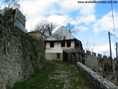
RESIDENTIAL AREA WITHIN THE RAMPARTS
This is the area of the highest townscape value, with the most valuable buildings constituting the chief characteristics of the urban centre of Jajce. This group includes the south-east slope to School street and Hrvoje Vukčić Hrvatinić street, the complex behind St Mary's church and St Luke's belltower, part of the inner side of the north perimeter ramparts and the group of streets outside Banja Luka gatehouse, as well as an isolated complex outside Travnik gatehouse and above the waterfall. This zone contains all that is most valuable and which, if all the necessary steps are taken, will guarantee the preservation of the entire composition. In this zone, the subjects of protection must include both streets and buildings, with the removal or recomposition of those that have already been built but which are detrimental to the town ramparts and out of harmony with the surroundings.
AREA OF VAROŠ
This is an area of considerable townscape value with individual buildings of high architectural quality, the natural extension of Jajce beyond the ramparts and its link with water and the adjacent slope. In this zone buildings were erected to the same scale as those within the ramparts. Roads, proportions, the physiognomy of the composition and the details that can be seen on individual buildings also follow the same rules as are found within the town.
AREA OF NATURAL HERITAGE
The entire region of Jajce is rich in natural heritage that cannot be viewed in isolation from the built heritage. In Jajce, these two components are intimately intermingled.
The appearance of tufa and tufa deposits in parts of the courses of the rivers Vrbas and Pliva has a particular part in this. Besides forming part of a coherent composition, this zone also has its own major value as a natural rarity.
TUFA AREA OF VAROŠNICA
This is at the entrance to the town of Jajce from Donji Vakuf. The area is a very significant part of the entire tufa area of Jajce, and very important for geological, geomorphological and biological research. There was once a Muslim burial ground here, which has been partly exhumed and partly abandoned and has thus disappeared completedly.
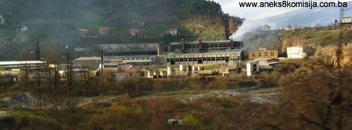
The site is directly endangered by the operations of the Elektrobosna factory by being exposed to a high level of air pollution.
RIVER PLIVA AND WATERFALL
The river Pliva is characteriyed by the specific geological nature of the terrain and distinctive morphological and hydrological features. The bed of the river, from its confluence with the Vrbas to below the village of Jezero, consists of tufa. In this area the river has created its own Veliko (large), Malo (small) and Okruglo (round) lakes with low cascades and tufa barriers. The Pliva lakes lie to the north west of the town centre, about 6 km away. The geological development of the lakes has passed through all the stages of evolution so that they have the character of tectonic, lacustrine and fluvial stages. The lakes are an important subject for the protection of nature. Research to date has ascertained that the Pliva lakes and their surroundings, primarily the sources of the rivers Pliva and Janje, the waterfall at Bukva and Sokolina, the lakes of Dragnić and Oličkin, the gorge in Janje with its rich ornithofauna, the caves by the Pliva lakes, and the mills, cascades, and natural landscape of forests and meadows with their rare flora and fauna, constitute an outstanding natural entity.
Tufa is created by special organisms known as tufa generators, and the water in which tufa is created must meet certain conditions(11). There is a great expanse of tufa, and much of the town of Jajce is built on it(12). The generation of tufa formerly outstripped the process of erosion, as can be observed on the upper strata of tufa, the top of which reaches a considerable height(13). In the 1960s the process gained momentum, as evidence by measurements taken in 1952 and 1957. Over a period of seven years, the level of the river sank by five metres. The same process is occurring at the top of the waterfall.
The waterfall is an integral part of the entire tufa area, and is on the southern side of the town, very close to the confluence of the river Pliva with the Vrbas. This natural feature is 20 m in height. Various historical factors have led to its collapsing, most recently in 2000. This is related to failure to clean the water, regulate the water flow, interventions to the river Pliva upstream from the falls, and the previous uncontrolled exploitation of tufa.
The Pliva formerly flowed directly into the Vrbas, as can be seen from old photographs of the town of Jajce. In 1947 part of the waterfall collapsed over a length of 30 metres, as a result of the high erosion potential of the material of the ground over which the river Pliva flows. In this case, unfavourable hydrological conditions led to the degradation of the tufa, with material being swept away and a high degree of erosion in the river bed and the area of the waterfall.
The current position of the waterfall is the outcome of successive incidents of collapse and regressive erosion.
In order to determine the causes of this process, the conditions that are required for the tufa generators to create tufa and the principle of depositing tufa must be known(14). The ecological conditions needed by the tufa generators, which Dr Pavletić calls bryophytes(15), are:
Ÿ the required light levels, ideally 100%
Ÿ water temperature from 10.3 to 23.4o C
Ÿ water speed from 0.5 to 3.4 m/sec, and
Ÿ hydrochemical composition of the water: alkalinity from 3.6 to 2.7, i.e. an abundance of carbonates; water hardness from 10.2 to 7.6 deg, a quantity of free CO2 and a pH value of 7.1 to 7.5
As noted, the erosion of the tufa began long ago, with the cause a long-lasting geomorphological process contingent on changes to the hydrological characteristics of the river. At first the process was somewhat slower, with the tufa generators to some extent compensating for the erosion of the tufa. It may also be assumed that over a long period some of the conditions, such as temperature, chemical composition and water quantity, would have altered.
The causes of increased erosion can be explained as follows:
a) changes to the regime of the Pliva river downstream from Veliko jezero following the construction of the hydroelectricity generating station with gravitational intervention on Veliko jezero in 1895, when as a result of this intervention low water, when the regeneration of the tufa would have been possible, no longer flowed, while mid-level and high water continued to exert constant erosion.
b) inexpert repairs to the waterfall and reinforcement of the banks are another cause of erosion(16)
c) with disastrously high flood waters in 1932, there was extensive erosion. In a single night the river bed cut into the tufa by about 2.0 m(17)
d) other interventions to the river bed, such as re-routing water back to the mills, part regulation, the extraction of tufa as building material, etc., also contributed to further erosion.
The main cause of erosion is thus major variations in water quantity leaving large areas of the river bed without water over a long period(18).
In 1995 and 1996 there was another surge of high water, and the banks of the river Pliva and some of the ledges of the river were again destroyed. The surge also caused some landslips, damaged some roads, and caused serious damage to the waterfall.
The right-hand ledge of the waterfall was completely destroyed by this surge of flood water, and there was a rockslide on the right-hand flank. Project documentation has been drawn up to make good this damage, but the work has been postponed because of financial difficulties. The state of the river bed and waterfall is such as to require urgent and major repairs. Damage to the waterfall has been caused by unfavourable hydrological conditions (long-lasting heavy rainfall), which have led to a surplus of water in the reservoir of the Pliva lakes and inability to control it. The flood surges that occurred in January/February and September 1996 resulted in the undermining and destruction of various structures previously erefect to regulate the flow of the river Pliva. The increased flow of water led to the river bed being considerably deepened, and to the undermining and part destruction of the river embankments and the banks along the entire course of the Pliva from Okruglo jezero to its confluence with the Vrbas.
On the site of the waterfall, the flow led to instability and a major landslide on the right flank of the waterfall. Very soon after this damage arose, a cavern appeared in front of the river bed below the part of the waterfall that had fallen in. The water falling from above fell through the cavern and emerged, at about half the height of the waterfall, as a wide spouting stream. This state of affairs threatened to cause continued erosion and serious localized damage, and indeed the general stability was at risk. As a result, work began on a project of interventionary repair and securing the falls (June 1996), soon followed by the works themselves (August/September 1997). The following works were carried out:
The works on the left-hand side of the falls (ledges 1 and 2) consisted of reinforcing the underlying ground, carrying out surface drainage, and installing a foundation slab and protective walls on the site of the falls. These interventions ensured the stability of the left-hand section of the waterfall until such time as the entire area is made good and the possibility of ledge 1 collapsing is reduced to a minimum. The effects of such a collapse would have a direct impact on the stability of the mass of the left bank. Since this mass is already undercut in the region of the Vrbas river bed, the collapse of any sizeable mass would put the entire surrounding area at risk.
A gabion wall was introduced to divert the water to the left-hand part of the falls (ledges 1 and 2), which is now in use. Intermittent water surges have caused damage to the gabion wall. The constant overflow of water on the damaged section of the falls (right-hand section – ledge 3) has led to serious erosion and the steady reduction in stability of the existing ledge, which is at risk in the event of any major overflow. A particularly serious problem is that of landslides (rockslides) on the right flank of the waterfall. The consequences of any further landslides are unpredictable, but it is quite certain that the present panorama building at a height of approx. 377.00 m above water level would collapse, and probably too the road beside it.
The area requiring repair consists of the waterfall itself, the river bed and the banks in the immediate vicinity. The form of the new dam has been carried out to ensure that when the flow is at a minimum the water is equally distributed to the right and left hand sides of the waterfall. In the selection of elements for individual interrventions, consideration was giving to achieving the following outcomes:
Ÿ achieving a satisfactory degree of safety for the waterfall area for the projected flow of 118 m3/sec
Ÿ maximum possible adjustment of the existing circumstances to the location to reduce the extent of works required
Ÿ adapting the visible elements of the repair works to the environs to retain the characteristics of the landscape
Ÿ encouraging maximum development of tufa
Ÿ acceptable maintenance costs
Ÿ a higher degree of protection for the land along the banks from high water overflow
From the geotechnical and hydraulic perspective, the repair works should achieve the following outcomes:
Ÿ preventing surface erosion of materials in the bed of the river Pliva in the area of the waterfall
Ÿ shaping overflow ledge 3 so that the water, at the projected volume of flow, does not pose a threat to the stability of the immediate and wider area of the falls
Ÿ to fill in the known and suspected caverns in the ground and generally improve the mechanical characteristics of the degraded and detached tufa (tufa dust and sand) by reinforcing the foundation ground (micro-pilots)
Ÿ prevent landslips, rockslides or major instability and reduce the possibility of future landslips to the scale of local instability of minor importance by directing the reinforced foundation ground
Ÿ repair favoured breaches of water and caverns on the vertical surface of the falls so as to prevent the creation of hydrostatic pressures on the repaired surfaces
Ÿ compensate possible reduction of porous ground materials in the area of the falls by a drainage system to enable drainage of the rear of the ledges of the waterfall, which will enhance the safety factor against landslips
Ÿ achieve the required minimum safety factor against landslips by anchoring the ledges in the river bed.
ANALYSIS AND STUDY OF THE SITUATION IN 1970
Before the ravages of the recent war, according to a study by architect Radoslav Jadrić in 1970, the historic centre of Jajce had a total of 870 buildings with 1,136 inhabitants. That year, with the aim of conducting a complex analysis of the current situation, each building was surveyed separately. The result was a document of lasting value, and this methodological approach should be an integral part of every revitalization study.
a) Study and valorization of existing spatial values and individual buildings:
The current situation in Jajce is differentiated into six basic categories based on chronological stylistic affiliation and used as the basis for valorization as monuments:
1. Jajce houses or Jajce architecture, or buildings erected during the Ottoman period – a category of larger residential buildings of the extended family type. The layout of these buildings is wholly oriental, with a typical arrangement of rooms and occupancy on the ground and first floor. The interiors of such buildings are usually of wood with wood carving. Most were built in the 17th and 18th century, but later 19th century buildings also have the same features. The proportions and facade surfaces reveal a mature architectural achievement. These buildings, together with archaeological remains and buildings of monumental and public Ottoman architecture, are of the nature of monuments. The total number of such buildings is very modest, a mere 8%.
2. varoš architecture – the local interpretation of the oriental house. These were built mainly in the 19th century. The buildings have an upper floor, but are of rather smaller dimensions than their oriental models. The layout of the buildings is free, simplified and without special qualities. The formal elements of the exterior are retained in somewhat simpler form. The buildings are clearly differentiated vertically between the stone ground floor, whitewashed post-and-pan upper floor and high hipped roof, and the rhythm and proportions of the windows are those of oriental architecture. The exterior formal elements and position in the terrain give this group significant architectural and townscape value. This is the most numerous group and constitutes 45% of the total
3. contemporary varoš architecture – the product of local interpretation of the tradition and the influence of Austria-Hungary. These are smallish two storey buildings also typified by vertical differentiation into ground floor, upper floor and roof. In this case, the ground floor and upper floor have lost their oriental character. The roof has become gabled, often with cross-gables or roof bird wing with a single room in the roof space. The roof pitch is shallower, and tiles are used to clad the roof. Alterations to buildings of varoš architecture usually result in their acquiring the features of this category. This type of house gradually began to encroach from the earliest years of the Austro-Hungarian occupation of Bosnia and Herzegovina. Thanks to their placing in the terrain, proportions and unobtrusive dimensions, these buildings have also acquired a degree of townscape value in the urban zones of Varoš and Kozluk. They constitute 18% of the urban fabric.
4. Austro-Hungarian buildings and buildings dating from between the two wars, which as noted earlier have features of eclectic architecture. These buildings account for 15% of the total.
5. New buildings, the category of buildings erected since World War II. Buildings not erected privately are typified by radical changes to historical proportions and dimensions. Most of them clash with the environment. This group is numerically small: 7%.
6. Buildings that belong to no particular style or that have been so altered as to lose all their stylistic features constitute a small group of 8% of the total
b) analysis and study of physical conditions and use – current situation
1. by number of storeys:
Ÿ small single storey buildings 2,5 %
Ÿ single storey buildings 14 %
Ÿ buildings with one upper floor 74 %
Ÿ buildings with two upper floors 8,5 %
Ÿ buildings with three or more upper floors 1 %
2. analysis of building materials:
Ÿ stone ground floor and post-and-pan upper floor 65 %
Ÿ brick and tufa with timber floor/ceiling joists 14 %
Ÿ solid reinforced concrete buildings 4,5 %
Ÿ other buildings 2,5 %
3.type of roof:
Ÿ original Bosnian roof 38 %
Ÿ gabled modernized roof 31 %
Ÿ roof with bird wings 8 %
Ÿ other 23 %
4.type of roof cladding:
Ÿ shingles, sheet metal 38 %
Ÿ tiles 56 %
Ÿ other 6 %
5.overview of alterations to buildings:
Ÿ unchanged 37 %
Ÿ complete transformation 17 %
Ÿ alteration to roof type and cladding 22 %
Ÿ altered layout and facade 24 %
By analyzing the current situation, it was ascertained that the majority of buildings are exposed to deterioration and dilapidation, are poorly equipped and, generally speaking, the majority of buildings in the historic zone had very poor housing standards. The reasons for this were identified as:
1. the materials used to build the houses rapidly deteriorate if not regularly maintained
2. there is a tendency on the part of the population strata that are somewhat better situated financially to abandon the historic zone. Before the 1992-95 war the number of people living there was only 40% of the late 19th century figure.
3. steep-pitched roofs were at greatest risk although not directly related to interventions to improve living conditions
4. lack of awareness of the need to preserve the heritage.
INDIVIDUAL BUILDINGS
In Jajce and its surroundings, cultural monuments have been categorized or recorded from the antique era (Roman settlement, Roman fortifications, a Roman temple and late antique tomb); from the mediaeval period (tombstones, necropolises, the tower and church of St Luke, Vinac fort, Jajce fort [prehistoric, Roman, late antique settlement, mediaeval fort], Jezero fort, Komotin fort); from the Ottoman period (religious buildings: the Čaršija (Esma Sultana) mosque, the Sinan beg or Okić mosque, the Šamić or Hajji Muharem mosque, the Dizdar mosque, the Ibrahim beg mosque, the Roman Catholic church in Varoš, the Kršlak house, the musafirhana and tekke of the Mulalić family, the Tufik han, česma drinking fountains, the šadrvan fountain by the Esma Sultana mosque, turbes, burial grounds); and the Austro-Hungarian period (the Hadadan mosque, the new church of St John the Baptist in Podmilačje, the Bosnian electricity joint stock company villa).
PREHISTORIC PERIOD:
The oldest known settlement of Jajce dates from the Middle Bronze age, about 1500 BCE. The oldest settlement is on the site of the present-day fortress, and ample traces have also been found on the former Brotherhood and Unity Square. Judging from the remains found to date, the settlement was abandoned before the end of the Bronze age, about 1000 BCE (Basler, Đuro, 1965, p. 1).
Traces of habitation from the prehistoric era were also found in the tufa caves along the banks of the Pliva at the end of the 19th century by Dr Truhelka, archaeologist and historian (Jadrić, R. 1970).
ROMAN PERIOD
The Roman settlement probably stood on the same site, with a fortress on the summit of the hill and houses below.
The remains of a Roman brickfield of unknown capacity have been found on the right bank of the Pliva(19), and on the other side of the town, outside the town ramparts to the north of Banja Luka gatehouse, the remains of a necropolis were found. On the western edge of the town, also outside the mediaeval ramparts, is the temple of the god Mithras, dating from the 4th century CE.
MITHRAEUM
The temple to Mithras in Jajce is located on a site known as Bare. More detailed information on the monument may be found in Decision no. 06-6-743/03 dated 21 January 2003 by which the historic monument of the Mithraeum in Jajce is protected as a national monument.
MEDIAEVAL PERIOD:
ST. MARY’S CHURCH with ST. LUKE’S BELLTOWER
The monument of St. Mary’s Church with St. Luke’s Belltower is located within the historical nucleus of Jajce, at the foot of the citadel.
The building underwent several stages of construction. Given the complexity and date of the buildings, and the number of times they were subjected to alterations and demolition over the centuries, it is impossible to determine with any certainty their original appearance. The assumption is that the original building was a simple single-nave basilica of Romanesque style – a simple oratory with a wide nave and rectangular extension for the choir (sanctuary) where the altar stood against the wall.
The church was turned into a mosque in the early sixteenth century. It remained in use until the fire of 1832.
More detailed information on the monument may be found in Decision no. 07-6-1/03-1 dated 21 January 2003 by which the architectural ensemble of St Mary's church with St Luke's belltower in Jajce is protected as a national monument.
CATACOMBS
The catacombs are hollowed out into the living rock within the town ramparts, below the plateau between the Medvjed tower and the church of St Mary with St Luke's belltower, in an ensemble where several religious buildings (a church, a Franciscan monastery and a graveyard) have been erected over the centuries.
The historic monument is an underground structure, and is basically arranged similarly to a church, with a narthex, baptistery with fonts, nave, presbytery with altar space. The catacombs are oriented south-north, with the entrance at the south end.
More detailed information on the monument may be found in Decision no. 06-6-742/03 dated 21January 2003 by which the historic monument of the Catacombs in Jajce is protected as a national monument.
JAJCE FORTRESS
The fortress stands on the north-west corner of the urban area on the summit of the hill, at an altitude of 470 m above seal level. Different experts have different views on the date of construction of the fortress, but all agree that it certainly predates Hrvoje’s rule. Some date it to the 13th century (Mazalić, 1952, 100; in part Basler 1959, 130; Ančić, 1999, 98), and others to as late as the mid 14th century (M. Popović 1997, 22-23).
The fortress has the shape of an irregular square, the result of the configuration of the terrain. At the north-western and south-eastern corners stand two strong four-sided towers, and there seems to have originally been another tower in the south-eastern corner. The perimeter of the fortress is 260 m, and its surface area 4800 sq.m.
More detailed information may be found in Decision no. 06-6-504/03-1 dated 21 January 2003, by which the architectural ensemble of the fortress in Jajce is protected as a national monument.
CLOCK TOWER
The Clock Tower is in the upper town, in Gornja Mahala.
The tower was built in the mediaeval period as a tower projecting outside the fortress. The assumption is that it was built at the same time as the bailey, during the rule of Hrvoje Vukčiće Hrvatinić. The tower has retained in full the character of a mediaeval entrance tower leading to the area outside the fortifications, as is plain to see from the old Jajce residential conglomeration as well as from the nature and position of the tower itself.
The name clock tower is unsuitable for the building, given that there is absolutely no official data on the clock that might once have stood there, nor was the tower built for that purpose. Basler, too, says that there is no evidence that there ever was a clock there (Basler, Prijedlog za konzervaciju-vlasništvo općine Jajce), although according to one Hadžo Šećerćehajić the building really was turned into a clock tower during the Ottoman period and the clock was fixed above the gate, on the arch on the east side. The family Šeherćehajić, whose house was nearby, looked after the clock. After the occupation of Bosnia and Herzegovina, Austro-Hungarian soldiers took away the clock and bell (Dr. Ćurić, Hajrudin , 1972).
The clock tower in Jajce is a typical fortifications building, with a ground plan of an irregular rectangle measuring 10.50 x 9.00 metres. The walls are of quarry stone, as much as 3.50 m. thick in places. Hydraulic lime mortar was used for bonding. The building is entirely roofed over with a steep hipped roof clad with wooden shingles. It has two arch-vaulted doors, one to the east and one to the west, through which one enters the high central area. Interventions dating from various periods are visible on the wall surfaces.
NORTHERN PERIMETER RAMPART
This runs from the north-east corner to Šamić bastion, a distance of about 290 m, and traces of the mediaeval wall extended right down to the right bank of the old bed of the river Pliva.
1. From the north-east corner of the fortress to Mračna gatehouse-Velike tabija:
This part of the wall is 50 long and up to 11 m high, and consists of two walls. In the mediaeval period a thin wall, 0.80 m thick, reducing to 0.74 m at the top, was built of mudstone and quarry stone bonded with a mortar composed of lime, tufa dust and broken brick.
The later reinforcements to the wall on the inner side are 1.6m thick, and built of mudstone and lime mortar with a high proportion of coarse sand and gravel. The entire wall is 2.4 thick. Part of the parapet has survived, leading to the assumption that the entire length of the wall was topped with parapets. Towards the east and Mračna gatehouse it increases in thickness to 3.5 m. Prior to conservation it had collapsed to such an extent that it was only from its steepness that one could hypothesize that the top of the built-on inner section was reached by stone steps. Close to Mračna gatehouse the exterior face of part of the wall fell off at some unknown date. It was rebuilt with rectangular stones laid in various ways, probably in the late Ottoman period. When the wall was built onto in the Ottoman period, loopholes were also built (Basler, 1967, 51). During later interventions, the stone steps and walkway were made good and part of the breastwork walls were erected.
2. Mračna gatehouse
The site of this gatehouse – the passage between Velika tabija and the wall described above – is now empty. It had a semicircular vault and «some sculptural signs» on the side. All that remained of it was three semicircular niches on the inner revetment of Velika tabija, which had adorned the inside of the gatehouse. Originally, the niches had pointed arches.
Nothing can be said of its age, but the assumption is that it was built during the general reconstruction of the late 18th or early 19th century, which could not have taken place before 1717, the date of a report by an Austrian spy. Typical of the buildings of that time was regular courses of dressed stone and the use of lime mortar with a high proportion of coarse river gravel from the Vrbas.
3. Velika tabija
Velika tabija or large bastion is assumed to have been built on the site of a square mediaeval tower, traces of which can be seen in the embankment of the bastion. It was probably built during the period of great wars when works on the reorganization of the fortress were carried out in the late 18th or early 19th century. In position and size it was a particularly imposing building.
Before the conservation works carried out between 1960 and 1966 the surrounding wall of the bastion had been rebuilt, having almost completely collapsed. Much of the north wall had been prized away. The inner walls were also in poor condition.
During conservation works, steps were built to allow access to the basion (Basler, 1967, 52).
4. Wall from Velika tabija to the tower at Džikovac
This wall was 73 m long and 4-5 m high. The older, mediaeval wall was 0.9 m thick and built of quarry stone randomly laid. Against it, on the inside, a wall was built on in a manner similar to that on Velika tabija, making the present thickness of the walls 2.3 m. Prior to conservation the wall was barely visible. The wall is identical in every way with the wall above Mračna gatehouse, and also probably had a parapet, and was probably reached, between the mediaeval period and the great reconstruction, by a wooden terrace, and later from the inside by the wall that was built on the inside (Basler, 196, 53).
5. Tower at Džikovac
In shape this was more a bastion than a tower, a later addition built into the wall during the Ottoman period. It was squarish in section (sides 8-10 m long), and banked up with earth. It could not be very large owing to the restricted space. It was built during the 17th to 18th century. Alongside it to the east part of the wall had four breastworks built on.
This built-on section of wall is of the same date as the tower, and the stone in this wall is dressed in the same way as in the retaining walls dated to the 17th century on the south wall (Basler, 1967, 53).
6.Wall between the tower at Džikovac and the Papaz tower
This is the part of the wall that remains most intact and and is the best preserved original part of the mediaeval fortifications of the Jajce civilian settlement. The original mediaeval breastworks have survived here – four of them above the Papaz gatehouse. Between the breastworks were metal covers attached to small consoles on the outer side of the breastworks. These breastworks are of the type known as minor breastworks, unlike those on the south wall of the fortress and the wall by the Banja Luka gatehouse. They were built of tufa, and each has an arrowslit. In the Ottoman period they were plastered over by way of maintenance. Like part of the wall from Papaz gatehouse to Šamić bastion, the wall is very solidly built of regular courses of stone over the full width of almost 4 m. This was the area most at risk from direct attack, and thus requiring the most effective defences. Part of the wall is mediaeval, with another part built on in the 17th to 18th century, making the overall thickness of the wall 2.70 m. There is access to the wall only by Papaz gatehouse, but the assumption is that when the tower at Džikovac was added, the walkway along the entire wall was interrupted (Basler, 1967, 54).
During conservation works the crown of the wall was given a new coping.
7. Papaz Tower
This tower is alongside the Banja Luka gatehouse, and was a typical mediaeval structure, later twice rebuilt. Despite this, much of the existing walls of the original building have survived. The tower had a very prominent defence position, so that more care was taken over its reinforcements and maintenance than with some of the other towers. It was probably in the Ottoman period that reinforcements were added on the inside of the tower. In the 17th century the two corners of the tower on the town side were patched up. The tower is roughly square, with the sides measuring 19.95 x 10.58 m. The walls are of quarry stone, ranging in thickness from 2.40 m on the south to 5.25 m on the north. The tower was entered from the south through an arch vaulted gate. Inside the tower was a roughly square room measuring 4.65 x 4.33 m.
The tower was formerly 5-6 m higher than now, and its walls were 1-2 m higher than the breastwork on the adjoining wall. The interior construction and roof of the tower were of timber. There are signs of fire on the walls (Basler, 1967, 54).
Inside the Papaz tower the stone facing can be seen to have fallen away on the upper third of the wall.
8. Banja Luka (Papaz) Gatehouse
The Banja Luka gatehouse guarded the northern entrance to the town of Jajce.
The building consists of a tower and gate – the northern entrance to the town. Outside the gatehouse there was formerly a dry fosse. The walls of the gatehouse are 4.55 m thick. The gatehouse gradually widens from north to south, with a width of 3.21 m to the north and 5.5 m to the south. The height of the entrance to the north is 4.55 m and to the south 5.35 m. The gate no longer has its original exterior door frame, which was once narrower and fitted with hingers for a metal gate. The gate could be closed with a solid portcullis lowered by a lever. The opening for the lever was between the second and third parapet and is still visible today. The doors with their iron fittings still stood until 1906, when the gate was widened to allow for the passage of wider vehicles. There is a decorative carving of a warrior on the outside of the north doorjamb, which was added in the Ottoman period, as was the custom at that time. The breastworks have been reconstructed on the crown of the wall above the gate, on the basis of a surviving drawing made in 1890 and the remaining foundations of two breastworks. The walls with parapets and loopholes around the Banja Luka gatehouse, in substructure at least, and the tower by the gate are partly built in a manner similar to the Medvjed tower, with vertically laid stone on the revetments (Anđelić, 1963, 50-52; Basler, 1967, 54).
9. Wall between Banja Luka gatehouse (Papaz gatehouse) and Šamić bastion
Much of this wall is of mediaeval origin, when the breastworks were built. Until the 1890s, the ruins of the breastworks survived, particularly in the section close to Papaz gatehouse. They were somewhat larger than those on the wall above the gate. Large sections of the wall were rebuilt during rebuilding and repairs between the 17th and 19th centuries, and these reinforcements to the wall have resulted in its being 4.7 m thick. On the outer face of the wall, facing Varoš, there are abundant traces of repairs and patching up.
On the inner side, the face of the wall is quite badly damaged, more because the locals dismantling the wall and taking the stone away. The foundations of the wall are of large stone blocks randomly laid. The interior mass of the wall is very solid, made of quarry stone laid in layers and bonded with slaked lime, without tie beams. This type of masonry is more solid than revetting the outer walls andn filling with a mixture of mortar and stone. During conservation and restoration works, the walkway was paved, and stone steps were made on the steep sections of the walls. On the exterior, a row of breastworks were built, restoring the appearance of the old building, while on the inside a parapet wall was built (Basler, 1967, 54).
10. Šamić bastion
This bastion was a stronghold of major value. It projects far out from the wall to allow for the positioning of the cannons that protected the Papaz gatehouse. The foundations of the bastion are therefore dug deep into the soil that forms part of the bank of the Vrbas. The polygonal bastion was created by building on to a mediaeval square tower in the late 18th or early 19th century. The mediaeval structure was built at the same time as the adjoining wall, and part of the vertical wall can still be seen where the front of the bastion meets the great wall to the north. In the middle of the east wall, north to south, is a large arch made of four courses of cut stone, like some huge portal.
During conservation and restoration works, stone steps were placed on the steep sections of the walls from this bastion to above Banja Luka gatehouse (Basler, 1967, 54).
10. Wall between the Vrbas and Šamić bastion
This section of the ramparts lies on the base of a mediaeval wall. Here Mazalić found a retaining wall 8-10 m high, and at the angle the wall forms with the Vrbas he found traces of a guardroom with the remains of a round-arched aperture in the breastworks. This very dilapidated section of the ramparts probably dates from the 17th to 18th century (Mazalić, 1952, 74; Basler, 1967, 55).
WESTERN PERIMETER RAMPART
This rampart was built in the mediaeval period, probably around the mid 15th century, when the Bosnian kings showed increased concern for the fortifications of teh town. It runs from the south western corner of the fortress to the bank of the old bed of the Pliva, a distance of about 200 m. Apart from the Medvjed tower and two «knee-joints», one at the level of the clock tower, resulting from adaptations to firewarms, it has no other defence features.
1. Wall from the fortress to Medvjed tower
The wall running from the fortress to Medvjed tower, with an average thickness of 0.6 to 0.9 m, is in a poor state of preservation. It seems never to have been a particularly solid structure. The upper part of the wall has retained all the features of mediaeval construction. Level with the clock tower the wall curves. It is currently completely overgrown with self-sown vegetation.
2. Medjved tower
The Medvjed tower is very close to the Catacombs and to St Mary's church and St Luke's belltower, on c.p. no. 1002, c.m. Jajce I.
The tower was probably built in the mid 15th century, during the last decade and a half of Bosnia's independence (1448-1463), during which the last Bosnian kings engaged in much building. This is suggested by the increased thickness of the walls, regular horizontal lines in the revetment, and the shape of the Medvjed tower.
The tower belongs to the type of massive, round defensive tower that began to be built with the introduction of firearms. The tower is in fact the only reinforcement on the western perimeter rampart, as potentially the last refuge of the defending forces; it could be defended alone, and also guarded the approach to the town from the west. From the top of the tower one could observe enemy movements from that direction. It was thus built and positioned so that the enemy could not hold position either close by or further away from the town, leaving the area free for communication with the defenders of the town.
The tower is of more recent date than the western perimeter ramparts. The walls range in thickness from 4.70 m. on the east to 6.0 m. on the west side of the tower. The inside radius at ground floor level is 5.70 m., and on the upper floor 8.14 m. Mortar consisting of a small proportion of lime and a great deal of tufa dust was used in the construction. The south wall is vertical on the exterior, while the north wall has a slight inclination towards the interior. In addition to the entrance, located 8.50 m. above ground level, there were three openings on the first floor level of the two, two of which served as loopholes. A square window on the tower was made in the late Gothic style.
There are some places on the revetment of the Medvjed tower where the way the revetment is laid is very striking: stone blocks in the form of parallelopipedes are often laid upright in the revetment. Over the centuries these vertical blocks became rounded (the rain flowed more easily along the grooves and ate away the stone). These vertical blocks are of sedimentary limestone taken from the rocky prominence on which Jajce stands. There is no tufa. The stone is roughly dressed, without the use of more sophisticated stonemasons’ tools, came from a single workshop, and was laid in a single stage of construction. The same construction is to be seen in the north wall around the Banja Luka gatehouse, in the substructure of the gatehouse itself (Anđelić, 1963, 51).
In about 1890 an entrance was pierced and steps built alongside the tower. During World War II an entrance was pierced into the ground floor of the tower.
3. Wall south of Medvjed tower to the Pliva
Two thirds of the wall south of Medvjed tower is of old mediaeval construction. This part of the wall contains a secret passage, forming an integral part of the fortifications with the Medvjed tower. The last third of the wall, to the bank of the Pliva, was built in the Ottoman period, 17 to 18th century. The wall has a polygonal extrusion at the end making it into a bastion. The entire outside of the wall surface is overgrown with self-sown vegetation.
EAST PERIMETER WALLS (ALONG LEFT BANK OF VRBAS) AND SOUTH (ALONG LEFT BANK OF PLIVA)
The left bank of the Vrbas, down to the waterfall, is a vertical cliff of dripstone. Here and there, where there were no natural barriers, the bank has been reinforced by embankments as far as the waterfall.
The terrain along the old bed by the left bank of the Pliva, on both sides of the Travnik gatehouse, is secured partly by the naturally fortified terrain. A strong wall was probably erected in mediaeval times on the site of the tower above the Travnik gatehouse, through which the ancient road ran.
1. Travnik gatehouse
The Travnik gatehouse is the south entrance to the old town of Jajce. It is also known as the Pliva, Lower and South gatehouse.
When Jajce came under Ottoman imperial rule, it lost the strategic importance it had enjoyed for so long only after the defeat at Vienna and then at Senta. A high tower was then built, square in section, and typical in form of Ottoman gatehouses of the late 17th and early 18th century. A small bastion was erected beside it. This is the only tower in the Jajce fortifications to have a stone-vaulted ground floor. To judge from its form, it was built in the late 17th or early 18th century. At little higher up than this gatehouse, a solid bridge over the Pliva was built in the 16th century. The bridge was always kept well maintained, because of its importance for troop movements from Travnik in central Bosnia (Đ. Mazalić, 1952, 76). The terrain outside both the Banja Luka and the Travnik gatehouses was probably protected by wide, deep fosses with drawbridges.
The Travnik gate is rectangular in section, measuring 8.75 x 9.10 m. It is built of quarry stone, with the thickness of the walls at ground floor level 3.30 m on the exterior or south side and 1.45 m on the interior or north side. The thickness of the walls of the upper storeys is about 1.20 m. There was one first floor room entered from the west, from the ramparts area, nowadays from the courtyard of the Omerbeg house. This room measured 6.82 x 5.93 m, and probably housed the guard. To the south, north and east it had loopholes. A wooden staircase led from this room to the second storey of the tower, where there was yet another room of similar size and shape as the first floor room, but with only two windows facing inwards, on the north side. The floor joists were timber.
OTTOMAN PERIOD
During the Ottoman period, urban features gradually arose on the site of the mediaeval market and settlement, their structure shaped throughout history. The urban layout of the Ottoman town was based on the principle of numerous groups of houses of mahalas linked spatially. In Jajce, unlike in Sarajevo where residential neighbourhoods were created from scratch, these neighbourhoods arose on the site of the mediaeval settlement outside the ramparts. Each neighbourhood would have about thirty houses, and public facilities: a bakery, mekteb, mosque and school. Other public facilities were located in the čaršija, which grew up on the site of the mediaeval market. The principle of strict separation between the residential and commercial quarters of town were strictly applied here, too.
RELIGIOUS BUILDINGS
MOSQUES
According to the census of real vakuf property, there were six mosques in Jajce: the Hajji Muharem mosque in Čarši mahala, the street between the Travnik and the Banja Luka gatehouses, Ramadan beg mosque in Pliva mahala – Pijavice, the Esma Sultana mosque in Čarši mahala, the Hadadan mosque in Prigrađu(20), the Dizdar's mosque and the Sinan beg mosque in Gornja Mahala(21). Until the 1992-95 war, four of these were still in existence: the two in Čarši mahala, one in Pijavice and one in the upper part of town, the Sinan beg or Okić mosque(22). A Jajce sidžil from the late 17th century refers to four mosques in Jajce(23).Only the Čaršija (Esma Sultana) mosque was domed.
ČARŠIJA (ESMA SULTANA) MOSQUE
The Esma Sultana mosque stands in the centre of the Jajce čaršija or old crafts and commercial centre, in the main street linking the Travnik and the Banja Luka gatehouses.
The chronogram over the portal recounts that the mosque was built in 1749/50, and that its founder was the čauški ćehaja or senior military officer Emir Mustafa. The chronogram also indicates that there had been an earlier mosque on the site, that of Mir Mustafa Čehaja (Mujezinović, 1998, p. 261).
It belonged to the type of mosque with a central dome with roofed sofas (porches) and a stone-built minaret.
The dome was set over a roughly square ground plan of 9.49 x 9.55 m (interior dimensions). The dome was elongated, departing from the regular hemispherical outline, in which it differed from other larger domed mosques.
The Sultana Esma mosque was the finest of Jajce’s mosques of the Ottoman period. In the opinion of M. Mujezinović this mosque was one of the last domed mosques to be built in Bosnia and Herzegovina.
Within the mosque premises there was a fountain, a mekteb (Muslim religious school) and graveyard.
The Sultana Esma Mosque was completely destroyed in 1993. Works are currently under way to rehabilitate the building.
More detailed information may be found in Decision no. 08.2-6-4/03-4 dated 21 January 2003 by which the site and remains of the architectural ensemblde of the Esma Sultana mosque in Jajce is protected as a national monument.
SINAN BEG MOSQUE
The Sinan-beg or Okić mosque is located in Gornja Mahala.
According to unverified information, the mosque was built around 1689 as an endowment of Sinan-beg Džabić.
It belongs to the type with a single central space, and originally had no wooden balconies (so called sofa). The entire space is roofed by an ellipsoidal dome made of limestone, which is concealed by a tent-shaped hipped roof. The mosque had an octagonal wooden minaret.
The mosque did not differ essentially in appearance from the surrounding residential buildings in Gornja Mahala.
There is a water fountain in the south wall of the mosque, with an inscription.
The Sinan-beg mosque was damaged during the war in BiH, in 1993, when all its wooden components burned down – the minaret and the roof structure. The mosque has been rehabilitated.
More detailed information can be found in Decision no. 08/2-6-3/03-1 dated 21 January 2003 by which the historic building of the Sinan beg mosque in Jajce is protected as a national monument.
THE DIZDAR'S OR WOMEN'S MOSQUE
The Dizdar's or Women’s Mosque is located in the upper part of town known as Gornja Mahala, immediately beside the Jajce citadel.
The mosque was built by Sulejman-bey Kulenović in 1812/13.
The Dizdar's Mosque in Jajce belongs to the typological series of central single-space mosques without sofas and minaret, with a masonry dome concealed by a tent-like hipped roof. The whole interior space is vaulted by a stone dome on trompes. Tufa was used to build the dome and trompes.
The interior of the mosque was decorated with traditional floral motifs of garlands and leaves. The building had a steeply pitched hipped roof, like the surrounding houses, with a covering of chestnut-wood shingles. The mosque did not have a minaret.
The building was reconstructed during 2002.
More detailed information may be found in Decision no. 08.2-6-2/03-1 dated 21 January 2003 by which the historic building of the Dizdar's mosque in Jajce is protected as a national monument.
IBRAHIM BEG MOSQUE
The Ibrahimbeg or Pijavička(24) mosque in Jajce is outside the town ramparts on the right bank of the river Pliva by the Jajce-Bihać road, and comprises c.p. no. 1023, c.m. Jajce I, Federation of BiH, Bosnia and Herzegovina.
The precise date when the mosque was built is not known. According to M. Mujezinović, it must have been prior to Sha'ban 1103 AH (18 June 1692), when one Fazlulah was appointed as imam of the mosque, replacing the previous imam, Ibrahima(25). There are two tombs with epitaphs inside the mosque, in the south-west sofa; Seksen Kilič-zade Sheikh Ašik Mustafa, son of Mehmed, was buried in the first on 1 Safar 1267 AH (6 December 1850). The other has women's nišan tombstones and no date for their erection, but this is known to be the grave of Almasa, wife of Ašik Mustafa efendi.
The Ibrahim bed mosque belongs to the typological series of central single-space mosques with sofas. There is a wooden portico with sofas on the main entrance facade, with a total of 8 wooden pillars. The openings of the portico terminate in ogee arches.
The interior prayer space measures 7.00 x 8.00 metres. The mosque has walls 80 cm thick and is entirely built of tufa. It had a steep polygonal hipped roof. The original roof cladding was wooden shingles, but a later intervention replaced this with sheet metal.
The entrance portal to the mosque was arched and made of cut stone slabs. There are two graves in the right-hand sofa of the mosque portico, marked by nišan tombstones, constituting one of the major features of this mosque. On the north east facade are four rectangular windows of medium height and width (Bečirbegović, str. 122).
The windows in the lower row are rectangular, and those of the upper row are round-arched.
The mosque had an octagonal wooden minaret terminating in an alem with three pommels. Around the mosque is a small harem with a few nišan tombstones with no epitaphs.
During the war in Bosnia and Herzegovina the building suffered serious damage to the roof structure and parts of the walls. After the war the effects of the elements led to further deterioration of the structure.
ŠAMIĆ OR HAJJI MUHAREM MOSQUE
The mosque stands in the eponymous mahala beside the town ramparts by the Šamić bastion, east of the Banja Luka gatehouse, by the river Vrbas.
The precise date when it was built is not known, but the inscription over the entrance reveals that it was renovated in 1849. It is assumed to have dated originally from the early 18th century.
It is a small building with a wooden minaret, and is now in a state of neglect and somewhat altered from its authentic form(26). A surviving photograph taken before the entrance portico was built on shows what it looked like previously. The mosque had a simple wooden minaret with vertical uprights. The roof of the mosque was steep and clad in wooden shingles. The building material used to build it was stone to which a layer of lime mortar was applied. Four rectangular windows with bars could be seen on the facade. The mosque was whitewashed and could serve as an example of a well-proportioned stone mosque (Bečirbegović, p. 123). During later interventions, of which there are no details as to when they were carried out, the roof cladding of shingles was replaced by sheet metal.
The building was almost completely destroyed during the war in Bosnia and Herzegovina. Part of the walls have survived, with the tufa mihrab surviving intact.
HANS
In addition to crafts and trade, Jajce also had well developed service facilities designed to feed and accommodate the many people who passed through the town. Both in the town and in surrounding places there were many hans, particularly on the road from Travnik via Karaula to Jajce. Evliya Çelebi counted the hans and hamams in these places. The hans in the river Vrbas valley are evidence of the constant movement of people and of the trade and other links between the inhabitants of Jajce and other developed centres in Bosnia, Dalmatia and elsewhere.
In the town itself there were several such facilities. There are reference to the Mulalić han, the Šeherćehajić han, the Ribić han, the Kršlak han, the Pilavdžija, Čavar, Kožbeg, Hajji Mujo and other hans. Most hans were located between the Travnik and the Banja Luka gatehouses, with the exception of the Pilavdžija and Kožibeg hans. With the laying of the railway line, some of the hans lost their former role and disappeared as time passed, but some were still in existence just prior to World War II.
The han with the greatest architectural value was the Teufik han, built before 1850, which some say was a protected monument, though there are no official data on this. The han had wooden beds on the ground floor and several beds on the first floor, stabling, and a large courtyard where horses were tethered.
There was also a large han in the Jajce suburbs on the right bank of the Vrbas by the former ferry (skela). The whole district took its name of Han Skela from the han and ferry (Eminefendić, str. 37).
HAMAM IN JAJCE
According to Kreševljaković, there was a hamam in Jajce which was destroyed by fire 250 years ago. Among travel chroniclers, both Atanasije Georgiceo and Evliya Çelebı mention the hamam.
Georgiceo says that the hamam was created out of one of the churches, while Avliya refers to it was one of the more interesting buildings in Jajce. There is no written evidence of its origins. Atanasije Georgiceo's remarks cannot be true to the facts, because it would be impossible to turn a church into a hamam. It is possible that building materials from a church was used to build it.
Before World War I, when the Džabić beg house was being built, the remains of the stone walls of the hamam were used as building material.
During the excavation of the foundations for a house very close to the Čaršija (Esma Sultana) mosque, the remains of a small hamam were found with the layout of the various rooms preserved.
MUSAFIRHANA(27) IN JAJCE
There were several musafirhanas in Jajce providing food and accommodation, among which the Mulalić family's musafirhana survived until the war. The musafirhana was built by Hajji Jusuf Mulalić in the early 19th century, and also contained a tekke, for the maintenance of which he endowed a substantial vakuf. The musafirhana was in the main street, close to the Travnik gatehouse, about 20 metres to the south.
Both the musafirhana and the tekke were in active use until 1878. In about 1907 the ground floor part of the musafirhana was turned into a han and the rooms on the upper floor converted into residential premises.
The significance of the building lies in the fact that it is a rare example of an oriental house with two upper storeys.
The musafirhana was totally destroyed in 1992. All the fragments were removed from the site and taken to an unknown destination.
More detailed information may be found in the Decision by which the site and remains of the historic building of the Musafirhana in Jajce is protected as a national monument.
MEMORIALS, BURIAL GROUNDS AND MAUSOLEA
There are several burial grounds in the town of Jajce, which are of interest both for their size and for the types of material and workmanship of tombstones, certain ornamentation on individual tombstones, orthography and other features.
According to an inventory of real vakuf property, during the Kingdom of Yugoslavia there were 15 Muslim burial grounds, some small, some quite large. Among the largest are Varošnice, Harmani, Katin and Carevo polje, with smaller ones or harems alongside the mosques of Jajce. Some mahalas had their own burial grounds, which were then named for the mahala in question – čarši-mahalsko, donje-mahalsko and so on. Others had their own names, such as the burial grounds of Varošnice, Bostanluk, Nišani, Mezarluci, Baščeluci.
VAROŠNICA BURIAL GROUND
The oldest and finest burial ground in Jajce was Varošnice. «It is not known how old it is, but from some of the nišan tombstones it can be determined that it was in existence in the first half of the 17th century» (Đoko Mazalić, Miloš Milošević, p. 34.). This burial ground is on an elevation above the right bank of the river Pliva, occupying an area about 300 m long and wide, and was one of the largest in Bosnia and Herzegovina.
There are a large number of pits or hollows with rounded edges that look like the foundations of buildings. The burial ground had a large number of nišan, perhaps about a thousand. All of them were small in size and made of limestone; most of them were simple. They were made of both roughly and finely dressed stone. Most of the nišans had no epitaph. In particular, old epitaphs, dating from before 1878, were very few in number. The tombstones dating from later than 1878 show that members of the Kapetanović, Makić, Zjahić, Arapović, Ribić, Hrnjić, Kršlaković, Hadžiosmanović, Bubrić and other families were buried there.
Among the older tombstones, a nišan with an epitaph dating from before 1600 stands out in particular. The nišan on which the epitaph was incised is octagonal in cross section, with a square base and pyramidal top, and stands 96 cm high. The script used was simple naskh. The epitaph reads: «O God who openeth the gates (the way out of all things), open for us too the finest gates. The owner of this tomb passed on from the transient to the eternal home in the year one thousand and nine» (1591/1592).
One nišan tombstone with no epitaph or turban bore a carving of two clubs. Another typical nišan had a fez, with the tombstone set on a sarcophagus – here the year 1267 (1850/51) could be read, but the name of the deceased was damaged.
The road to Travnik ran through Varošnice until the new road was built. This road led from the Pliva bridge along the right bank of the Pliva to the waterfall and on towards Donji Vakuf.
The terrain of Varošnice is predominantly tufa, which was a very easily worked and cheap material for building houses and public edifices. There is almost no building in Jajce erected between the two World Wars or earlier that does not include tufa, which was already being extracted in and around the town in the «pre-Ottoman period».
With time the burial ground in Varošnice became eroded. After World War II it was abandoned and exhumed.
The small burial ground by the mosque in Pijavice contains a few sarcophaguses, as does Mali mezari in Harmani.
EDUCATIONAL BUILDINGS
MEKTEBS
The mekteb of Derviš-beg used to exist in Jajce, built in the early 19th century; this and the Melek Ahmet pasha mekteb referred to by Evliya Çelebi, were the only two independent mektebs in the town. According to a bujruldija of Vedžihi pasha dated 1256 AH (1840), the Jajce kapetan Derviš-beg set aside a sum of 15 groschen a day for this mekteb from the vakuf of the late Abdurrahim aga, who built the Jajce medresa(Kasumović, p. 129).
MEDRESAS
According to some sources there were several medresas in Jajce, of which the best known were the Melek Ahmed pasha medresa, built before 1664, and the Hajji Mehmed medresa, built in 1693 (Truhelka, 1918, p. 159.), along with the medresa of Jajčeli Abdurrahim aga which originated with repairs to one of these in 1743.
INFRASTRUKTURE FACILITIES
ČESME FOUNTAINS
In the old town, česma fountains occupy an important place. In 1892 a watermain was installed in Jajce. According to official data, in 1906 the town had 22 česma fountains and 16 hydrants, plus two houses with running water (Report on Administration of BiH 1906, p. 566). Each street had its own česma, many of which had their own names: Hanumica, Bunaruša, Begefendi's česma, Sheikhs' česma, Ćanina česma, Memiš's water etc. Some of them were the legacy of wealthy citizens. Česmas were located at the most convenient place for the inhabitants of the street, outside mosques and outside the houses of the wealthy. All except one were stone-built, and some of them had finely worked stone troughs where clothes could be washed and animals watered(28). Several česmas stood out in size, form and ornamentation; one of the finest stands by the Travnik gatehouse and is known as the Hafizadića česma.
The česma in Šeh mahala was opposite St Luke's belltower. It was demolished afer World War II, but its remains can still be seen in the retaining wall where it stood (Eminefendić, 1989).
HAFIZADIĆA ČESMA
The old or Hafizadića česma in Jajce is close by the Travnik gatehouse, below the Omerbegović house.
It was built built in 1262 AH (1845/46) by Hadži Šerifa Merjem hanuma, wife of Seid Ahmed-beg Hafizadić and daughter of the Bosnian teftedar Ahmetbeg Vilić of Travnik, as recorded on the inscription on the lower plaque above the fountain. The fountain was previously located on the other side of the street about 30 metres from its present position, to which it was moved in 1948 in unaltered form.
More detailed information may be found in the Decision by which the historic building of the Hafizadić česma in Jajce is protected as a national monument.
ČESMA OUTSIDE THE SINAN BEG MOSQUE
There is a česma with an inscription against the south wall of the Sinan beg mosque. The inscription is incised on a stone plaque measuring 34 x 73 cm and consists of three rows in Turkish, damaged and illegible in places.
The text records that on this site there was an earlier česma installed by the dizdar of Jajce, Ali Firaki, in memory of his father Sulejman (Mujezinović, 1998, pp. 266, 267).
More detailed information may be found in the Decision by which the historic building of the Sinan beg mosque in Jajce is protected as a national monument.
COMMERCIAL BUILDINGS
MILLS
Water mills and stamping mills, where grain was ground and cloth rolled, were important commercial buildings.
From the waterfall all the way to Pijavice, in the very centre of town, «there were once up to a hundred wheels powered by the river Pliva». These waterwheels turned the mills and stamping mills. Since Georgiceo's «Relatia» was written in 1626, this means that at this time leather was tanned in Jajce, and that a number of mills had already been in existence at the time of the Bosnian rulers (Kreševljaković, p. 89). Until 1885 this stretch had a total of 15 mills with 87 millstones and one stamping mill for rolling cloth, which went on working until 1945 (Kreševljaković, p. 90). There was a large wooden bridge outside the Travnik gatehouse on the river Pliva with ten waterwheels around it (E. Çelebi, p. 231). The owners of these mills are known, as is the number of millstones each of them owned. Above the Putnički or travellers' bridge over the Pliva there were four mills: one Zjaja's, with 12 stones, 2 Sarač's with 8 stones each, and one Vakuf mill with 14 stones.
Downstream from the bridge there was only one mill, owned originally by Hafizadić and later also by Dr. Fahro Hranica. This mill had 14 millstones. From the bridge to the gatehouse on the left bank of the Pliva there were the mills of Sadik Softić, with one stone, Čelhasić with two, Hajji Osmanović with two, Pilavdžić (later Jaranović) with five, and a Vakuf mill with twelve millstones, which was demolished in 1885, with only the mulk or building left; there was also the Žužić and friars' monastery mill, with one stone, and the Spahić mill, also with one.
All these mills continued working until 1933, when the course of the river Pliva changed and left them high and dry. There were two mills right above the waterfall, one of which was Zulić's, with one stone, and the Mulalić – Hamur – Popaja monastery mill with two stones (Kreševljaković, p. 90).
Five kilometres from Jajce town centre were surviving watermils, known here as mlinčići, built on the tufa barrier between Veliko and Malo jezero. In 1984 work began to reconstruct the based on a design project by architect Hazim Handžić of the Institute for the Protection of the Cultural, Historical and Natural Heritage of BiH. The works were completed in 1985. These are two groups of watermills of considerable ethnographic value. Although they do not fall within the protected urban area, their influence on the urban centre is considerable.
RESIDENTIAL BUILDINGS
In the area extending from the Jajce citadel to the Catacombs and the Banja Luka gatehouse are or were a large number of houses with steep wooden roofs in harmony with the architecture of the old town. All of them are typical examples of Jajce’s residential architecture, buildings endowed with considerable townscape value, and their value also lies in the fact that their remains can be used for a study of the residential architecture of the town of Jajce.
THE CONCEPT OF JAJCE HOUSES
Houses were usually built of lightweight materials, with only the ground floor built of more durable materials. In most cases this meant stone walls, because apart from their structural role walls of this kind can overcome irregular and sloping terrain(29).
The ground floor of these buildings was fairly enclosed, with light entering through small windows and the door. The upper floor was often half timbered, with wooden uprights and an infill of boards, unbaked brick or tufa, and projected outwards over the ground floor. With its rows of windows, this floor was very light and airy. The composition of the house terminated in a hipped roof.
The house was enclosed by a courtyard but so sited as to have the widest possible view. The right to a view was a principle that was rigidly observed in oriental residential architecture. The house was also subject to constant change, built onto and partitioned to meet the needs of the family. Its interior layout, too, was completely contrary to the western concept. Unlike the concept in which each room has its own permanent function, in the oriental house each room is so organized that it can be used for many purposes. A long sećija or bench along the wall, and a built up cupboard or musandera with a ceramic stove and a small bathroom, constituted the only permanent fittings. In the open centre of the room, which was covered with kilims, the occupants ate, slept and passed the time. Mattresses and shallow, round tables were brought out and moved around as needed. When the number of rooms was increased, the house was not divided by content but on a seasonal basis, with the winters spent in the massively built, warm ground floor and summers in the airy, sunny upper floor; a further division was into separate men's and women's quarters, but the number of rooms did not alter their multipurpose character.
In building houses, local materials were used and the idea was to build the house with the least possible effort. Problems of adjustment to the terrain and climatic conditions were resolved on the spot, and the influence of the indigenous tradition was far greater than in the case of public edifices. As a result, each small region, even each town, had its own distinct type of house; Jajce's houses differ from those of Travnik, Sarajevo, Foča and so on. No marked differences in the way of life have been ascertained.
In Jajce the residential zone expanded concentrically outwards around the čaršija, but mainly occupied the slope beneath the citadel. A gentle slope, in any case, provided the greatest opportunities for the optimal siting of the buildings, the choice of the proper orientation and unimpeded views. This humane architecture, with its buildings to the human scale, grew organically from the terrain and the stone ground floor, with a whitewashed horizontal upper floor and rows of windows, topped by the steep hipped Dinaric roof clad with shingles. It was as rich in the sophistication of these materials as it was limited in the range of materials themselves. The accidental arrangement of the high wooden roofs over the white cubes against the green slope, framed by the ramparts and towered over by the citadel, formed the most valuable elements of the composition of Jajce. Add to this that the arrangement evolved spatially, not monodimensionally, and that the composition was completed by the vertical tufa cliffs swooping down to the Vrbas, the Pliva waterfall and the surrounding greenery, and one has a picture of Jajce's townscape and landscape value.
Fires swept Jajce on several occasions, but the town was always rebuilt. Historical documents record that great fires broke out immediately after the town came under Turkish rule, and again in 1586 and 1658.
A further characteristic of Jajce is its large extended family hosues, in which the family did not split up but continued to live in the parental home. These buildings have a ground and an upper floor with a larger number of rooms on both. The layout of these houses is purely oriental, with a staircase leaqding to the central area of the divanhana on the upper floor. The house is divided into winter quarters on the ground floor and summer quarters on the first floor, and the more rigid division into men's and women's quarters is not obvious. With the steady decline in economic power and ruralization of the population, the ground floor gradually lost its residential function.
In the 19th century, patriarchal families began to break up, and the population became poorer. The buildings are smaller, lose the features of the oriental layout, but still retain the exterior formal features and the concept of siting.
With the Austrian occupation there came an end to the period of building that was organically related to the environment, and there began the introduction of new features of electic architecture with features taken from historical styles. Individual houses continued to be built in the old traditional way for another twenty years or so, before the formal elements of roof, roof cladding and facade so typical of the general picture of Jajce were finally abandoned.
OMERBEG HOUSE
The Omerbeg house is assumed to have been built in the second half of the seventeenth century. The building stands right by the Travnik Gate and is a typical example of Jajce's residential architecture dating from the Ottoman period, with a stone-built ground floor and half-timbered upper floor with brick infill (probably originally tufa) and a steeply pitched hipped roof. This, like the roofs of other houses in Jajce, was clad with shingles.
The ground floor facade is not plastered, so that the finely pointed construction of the stone wall is visible, whereas the entire upper floor is plastered with lime plaster. The roof eaves are enclosed with a board. On the shingle-covered roofs, dormer windows are visible. At the centre of the roof ridge is a small square turret with a polygonal shingle-clad roof.
The building is in relatively good condition, and was not damaged during the 1992-1995 war, but considerable deterioration has resulted from lack of maintenance, particularly noticeable on the split shingle roof cladding, the facade and parts of the woodwork.
More detailed information may be found in the Decision by which the architectural ensemble of the Omerbeg house in Jajce is protected as a national monument.
BURIĆ HOUSE
To judge from the remains of the stone structures of the wall and quality and type of binders, the Burić house was probably built in the second half of the 18th century. The owners of the building were members of the Jajce family Kršlak(30)(Bešlagić, Š., Spomenici narodnooslobodilačke borbe u Jajcu i njihova zaštita, str. 77,78). Objekt Burića kuće je vidljiv na austrijskom geodetskom planu br. 228 C XVI S 12.
The Burić house was a two-storey building. It was given particular emphasis by its high hipped roof with the traditional wooden shingle cladding and the inevitable dormer windows. On the ground floor, there were two living rooms at the front by the street. Opposite these, dug back into the hill, were two service rooms which, before they were wrecked, were used for storage. The entrance to the ground floor was to the south of the building and was separate from the entrance to the upper floor. The upper floor of the Burić house had the same layout, except that access to that storey was from the north via a smallish wooden staircase 1.20 m wide, and that a small wooden veranda was added at the other end of the corridor, partly glazed and deriving from the divanhana and kamarija that were inevitable features of old houses of this type in Bosnia and Herzegovina. The ground floor walls of the Burić house were built of quarry stone.During the 1992-1995 war in Bosnia and Herzegovina the Burić house was almost completely destroyed. All that survived was the stone walls of the ground floor; the upper floor was set on fire and burned down. The remains of the ground floor walls are completely exposed to the elements.
More detailed information may be found in the Decision by which the site and remains of the architectural ensemble of the Burić house in Jajce is protected as a national monument.
THE KRŠLAK FAMILY HOUSE
There are no precise details on when the building was erected, although from the type of masonry and the type and quality of binders it could be dated to the very end of the 18th century. The Kršlak old house had a basement, ground floor and upper storey. Like other houses, it was built of lightweight materials, but in this case the basement and ground floor were stone built, while the upper floor was half-timbered, with wooden uprights and adobe brick as infill. In this case, in addition to their structural role, these walls were designed to overcome the irregularity and extremely steep slope of the site. The house had a steep wooden hipped roof with a pitch of 45 deg., clad with wooden shingles.
Like other buildings in this part of town, the Kršlak house appears to have emerged organically from the ground. The features that contribute to this impression are the stone-built ground floor, the white plastered horizontal of the first floor and the steep hipped roof clad with shingles. The south facade, with a striking veranda extending over the entire length of the building and a large number of rectangular windows, is particularly impressive.
The house had a spacious cobbled courtyard entered through an arched gateway. The courtyard was enclosed by a high stone wall part of which was clad with wooden shingles. There was a fountain with a stone trough in the courtyard.
During the war in Bosnia and Herzegovina the building was completely destroyed.
More detailed information may be found in the Decision by which the site and remains of the architectural ensemble of the Kršlak house in Jajce are protected as a national monument.
THE DIZDAR'S HOUSE
The house was in Gornji mahala very close to the clock tower.
There are no precise details on when the building was erected. From the appearance of the basement, which is identical to the Kršlak house, this too could have been built on the foundations of some part of the fortifications. Judging from its name, it probably belonged to the dizdar or commander of the Jajce fortress.
The house belongs to the type of residential building of traditional Jajce architecture, with a ground floor and upper storey and a ground plan that had the pure form so typical of urban residential architecture in Jajce. It was given particular emphasis by its high hipped roof with the classic wooden shingle cladding.
The house was built on a very steep site. The lower part of the house, the ground floor, was stone built, and the first floor was half timbered, with wooden uprights and adobe brick infill. The walls were plastered with lime mortar, and whitewashed. The ground floor in particular of the house had the appearance of a defence structure, with very thick, battered walls varying from 90 cm to as much as 1.30 m. These ground floor walls were of stone with four windows facing the town and one facing the garden.
The house is 13.00 m long and 10.50 m wide. The stone walls are 7 m high and the upper floor was just 3.00 m high. The ground floor had three rooms and a kitchen, and the first floor three rooms and a corridor. The partition walls were of wood plastered with lime mortar.
The eaves were about 50 cm wide and extended over the entire length of the building. The house had a steep-pitched hipped roof clad with wooden shingles.
During the war in Bosnia and Herzegovina the building was completely destroyed; all that survived was the stone walls of the ground floor. The upper floor was set on fire and destroyed. The building has now been rehabilitated.
KRŠLAK HOUSE – KAPETANOVIĆ HOUSE IN JAJCE
The building stands in the north-western part of Jajce, in the residential quarter below the Jajce citadel, on the road leading from the Dizdar's mosque, Clock tower and Dizdar's house to the čaršija and the Esma Sultana mosque. It dates from the same period as the other buildings referred to above. This house is one of the two (the other stands beside the Okić mosque) remaining examples of traditional Jajce houses that survived the ravages of the 1992-1995 war. Like other houses of this type, this one too has an upper floor of lightweight materials(31), while the basement and ground floor were of solid building materials, in this case quarry stone with lime mortar as binder. There is a filled-in circular well in the courtyard outside the house which, according to local people, was 26 m deep, cut into the living rock; this was the only well in the lower part of the Jajce fortress. The building was not damaged during 1992-1995 war, but lack of maintenance has resulted in extensive damage, particularly visible on the roof cladding and facades. The building is not in use for residential purposes and, according to the neighbours, the owner is using it to keep livestock.
More detailed information may be found in the Decision by which the architectural ensemble of the Kršlak Kapetanović house in Jajce is protected as a national monument.
MONUMENTS DATING FROM THE AUSTRO-HUNGARIAN PERIOD
The buildings from this period gradually acquired a degree of townscape value, since their builders preserved the old layout of roads and small scale, without doing offence to the dimensions of individual residential buildings.
RELIGIOUS BUILDINGS
PARISH CHURCH OF THE ASSUMPTION OF THE BLESSED VIRGIN MARY AND FRANCISCAN MONASTERY
The parish church of the Blessed Virgin Mary and the Franciscan monastery are in the part of town known as Varoš, not far from the left bank of the river Vrbas.
The church stood in the complex of the Jajce monastery and was built with the permission of an imperial firman of Abdul Aziz(32). The original firman is in the monastery museum. It was built in 1866 on the site of an earlier religious building; the building works were managed by one Fr. Nikola Krilić. The tower was built in 1893. The church of the Blessed Virgin Mary was renovated i 1911, when the interior was painted by Marco Antonini. The side walls have twelve fresco paintings showing scenes from the life of the Blessed Virgin Mary.
Work began on the monastery in 1877 and lasted until 1885. In 1934-35 the building was renovated to a design by architect Karl Pařik. In May 1929 four church bells, purchased in Ljubljana, were delivered to Jajce. The largest, weighing 528 kg., was a gift to the Franciscan monastery from Elektrobosna, and the smallest was the gift of a wealthy peasant from the village of Boraka, one Ivo Gavrić. In order to mount the bells in the belltower, certain reconstruction works had to be carried out, which was done by Elektrobosna. The outward appearance of the belltower was also altered that year with the rotten roof cladding replaced by a new copper one(33).
Renovation of the church began in 2000. The new church was designed by engineer Zvonimir Krznarić and Prof. Marjan Hržić from Zagreb.
The church
The church was built in the form of a triple-naved basilica with the naves 30.80 long including the apse. The church was 18.70 m wide. The naves were separated by octagonal pilasters, with the central nave 7.63 m wide and the side naves each 4.00 m wide. The apse of the church was semicircular, with a radius of 8.80 m.
The church was entirely built of stone, with massive walls almost 1 m thick. Lime mortar was used as bonding, but in many later interventions cement was used for this purpose. The interior had a flat ceiling.
The outward appearance of the church was unusual for its time, and the interior was very richly appointed.
The front of the church had a stone portal with a tympanum at the top and two projecting consoles. There was a circular rosette above the portal, with two symmetrically placed windows. The north facade had a total of five windows and the north side of the church had three. The church tower was square and rested on four massive piles. The tower was 28 m high overall. The vertical surfaces of the tower were divided horizontally into four fields by four shallow horizontal string courses.
Monastery building
The monastery building was designed to the model of many such buildings throughout central Europe, with a complex ground plan. The eastern part of the building adjoins the church via a portico. It is partly set back into the ground, in such a way that the level of the basement to the south is the ground floor level to the north. The soutn side of the building is 30.66 m long, the north side 21.18 m, the east 35.92 and the west 22.82. The south wing of the building is 13.10 m wide and the north-east wing is 9.28 m wide. The height of the various storeys is basement 2.50 m, ground and upper floors 3.20 m, and the attic 5.50 m.
The monastery has a basement, ground floor, two upper floors and an attic. It is built of tufa with wooden floor construction. The basement contains the larder and kitchen, and the other floors the remaining rooms: reception room, caretaker's room, library, rooms, museum and refectory. The ground floor houses the archaeological and ethnological collection of items found in and around Jajce. The layout of the building consists of a 2.35 m wide corridor running down the centre from which the rooms are entered. The ground floor corridor is wider at 3.08 m. At the ends of the corridor are loggias 6.90 m long and 2.50 m wide. The facades are simple, with numerous rectangular windows and completely unadorned except for the towers at the angles of the building which emphasize the main entrance to the building, and the dormer windows in the roof. The building had a wooden roof clad with tiles.
The Franciscan monastery in Jajce houses several valuable works of art and cultural and historical items. Among the latter, of particular interest are the archaeological items, stone monuments from the antique, early Christian and mediaeval periods, especially a Roman Dalmatian relief of the Dance of Silvanus and the Nymps of the 1st or 2nd century, found in Šipovo; a Roman calendar, also found in Šipovo, a stone relief dating from the 2nd or 3rd century; a fragment of a sarcophagus with a battle scene, again from Šipovo and dating from the late 2nd or early 3rd century; a pilaster capital from a basilica in Mujdžić near Jajce dating from the 5th or 6th century; a stone antefix from a tombstone from Šipovo of the Gorgon Medusa, 3rd century; and some more recent monuments such as a fragment of a pillr from the church of St Mary dating from the 14th or 15th century; a capital from the old Jajce fort, also from the 14th or 15th century; and a doorjamb from the old Jajce fort dating from 1500.
The monastery also has some valuable works of art. Among older works, of particular interest is the 17th century Holy Family with St John the Baptist, and among newer, scenes from the life of Christ painted on the four walls of the monastery refectory by the Sarajevo painter Mirko Čurić.
The monastery treasury has a fair number of metal goods used for religious worship, such as monstrances, crosses and chalices, and the museum has a valuable ethnological collection. The monastery library contains works on theology, philosophy, history, literary and a large quantity of local and foreign periodicals, as well as the monastery's archive material with its valuable manuscripts, chronicles and registers of births marriages and deaths. (Basler, 1988, 139-147).
No major works have been carried out on the church other than technical maintenance. The monastery building was adapted to a design by the architect Karl Pařik, which was approved on 29 March 1933 by the technical department of the banovina administration in Banja Luka, and provided for the adaptation of the interior, the construction of new rooms in the attic area, and certain changes to the facade to modernize it.
The church of the Blessed Virgin Mary was totally destroyed during the war in Bosnia and Herzegovina. All the building material and fragments were strewn around after the building was dynamited. In 1997 the site was cleared and all the fragments stacked on the site of the building. When the church was destroyed, so too was the part of the monastery building that joined the two buildings.
The new church in Jajce was designed by engineer Zvonimir Krznarić and Prof. Marjan Hržić from Zagreb. It was then decided to move the church closer to the Vrbas and to make the main entrance to the church from the main road. The idea was to acquire an open area outside the church where the congregation could assemble. A pastoral area was planned below the church, with all the relevant features: a hall for large meetings, rooms for religious education, offices, toilet facilities and so on. The building was entirely bult of modern materials. Copper sheeting was used as the roof cladding. The walls of the central nave were faced with concrete blocks 12 cm thick between the upper and lower roof timbers, with built in insulation. Thermoinsulating material was also laid on the concrete roof slabs.
Finishing works are currently under way on the exterior wall of the building between the upper and lower roof timbers, in the shape of thermal insulation and facings to the wall. The roof structure is being made ready for 1mm copper sheeting to be laid. Final works are also under way on the belltower, which is topped by a stainless steel cross.
HADADAN MOSQUE
The Hadadan mosque stands in the immediate vicinity of the Banja Luka gatehouse, outside the town ramparts.
The name of the mosque derives from the Arabic hadah, meaning blacksmith, with the Persian plural suffix; the name Hadadan would therefore mean the blacksmiths' mosque, which it must have acquired because there were several smithies around the mosque, giving the whole area the name Hadadan mahala. Like the majority of small mosques in Bosnia and Herzegovina, therefore, it was a guild mosque.
It resembles no type of mosque to be found in Bosnia and Herzegovina, and outwardly does not look like a mosque at all.
The mosque was built of tufa with walls 70 cm thick and lime mortar as bonding. The interior prayer space measures 12.20 x 9.00 metres. Five large arched windows are to be seen in the south-west facade, lighting the central prayer space, and three smaller, also arched windows lighting the entrance area and abdesthana. The mosque has a pent roof.
The design for the reconstruction of the mosque dating from 1937, approved by the Ministry of Construction in 1939, provided for an octagonal minaret to be built against the mosque and the whole structure to be reinforced with ring beams.
During the war the mosque suffered minor damage, with the roof structure and interior damaged.
JEWISH SYNAGOGUE
There was a Jewish synagogue in Jajce on a site where a small trade centre was built opposite the department store. An old photograph of Jajce, taken from the right bank of the river Vrbas, shows the rear of the synagogue with a dome-shaped roof.
The synagogue was built during the Austro-Hungarian occupation, and was of medium size and rectangular ground plan. The front of the building faced the main street. It had small arched windows, a pronounced cornice below the roof, and a large entrance door with an arched lintel. The entire building was richly decorated, and was one of the finest religious buildings in the town.
With the establishment of the Independent State of Croatia the building was closed and looted. During the war it was laid waste, and totally abandoned towards the end of the war, when the copper was stripped from the roof and the doors and windows removed, leaving only the bare walls.
RESIDENTIAL CUM COMMERCIAL BUILDINGS
BUILDING OF THE FIRST PHARMACY or ĆELEBIĆ HOUSE IN JAJCE
The building stands in the very centre of Jajce town, right by the Esma Sultana mosque, on the intersection of Marshal Tito and St Luke streets.
The building was erected in the late 19th or early 20th centre in the early years of Austro-Hungarian rule in Bosnia and Herzegovina. Jajce's first pharmacy was located in this building.
Like other buildings erected during the Austro-Hungarian period in Jajce, this one reveals the architectural expression of its day, as seen in the appearance of the facades, windows, and dimensions and internal layout of the rooms. The building was an attempt to achieve a high quality solution for the angle of the intersection of two streets in the centre of town and to give it new features.
The building is an irregular pentagon in ground plan, with the east side measuring 10.50 m, the west 14.00 m, the north 7.00 m and the south 10.00 m. The fifth side of the street, where the main entrance to the building is located, is 3.50 m long.
The building was erected on roughly level ground and has a ground and an upper storey. The ground floor housed the pharmacy and the first floor the residential quarters.
The entrance to the commercial part of the building was to the north-east, from Marshal Tito street. The level of the ground floor is about 30 cm above ground level, and the difference is resolved by a small stone stairway right by the entrance door. The entrance to the residential part of the building is to the west.
The building is entirely of tufa.
The ground and upper storey are separated by a shallow horizontal string course. At parapet level, i.e. about 90 cm, there are stone window sills. The terminal cornice of the building is much more pronounced and complex, and is also of stone. Below this, a tripartite moulding, also stone, extends the full length of the facade.
Unlike the Šarenica, in this building the ground floor windows are arched while those of the upper floor are simpler, with flat lintels. The richness of the facade is enhanced by the stone quoins, arched lintels and windowsills.
The main emphasis of the facade is for all that the angle of the building where the entrance is. Above the arched entrance to the pharmacy is a balcony resting on two heavily moulded consoles. The balcony has an iron balustrade, a fine example of Jajce blacksmiths' work. The angle is finished above the balcony, where there is a neo-baroque roof verge at attic level, with two rectangular windows and two volutes on either side. Above this composition is another in the form of a broken tympanum and circular medallion. The building has a composite roof of shallow pitch, and was originally tiled.
The building is in good structural condition. The ground floor is now occupied by a club instead of the pharmacy, and the first floor is still used for residential purposes.
ZAVNOBIH VILLA – TITO'S VILLA
This building stood in the southern part of the town of Jajce in the area of the burial ground in Varošnice, Pijavice quarter, on the right bank of the river Pliva.
It was built in the late 19th century in the early years of Austro-Hungarian rule in Bosnia and Herzegovina as the residence of the then director of Elektrobosna, Dr. Gramovitz. It was originally called Villa Elektrobosna, and was given the name ZAVNOBiH villa during World War II. When the town was liberated for the first time, Tito and the Supreme command stayed there for a while, and the villa was also used as the Operations HQ for the Bosnia Krajina region and HQ of the 2nd Proletarian Brigade (Dedijer, Vladimir, Diary, Belgrade 1951, 217-218). In 1943, at the time of the third liberation of Jajce, the English and American military missions were housed there, and after that the building became the ZAVNOBiH Presidency. After the war it was used as a residence for high-ranking political figures.
The building is completely in the architectural expression of the early period of Austro-Hungarian rule in Bosnia and Herzegovina.
The building has a complex polygonal ground plan and was built on level ground, with a ground floor, first floor and attic.
The entrance to the building is to the west, where there was a canopied door with simple steps. Above the entrance was a loggia. The entire building was of unplastered tufa.
There was a three-room flat on the ground floor, with four rooms on the first floor and another three in the attic.
The facade was very simple, and the form of the house is reminiscent of the architecture of the Tyrol, which is where the owner came from when he moved to Jajce.
The building has a steep composite roof, with dormer windows and very prominent chimneys and typical verges. The wooden decorations at the top of the masonry part of the building had no structural purpose but were purely decorative. The roof was tiled.
No conservation or restoration works have been carried out on the building other than technical maintenance works. In 1953, on the tenth anniversary of the AVNOJ session, the house was repaired inside and out.
The house was totally destroyed during the war in Bosnia and Herzegovina. All that survived was part of the walls, which are directly at risk from the effects of the elements. This is exacerbated by the high concentration of atmospheric pollutants from the Elektrobosna factory.
ARCHITECTURAL ENSEMBLE OF THE FINANCE BUILDING (LOWER GIRLS' VOCATIONAL SCHOOL), OLD PRIMARY SCHOOL (LOWER MUSIC SCHOOL JAJCE) AND SARAČ HOUSE (ŠARENICA)
The Finance building, Sarač house (Šarenica) and old primary school building were built as a terrace and form an architectural entity, an example of the Austro-Hungarian architecture of the town of Jajce. They stand in the southern part of the town, very close to St Luke's belltower and the church of St Mary, in the former Ejub Ademović street. The Sarač house, better known in Jajce as the Šarenica, was built in 1899. The old primary school building was erected in the late 19th century at the very start of Austro-Hungarian rule in Bosnia and Herzegovina. According to information available to Jajce Municipality, the building dates from around 1880. The Finance building also dates from the end of the 19th century, at the very start of Austro-Hungarian rule in Bosnia and Herzegovina. According to information available to Jajce Municipality, the building dates from 1882. The old primary school and Sarač house (Šarenica) feature on the old Austro-Hungarian geodetic map n. 228 C XVI S 12, but the Finance building does not, which is corroboration of the fact that it dates from later than 1880. The Sarač house or Šarenica was built in the eclectic pseudo-Moorish expression and is the only building to have been built in this expression. The buildings are in poor condition as a result of lack of maintenance.
More detailed information may be found in the Decision by which the architectural ensemble of the Finance building, old primary school building and Sarač house is protected as a national monument.
PERIOD BETWEEN THE TWO WORLD WARS
This period has similar characteristics to those of the Austro-Hungarian period. In Jajce, as in other urban centres in Bosnia and Herzegovina between the two World Wars, both the quantity and quality of building declined. Building continued towards the north east, while interventions within the town centre were only sporadic.
Buildings dating from after the start of Austro-Hungarian rule in this part of the world have features of cosmopolitan architecture in a provincial interpretation. It is rare for them to have any great architectural value. In the case of religious buildings, they were mainly in the historicist spirit, where the builder tried to inject some soul into them by applying certain stylistic elements. Their townscape value depends on their size and where they are located. Some of the buildings from this period not in harmony with their surroundings.
The Sokol Centre and the Orthodox church in Jajce date from this period.
AVNOJ CENTRE - SOKOL CENTRE
The building stands in the southern quarter of the town of Jajce, on the right bank of the river Pliva, beneath a large tufa plateau and in the immediate vicinity of other monuments of the architectural and natural heritage of Jajce.
Construction of the building began in 1932 and was completed in 1934 for the needs of the Sokol Society of Jajce. The Belgrade architect Momir Korunović was responsible for the design. Since there were only very limited funds available, the building underwent certain modifications in appearance and dimensions. It was originally intended as a building with very marked features of traditional architecture. The completed building also had certain qualities – purity of ground plan and functionality of space. The renovation of the building was carried out in 1943 by the architect Živa Đorđević at the orders of the Supreme Command
The building was again renovated in 1947 and 1953, when certain interventions were carried out that are visible to this day: alterations to the pitch of the roof and adding a tufa facing to the outside walls. As a result the building lost much of its original appearance, which had led it to being regarded as one of the more successful minor examples of modern architecture in Bosnia and Herzegovina.
The building is two-storeyed and has a longitudinal ground plan. The original purpose of the building – the Soko (Falconers') Centre – dictated the layout of the premises. The basement held heating and sanitary premises; the main meeting hall with a stage, offices, toilet facilities and other smaller premises were on the ground floor, and a library and reading room were located on the first floor, along with the caretaker's flat.
The building suffered significant damage during the war in Bosnia and Herzegovina, in the form of major damage to the woodwork, furniture and museum exhibits, serious damage to the roof, guttering and outside falls. Failure to maintain the building since the war has resulted in still further damage.
More detailed information may be found in the Decision by which the historic building of the AVNOJ Museum in Jajce is protected as a national monument.
ORTHODOX CHURCH OF THE HOLY MOTHER OF GOD
The Orthodox church stands outside the town ramparts, in the new part of Jajce to the north-west of the Banja Luka gatehouse. Work began on the church in 1930 and was completed at the end of 1935. On 16 July 1939 the bells were consecrated by the Zagreb Metropolitan, Dositej. The church of the Holy Mother of God in Jajce, architecturally speaking, is a typical example of religious buildings in the historicist spirit. The spatial layout and decorative features indicate that the builder opted for the so-called Serbo-Byzantine style, favoured by a number of Serb architects in the third and fourth decades of the 20th century. In ground plan, the church suggests a reductive type of Rascian architecture, whereas the facades are in line with the Moravian school of architecture. The church of the Holy Mother of God in Jajce was a single-nave church with altar parvis and a pentagonal altar apse at the east end. The alternate horizontal courses of tufa combined with the plastered wall surfaces between also recall mediaeval Serbian church architecture. On the outside, the church had a range of different types of decoration, such as complex, prominent string courses, archivolts, columns, pilasters and other lesser ornamentation. The hand-made iconostatis, the work of master craftsman Hajrudin Kršlak, was an outstanding feature of the interior of the church. The iconostatis consists entirely of carved wood richly adorned with motifs of the folk art of Janje. The church was completely demolished by dynamite at the beginning of the war in Bosnia and Herzegovina. All that survived was the belltower and part of the floor.
More detailed information may be found in the Decision by which the site and remains of the architectural ensemble of the Orthodox church of the Holy Mother of God in Jajce is protected as a national monument.
ORTHODOX CEMETERY
The Orthodox cemetery is by the former church in Katina, which no longer exists. It is one of the older cemeteries, though it is not known precisely when burials began there. Interesting tombstones are to be seen in this cemetery dating from various periods.
An inspection of the current condition revealed many tombstones dating from the early 20th century. The oldest recorded tombstone is dated 1911 and, like the majority of tombstones of this period, is made of sandstone. More recent tombstones are made of concrete but retain the form of older tombstones. A number of tombstones were also noted showing evidence of central European influences. These are in the form of stele and date from the period before World War II.
On 30 September 1979, the mortal remains of Father Milan Ilić, one of the most worthy emissaries for the dissemination of culture, education and other activities in Jajce, were transferred from Brčko to this cemetery.
WORLD WAR II PERIOD
During World War II Jajce was the centre of free territory, under the control of National Liberation Movement troops(34). On 29 and 30 November 1943 the 2nd session of the Antifascist Council of National Liberation of Yugoslavia (AVNOJ) was held in Jajce, at which representatives of BiH, Croatia, Serbia, Montenegro, Macedonia and Slovenia renounced some elements of sovereignty to create a federal state. At the same session a Resolution was passed to construct Yugoslavia on federal principles with the full equality of all its nations and nationalities, which marked the completion of the creation of the Yugoslav state authorities.
The buildings belonging to this period are the Soko Centre/AVNOJ Centre, Tito's house in the park, the Burić house, the Catacombs and barracks of the Supreme Command, the Sarač house, the house of Jovo Grubač, the building of the lower girls' vocational school, the primary school building, the Šarenica, the Elektrobosna factory, the Emanuel Lihtner building, the National Bank building, the Partisans' printing house, and the ZAVNOBiH Villa.
SHELTER OF THE ELEKTROBOSNA FACTORY
The factory workshop stands about ten metres fromy a high tufa dugout. In this dugout a large air raid shelter was made for the factory workers. Just before World War II the shelter had been fitted with electric lighting, ventilation and everything that was required for a prolonged stay.
EMANUEL LIHTNER BUILDING
This substantial house with a garden, veranda and three floors (ground, first and mansard flat) was built in 1934. The owner was Emanuel Lihtner, former manager of the Elektrobosna factory. This building was the headquarters of the League of Communist Youth of Yugoslavia.
TITO'S HOUSE IN THE PARK
This is a modest-sized building with an oriel window and wooden gabled roof, standing on the left bank of the Vrbas, in the present-day part running from the Pliva waterfall along the Vrbas. It was a single storeyed building with four rooms around a small corridor along the transversal axis of the building, and measured 6.00 x 9.00 m. In 1953 the house was renovated. In 1943 Marshal Tito stayed there.
NATIONAL BANK BUILDING
This is a single storey building in the neo-Renaissance style, with a complex ground plan to accommodate the intersection of the present-day high street and the fork that leads to the central town square. It was built by a certain Grof Matija, the representative at that time of the brewery, as a residential building. The ground floor was a shop before World War II, following which it was a cafe and then turned into the bank building. Until the end of the 19th century, the old house of the Kršlak family stood on the site. During the war it was the headquarters of the Regional Committee of the Communist Party.
POST WORLD WAR II PERIOD
The period of reconstruction and resolving technical building problems under the powerful influence of state planning documents lasted for a number of years after World War II. The artistic expression was increasingly marked by social realism, particularly in the case of public buildings. At the same time cheap housing was introduced, particularly the so-called workers' settlements.
The total negation of the urban scale was heightened by certain interventions which introduced modern architecture with a total disregard for the specific scale of the surroundings, under the slogan of progress. These interventions, and particularly the Cultural Centre and four-storey housing blocks, dominated areas that had previously been occupied by whole blocks of older houses. The remaining small buildings around them have lost their raison d'etre.
In the 1970s there began to be some aspirations to revive the urban centre. This was preceded by a study for the revitalization of the historic centre of Jajce, drawn up by architect R. Jadrić, given that the entire problem had to be fully analyzed, all the contents and spaces valorized, and only then could the guidelines be drawn up for a revitalization of the town. These works began with the creation of a trade centre with a department store in the lower part of the area outside the ramparts, between two of Jajce's gatehouses – the Travnik and the Banja Luka gatehouses – and the later continuation of additonal building in this area with the same or similar forms. The process was completed with the addition of the robust cube of the Cultural Centre.
JAJCE TRADE CENTRE
Although at one time it stood for the notion of successful intervention in a historic environment, the trade centre had many negative features. These irregularities were the consequence of transposing the features of the model in the purely formal, not the essential sense. The basic units of cubes are linked, shift and overlap, covered by a steep, high, dark roof. The volumes appear to grow out of each other in the expanse of white wall masses and dark, steep roof surfaces. The roof cladding, although made of new materials, is strongly associated with traditional shingles because of the specific form of the roof. The windows of the new centre are contemporary shop windows or stylizations of traditional types. The interior of the building does not match the exterior in stylistic features. The artificiality of expression is not consistently executed at all heights of architectural creativity, which can be seen as the endeavour to camouflage the building as effectively as possible in the existing surroundings, but only on the exterior. Slovenian architect Miloš Bonča is of the view that things were mishandled in Jajce, becuase the appearance is not even consistent with the flawed programme. The town needed a much smaller scale environment and programme. Considering this historic centre as a whole, it can be seen that despite a degree of mimicry, there are obvious contradictions between the indigenous Jajce house and the new centre. The use of a formalist approach in the treatment of this composite interpolation neglected one of the fundamental features of the protected area – the individuality of structures. The large-scale programme of the trade centre, located below a long row of interlinked roofs, forms a dispersed structure at the base of the area outside the ramparts and competes with the typical houses on the slope below the citadel. The cube thus appears still smaller and loses the dominant role it had in the silhouette of the historic centre. Instead of giving prominents to the values of the heritage, the new structure diminishes them with its row of roof masses. Mimicry, in this case, has achieved contrary connotations and had an impact on the essential features of the protected area (Sanković-Simčić Revitalizacija graditeljske baštine, Sarajevo 2000, p. 11-51 ).
3. Legal status to date
During the procedure prior to the adoption of a final decision to designate the site as a National Monument, documentation on legal protection to date was inspected and the following was ascertained:
Ÿ the Regional Plan for the Republic of Bosnia and Herzegovina to 2002 listed and valorized the urban entity of Jajce as an ensemble of 0 category – of international significance
Ÿ Pursuant to the law, and by Ruling of the Institute for the Protection of Cultural Monuments no. 1091/51 dated 28 December 1951, the remains of the Mithraeum in Jajce were placed under state protection as an important cultural and historical monument.
Ÿ By Ruling of the Institute for the Protection of Cultural Monuments of NR BiH no. 03/B1-908-3 dated 13 April 1962 in Sarajevo, it was resolved that the Mithraeum, an antique religious monument, with the remains of a temple and relief of Mithras Taurocton carved into the natural rock, in the area of Bare in Jajce, be entered in the register of immovable cultural monuments.
Ÿ The Regional Plan for the Republic of Bosnia and Herzegovina to 2002 listed and valorized the monument of the Mithraeum as a category I monument.
Ÿ The Regional Plan for Jajce Municipality (drawn up in 1988 by the Town Planning Institute of Bosnia and Herzegovina) listed the monument among 74 individual monuments and lesser ensembles to which the previous protection regime applied.
Ÿ By Decision of the Commission to Preserve National Monuments no. 06-6-743/03 dated 21 January 2003, the historic monument of the Mithraeum in Jajce is protected as a National Monument
Ÿ Pursuant to the law, by Ruling of the Institute for the Protection of Cultural Monuments of SR BiH No. 1088/51 dated 28 December 1951 in Sarajevo, the Catacombs in Jajce were placed under state protection.
Ÿ By Ruling of the Institute for the Protection of Cultural Monuments of SR BiH No. 02-761-3 of 18 April 1962, the Catacombs were registered in the Registry of Immovable Property as No. 80/62.
Ÿ By Decision of the Commission to Preserve National Monuments no. 06-6-742/03 dated 21 January 2003, the historic monument of the Catacombs in Jajce are protected as a National Monument
Ÿ In the Regional Plan for Bosnia and Herzegovina to 2002, the monument of the Catacombs is registered and classified as a Category I monument, and also as a part of the urban ensemble of Jajce which is a Category 0 ensemble of international importance.
Ÿ In the draft Regional Plan of Jajce Municipality (drawn up in 1988 by the Town Planning Institute of Bosnia and Herzegovina), the monument of the Catacombs is registered on the list of 74 individual monuments and ensembles to which the protection previously stipulated is applicable.
Ÿ The draft Regulation Plan providing for the revitalisation of the historic nucleus Jajce by Architect Radivoje Jadrić includes the historic monument of the Catacombs.
Ÿ Under the terms of a law dated 27 June 1892, the ruins of the St Mary’s Church were designated as a cultural monument and the National Museum in Sarajevo was entrusted with their care.
Ÿ Pursuant to the law, and by decision of the Institute for the Protection of Cultural Monuments and Natural Rarities of Bosnia and Herzegovina, Sarajevo, No.: 1087/51 dated 28 December 1951 in Sarajevo the complex of St. Luke’s Belltower with the ruins of St. Mary’s church was placed under protection as a cultural monument, and by Decision of the Institute for the Protection of Cultural Monuments of Bosnia and Herzegovina, Sarajevo No. : 02-757-3 dated 18 April 1962, the complex of St. Luke’s Belltower with the ruins of St. Mary’s church was listed in the Register of Immovable Cultural Monuments numbered as 221.
Ÿ The Regional Plan of Bosnia and Herzegovina, section on the Regional Plan for Natural, Cultural and Historical Valuables (Sarajevo, August 1980) listed St. Luke’s Church as a category I monument of national significance.
Ÿ The Town Planning Institute of Bosnia and Herzegovina, as designer of the Regional Plan for Jajce in 1988, included in the Draft Plan a list of 74 individual monuments and small groups, among them St. Luke’s Church and Belltower on c.p. 989, c.m. Jajce I, subject to the previous regime of protection.
Ÿ By Decision of the Commission to Preserve National Monuments no. 07-6-1/03-1 dated 21 January 2003, the architectural ensemble of St. Mary’s Church and St. Luke’s Belltower is protected as a National Monument.
Ÿ In the Regional Plan for Bosnia and Herzegovina to 2002, the monument of the Jajce Fortress was registered as a category 1 monument and as a part of the urban ensemble of Jajce, which was rated as category 0, of international importance.
Ÿ In the draft Town Plan for Jajce Municipality (drawn up in 1988 by the Town Planning Institute of Bosnia and Herzegovina) the monument was registered on a list of 74 individual monuments and minor ensembles to which the protection regime previously stipulated applied.
Ÿ In the draft Regulation Plan, which provided for the revitalisation of the historic nucleus of Jajce, drawn up on the basis of a survey by the architect Radivoje Jadrić, the historic monument of the Jajce Fortress was also covered.
Ÿ By decision of the Commission to Preserve National Monuments no. –6-6-504/03-1 dated 21 January 2003, the architectural ensemble of the Fortress in Jajce is protected as a National Monument.
Ÿ By Ruling of the Institute for the Protection of the Cultural, Historical and Natural Heritage of Bosnia and Herzegovina, the Esma Sultana mosque was place under the protection of the state and entered in the register of cultural monuments as no. 139.
Ÿ The Regional Plan for Bosnia and Herzegovina to 2002 listed the Esma Sultana mosque in Jajce as a category II building.
Ÿ By Decision of the Commission to Preserve National Monuments no. 0/2-6-4/03-4 dated 21 January 2003, the site and remains of the architectural ensemble of the Čaršija (Esma Sultana) mosque with accompanying buildings: šadrvan fountain, a residential building, mekteb and harem, is protected as a National Monument
Ÿ By Ruling of the Institute for the Protection of the Cultural, Historical and Natural Heritage of Bosnia and Herzegovina No. 144/51, the Dizdar’s mosque was place under state protection.
Ÿ The Dizdar’s mosque forms part of the urban ensemble of Jajce, which the Regional Plan for Bosnia and Herzegovina to 2002 recorded as a category 0 ensemble, or an ensemble of international importance.
Ÿ By Decision of the Commission to Preserve National Monuments no. 08/2-6-2/03-1 dated 21 January 2003, the historic building of the Dizdar’s (Women’s) mosque in Jajce is protected as a National Monument
Ÿ The Ibrahimbeg mosque was listed in the register of the Institute for the Protection of the Cultural, Historical and Natural Heritage of BiH
Ÿ The Ibrahimbeg mosque in Jajce is on the Provisional List of National Monuments adopted by the Commission to Preserve National Monuments of BiH as no. 278
Ÿ Pursuant to the provisions of the law, and by Ruling of the Institute for the Protection of Cultural Monuments of NRBiH in Sarajevo no. 1909/51 of 1951, the Musafirhana in Jajce is protected as a cultural monument
Ÿ By ruling of the Institute no. 02-759-3 of 1962, the Musafirhana in Jajce was entered in the Register of immovable cultural monuments
Ÿ Pursuant to the provisions of the law, and by Ruling of the Institute for the Protection of Cultural Monuments of NRBiH in Sarajevo no. 310/53 of 1953, the Old česma fountain in Jajce by the Travnik gatehouse was protected as a cultural monument. By Ruling of the Institute no. 02-752-3 of 1962, it was listed in the Register of immovable cultural monuments as no. 219
Ÿ The Hafizadića česma in Jajce is on the Provisional List of National Monuments of the Commission to Preserve National Monuments as no. 280 under the name «old Hafizadića česma in Jajce»
Ÿ By Ruling of the Institute for the Protection of the Cultural, Historical and Natural Heritage of Bosnia and Herzegovina no. 29/1951 the building was placed under state protection
Ÿ By Decision of the Commission to Preserve National Monuments no. 08.1-6-496/03-4 of 2 June 2003 the historic monument of the Hafizadića česma in Jajce is protected as a National Monument
Ÿ In the draft Town Plan for Jajce Municipality (drawn up in 1988 by the Town Planning Institute of Bosnia and Herzegovina) the monument of the Hafizadića česma in Jajce was registered on a list of 74 individual monuments and minor ensembles to which the protection regime previously stipulated applied.
Ÿ The Burić House in Jajce is listed in the Register of immovable cultural monuments of Bosnia and Herzegovina
Ÿ By Decision of the Commission to Preserve National Monuments no. 07.2-2-512/03-2 dated 20 January 2004, the Site and remains of the architectural ensemble of the Burić house in Jajce are protected as a National Monument
Ÿ By Ruling of the Institute for the Protection of the Cultural, Historical and Natural Heritage of Bosnia and Herzegovina nol 49/1951 the Kršlak family house was placed under state protection
Ÿ By Ruling of the Institute for the Protection of Cultural Monuments of Bosnia and Herzegovina no. 02-754-3 of 18 April 1962 the Kršlak family house was listed in the Register of cultural monuments of NRBiH
Ÿ In the Regional Plan of the Republic of Bosnia and Herzegovina to 2002 the monument of the Kršlak family house was listed and included in the urban ensemble of Jajce which was rated as a category 0 monument of international value
Ÿ In the draft Town Plan for Jajce Municipality (drawn up in 1988 by the Town Planning Institute of Bosnia and Herzegovina) the monument of the Kršlak family house was registered on a list of 74 individual monuments and minor ensembles to which the protection regime previously stipulated applied.
Ÿ By Decision of the Commission to Preserve National Monuments no. 07.2-2-522/03-1 dated 20 January 2004, the Site and remains of the historic building of the old Kršlak house in Jajce are protected as a National Monument
Ÿ By Decision of the Commission to Preserve National Monuments no. 08.2-6-511/03-1 dated 2 July 2003, the Architectural ensemble of the Omerbeg house in Jajce are protected as a National Monument
Ÿ In the draft Town Plan for Jajce Municipality (drawn up in 1988 by the Town Planning Institute of Bosnia and Herzegovina) the Dizdar’s house in Jajce was registered on a list of 74 individual monuments and minor ensembles to which the protection regime previously stipulated applied.
Ÿ By decision of the Government of BiH no. 18564/46 of 4 July 1946 the church of the Assumption of the Blessed Virgin Mary was recognized as an institution of major public importance(35) .
Ÿ By Ruling of the Institute for the Protection of Cultural Monuments no. 34/51, the building of the church of the Assumption of the Blessed Virgin Mary was placed under state protection.
Ÿ By Ruling of the Institute for the Protection of Cultural Monuments of Bosnia and Herzegovina no. UP-1-02-8-1/70 of 23 September 1970, the building of the church of the Assumption of the Blessed Virgin Mary was listed in the Register of cultural monuments of SRBIH
Ÿ The AVNOJ Centre in Jajce was listed in the Register of immovable cultural monuments of Bosnia and Herzegovina as no. 313. By Decision of the Institute for the Protection of Cultural Monuments and Natural Sites of Bosnia and Herzegovina, in 1971 the building in which the session was held was declared a cultural monument.
Ÿ By Decision of the Commission to Preserve National Monuments no. 01-281/02-1 dated 4 September 2002, the AVNOJ Centre with movable property consisting of portraits of Tito, Stalin, Roosevelt and Churchill in Jajce are protected as a National Monument
Ÿ By Decision of the Commission to Preserve National Monuments no. 07/2-2-517/03-1 dated 21 January 2004, the Site and remains of the historic building of the Church of the Holy Mother of God in Jajce with movable heritage items consisting of five icons and iconostasis are protected as a National Monument
Ÿ By Decision of the Commission to Preserve National Monuments no. 07/2-2-506/03-1 dated 21 January 2004, the burial ground ensemble of the Hrast Roman Catholic cemetery in Jajce is protected as a National Monument.
Up to 31 March 2001 the Commission to Preserve National Monuments had included on the Provisional List of National Monuments the following properties from Jajce Municipality: the Catacombs, the church and belltower of St Luke, the Fortress, the site of the Esma Sultana mosque, the site of the church of St John in Podmilačje, the Franciscan monastery and church of St Luke, the Ibrahim beg mosque, the mills on the river Pliva, the old Hafizadića česma, the Samic (Hajji Muharem) mosque, and the parish church of the Assumption of the Blessed Virgin Mary.
4. Research and conservation and restoration works
Two projects with legal force in Jajce were used as the basis for architectural and urban planning interventions.
The first was the General town plan of 1968, and the other was a town planning treatment for the centre. A new regional plan for the municipality and town plan for the centre is currently being drawn up.
The General town plan envisaged a moderate twenty-year development based on the development of tourism and local industrial potential. The topography of the town does not offer sufficient opportunities for possible solutions of zoning public and residential elements. In this case the town centre remains in its current position between the two gatehouses, and housing starts are envisaged along the left bank of the river Vrbas. The project provides for the relocation of industry from its very unsuitable position, separated from the town only by a low tufa mass. The General town plan clearly sets out the value of the historic zone, but it is considerable endangered and to a large extent physically destroyed by the implementation of the roads plan. Two different roads plans were drawn up: one in which all vehicular traffic would go through the town centre, and the other, which was implemented, was the construction of a tunnel to draw the majority of traffic away from the town centre. The first would have required breaching the ramparts in two places to lay a modern road, and building a parking area outside the ramparts on the tufa cliff. This also called for the demolition of some extremely valuable buildings.
Research and conservation and restoration works on individual properties are given in the description of the property in question.
5. Present condition of the historic urban centre of Jajce
During the 1992-95 war in Bosnia and Herzegovina the town suffered major damage. Almost all its religious buildings and the majority of its residential buildings of high townscape value were laid waste. In the post-war years, there has been further damage to the urban area, both to their remains and to the sites on which they stood. This has been partly due to the activities of certain humanitarian organizations which failed, when carrying out reconstruction works on housing, to take into consideration the significance of the cultural and historical heritage. The exceptions to this are the Red Cross and CHwB Sweden.
The current condition of individual buildings is given in the description of the property in question.
Ÿ Rehabilitation works are in hand on individual buildings of the architectural heritage: the Esma Sultana mosque, the church of the Assumption of the BVM, and works to clear the site on which the Orthodox church of the Holy Mother of God stood
Ÿ The historic area is at risk from inappropriate new building and inexpert interventions on old buildings
Ÿ The area is directly at risk from air pollution from the Elektrobosna factory
Ÿ The area is exposed to specific risks (traffic, pollution, weathering)
Ÿ Architectural heritage buildings, like the area as a whole, that are not covered by rehabilitation projects are at risk of rapid deterioration from the lack of regular maintenance
Ÿ Residential buildings renovated by the humanitarian organization UMCOR have not been renovated in accordance with the principles of protection and are causing permanent degradation of the ensemble as a whole
Ÿ The Swedish foundation CHwB has carried out the rehabilitation of three residential buildings in the residential area below the Citadel
Ÿ This same foundation has financed repairs to the Clock Tower and Omerbeg house, and the rehabilitation of the Dizdar's mosque and Sinanbeg mosque
Ÿ Stage I of repair works to the ledge of the waterfall has been completed and stage II is in preparation
Ÿ The bed of the river Pliva has been made good upstream of the old bridge
Ÿ The historic monument of the Catacombs has been floodlit
Ÿ Works are in hand on the rehabilitation of the Čaršija (Esma Sultana) mosque, financed by the Government of the Federation of BiH
Ÿ In the immediate vicinity of the ramparts, both inside and outside, there is illegal construction going on, particularly in the area around the Banja Luka gate
Ÿ New construction and extensions in the Jajce čaršija are for the most part inappropriate in scale and colour (residential buildings in the immediate vicinity of the Travnik gate and a residential building close to the Šarenica building).
III - CONCLUSION
Applying the Criteria for the adoption of a decision on proclaiming an item of property a national monument (Official Gazette of BiH nos. 33/02 and 15/03), the Commission has enacted the Decision cited above.
The Decision was based on the following criteria:
A. Time frame
B. Historical value
D. Clarity
D.i. material evidence of a lesser known historical era
D.ii. evidence of historical change
D.iii. work of a major artist or builder
D. iv. evidence of a particular type, style or regional manner
D. v. evidence of a typical way of life at a specific period
E. Symbolic value
E.iii. traditional value
E.v. significance for the identity of a group of people
F. Townscape/landscape value
G. Authenticity
G.v. location and setting
H. Rarity and representativity
I. Completeness
I.i. physical coherence
I.ii. homogeneity
I.iii. completeness
Bibliography:
1892. Truhelka, Ć. Katakombe u Jajcu (The catacombs in Jajce), Jnl of the National Museum IV, 1892, 57-68.
1904. Truhelka, Ćiro, Kraljevski grad Jajce. (Royal town of Jajce) Sarajevo, 1904.
1904. Katakombe, in: Kraljvski grad Jajce, Sarajevo, 1904, 57-61
1908. Bodenstein, Gustav, Povijest naselja u Posavini. (History of settlements in the Sava valley) Jnl of the National Museum in Sarajevo XIX, Sarajevo, 1908, 95-112.
1916. L. Thalloczy, Povijest Jajca (History of Jajce) Zagreb, 1916.
1918. Truhelka, Ćiro, Pabirci iz jednog Jajačkog sidžila. (Gleanings from a Jajce sicil) Jnl of the National Museum in Sarajevo XXX, Sarajevo, 1918, 157-175.
1937. D.Sergejevski, Das Mithraum von Jajce, Jnl of the National Museum in Sarajevo XLIX, Sarajevo, 1937, 11-18.
1951. Kreševljaković, Hamdija, Prilozi povijesti bosanskih gradova pod turskom upravom.(Contributions to the history of Bosnian towns under Turkish rule) Supplements for oriental philology and the history of the Yugoslav peoples under Turkish rule II/1951, Sarajevo, 1952, 119-184.
1952. Mazalić, Đoko, Stari grad Jajce.(Old town of Jajce) Jnl of the National Museum in Sarajevo, n.s. vol VII, Sarajevo, 1952, 59-100.
1953. Kreševljaković, Hamdija, Stari bosanski gradovi.(Old Bosnian towns) Naše starine I, Sarajevo, 1953, 7-47.
1958. Bešlagić, Š. Naše starine, Spomenici NOB-a u Jajcu i njihova zaštita, (National Liberation War monuments in Jajce and their protection)1958.
1959. Basler, Đuro, Konzervacija južnog zida tvrđave u Jajcu. (Conservation of south wall of the fortress in Jajce) Naše starine VI, Institute for the protection of monuments of N.R. BiH, Sarajevo, 1959, 121-134.
1962. Naše starine, Zaštićeni spomenici NOR-a, (NOR protected monuments) 1962.
1962. Basler, Đuro, Klesarski majstori i radionice u srednjovjekovnom Jajcu. (Master stonemasons and workshops in mediaeval Jajce) Collected papers of the Krajina Museum I, Banja Luka, 1962, 98-108.
1963. Anđelić, Pavao, Srednjovjekovna žitna jama u Jajcu. (Mediaeval grain pits in Jajce) Collected papers of the Krajina Museum II, Banja Luka, 1963/1964, 38-40.
1963a. Anđelić, Pavao, Jedna etapa izgradnje Jajca. (A stage in the building of Jajce) Collected papers of the Krajina Museum II, Banja Luka, 1963./1964., 50-52.
1963. Basler, Đuro, Manji nalazi iz starije prošlosti Jajca. (Minor finds from the ancient past of Jajce) Collected papers of the Krajina Museum II, Banja Luka, 1963./1964., 40-49.
1963. Second Session of the Antifascist Council of National Liberation of Yugoslavia in 1943, Kultura, Belgrade, 1963.
1963. First and second AVNOJ sessions, Zagreb, 1963
1964. Ćirković, Sima, Istorija srednjovjekovne bosanske države. (History of the mediaeval Bosnian state) Belgrade, 1964.
1967. Basler, Đuro, Sjeverni dio gradskih utvrda u Jajcu.(Northern part of the town fortifications in Jajce) Naše starine XI, Institute for the Protection of Monuments of S.R. BiH, Sarajevo, 1967, 51-58.
1968. Spasić, Ž. 2nd AVNOJ session in 1943, 1968.
1968. Second AVNOJ session in 1943, Jajce, 1968.
1968. Spasić, Živojin B. Muzej II zasjedanja AVNOJ-a (Museum of the 2nd AVNOJ session) Jajce and «NIP» Zadrugar, Sarajevo
1970. Jadrić, Radivoj , Revitalizacija istorijskog jezgra Jajca (Revitalization of the historic centre of Jajce), Sarajevo, 1970.
1971. Kajmaković, Zdravko, Zidno slikarstvo u Bosni i Hercegovini (Wall paintings in BiH), “Veselin Masleša”, Sarajevo,1971 -
1972. Ćurić, Hajrudin, Oslobođenje,
1972. Đ. Basler, Arhitektura kasnoantičkog doba u Bosni i Hercegovini (Architecture of the late antique era in BiH), Sarajevo,
1972. Kujundžić, Juraj, Srednjovjekovne crkve u Jajcu (Mediaeval churches in Jajce), Dobri pastir, vol. I-IV, godina XXI-XXII, Sarajevo, 1972.
1978. Kojić-Kovačević, Desanka, Gradska naselja srednjovjekovne bosanske države. (Urban settlements of the mediaeval Bosnian state) Sarajevo, 1978.
1979. Çelebı, Evliya, Putopis.(Travelogue) Sarajevo, 1979.
1981. 2nd AVNOJ session in Jajce, historic photographs, Belgrade, 1981.
1982. Šabanović, Hazim, Bosanski pašaluk. (The Bosnian pashaluk) Svjetlost, Sarajevo, 1982.
1982. Museums, galleries and collections of BiH, Sarajevo,1982.
1988. Bojanovski, Ivo, Bosna i Hercegovina u antičko doba. (BiH in the antique era) Academy of Science and the Arts in BiH, Monographs, vol. LXVI, Sarajevo, 1988.
1988. Marijanović, Branislav, Arheološki leksikon (Archaeological lexicon), vol II, National Museum, Sarajevo, 1988, 179, 12.110.
1988. Anđelić, P. Jajce, In: Arheološki leksikon, vol 2, 179-180 Sarajevo, 1988
1989. Eminefendić, Hazim, Jajce 1878 – 1941. Sarajevo, 1989.
1995. Popović, Marko, Srednjovekovne tvrđave u Bosni i Hercegovini (Mediaeval fortresses in BiH). in: Collected papers for the history of BiH I. Serbian Academy of Science and the Arts, Belgrade, 1995, 33-55.
1997. Popović, Marko, Vladarski i vlasteoski dvor u srednjovekovnoj Bosni.(Rulers' and landowners' mansions in mediaeval Bosni). Collected papers for the history of BiH II. Serbian Academy of Science and the Arts, Belgrade, 1997, 1-33.
1998. Mujezinović, Mehmed, Islamska epigrafika u BiH (Islamic epigraphics in BiH), vol II, Sarajevo publishing, 1998.
1999. Ančić, Mladen, Jajce, portret srednjovjekovnog grada. (Jajce, portrait of a mediaeval town) Museum of Croat Archaeological Monuments. Split, 1999.
1999. project for the reconstruction of the Sinan beg mosque drawn up by the Institute for the Protection of the Cultural, Historical and National Heritage of BiH – Aličić Azer, dipl. ing. arh.
1999. project for the reconstruction of the Dizdar mosque drawn up by the Institute for the Protection of the Cultural, Historical and National Heritage of BiH –– Aličić Azer, dipl. ing. arh.
1999. project for the reconstruction of the Esma Sultana mosque in Jajce drawn up by the Institute for the Protection of the Cultural, Historical and National Heritage of BiH – Azra Hadžić, dipl. ing. arh.
1999. Kasumović, Dr. Ismet, Školstvo i obrazovanje u bosanskom ejaletu za vrijeme osmanske uprave, (Education in the Bosnian eyalet during the Ottoman period) Mostar 1999.
2000. Škegro, Ante, Jajačko područje u prapovijesti i antici. (Jajce area in prehistory and antiquity) In Jajce 1396-1996. Collected papers from symposium to mark the 600th anniversary of reference to the name of the town of Jajce, Jajce 5-7.12.1996., Jajce, 2000, 9-16.
2002. Programme for the repair, restoration and revitalization of the complex of the church of St Mary in Jajce, Sarajevo, 2002
2003. project for conservation and restoration works: Omerbeg house in Jajce; Institute for the Protection of the Cultural, Historical and National Heritage of BiH; designer: Robert Stergar, dia Project manager: prof. Tina Wik, arch. CHwB, Sweden Investitor: SIDA Sweden
Documentation from the Archives of BiH, Jajce Municipality and the Institute for the Protection of the Cultural, Historical and National Heritage of BiH Jajce in the Austro-Hungarian period
(1) On 24 December 1463 the Hungarian army crushed the resistance of 7,000 Turkish troops and liberated the town.
(2) This report includes the fact that there were 400 houses within the city walls and that the fort was equipped with medium-weight artillery, and that it had a dizdar, kapetan and kadija (fortress commander, captain and judge).
(3) At that time, according to Çelebi, there were 1000 houses within the ramparts, and 80 shops on the main street leading from the Banja Luka to the Travnik gate. He says that in 1658, during the governorship of Melik Ahmed pasha, the varoš or town within the ramparts burned down and that the pasha himself built it with his army. Every aga built one imare (home), and Ahmed pasha himself built a medresa, and renovated the tekke, baths, mekteb and han. There is no trace of any of these buildings today. He also refers to the mills on the Pliva, by the ramparts, of which there were still remains in the early 1950s. There was a bridge over the Pliva from the Travnik gatehouse, and a Christian settlement with 500 houses on the right bank of the Pliva. There was another settlement outside the Banja Luka gatehouse, the present-day Haddanan mahala (Kovačka mahala). On the right bank of the Vrbas there was a settlement in Kozluk (Çelebi, 1979, 207-210). Three fires were recorded in Jajce between 1463 and 1660.
(4) A census of weapons in the town taken in 1833 records that there were twelve cannon and four mortars (Kreševljaković, 1951, 152-153). A census of weapons in the town taken in 1833 records that there were twelve cannon and four mortars (Kreševljaković, 1951, 152-153).
(5) Austria-Hungary retained the administrative territorial divisions into local areas as it found them, i.e. as it was at the end of Ottoman rule. Bosnia and Herzegovina was divided into six districts and 54 kotars or counties. Four cities had the status of kotar, and larger kotars had branch offices. There were ten kotars in the Travnik district, including Jajce, which had the status of an urban municipality within the Jajce kotar. State officials were mainly foreigners. In 1908 there were 68% foreigners and 32% locals employed, with Germans and Czechs the most numerous foreigners at 12.22% and 11.26% respectively, mostly engaged as inspectors and finance officers, since the Austro-Hungarian authorities had no confidence in the locals, particularly where combating the smuggling of tobacco and other goods was concerned.
(6) A total of 83% of all BiH's exports consisted of raw materials. In the Pliva and Vrbas valleys, significant quantities of coal, iron ore, copper ore and other non-ferrous metals were discovered. The raw materials base for the timber industry was the extensive woodlands. The hydro potential of the Pliva and Vrbas was sufficient to generate energy for the chemicals industry and every other branch of the economy. The raw materials base, energy supply and good communications routes, together with the cheap labour force, were the decisive factors that encouraged foreign capitalists to locate industrial chemicals plant in Jajce. The new authorities used low tax rates and other concessions to attract private capital. Foreign capital constituted 90% of total investments.
(7) The construction of communications, in this case the railway, in Bosnia and Herzegovina was of economic, political and strategic importants. It was worth opening up the rich natural resources for exploitation, linking newly built industrial plant, military garrisons and administrative centres with fast, safe communications. In planning, design and project implementation, this area – Travnik, Bugojno and Jajce, and their association with Banja Luka – was the focus of interest. Soon it became necessary to link the area with the Adriatic sea and to build a land route through Banja Luka to link it with the interior of the Monarchy. Particular emphasis was laid on the construction of the route from Sisak via Banja Luka and Jajce to Sarajevo. Bernard Singer, adviser to the Vienna Chamber of Commerce and Trade, drew attention to the strategic interest of this route and its significance and strategic value for the economic development both of Austria and of the Monarchy as a whole. The Vienna Chamber of Commerce and Trade proposed the immediate construction of a rail link between Banja Luka and Sarajevo via Jajce and Travnik. In early 1891 Finance Minister Kállay raised the issue of a narrow-gauge railway to run from the Bosna river valley through the Lašva valley to the border with Dalmatia, which would have a branch line leading from Bugojno to Jajce. Soon after this, the Minister reported that the Government was interested in extending the railway line from Jajce as far as Prijedor. This demonstrated that the construction of the railway would create one of the essential conditions for the exploitation of natural resources.
The rail track ran from Donji Vakuf to Jajce along the left bank of the Vrbas. In Jajce itself, a bridge was built over the river Pliva. This section of track was opened on 1 May 1895.
After Belgrade was attacked on 6 April 1941 and the almost immediate capitulation of the Yugoslav Army, armed insurrection in BiH began on 27 July 1941, and had an impact on this municipality as elsewhere. The town of Šipovo was quickly liberated, followed by the first liberation of Jajce on 25 September 1942; the town remained free only until 6 October 1942, however.
The second liberation took place on 26 November 1942. The battle for the town lasted two days, following which German troops again occupied the town on 5 December 1942.
The third liberation was on 17 August 1943. Immediately after the town was taken, the Supreme Command and Josip Broz Tito came to the town. Jajce became the centre of the liberated territory, the headquarters of all the Communist Party of Yugoslavia's institutions, the headquarters of allied military missions and other military and civilian services.
On 7 January 1944 Jajce was again occupied; the occupation lasted until 12 August 1944, when it was liberated for the last time.
(8) The question of settlements outside the ramparts, and of mediaeval housing in Bosnia in general, has been very little studied in scholarly fashion. Until about twenty years ago the prevailing belief was that the residential architecture of the nobility and towns was very primitive and the building material used almost exclusively timber. More recently archaeological excavations in Bobovac, the previous capital of Bosnia, have shown however that mediaeval buildings represented a considerable architectural achievement as regards both style and workmanship, and that their relationship with the origins of the cultural influences upon them was significant. It was ascertained that prominent members of the aristocracy and merchants from Dubrovnik who spent long periods in Bosnia also built houses and manors, imitating Mediterranean models. Logically, therefore, more thorough investigations of the lower stone-built parts of some later buildings in Jajce could be expected to reveal the remains of mediaeval stone-built edifices. This is all the more likely since even a superficial examination could determine some specific methods of masonry on buildings showing building techniques at a time of flourishing economic and cultural growth.
(9) Between 1455 and 1461 Martin Ostojić from Jezero studied the stonemason's craft with Juraj the Dalmatian.
(10) In the first half of the 15th century, when Jajce was turned into the capital of the Bosnian kingdom, the older 12th to 13th century Romanesque church was altered into the Gothic style. Verified historical evidence reveals that after her marriage to the Bosnian heir to the throne, Stjepan Tomašević, on 1 April 1459, the daughter of the Serbian despot Lazar, Jelena Branković, brought to this church as her dowry a relic of St Luke the Evangelist, purchased in 1453 for the son of 30,000 ducats by despot Đurađ Branković from the Ottoman sultan. In November 1461 the coronation of the last Bosnian king, Stjepan Tomašević, was performed in this church by papal envoys. The members of several burger families of mediaeval Jajce are buried in the church. During the Ottoman period, in 1528, the church was turned into a mosque (annex 1.3) and given the name of Sultan Suleyman II. The mosque was damaged on several occasions by fire, most seriously in the fire of 1658, and most recently in 1832, when all that remained was the walls. The building has not been in use since the mid 19th century.
(11) These plant organisms create tufa, i.e. calcium carbonate, from water that contains a high percentage of calcium bicarbonate
(12) According to the geologist Dr Haberlehner, the depth of the tufa stratum in this part of the riverbed ranges from 60 to 70 metres.
(13) It is at this level that the cave of the god Mithras was dug out. Based on this cave, Prof. Haberlehner has calculated the approximate advance of the process of erosion, which has led in the past 1,000 years to the bed of the river Pliva cutting into the tufa by 45 metres.
(14) Detailed studies of this issue have been carried out by Dr Zlatko Pavletić using the examples of the river Krka and the Plitvic lakes in Croatia
(15) Porophyte vegetation, according to Dr Pavletić, is quite well developed. Among mosses the species that are most extensively represented are Platyhypnidium rusciforme, Cinclidotus aquaticus and C. riparius, Fissidens crassipes var. mildeanus, Eucladium verticilla turn, Didymodon tophaceus and D. bosniacus, Cratoneurom commutatum and others, while the most common algae are: Lemanee, Vaucheria, Cladophora and zignemaceje.
(16) The first time the ledge was levelled and cleansed was before World War I. Wooden boards were rammed in, holding a ledge of stone and concrete. The remains of these boards can still be seen. Similar cleansing works were carried out between the two world wars, with a larger, more massive concrete ledge. Ignorance of the technical characteristics of tufa led to its collapse. The insertion of the boards caused the tufa to crack, allowing water to seep in and break the tufa apart. The massive concrete ledge was too great a load for the tufa. The reinforcement of the banks was carried out outside the present building of the AVNOJ Museum by inserting a sheet pile wall. The erosion of the summit and steady reduction in height of the waterfall led to changes in the fall of equilibrium; the fall of the base of the river bed was considerably raised, and as a result so too was the rate of flow of the water, preventing the tufa generators from producing tufa and thereby hastening erosion.
(17) This posed a danger to the foundations of the iron bridge, with a large hole eroded in the river bed below it. To prevent this, huge quantities of stone were dumped from the bridge into the river bed. The filling in of the hole in fact prevented the force of the water from being reduced, and the river bed continued to erode until another hole was formed as a water buffer.
(18) In early 1957 work on the Jajce hydroelectricity generating station was nearing completion. The basic concept was to use the water of the river Pliva by a derivational pressure tunnel with an intervention on the large Pliva lake and a station on the river Vrbas 8 km downstream from Jajce. The discharge installed was 60.8 m3/sec, with the project providing for a minimum of 3.0 m3/sec of water to be released to the waterfall. The question of the waterfall was then raised by NOO Jajce and the National Institute for the Protection of Cultural Monuments and Natural Rarities of NRBiH. The operation of the Jajce 1 hydroelectricity generating station «should under no circumstances worsen the existing state of affairs since the station uses 60.8 m3/sec of water and thus prevents mid-levels of water, which are the longest lasting, from causing erosion. However, this was the time for the entire case to be taken as a justifiable occasion for undertaking cleansing works designed firstly to prevent further erosion, and secondly to enable the tufa generators to regenerate. Elektrovrbas Jajce, the then investor for the hydroelectricity generating stations on the Vrbas and Pliva, provided the funds for carrying out these works, and ordered a project from Elektroprojekt Sarajevo. All the bases for the project had been procured by August 1957, and the project was completed by October that year. The project covered part of the river bed from the waterfall upstream to the bridge, a length of approx. 660 m. When surveying the longitudinal profile of the bed and water surface, a hydraulic computation of the existing state of the water regime was carried out through that part of the river bed. The survey was conducted at a time when the discharge was 30 m3/sec through the river bed. From the longitudinal profile, the creation of natural cascades can clearly be seen, with hollows below them as much as 7.0 m deep. The largest were downstream from the iron bridge, by the AVNOJ Museum, and upstream before the actual crown of the waterfall on the left hand side. At each natural cascade, there was a powerful flow with a speed of up to 5 m/sec, which the tufa was unable to resist. The drag force at these places was as much as 230 kg/m. The powerful flow was transferred to other parts of the river bed. The same phenomenon, but still more marked, was noted at the ledge of the waterfall. This corroborated the observations on the effects of erosion, leading to the conclusion that the waterfall could disappear totally within the foreseeable future.
(19) Some of the remains were found when digging the foundations for the ZavnoBIH Villa
(20) Prigrađe – outside the town ramparts
(21) Sources on real property of the United vakuf in Jajce
(22) The Okić mosque acquired its name after Hojja Okić, who served there until his death
(23) Cited by Dr. H. Ćurić in an article published in the daily Oslobođenje 05. 03. 1972.
(24) The Pijavička acquired its name from the settlement of Pijavice in which it stands
(25) Jajce sidžil
(26) Described by M.Mujezinović,
(27) Musafirhana –a place where travellers could receive a free meal and overnight stay
(28) Livestock were kept in the two between the two wars – cows, horses and goats.
(29) Stone was often used only for the foundations or the wall in direct contact with the soil. In this case the ground floor walls would be of unbaked brick reinforced by oak tiebeams.
(30) There is no more precise information on the date the building was erected.
(31) The first floor was half-timbered, with an entire row of oak uprights, struts and beams with blocks of adobe brick and tufa as infill
(32) Inscription illegible
(33) At the same time the possibility of mounting a clock on the tower was considered
(34) A movement the primary aim of which was to liberate Yugoslavia from the fascist occupation
(35) The name of the ministry that issued the Ruling is illegible in the Application for the registration of cultural monuments no. 03-2148-1 of 14. 11. 1962
|