Status of monument -> National monument
Pursuant to Article V para 4 Annex 8 of the General Framework Agreement for Peace in Bosnia and Herzegovina and Article 39 para 1 of the Rules of Procedure of the Commission to Preserve National Monuments, at the session held from 04 to 10 May 2004 the Commission adopted a
D E C I S I O N
I
The historic site of the Old Koštun (Koštur) Fort in Dabrica, Berkovići Municipality, is hereby designated as a national Monument of Bosnia and Herzegovina (hereinafter: the National Monument).
The National Monument consists of the old fort and the underground archaeological finds.
The National Monument is located on cadastral plot no. 613/5 (old survey), proof of title no. 21, cadastral municipality of Dabrica, Berkovići municipality, Republika Srpska, Bosnia and Herzegovina.
The provisions relating to protection measures set forth by the Law on the Implementation of the Decisions of the Commission to Preserve National Monuments, established pursuant to Annex 8 of the General Framework Agreement for Peace in Bosnia and Herzegovina (Official Gazette of Republika Srpska, no. 9/02) shall apply to the National Monument.
II
The Government of Republika Srpska shall be responsible for ensuring and providing the legal, scientific, technical, administrative and financial measures necessary to protect, conserve and display the National Monument.
The Government of Republika Srpska shall be responsible for drawing up and implementing the necessary technical documentation for the National Monument protection.
The Commission to Preserve National Monuments of Bosnia and Herzegovina (hereinafter: the Commission) shall determine the technical requirements and secure the funds for preparing and setting up signboards with the basic data on the monument and the Decision to proclaim the property a National Monument.
III
The following measures are hereby stipulated in order to ensure the permanent protection of the National Monument:
Protection zone I covers the site defined in Clause I para 3 of this Decision, including the area surrounded by the walls of the old fort and the underground finds. The following protection measures are hereby stipulated in this zone:
- all works on the National Monument site are prohibited other than archaeological and conservation and restoration works, including works designed to display the National Monument, with the approval of the ministry responsible for area planning in Republika Srpska (hereinafter: the relevant ministry) and under the expert supervision of the heritage protection authority of Republika Srpska (hereinafter: the heritage protection authority),
- the site of the National Monument shall be open and accessible to the public and may be used for educational and cultural purposes,
- the removal of stone and further devastation of the site is prohibited,
- the dumping of waste is prohibited.
The National Monument site shall be generally available, and open for educational and cultural purposes.
Protection zone II covers the access plateau at the foothill of the for to the west, and the southern and eastern slope to a width of 50 m.
The following protection measures are hereby stipulated in this zone:
- all works that might have the effect of altering the site, including alterations to the landscape, are prohibited,
- infrastructure works shall be permitted only by way of exception and subject to the approval of the relevant ministry and under the expert supervision of the heritage protection authority. Any project shall include archaeological and conservation works,
- the dumping of waste is prohibited.
IV
The removal of the archaeological finds referred to in Clause 1 para. 2 of this Decision (hereinafter: the movable heritage) from Bosnia and Herzegovina is prohibited.
By way of exception to the provisions of paragraph 1 of this Clause, the temporary removal from Bosnia and Herzegovina of the movable heritage for the purposes of display or conservation shall be permitted if it is established that conservation works cannot be carried out in Bosnia and Herzegovina.
Permission for temporary removal under the conditions stipulated in the preceding paragraph shall be issued by the Commission to Preserve National Monuments, if it is determined beyond doubt that it will not jeopardize the items in any way.
In granting permission for the temporary removal of the movable heritage from Bosnia and Herzegovina, the Commission shall stipulate all the conditions under which the removal may take place, the date by which the items shall be returned to Bosnia and Herzegovina, and the responsibility of individual authorities and institutions for ensuring that these conditions are met, and shall notify the Government of Republika Srpska, the relevant security service, the customs authority of Bosnia and Herzegovina, and the general public accordingly.
V
All executive and area development planning acts not in accordance with the provisions of this Decision are hereby revoked.
VI
Everyone, and in particular the competent authorities of Republika Srpska, urban and municipal authorities, shall refrain from any action that might damage the National Monument or jeopardize the protection and rehabilitation thereof.
VII
The Government of Republika Srpska, the relevant ministry, the ministry responsible for culture in Republika Srpska, the heritage protection authority, and the municipal authorities in charge of urban planning and land registry affairs, shall be notified of this Decision in order to carry out the measures stipulated in Articles II-V of this Decision, and the authorized Municipal Court shall be notified for the purpose of registration in the Land Register.
VIII
The elucidation and accompanying documentation form an integral part of this Decision, which may be viewed by interested parties on the premises or by accessing the website of the Commission (http://www.aneks8komisija.com.ba).
IX
Pursuant to Art. V, para 4 Annex 8 of the General Framework Agreement for Peace in Bosnia and Herzegovina, decisions of the Commission are final.
X
This Decision shall enter into force on the date of its adoption and shall be published in the Official Gazette of BiH.
This Decision has been adopted by the following members of the Commission: Zeynep Ahunbay, Amra Hadžimuhamedović, Dubravko Lovrenović, Ljiljana Ševo and Tina Wik.
No: 05.2-239/04-2
4 May 2004
Sarajevo
Chair of the Commission
Dubravko Lovrenović
E l u c i d a t i o n
I – INTRODUCTION
Pursuant to Article 2, para 1 of the Law on the Implementation of the Decisions of the Commission to Preserve National Monuments, established pursuant to Annex 8 of the General Framework Agreement for Peace in Bosnia and Herzegovina, a “National Monument” is an item of property proclaimed by the Commission to Preserve National Monuments to be a National Monument pursuant to Articles V and VI of Annex 8 of the General Framework Agreement for Peace in Bosnia and Herzegovina and property entered on the Provisional List of National Monuments of Bosnia and Herzegovina (Official Gazette of BiH no. 33/02) until the Commission reaches a final decision on its status, as to which there is no time limit and regardless of whether a petition for the property in question has been submitted or not.
The Commission to Preserve National Monuments issued a Decision to add the Old Koštun (Koštur, Kastrum) Fort in Dabrica, Municipality Stolac, to the Provisional List of National Monuments of Bosnia and Herzegovina, numbered as 600.
Pursuant to the provisions of the law, the Commission proceeded to carry out the procedure for reaching a final decision to designate the Property as a National Monument, pursuant to Article V, para 4 of the Annex 8 and Article 35 of the Rules of Procedure of the Commission to Preserve National Monuments.
II – PROCEDURE PRIOR TO DECISION
In the procedure preceding the adoption of a final decision to proclaim the property a national monument, the following documentation was inspected:
- Documentation on the location and current owner and user of the property,
- Copy of cadastral plan and copy of land registry entry,
- Data on the current condition and use of the property, including description and photographs, data of war damage, data on restoration or other works on the property, etc.,
- The current condition of the property,
- Historical, architectural and other documentary material on the property.
The findings based on the review of the above documentation and the condition of the site are as follows:
1. Details of the property
Location
The historic site of the Old Koštun Fort is located on cadastral plots 613/5 and 613/6, cadastral municipality of Dabrica in Dabrica, proof of title no. 21, owned by the Forestry Management, Berkovići Municipality, Republika Srpska.
Dabrica covers the area north-west of the Dabar plain, between Mt. Snježnica (1262 m) to the north and Mt. Hrgud (1100 m) to the south. The Dabrica area is separated from the Dabar plain by Mt. Kom (some 900 m). After the 1992-1995 war, the macadam road from the village of Potkom in the Dabar plain towards Dabrica, the western part of the area described, was widened. Dabrica can be also reached from Stolac via Hodovo, and from Mostar via Buna and Trijebanj. The village of Dabrica consists of six scattered mahalas or hamlets - Bračići, Maričin Gaj, Brijeg and Miljanovica to the west, and Dabrica and Šćepan Krst to the east. The hamlet of Dabrica is located in a small karst valley at 500 m altitude. The deep gorge of the Radimlja river lies to the east. The Koštun Fort is located above the gorge, in the eastern part of the hamlet, on a rocky hilltop. Bauxite used to be mined below the fort. The fort is accessible only from the west, from the hamlet of Dabrica.
Historical information
Basler found "many shards of Metal Age pottery" within the walls of the fort, originating from the Bronze and the Iron Ages, and concluded that there used to be a prehistoric hill-fort dating from the end of the 2nd and the 1st millennium BCE (Basler, 1988, 184). A few shards of Iron Age pottery were found in front of the Kuriječa cave, in the rocks above the Radimlja riverbed, northward from Koštun, and some shards of provincial pottery and glass dating from antiquity were found inside the cave (Kujundžić, 1988, 184). There are several prehistoric sites dating from the Metal Ages, either the Bronze or the Iron Age, in the north-western Dabrica hamlet of Šćepan Krst. As well as the prehistoric hill-fort, there are also tumuli on the site of Gradina (Bojanovski, 1988a, 177). A grave with a cramped skeleton from the early Bronze Age was discovered in one of the tumuli under Stražnica where Gradina is located. Some bronze, probably hidden knemides of autochthonous Glasinac type (8th to 4th century BCE) were found below the surface of the tumuli (Čović, 1976, 19-32, Bojanovski, 1988a, 192). In addition to the finds in the Kuriječa cave, a few shards of coarse pottery dating from antiquity were discovered in front of a neighbouring cave dwelling, called Zečja Glava (Rabbit's Head) (Kujundžić, 1988, 197). Roman imperial coins, only one of which has been publicized, a 2nd century Marcus Aurelius coin, were also discovered in the area of Dabrica (Kraljević, 1977, 233, no. 45).
To provide a more complete picture of the area it is necessary to list here several ancient sites discovered in the Dabarsko polje (Dabar plain): 1st and 2nd century Roman coins in Bijeljani (Kraljević, 1978, 155-158); the remains of a building dating from imperial times (1st to 3rd century) at Crkvina in Labišići (Truhelka, 1892, 365); a 9th century spear found in the remains of a building dating from antiquity in Hatelji, belonging to the Frankish cultural group (Radimski, 1895, 297, Miletić, 1963, 160); the remains of a Roman settlement and cobbled road dating from the 1st to the 4th century and traces of activity from late antiquity (4th to 6th century) at the site of Međine in Strupnici (Marijanović, 1988, 186); the remains of a fortress dating from antiquity, next to prehistoric fortifications in a strategically significant and dominant position in the village of Zagrad. A necropolis with 59 stećak tombstones is located nearby (Šobajić, 1954, 10; Čović, 1988, 197; Bešlagić, 1971, 370), and there are the remains of buildings belonging to a Roman settlement in Predolje (Truhelka, 1892, 362). In ancient times the road from Narona (Vid close to Metković) ran via Diluntum (Stolac) and Hodovo to Leusinium (Panik near Bileća) (Bojanovski, 1973, 151-153, n. 53-58).
There is no direct information on the fort of Koštun itself. It is not even known for sure when it was built or when it was abandoned. No additional works or repairs have been observed on its ruins, so that it represents an integral ensemble. In prehistoric times, the area was a borderland inhabited by the Illyrian tribe of Daors, and in antiquity it belonged to a wider area with its centre in municipium Diluntum, in the area of Stolac. The territory of the tribal state (civitas peregrinae) of Daors, later on the area of the municipium in Diluntum, extended from the north to the south of Bijelo Polje via Bišće Polje, Dubrave, Popovo, Stolac with its surroundings and Ljubinje. This area bordered Nevesinjsko polje (Nevesinje plain) inhabited by the tribe of Glinditiones to the north, and Fatničko polje (Fatnica polje), where the tribal state of Daeremistes (civitas Daeremistae) was located, to the south (Bojanovski, 1988, 110).
Comparing this with the map of later archons of the 10th to 11th century, it is obvious that these areas, which were inhabited by the Daors, used to belong to the second rank of đupas (counties) in Zahumlje (Kovačević, 1967, 320, 338, 345-346; Bojanovski, 1988, 96-97; Anđelic, 1982, 10). Nevesinje plain used to belong to Podgorje, and Fatnica plain to Travunija (Kovačević, 1967,). This division has remained almost unchanged to this day. Dabarsko plain belonged to the Stolac municipality, and neighbouring Fatnica polje belonged to Bileća municipality until 1992.
In chapter 33, "On the People of Zahumlje and the Country They Now Live in", of his De administrando imperio, written by the middle of the 10th century, the Byzantine Emperor Constantine Porphyrogenitus stated that the following forts were to be found in the country of Zahumlje: “Stainon (Stolac), Mokriskik (Mokro), Josli (Ošlje), Galumainik (Glumine) and Dobriskik" (Ferjančić, 1959, 61, 212-216).
According to chapter XXX of the Bar Genealogy (or Annals of the Doclean Priest), a document written in the second half of the 12th century, the county of Debre featured as the last on the list of the ten counties of Chelmanie (Hum or Zahumlje) that belonged to Doclea state during the rule of the Zeta king Bodin at the end of the 11th and beginning of the 12th century (Ćirković, 1964, 41). Chapter XXX of the Bar Genealogy followed a strict order in referring to the counties of Zahumlje, which made identification in the field much easier (Kovačević, 1967, 339). Thus the majority of historians and archaeologists suppose that the town of Dobriskik that was mentioned by Porfirogenit is related to the district of Debre from the Bar Genealogy, and which many scientists locate in Dabarsko Polje (Dabar plain). The consonant k at the end of the word Dobriskik stands for kastron in Greek, similar to the word Mokriskik (Mokro). It can be assumed that the name of Koštun or Koštur was also derived from the noun castrum or kastron (Ferjančić, 1959, 61, 216, with quotations from some earlier works; Kovačević, 1967, 346; Vego, 1957, 29; 1957a, 268; Basler, 1972, 50). It is still not quite clear whether the area of Dabrica, which is separated from Dabarsko Polje (Dabar plain) by the natural feature of Mt. Hrgud, belonged to the early mediaeval county of Debre located in Dabarsko Polje (Šobajić, 1952, 7-8).
Basler notes that "the building of Kostun can be dated to the 6th century" (Basler, 1988, 184), i.e. around 535. That was the year when war broke out for the Gothic succession, after the murder of Theodoric`s daughter and heiress Amalasuntha. The Emperor Justinian I seized from the Ostrogoths part of the province of Dalmatia, to which the regions of Bosnia and Herzegovina westward from the Bosna river and the area around the Neretva river all the way to the Dalmatian costal towns belonged. In this way parts of the Roman province of Dalmatia were reintegrated into the Roman community, recognizing a legitimate solely the emperor in Constantinople. Many strategic points, the limes of the nearby Neretva river, were reinforced by building fortifications. The most important of these (researched fully or only in part) were Biograd and Lisičići near Konjic, Blagaj on the Buna river, Koštur in Dabrica, as well as those in Stolac and Biograci near Široki Brijeg, on the banks of the Bosna river, Debelo Brdo on Trebević mountain above the Miljacka river, Ilinjača in Gornji Kotarac in Sarajevo plain, at Bobovac, in Dabravine, Makljenovac near Doboj, and Klakar on the border of the provinces of Pannonia and Dalmatia (Basler, 1972, 19, 50). It is still an open question whether this would be the same fort as the one mentioned by Porphyrogenitus in the 10th century, as is the date when the fort was abandoned.
2. Description of the property
The town was built at one time, and underwent no further works or repairs. Its walls were of fairly regular shape, as far as lie of the land permits. The approximate size of the fort is as follows: length 160 m, width varying from 25 m to the east, to 38 m to the west, and 50 m in the central area. The average thickness of the walls is approx. 1.6 m. The fort lies basically west-east, with a deviation to the north-west/south-east. It is accessible from the west. The entrance used to be between two towers in the northern half of the western wall. These entrance towers also defended the easiest access to the fort. The towers measure are 7 x 8 m. The interior of the towers was smaller, with sides approx. 5.5 m in length. There are also the remains of a small tower next to the southern wall of the fort. As relatively easier access to the town was possible across the southern slope, there was another defensive wall sloping down from the south-western corner of the fort, parts of which are still visible over a length of some forty metres. The eastern and the northern sides are rocky, almost completely inaccessible, and slope down to the gorge of the Radimlja river, which is some 150-200 m deep.
Within the fort are two places with the ruins of buildings: to the west, and along the northern perimeter rampart. The ruins of a wall, 20 m long and 1 m wide, can be seen in the western part of the fort, starting from the southern entrance tower. There are traces of three rooms, 9, 7 and 5 m wide, at the eastern end of this wall. A "group of buildings similar to the kastrum of antiquity" (Basler, 1972, 50) was built at the centre of the northern perimeter rampart, which is inaccessible because of the sheer of the Radimlja river gorge. A square building measuring 36 x 12 m with walls approx. 15 m thick was built next to the wall. Square towers measuring 8 x 6.5 m with walls approx. 2 m thick were built at the ends of the south wall. A wall built on the south side connects them, thus creating a regular rectangular space between them of 20 x 4 m. There is another, but very ruinous building, probably circular in cross-section and 3-4 m in diameter, built next to the north wall in the north-eastern corner of the fort. The walls of the fort were faced with stone slabs: rough, relatively symmetrically cut stones. Inside, the masonry was of the opus spicatum (herringbone) system of smaller stones and quantities of mortar made of limestone and plaster with sand and pebbles. There is a lot of roofing material (tegulae) in the towers next to the western wall and around them, indicating that the buildings were roofed with tegulae.
3. Legal status to date
In the procedure preceding the adoption of a final decision to proclaim the property a national monument, an inspection of heritage protection documents revealed the following:
Pursuant to the law, and by Ruling of the Institute for the Protection of Cultural Monuments of PR BiH no. 05-228-6 DD 07.04.1966 in Sarajevo, the site of the Old Koštun Fort in Dabrica was placed under state protection.
The Regional Plan for the Republic of Bosnia and Herzegovina to 2002 lists the site as a Category II monument.
4. Research and conservation and restoration works
No restoration or conservation works have been carried out so far, apart from the surface observations.
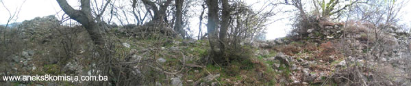
5. Current condition of the property
The on-site inspection in April 2004 established as follows:
Soil at the site of Koštun has been eroded, especially around the towers where there is detritus of fallen stone. In some places, and particularly in the central part, the perimeter walls stand some half a metre above ground, while in other places they have survived up to 3 m. The towers are in good shape. Almost all the site of the fort is covered with scattered stones from the buildings, and around the fort are many stones built-in to dry walls. It would be necessary to mark a path leading from the foothill to the fort.
III - CONCLUSION
Applying the Criteria for the adoption of a decision on proclaiming an item of property a national monument (Official Gazette of BiH nos. 33/02 and 15/03), the Commission has enacted the Decision cited above.
The Decision was based on the following criteria:
A.Time frame
B.Historic value
C.Artistic and aesthetic value
C.iv.composition
D.Clarity (documentary, scientific and educational value)
D.i. material evidence of a lesser known historical era
D.ii. evidence of historical change
D. iv. evidence of a particular type, style or regional manner
F. Townscape/Landscape value
F.i. neaning in the townscape
G. Authenticity
G.i. form and design
G.iv. traditions and techniques
G.v. location and setting
H. Rarity and representativity
H.i. unique or rare example of a certain type or style
The following documents form an integral part of this Decision:
- Photo documentation
- Drawings
Bibliography:
1892. Truhelka, Ćiro, Prilozi rimskoj arheologiji Bosne i Hercegovine. (Contributions to the Roman Archaeology of Bosnia and Herzegovina) Jnl. of the National Museum in Sarajevo IV, Sarajevo, 1982, 340-365.
1895. Radimsky, Vaclav, Archäeologische Tagebuchbältter. Wissenschaftliche Mitteilungen aus Bosnien und Hercegovina III, Wien, 1895., 284-297.
1889. Popović, S. Marko, Dabrica i grad Koštun (Koštur). (Dabrica and the Koštun Fort) Bos. Vila IV, 1889, Sarajevo (Cyrillic).
1954. Šobajić, Petar, Dabarsko polje. (Dabar Plain) Serbian Academy of Science, Serbian ethnographic anthology, Vol LXVII, Settlements and origins of population, Vol 34, Belgrade, 1954, 1-56.
1957. Vego, Marko, Naselja srednjovjekovne bosanske države. (Settlements of the Mediaeval Bosnian State), Sarajevo, 1957.
1957.a Vego, Marko, Prilog topografiji srednjovjekovne Hercegovine. (Contribution to the Topography of Mediaeval Herzegovina), Jnl. of the National Museum in Sarajevo, Archaeology, n.s. XII, Sarajevo, 1957, 267-276.
1959. Ferjančić, Božidar, Vizantijski izvori za istoriju naroda Jugoslavije. (Byzantine Sources for the History of the Yugoslavia Peoples), Vol II, Serbian Academy of Science, Special Editions, Vol CCCXXII, Byzantine Institute Vol 7, Belgrade, 1959. (Cyrillic)
1963. Miletić, Nada, Nakit i oružje IX-XII veka u nekropolama Bosne i Hercegovine. (Adornments and Arms in the Necropolises of Bosnia and Herzegovina) Jnl. of the National Museum in Sarajevo, Archaeology, n.s. XVII, Sarajevo, 1963, 155-178.
1964. Ćirković, Sima, Istorija srednjovekovne bosanske države. (History of the Mediaeval Bosnian State), Belgrade, 1964. (Cyrillic).
1967. Kovačević, Jovan, Od dolaska Slovena do kraja XII vijeka. (From the Arrival of the Slavs to the End of the 12th Century) In:History of Montenegro, Vol I, From Ancient Times to the end of the 12th century. Titograd, 1967, 281-444. (cyrillic)
1972. Basler, Đuro, Arhitektura kasnoantičkog doba u Bosni i Hercegovini. (Architecture of Late Antiquity in Bosnia and Herzegovina), Cultural Heritage Series, “Veselin Masleša”, Sarajevo, 1972.
1973. Bojanovski, Ivo, Rimska cesta Narona-Leusinium kao primjer saobraćajnog kontinuiteta.(The Narona-Leusinium Roman Road as an Example of Traffic Continuity), Almanach of the Centre for Balkan Studies of the Academy of Science and Art of Bosnia and Herzegovina X/8, Sarajevo, 1973, 137-187.
1976. Čović, Borivoj, Bronzane knemide iz Dabrice kod Stoca. (Bronze Knemides from Dabrica near Stolac), Jnl. of the National Museum in Sarajevo, Archaeology, n.s. XXIX/1974, Sarajevo, 1976, 19-33.
1977. Kraljević, Gojko, Rimski novci sa područja Stoca. (Roman Coins from the Area of Stolac), Jnl. of the National Museum in Sarajevo, Archaeology, n.s. XXX-XXXI/1975-1976, Sarajevo, 1977, 217-230.
1978. Kraljević, Gojko, Antički novci u Zemaljskom muzeju pronađeni na području Gacka, Bileće i Trebinja. (Coins of Antiquity in the National Museum Discovered in the Areas of Gacko, Bileca and Trebinje),Tribunija 4, Trebinje, 1978, 155-159.
1982. Anđelić, Pavao, Osnovne značajke teritorijalno političke organizacije u srednjovjekovnoj Bosni. (Basic Characteristics of Territorial and Political Organisation in Mediaeval Bosnia) In: Study on Territorial and Political Organisation of Mediaeval Bosnia, Svjetlost, Sarajevo, 1982, 9-24.
1988. Basler, Đuro, Koštur. Archaeological lexicon, Vol III, page 184. National Museum of Bosnia and Herzegovine, Sarajevo, 1988.
1988. Bojanovski, Ivo, Bosna i Hercegovina u antičko doba, (Bosnia and Herzegovina in Antiquity) Academy of Science and Art of Bosnia and Herzegovina, Works, Vol. LXVI, Centre for Balkan Studies, Vol. 6, Sarajevo, 1988.
1988. Čović, Borivoj, Zagrad, Suzina. Archaeological Lexicon, Vol. III, page 197. National Museum of Bosnia and Herzegovina, Sarajevo, 1988.
1988. Kujundžić, Zilka, Kuriječa. Archaeological Lexicon, Vol. III, page 184. National Museum of Bosnia and Herzegovina, Sarajevo, 1988.
1988. Marijanović, Ivana, Međine, Strupnići. Archaeological lexicon, Vol. III, page 186.
|