Status of monument -> National monument
Pursuant to Article V para. 4 Annex 8 of the General Framework Agreement for Peace in Bosnia and Herzegovina and Article 39 para. 1 of the Rules of Procedure of the Commission to Preserve National Monuments, at a session held from 2 to 8 March 2004 the Commission adopted a
D E C I S I O N
I
The historic site of the necropolis with stećak tombstones of Rajkov kamen in Mijatovci is hereby designated as a National Monument of Bosnia and Herzegovina (hereinafter: the National Monument).
The National Monument consists of the mediaeval stećak tombstones and graves beneath them, and stands on cadastral plot no.76, Land Registry entry no 3, and cadastral plot. 99/1, cadastral municipality Krekovi, and on c.p.. 355/1, Land Registry entry no. 340,c.m. Postoljani, Nevesinje Municipality, Republika Srpska, Bosnia and Herzegovina.
The provisions relating to protection and rehabilitation measures set forth by the Law on the Implementation of the Decisions of the Commission to Preserve National Monuments, established pursuant to Annex 8 of the General Framework Agreement for Peace in Bosnia and Herzegovina (Official Gazette of Republika Srpska no. 9/02) shall apply to the National Monument.
II
The Government of Republika Srpska shall be responsible for ensuring and providing the legal, scientific, technical, administrative and financial measures necessary to protect, conserve and display the National Monument.
The Government of Republika Srpska shall be responsible for providing the resources needed to draw up and implement the necessary technical documentation for the conservation and presentation of the National Monument.
The Commission to Preserve National Monuments (hereinafter: the Commission) shall determine the technical requirements and secure the funds for preparing and setting up signboards with the basic data on the monument and the Decision to proclaim the property a National Monument.
III
To ensure the on-going protection of the National Monument, the following measures are hereby stipulated:
Protection Zone I is applicable to the area defined in Clause 1 para. 2 of this Decision. The following protection measures shall apply in this zone:
- all works on the monuments comprising the architectural ensemble are prohibited other than conservation and restoration works, including those designed to display the monument, with the approval of the Ministry responsible for regional planning in Republika Srpska (hereinafter: the Ministry) and under the expert supervision of the heritage protection authority of Republika Srpska (hereinafter: the heritage protection authority),
- the zone is a potential archaeological site, as a result of which no works involving moving the stećak tombstones or exhuming the graves are permitted
- no works are permitted that could in any way have the effect of altering the site or endangering the necropolis
- the site shall be open and accessible to the public and may be used for educational and cultural purposes
- the dumping of waste is prohibited
The Government of Republika Srpska shall be responsible in particular for carrying out an investigation of the causes of damage and the possibility of repairs to the stećak tombstones.
A protective zone with a width of 100 m from the boundaries within which the National Monument is located is hereby stipulated. Within this zone the following shall protection measures apply:
- all works of any kind that could have the effect of altering the site or altering the landscape are prohibited,
- works of any kind to the infrastructure are prohibited unless with the approval of the relevant ministry and the expert opinion of the heritage protection authority
- the dumping of waste is prohibited.
IV
All executive and area development planning acts not in accordance with the provisions of this Decision are hereby revoked.
V
Everyone, and in particular the competent authorities of Republika Srpska, and urban and municipal authorities, shall refrain from any action that might damage the National Monument or jeopardize the preservation thereof.
VI
The Government of Republika Srpska, the Ministry responsible for regional planning in Republika Srpska and the heritage protection authority of Republika Srpska, and the Municipal Authorities in charge of urban planning and land registry affairs, shall be notified of this Decision in order to carry out the measures stipulated in Articles II to V of this Decision, and the Authorized Municipal Court shall be notified for the purposes of registration in the Land Register.
VII
The elucidation and accompanying documentation form an integral part of this Decision, which may be viewed by interested parties on the premises or by accessing the website of the Commission (http://www.aneks8komisija.com.ba)
VIII
Pursuant to Art. V para 4 Annex 8 of the General Framework Agreement for Peace in Bosnia and Herzegovina, decisions of the Commission are final.
IX
This Decision shall enter into force on the date of its adoption and shall be published in the Official Gazette of BiH.
This Decision has been adopted by the following members of the Commission: Zeynep Ahunbay, Amra Hadžimuhamedović, Dubravko Lovrenović, Ljiljana Ševo and Tina Wik.
Chair of the Commission
Ljiljana Ševo
No: 05.2-02-38/04-1
2 March 2004
Sarajevo
E l u c i d a t i o n
I – INTRODUCTION
Pursuant to Article 2, paragraph 1 of the Law on the Implementation of the Decisions of the Commission to Preserve National Monuments, established pursuant to Annex 8 of the General Framework Agreement for Peace in Bosnia and Herzegovina, a “National Monument” is an item of public property proclaimed by the Commission to Preserve National Monuments to be a National Monument pursuant to Articles V and VI of Annex 8 of the General Framework Agreement for Peace in Bosnia and Herzegovina and property entered on the Provisional List of National Monuments of Bosnia and Herzegovina (Official Gazette of BiH no. 33/02) until the Commission reaches a final decision on its status, as to which there is no time limit and regardless of whether a petition for the property in question has been submitted or not.
At a session held on 1 to 2 July 1999 the Commission issued a Decision to add the Historic site of the necropolis with stećak tombstones of Kalufi in the village of Krekovi, Nevesinje Municipality to the Provisional List of National Monuments of Bosnia and Herzegovina, numbered as 448, under the name Nevesinje-Mijatovci, Rajkov kamen necropolis of stećak tombstones.
Pursuant to the provisions of the law, the Commission proceeded to carry out the procedure for reaching a final decision to designate the Property as a National Monument, pursuant to Article V of Annex 8 and Article 35 of the Rules of Procedure of the Commission to Preserve National Monuments.
II – PROCEDURE PRIOR TO DECISION
In the procedure preceding the adoption of a final decision to proclaim the property a national monument, the following documentation was inspected:
Ÿ Documentation on the location and current owner and user of the property (copy of cadastral plan and copy of land registry entry)
Ÿ Data on the current condition and use of the property, including a description and photographs, data of war damage, data on restoration or other works on the property, etc.
Ÿ The current condition of the property
Ÿ Historical, architectural and other documentary material on the property, as set out in the bibliography forming part of this Decision.
The findings based on the review of the above documentation and the condition of the site are as follows:
1. Details of the property
Location
The historic site of the necropolis with stećak tombstones of Rajkov kamen in the village of Krekovi is located on c.p. no. 76, title no. 100, Land Registry entry no 3, cadastral plot. 99/1, title no. 12, both in cadastral municipality Krekovi, on which there are three mediaeval tombstones and graves beneath consisting of 1 cruciform and 2 chests (complex known as Rajkov kamen) and on c.p. 355/1, title no. 126, Land Registry entry no. 340,c.m. Postoljani, where there are two chests.
The Rajkov kamen necropolis is in the hamlet of Mijatovci, village of Krekovi, to the south-west of the largest necropolis of stećak tombstones in Bosnia and Herzegovina in Kalufi in Krekovi, some 200 m away.
The village of Krekovi is one of the largest in the Nevesinje plain, on the slopes of the southern foothills of Mount Crvanj, where most of the villages in the Nevesinje plain are located. The ancient main road running diagonally across this part of the plain from the south east to the north west ran through or past these villages, and the present-day road follows the same route. The village of Krekovi and the Kalufi and Rajkov kamen necropolises are slightly to the east of this route. Krekovi is reached by a local road from Kifino village.
The Nevesinje plain runs north-south/north-west south east for a distance of 23 km, and is about 7.5 km wide. It is a natural valley caused by the vertical subsidence of the terrain between Mount Crvanj (1921 m) to the east and Mount Velež (1969 m) to the west, at an average altitude of about 850 m above sea level. To the north it opens to the upper Neretva valley, and to the south through the Bregava valley to the lower Neretva. Documentary sources refer to the two forts of Vinčac and Biograd which were in the southern part of the plain, Postoljani, a village to the north of Krekovi, and Konac polje to the north.
Historical information
Because the Neretva gorge was impassable from Konjic to Salakovac (north of Mostar), ever since prehistoric times, and through ancient and mediaeval times, the Nevesinje plain has been a major communications area, across which traffic from the Adriatic shore to the interior passed. It is now an extensively populated area very suitable for rearing livestock. About one third of the land in the field is cultivable.
A large number of prehistoric settlements of the hillfort type with dry-wall fortifications lie alongside the prehistoric road (in Biograd, Bojišti, Nevesinje (Jezdoška hillford), Presjeka, Luka, Slato, Podgrađe and elsewhere) and beside side roads (in Jasena Runjeva glavica, Udrežnje, Trusina, Bratač, Zalom and Lukavac). Many of them were later succeeded by antique-era settlements, the remains of which have been identified in Udrežnje, Biograd, Zovi Do, Lukavac, Kifino selo (Drenovik), Postoljani, Presjeka, Luka andi Zaborani. All the roads from the Gatačko plain (via Zalom), Olug and Kalinovik (via Mount Morina), and from Blagaj and Stolac (via Trusina) met by the Drenovik source in Kifino selo. In Drenovik, the largest Roman settlement in Nevesinje polje developed on both sides of the Zalomka. There is a mediaeval necropolis with 124 stećak tombstones in Drenovik (Bojanovski, 1988, 106-107; Bešlagić, 1971, 384 under Kifino selo).
In the Chronicles of the Doclean priest there is reference to the župa of Nevesinje (Netusigne, Netusini), which belonged to Podgorje (Vego, 1957, 81; Dinić, 1978, 229), together part of Hum, later Herzegovina. Hum land acknowledged the supreme authority of the Serbian rulers of the Nemanjić dynasty from the early 13th to almost the mid 14th century. In the oldest officially maintained records of the Dubrovnik Notariat and Chancellery, dating from 1278, there is reference to trade in slaves from various places in Bosnia and Herzegovina, including Nevesinje (Kovačević Kojić, 1978, 25, n. 40).
Between 1303 and 1306 the overlord of Nevesinje župa was Konstantin Nemanjić, son of Serbia’s King Milutin. It was at this time that Duke Poznanj Purčić makes an appearance on the historical scene. Later, in 1327, he was a witness, along with his brothers, to charters issued by Stjepan II Kotromanić, with the title “duke and župan from Zagorje and Nevesinje”. He was also a liegeman of King Dušan. The Purčić’s were landowners who went over to the side of the Bosnians when the latter began to penetrate into the Neretva valley (Dinić, 1967,40). At that time, there is a record dating from 1391 of one isolated case of a local man from Nevesinje becoming a citizen of Dubrovnik (Kovačević-Kojić, 117).
From 1347, when it came under Bosnian rule during the reign of Ban Stjepan II Kotromanić, and in particular in the first half of the 15th century, there are frequent references in documents in Dubrovnik to places in Nevesinje plain: Konac Polje, Sileno in Nevesigne, Nevesigne de Tucepe, campo Nevesigne, in Nevesinje in Postolach, de Vrangodol de Nevesigne. These references appear in association with robbery, service, the sale of slaves, or small, individual carriage of goods (Kovačević-Kojić, 1978, 114, 117-120).
From the late 14th century to 1404 Nevesinje was ruled by the Sanković’s, who had heritable lands and a manor in the northern part of the Nevesinje plain, in Zaborani village in the small župa of Konac polje, which marched with Kom župa. The road from the Nevesinje plain northwards to Kom fort and thence via Borak to Konjic led through Konac polje. The family necropolis of the Sanković’s is in the nearby village of Biskup near Glavatičevo in the Kom župa. (Vego, 1957, 149).
With the fall of the Sanković family in 1404, Sandalj Hranić extended his own rule over the area. In 1406 he stayed in Nevesinje (Dinić, 1978, 185, n.24), when he also introduced a customs house to Konac polje (Vego, 1957. 51). By the first decade of the 15th century the entire župa was called Nevesinje, though the town of Nevesinje is not mentioned in Dubrovnik archive records until 1429, and in 1435 there is also reference to the main fort of the župa, Vjenačac (Vinačac), with a township below the ramparts. There is earlier and more frequent reference to Podbiograd, the township below the Biograd fort in Nevesinje župa, but as a village. Vinačac was situated above the village of Udrežje (Vego, 1957. 80-81, 125; Kojić-Kovačević, 117-118). The fort of Vjenačac is mentioned among the holdings of Herceg Stjepan in charters dating from 1444, 1448, and 1454 (Dinić, 1978, 204). One of the few communities of members of the Bosnian Church in mediaeval Hum was recorded around Nevesinje, in Konac polje (Ćirković, 1964, 320).
The Ottomans occupied Nevesinje between 1465 and 1466. Until 1468, Nevesinje was the border of the lands of Herceg Vlatko, which ended somewhere in Trusina, while Nevesinje plain was under Ottoman rule (Dinić, 1978, 262). In one document in the Dubrovnik archives, dating from 1469, there is reference to Husein, duke in Nevesinje.
In the name list of the sandžaks of the Herzegovina vilayet for 1468/9, numerous places are listed in the Nevesinje plain that were also known in mediaeval times, or where there are necropolises of stećak tombstones: Živanj, Seljani, Kruševljani, Luka, Kljuni, Kovačići, Bijenja, Postoljani, Bojište, Nevesinje, Žiljevo, Čanje, Rast, Biograd, Bratač, Drežanj, Grabovica, Podgrađe, Slato and Udbina. Krekovi is not listed among them.
2. Description of the property
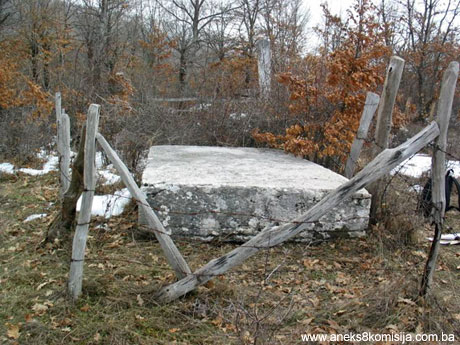
The Rajkov kamen necropolis can be regarded as an integral part of the necropolis in the nearby locality of Kalufi. It is a small necropolis consisting of two sections. The first, known to the locals as Rajkov kamen, consists of one cruciform tombstone with tombstone slab, one tall chest with pedestal, and one chest. About 100 m to the north-west of this group are two isolated chest-shaped stećak tombstones.
1.Cruciform tombstone with tombstone slab. Lying west-east. Size: cross 2.8 m high, 0.6 m wide, 0.32 m thick; slab, 1.9 x 1.6 x 0.3. m. The cross has broken transverse arms. Where the arms intersect is a semi-pommel, and above it a circle filled with radiating lines. Below the covering slab is another slab which covers the grave. Parts of the rectangular tomb chamber emerge from the ground, surrounded by stone slabs set vertically into the ground.
2.Tall chest with pedestal. Lying west-east. Size: Chest: 165 (120) x 0,45 (0,40) x 1,8 m; pedestal: 1,9 x 1,5 x 0,2 m. This tombstone is to the south of the cruciform tombstone. The chest is overturned. Decoration: at the top of the sides a frieze of twining vines with trefoils, and below it five “saracen” arcades. This decoration is the same as that on the overturned chest with pedestal numbered as 21 in the nearby Krekovi necropolis.
3. Chest, about 15 m west of the cruciform tombstone. Lying west-east. Size: 2.34 x 1,65 x 0,4 m. Both graves are surrounded by a fence erected by the locals.
Tombstones 4 and 5 are two chests lying one beside the other facing west-east. Tombstone no. 5 is in fact a large slab with a border of twining vines with trefoils, a twisted band in the centre of the slab, and a rosette.
There are three sites around the main Kalufi necropolis where there are scattered stećak tombstones: 100 m to the west are three chests, there is the Rajkov kamen necropolis also with three chests, and 100 m from this are another two chests. The size of the tombstones and the decorations on at least one of the tombstones in each of these separate groups suggest marked differentiation, probably between different families. The cruciform tombstone is a relatively late form, dating from the late 15th or early 16th century. With these two facts in mind, the Rajkov kamen necropolis probably dates from the 15th to early 16th century, the same period as the main stećak tombstones in Kalufi necropolis.
3. Legal status to date
In the procedure prior to the adoption of a final decision to designate the property, documents on the protection of the property were inspected and it was ascertained that up to 1992 the property had not been placed under protection.
The Institute for the Protection of the Cultural, Historical and Natural Heritage placed the Rajkov kamen necropolis in the hamlet of Mijatovci, Krekovi village, under prior protection status by Ruling no. 177 of 15 October 1999.
The historic site of the necropolis with stećak tombstones of Rajkov Kamen in Mijatovci, Krekovi village, Nevesinje Municipality, is on the Provisional List of National Monuments under serial no. 448 by the name of Necropolis of stećak tombstones Krekovi-Mijatovci.
The Regional Plan of the Republic of Bosnia and Herzegovina to 2002 listed it as Category III.
4. Research and conservation and restoration works
In 1957 Š. Bešlagić visited Nevesinje Municipality and began studying the necropolises of the area. The work was completed between 1964 and 1966 and the results were published in Naše starine XIII in 1972.
No conservation or restoration works have been carried out.
5. Current condition of the property
An on site inspection in February 2004 ascertained the following:
The decorations on the stećak and cruciform tombstones are barely discernible. The corner of the grave beneath the cruciform tombstone has been dug out. Chest 2 is overturned. The decorations are hard to see as a result of weathering. The tall chests and ridge shaped tombstones are overturned.
III – CONCLUSION
Applying the Criteria for the adoption of a decision on proclaiming an item of property a national monument (Official Gazette of BiH nos. 33/02 and 15/03), the Commission has enacted the Decision cited above.
The Decision was based on the following criteria:
A. Time frame
C. Artistic and aesthetic value
C. i. quality of workmanship
C.ii. quality of materials
C.iii. proportions
C. v. value of details
D. Clarity
D. iv. evidence of a particular type, style or regional manner
E. Symbolic value
E.ii. religious value
E.iii. traditional value
F. Townscape/ Landscape value
F.ii. meaning in the townscape
G. Authenticity
G.i. form and design
G.ii. material and content
G.v. location and setting
The following documents form an integral part of this Decision:
- Photodocumentation;
- Drawings
Bibliography
During the procedure to designate the monument as a national monument of Bosnia and Herzegovina the following works were consulted:
1948 Sergejevski, Dimitrije, Rimska cesta na Nevesinjskom polju.(Roman road in Nevesinje plain) Journal of the National Museum in Sarajevo, new series, Vol. III, Sarajevo, 1948, 43-61 (Cyrillic)
1948a Sergejevski, Dimitrije, Putne bilješke sa Nevesinjskog polja (Road signs from Nevesinje plain), Journal of the National Museum in Sarajevo, new series, Vol. III, Sarajevo, 1948, 167-187 (Cyrillic)
1957 Vego, Marko, Naselja bosanske srednjevjekovne države. (Settlements of the mediaeval Bosnian state), Sarajevo, 1957
1962 Bešlagić, Šefik, Stećci i nišani u Vojnom muzeju u Beogradu (Stećak and nišan tombstones in the Military Museum in Belgrade) Newsletter of the JNA Military Museum, Belgrade, 1962, 37-54
1964 Ćirković, Sima, Istorija srednjovjekovne bosanske države (History of the mediaeval Bosnian state), Belgrade, 1964
1967 Dinić, Mihailo, Humsko-trebinjska vlastela (Hum-Trebinje feudal lords), Serbian Academy of Science and the Arts, special ed. Vol. CCCXCVII, Belgrade, 1967, (Cyrillic)
1972 Bešlagić, Šefik, Nevesinjski stećci. (The Nevesinje stećak tombstones), Naše starine XIII, Institute for the Protection of Cultural Monuments of SR Bosnia and Herzegovina, Sarajevo, 1972, 97-122
1978 Dinić, Mihajlo, Zemlje hercega sv. Save (Lands of Herceg St Sava), in: Srpske zemlje u srednjem vijeku (Serbian lands in mediaeval times), Belgrade, 1978, (Cyrillic)
1978 Kovačević-Kojić, Desanka, Gradska naselja srednjovjekovne bosanske države (Urban settlements of the mediaeval Bosnian state), Sarajevo, 1978 (Cyrillic)
1985 Aličić, Ahmed, Poimenični popis sandžaka vilajeta Hercegovina (Name list of the sandžaks of the Herzegovina vilayet), Oriental Institute in Sarajevo, Sarajevo, 1985
1988 Bojanovski, Ivo, Bosna i Hercegovina u antičko doba. (BiH in ancient times), Academy of Science and the Arts of BiH, Works, Vol. LXVI, Sarajevo, 1988
|