Status of monument -> National monument
Pursuant to Article V paragraph 4 of Annex 8 of the General Framework Agreement for Peace in Bosnia and Herzegovina and Article 39 paragraph 1 of the Rules of Procedure of the Commission to Preserve National Monuments, at a session held from 20 to 26 January 2004 the Commission adopted a
D E C I S I O N
I
The historical site of the necropolis with stećaks at Groblje pod Dubom in Ubosko (Ubosko 1), Ljubinje municipality, is hereby designated as a National Monument of Bosnia and Herzegovina (hereinafter: the National Monument).
The National Monument is located on cadastral plot no. 10/9, cadastral municipality Ubosko, Ljubinje Municipality, Republika Srpska, Bosnia and Herzegovina, in the ownership of the Serb Orthodox Church of Ljubinje Municipality.
The provisions relating to protection measures set forth by the Law on the Implementation of the Decisions of the Commission to Preserve National Monuments, established pursuant to Annex 8 of the General Framework Agreement for Peace in Bosnia and Herzegovina (Official Gazette of Republika Srpska No. 9/02) shall apply to the National Monument.
II
The Government of Republika Srpska shall be responsible for ensuring and providing the legal, scientific, technical, administrative and financial measures necessary to protect, conserve and display the National Monument.
The Commission to Preserve National Monuments (hereinafter: the Commission) shall determine the technical requirements and secure the funds for preparing and setting up signboards with the basic data on the monument and the Decision to proclaim the property a National Monument.
III
For the purpose of ensuring the lasting preservation of the national monument the following protection zones are hereby defined:
Protection Zone I consists of the area defined in Clause 1 para. 2 of this Decision, on which are located mediaeval tombstones and the graves beneath them within an active Orthodox cemetery, known as the Pod Dubom cemetery.
The following protective measures shall apply within this Zone:
- The zone is a potential archaeological site, as a consequence of which all works entailing the movement of the stećak tombstones or excavation of the graves are prohibited as are works on the site in the immediate vicinity of the stećak tombstones
- all works are prohibited other than conservation and restoration works, including those designed to display the monument, with the approval of the ministry responsible for regional planning in Republika Srpska (hereinafter: the regional planning ministry) and under the expert supervision of the heritage protection authority of Republika Srpska (hereinafter: the heritage protection authority),
- the site of the monument shall be open and accessible to the public and may be used for educational and cultural purposes,
- the erection of new tombstones and the digging of graves in the immediate vicinity of any of the stećak tombstones is prohibited,
- the dumping of waste is prohibited.
Protection Zone II consists of an area with a radius of 100 metres from the boundaries of Protection Zone I. Within this Zone the following protective measures shall apply:
- all construction or works that could have the effect of altering the area, including changes to the landscape, are prohibited,
- no infrastructure works shall be permitted other than in exceptional cases, to a project approved by the ministry of regional planning and the expert opinion and supervision of the heritage protection authority. The project shall include archaeological works and conservation,
- the dumping of waste is prohibited.
The Government of Republika Srpska shall be responsible in particular for ensuring that a study is made of the causes of damage to the stećak tombstones and the possibility of making good individual stećak tombstones.
IV
All executive and area development planning acts which are not in accordance with the provisions of this Decision shall be revoked.
V
Everyone, and in particular the competent authorities of Republika Srpska, and urban and municipal authorities, shall refrain from taking any action that might damage the National Monument or jeopardize the preservation thereof.
VI
The Government of Republika Srpska, the Ministry responsible for regional planning in Republika Srpska and the heritage protection authority of Republika Srpska, and the Municipal Authorities in charge of urban planning and land registry affairs, shall be notified of this Decision in order to carry out the measures stipulated in Articles II – V of this Decision, and the authorized Municipal Court shall be notified for the purposes of registration in the Land Register.
VII
The elucidation and accompanying documentation form an integral part of this Decision, which may be viewed by interested parties on the premises or by accessing the website of the Commission (http://www.aneks8komisija.com.ba)
VIII
Pursuant to Article V paragraph 4 of Annex 8 of the General Framework Agreement for Peace in Bosnia and Herzegovina, decisions of the Commission are final.
IX
This Decision shall enter into force on the date of its adoption and shall be published in the Official Gazette of BiH.
This Decision has been adopted by the following members of the Commission: Zeynep Ahunbay, Amra Hadžimuhamedović, Dubravko Lovrenović, Ljiljana Ševo and Tina Wik.
Chairman of the Commission
Ljiljana Ševo
No: 05.2-2-699/03-2
21 January 2004
Sarajevo
E l u c i d a t i o n
I – INTRODUCTION
Pursuant to Article 2, paragraph 1 of the Law on the Implementation of the Decisions of the Commission to Preserve National Monuments, established pursuant to Annex 8 of the General Framework Agreement for Peace in Bosnia and Herzegovina, a “National Monument” is an item of public property proclaimed by the Commission to Preserve National Monuments to be a National Monument pursuant to Articles V and VI of Annex 8 of the General Framework Agreement for Peace in Bosnia and Herzegovina and property entered on the Provisional List of National Monuments of Bosnia and Herzegovina (Official Gazette of BiH no. 33/02) until the Commission reaches a final decision on its status, as to which there is no time limit and regardless of whether a petition for the property in question has been submitted or not.
At a session held on 1 and 2 July 1999 the Commission adopted a decision to add the historic site of the necropolis with stećak tombstones at the cemetery pod Dubom in Ubosko (Ubosko 1), Ljubinje Municipality to the Provisional List of National Monuments, under serial number 355 and the title Necropolis of stećak tombstones Ubosko 1.
Pursuant to the provisions of the law, the Commission proceeded to carry out the procedure for reaching a final decision to designate the Property as a National Monument, pursuant to Article V, paragraph 4 of Annex 8 and Article 35 of the Rules of Procedure of the Commission to Preserve National Monuments.
II – PROCEDURE PRIOR TO DECISION
In the procedure preceding the adoption of a final decision to proclaim the property a national monument, the following documentation was inspected:
Ÿ Documentation on the location and current owner and user of the property (copy of cadastral plan and copy of land registry entry)
Ÿ Data on the current condition and use of the property, including a description and photographs, data of war damage, data on restoration or other works on the property, etc.
Ÿ The current condition of the site
Ÿ Historical, architectural and other documentary material on the property, as set out in the bibliography forming part of this Decision.
The findings based on the review of the above documentation and the condition of the site are as follows:
1. Details of the property
Location
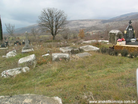
The historic site of the necropolis with stećak tombstones at the pod Dubom Cemetery (Ubosko 1) is located on cadastral plot no. 10/1, cadastral municipality Ubosko in Ubosko, no. of title deed 69, owner Serbian Orthodox Parish in Ljubinje, Ljubinje Municipality.
The village of Ubosko is located within Ubosko polje, some 2 km east of the main Stolac-Ljubinje-Trebinje road. The road forks off at Žegulje pass and leads to Ubosko polje via Rđus. It is some 8 km from Ljubinje. The entire area has marked upland karst features, with scrub woods and two karst valleys: the Ubosko and Ljubija valleys. The Ubosko valley is roughly elliptical in form, approx. 2 km long and 800-1000 m wide. The largest settlement in the valley is Ubosko, a name known in the late mediaeval period. The settlement is located along the eastern edge of the valley. The houses and arable lands are located in the lowlands or on the rather more sunny side of the valley. The principal economic activity of the inhabitants, dictated by geographical conditions, was cattle raising, with the cultivation of crops as a secondary activity. The Ubosko 1 necropolis is located at the edge of the valley, west of the local road running through the valley, within the contemporary Serbian Orthodox village cemetery. It is located on outlying, slightly elevated terrain, not far from the village houses. An old Orthodox cemetery, which is still in use, lies to the south and west of the necropolis. Tombstones in the shape of crosses and decorated in a manner reminiscent of stećak tombstones are located primarily in the west. This Orthodox cemetery is the main cemetery in the village of Ubosko, while necropolis 1 is the largest and the most important in Ubosko valley and one of the largest necropolises in the Ljubinje region. In addition to the two most important necropolises of stećak tombstones within the Ubosko valley, Ubosko 1 and Ubosko 2, there is a number of smaller necropolises which are believed to have belonged to families (with 5-10 stećak tombstones) or to a clan (up to 30 stećak tombstones). Of these, the two necropolises located in the southern and southeastern regions of the Ubosko valley are the most striking. Crkvina necropolis is distinguished by its 48 stećak tombstones, and is located at the outer eastern boundary of the valley, to all appearances on a tumulus with a diameter of some 25 meters, at its base to the west. Adjacent to the necropolis are two smaller grave mounds . All monuments are of chest type, four of which have pedestals. They are of coarse workmanship, with ornament. They basically lie west-east, although there are others facing in every other direction. Some 300 meters to the west of Crkvine is Grebusa, with the remains of what is believed to have been a mediaeval church. The site is located by the road which leads from Rđus down to the Ubosko valley. Adjacent to that is a quarry from which stone was excavated to make the stećak tombstones, and a well. Local tradition preserves the memory of a church, and the remains of foundations, most probably with an apse at the east end, are visible on the ground. There are five chest-shaped stećak tombstones, one large slab stećak and two extensively damaged stećak tombstones within the necropolis. A large sunken slab (200 x 125 cm) lies west-east and bears an epitaph; its position suggests it could have been inside the church. At the head of the slab (the western edge), on the horizontal surface, are a moulded crescent moon and four-petalled rosette or star, below which is the epitaph, in Bosnian Cyrillic: «A SE LEŽI DABIŽIV RADOVANOVIĆ. ČOČE, TAKO DA SI BLAG!»,[Here lies Dabiživ Radovanović], meaning Man, be gentle with me (Bešlagić, 1965, 142, Vego, 1964, 47, No. 98). A moulded frieze consisting of a wavy line with trefoils can be seen on a damaged chest-shaped tombstone. This necropolis too must have had even more monuments which have disappeared with the passage of time.
Historical information
The area where Ljubinje municipality is located, between Stolac and Popovo polje, has not yet been fully explored. A number of hill forts and tumuli found there are believed to date back to the Bronze or Iron Age. In antiquity, a Roman road used to run from Stolac via Žegulje and Ljubinje. The remains of Roman buildings have been found in Žegulja and the remains of a Roman settlement have been found in Ljubinje. No true archaeological research has yet been carried out in the area.
In the early mediaeval period the territory of present-day Ljubinje municipality belonged to the large župa or county of Popovo. It was the northernmost part of Popovo župa, adjacent to Dubrave and Dabar župas. One boundary is formed by the natural boundary on Žegulja spur, geographically separating the Trebisnjica and Bregava basins; another by the Sitnica and Kulaš massif surrounding Popovo and Dabar župas (Anđelić, 1983, 8-69). Politically, the region belonged to the district of Hum, ruled by the Nemanjić’s from the 12th to almost the first half of the 14th century, with brief interruptions. From 1324 to 1326 Bosnia’s ban Stjepan II Kotromanić occupied that area of Hum. By 1373, his successor Tvrtko had extended the borders of the Bosnian state southwards to include the entire area of Hum and to the east as far as Kotor and Onogošt (Ćirković 1964, 88-90, 162). The ascent of the Kosača family began during Tvrtko's reign. Vlatko Vuković, of that family, was granted most of Hum, over which the family maintained complete control under Sandalj Hranić (1392-1435), Herzeg Stjepan Vukčić Kosača (1435-1466) and his sons until 1482. The Ottomans occupied the area around Ljubinje between 1465 and 1467 (Šabanović, 1959, 160). The Ljubinje nahija (administrative district) was entered in the 1468/1469 census of the Bosnian sandžak. In the first census by name of the sandžak, the vilayet (province) of Herzegovina, several places were listed in this region (Aličić, 1985, various).
The region seems to have been uninhabited in the early mediaeval period, since in the 14th and 15th centuries numerous katun Vlachs belonging to Vlachi inferiores settled there. According to historical sources dating from the 1470s, one of the four katuns of the Herzegovina Vlachs, «the Burmaz clan/tribal unit», the largest of the Vlach fraternities, inhabited the Ubosko valley. At that time, Milobrat Obradovićs was the katunar or leader of one Burmaz group in Ubosko (Hrabak, 1956, 29-30, 33; Anđelić, 1983, 67; Ratković, 2000, 135). It is not known how many other katuns there were or which Vlach groups they belonged to. Ratković refers to three katuns in Ubosko (Ratković, 2002, 153). Ubosko seems to have been one of the more densely populated areas of the Ljubinje region in the first half of the 15th century, as evidenced by four documented necropolises and two epitaphs on stećak tombstones: that of Pomoćan Ostojić on stećak number 7 in Ubosko 1 necropolis and of Dabiživ Radovanović in the Grebuše necropolis, with the remains of what was probably a mediaeval church (Bešlagić, 1965, 142, 151). Dabiživ Radovanović was the “pride of the lead”, the son of Radovan from Milobrat Obradović's jamaat in the largest Vlach clan of Burmaz (Tošić, 1999, 124; Aličić, 1985, 137). The last reference to him is in Dubrovnik sources in 1447, which means that his tombstone cannot be more recent than the last quarter of the 15th century.
2. Description of the property
The Ubosko 1 necropolis of one of the larger necropolises in the Ljubinje region, along with those in Vlahovići, Dubočići and Premilovo polje. There are 57 stećak tombstones in this necropolis: 2 ridged (gabled), 32 chests, 22 slabs and 1 cruciform stećak on a slab. There is also a sizeable well with a round arch at the edge of the necropolis, near the local road. The rows are arranged at right-angles to the main orientation of the tombstones, which lie west-east, or more precisely, north-west/south-east, except for four stećaks standing at a right angle to the remainder. The orientation of the stećaks corresponds to the lie of the land.
In addition to distinctive carvings showing various animals and human figures, a number of large slabs (Nos. 17, 18, 43) measuring 300 (310) x 285 x 40 cm, stand out in size and decorative carvings. 13 stećak tombstones are decorated.
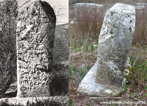
1. A tall gable (150 x 155 x 85 cm) with a pedestal (190 x 195 cm). The stećak narrows at the base. There is a twisted band between the gable and a chest. The north-west face bears a stylized moulded Greek cross with arms broadening slightly, surrounded by a moulded band. The cross bears two concentric circular wreaths at the centre and a circle on each of the arms. A fabulous beast with no legs features below the cross, its body bent, an with two concentric circles attached to its head. There is are the carved figures of a deer and a bird on the south-east face. The deer's head is bent toward its outstretched forelegs; its hind legs are unusually long and tucked under its body. A hunting scene is illustrated on the north-east face, with a hunter on horseback is throwing a spear at a deer.
2. A fairly large, chipped, sunken chest (169 x 110 x 50 cm). The tops of the vertical sides are surrounded by a highly moulded twisted band. On the north-west face is a sizeable carved cross with two small crosses above it. The arms of the large cross are of equal length and terminate in circles. Each side face features a series of simple graphic figures reminiscent of a wheel dance. Some of the figures are damaged.
3. A very low chest standing on a pedestal. The chest is small in size (118 x 82 x 17 cm). The pedestal is 15 cm wider all round. The stećak is partly sunk into the ground, and its corners are chipped. There is an original relief on the horizontal surface, consisting of a double cross the transoms of which end in sizeable spirals. The upright terminates at the top in a rosette on the upper end and stands on a semi-circular pedestal with a rosette. There is a carved bird on each side of the upper horizontal arm between the upright and the spiral.
4. A chest of average workmanship and in a fair state of preservation. There is a carved cross with arms that widen at the ends on the north-west face, with a pommel between each of the arms on the upper side.
5. A tall gable standing on a pedestal (172 x 61 x 100 cm), well carved and preserved, leaning slightly to the east. It lies north-east and narrows towards the base. There is an elaborately carved strip on all the vertical sides, between the gable and the chest. The north face bears a rectangular shield with a sword carved beneath. An animal is shown over the full height of the shield, with the features of a deer with raised head, except that it has a long, forked tail curved over its back. The gable end features a long-tailed animal with a snake facing it. The south face bears scene of two animals fighting, reminiscent of a lion and a dragon in combat. The «dragon» has a serpentine body, two wings and a curved tail; its head is shown with wide-open jaws. Two birds facing other are carved on the gable end. A row of six male figures carrying swords is shown on the west face. The first warrior is facing the other five in a row, starting with a horseman and followed by four foot-soldiers, the first of whom is carrying a drawn bow and an arrow. There are two scenes shown on the east face: a hunter spearing a bear in the belly, in the southern half, where the figure of the man is small in comparison to the bear; and a deer hunt on the northern half. There is a falcon above the deer, in pursuit of the animal, while a hunter is targeting the deer with an arrow.
6. A tall chest (172 x 70 x 80 cm), damaged, leaning and sunken. A human figure cam be made out on the west face. On the upper half of the east face which is still above ground the upper part of the body of a deer can be seen. There is a relief design on the north side face, which cannot be clearly made out.
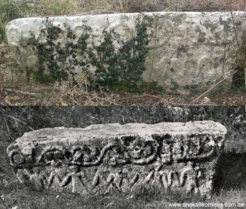
7. A tall chest on a pedestal (chest measuring 145 x 40 x 105 cm; pedestal), narrow, lightly chipped and cracked, but well cut. It lies north – south. A «kamenica» is carved on the horizontal surface. A horseman with shield and sword is shown on the north face, with beneath him a five-line epitaph, damaged by weathering and only partly legible. Vego deciphered the inscription, which is written in Bosnian Cyrillic «+OVDI UMRH...MILO OSTOJE NECI. A SE PI [SA]... (Here I, Milo, Ostoja's nephew, died. Written by...) (Vego, 1964, 44-45, No. 97). An almost illegible epitaph consisting of six oblique lines can be seen on the south face beneath two rosettes within wreaths framed with slanting parallel lines. According to Bešlagić, the epitaph reads «ASE LEŽE POMOĆAN OSTOIĆ, KO MENE... NKO ME... (Bešlagić, 1965, 134, 160). The patronymic Ostojić appears twice in Ivan Pripčinović's book in the second half of the 14th century (Hrabak, 1956, 37), and from an analysis of the lettering it dates from the 15th century (Bešlagić, 1965, 160; Vego, 1964, 44-45). The west face has a carved frieze of a series of four-leaved rosettes in circular wreaths, beneath which is a band of incised oblique parallel lines. Beneath the frieze are «Romanesque» arcades with 4 intercolumns. The arcades contain several letters as a continuation of the epitaphs on the faces. The same motif of frieze and arcades is found on the east side.
8. A tall chest of good workmanship with a pedestal (chest measuring 147 x 87 x 97 cm, pedestal 180 x 120 cm). The chest narrows towards the base, and is chipped on the south side. There is a carved decoration in the shape of a simple cross on the horizontal face. At the top of the vertical faces is a carved frieze of a wavy line with trefoils. The west face bears a scene in bas relief of a deer hunt with a hunter and a falcon, is shown beneath the frieze. The east face has several figures carved in relief. At the base is what is probably a doe being chased by a dog, with three birds above the doe. At the same level as the birds, on the other side of the scene, is a female figure with her hands on her hips, and bird with unusually long legs standing on each shoulder. On the north side face is a line of four hinds in a shallow relief with birds on their backs similar to those on the woman's shoulders on the same tombstone. Beneath the first hind is a fabulous beast reminiscent of a cock, from Bešlagić's detailed description (Bešlagić, 1965, 136).
9. A chest (186 x 80 x 55 cm), damaged at the southern end and sunken into the ground. The top of the vertical sides is decorated with a frieze of a wavy line with trefoils. The west face shows a wheel dance with male and female figures with hands raised to shoulder level. The wheel dance continues on the north side face. The east face shows part of a horse and rider. The south side face above ground level bears only a highly moulded frieze.
10. A chest sunk into the ground. Parts of several human figures with arms raised and relatively large hands and fingers together are to be seen on the east side face.
11. A large, tall chest with a pedestal (chest 180 x 88 x 220 cm, pedestal 220 x 180 x 30 cm). The chest narrows towards the base. On all vertical sides near the top is a carved frieze of a wavy line with trefoils. Below this is a band of oblique parallel lines. The west front face contains the carved scene of a horseman whose reins are held by a female figure. The woman is holding a spear or a flag in the other hand. There is an eight-leaf rosette in a circular wreath above the horseman's head. Both side faces bear a large four-leaf rosette encircled by an denticulated wreath. The east front face has the figure of a deer. The south side face has arcades of Saracenic arches and 6 intercolumns. The north front face is similar, the only difference being that there is a series of rosettes arranged in wreaths between the arcades and the frieze.
12. A large cruciform monument with a slab, of good workmanship and well preserved. Dimensions: the cross is 325 cm tall and 165 cm wide (including the transoms), and 35 cm thick; the slab measures 215 x 160 x 40 cm. Both vertical sides of the cross are identically decorated with carvings. The cross is outlined by a band of oblique parallel lines. An eight-leaf rosette is carved in the centre of the cross. The same motif is found on the three bars of the cross. The horizontal face of the slab is outlined in the same way as the cross.
13. A long slab (250 x 220 x 35 cm). Damaged by weathering. Within a border of oblique parallel lines is a crescent moon in one corner and a rosette in another.
The necropolis dates back to the 14th and the 15th centuries but judging by the epitaphs on stećak No. 7 and the chronology of epitaphs on stećaks at nearby localities in the Ljubinje and Stolac regions, the development of these necropolises was at its height in the second half of the 15th century (Bešlagić, 1965, 162; Tošić, 1999, 128). The patronymic Ostojić appears twice in Ivan Pripčinović's book from the second half of the 15th century (Hrabak, 1956, 37).
3. Legal status to date
In the procedure prior to the adoption of a final decision to designate the property, documents on protected properties were consulted and it was ascertained that the site was not protected.
The historic site of the necropolis with stećak tombstones at the pod Dubom cemetery in Ubosko (Ubosko 1), Ljubinje Municipality, is on the Provisional List of National Monuments, under serial number 355 and the name Ubosko 1 necropolis of stećak tombstones.
The Regional Plan for the Republic of Bosnia and Herzegovina to 2002 listed the necropolis as a Category II monument.
4. Research and conservation and restoration works
Between 1960 and 1963, Š. Bešlagić visited and studied necropolises within the territory of Ljubinje Municipality as part of his research into stećak tombstones in Herzegovina, and published his findings in Naše starine (Our Antiquities) X, in 1965.
No restoration or conservation works have been conducted to date.
5. Current condition of the property
The following was established during an on-site inspection in January 2004:
The stećak tombstones are of very good workmanship, but many monuments have been damaged by weathering, or have sunk into the ground; some have fallen over or are broken or chipped. By comparison with the situation in the 1960s, patches of lichen have spread over much of the surface of the tombstones, concealing the decoration on some stećaks or making them barely visible.
The two groups of stećaks at the eastern and south-eastern ends of the necropolis are overgrown with thorny shrubs and overhung with tree branches and scrub oak, which makes them difficult to reach.
The burial ground, which occupies an area of 400 m2, is not fenced off and has room for new graves. There is a noticeable tendency not to touch the old Orthodox graves in the west and south parts of the necropolis. Instead, huge family vaults are being constructed ever closer to the stećak tombstones within the area to the north west (from stećak number 1 to stećak number 7). This practice detracts from the uniformity of the necropolis as new tombstones, with their dimensions and materials (mainly black marble), conceal the stećaks from sight. This can be observed in almost every cemetery in Herzegovina.
III - CONCLUSION
Applying the Criteria for the adoption of a decision on proclaiming an item of property a national monument, (BiH Official Gazette, No. 33/02 and 15/03), the Commission has enacted the Decision cited above.
The Decision was based on the following criteria:
A. Time frame
B. Historical value
C. Artistic and aesthetic value
C.i. quality of workmanship
C.ii. composition
D. Clarity
D. ii. evidence of historical change
F. Townscape/ Landscape value
F.ii. meaning in the landscape
G. Authenticity
G.i. form and design
G.ii. material and content
G.v. location and setting
G.vi. spirit and feeling
H. Rarity and representativity
H.i. unique or rare example of a certain type or style
The following documents form an integral part of this Decision:
- Photo documentation;
- Drawings
Bibliography
During the procedure to proclaim the necropolis a national monument of BiH, the following works were consulted:
1956. Hrabak, Bogumil, “O hercegovačkim vlaškim katunarima prema poslovnoj knjizi dubrovčanina Dživana Pripčinovića” (On Herzegovina's Vlach katuns acording to the the business records of Dživan Pripčinović from Dubrovnik) Journal of the National Museum, History and Ethnography, new series, No. IX, Sarajevo, 1956, 29-39 (Cyrillic).
1964 Ćirković, Sima, Istorija srednjovjekovne bosanske države (History of the Mediaeval Bosnian State) Belgrade,
1964 Vego, Marko, “Zbornik srednjovjekovnih natpisa Bosne i Hercegovine” (Collection of mediaeval inscriptions of Bosnia and Herzegovina) Volume II, National Museum of Bosnia and Herzegovina, Sarajevo, 1964, No. 97, 98, pp 44-47.
1964. Bešlagić, Šefik, “Ljubinje – srednjovjekovni nadgrobni spomenici” (Ljubinje – Medieval tombstones) Our Antiquities X, Institute for Protection of Cultural Monuments of S. R. Bosnia and Herzegovina, Sarajevo, 1965, 113-165.
1983. Anđelić, Pavao, “Srednjovjekovna župa Popovo” (the mediaeval county of Popovo) Tribunia, No. 7, Trebinje, 1983, 61-79.
1985. Aličić, Ahmed, Poimenični popis sandžaka vilajeta Hercegovina (List of sub-provinces of Herzegovina province).Oriental Institute, Sarajevo, Sarajevo, 1985
1999. Tošić, Đuro, “Prilog identifikovanju i datovanju vlaških stećaka u istočnoj Hercegovini” (Towards identification and dating of Vlach stećaks in East Herzegovina) Historical evidence, Year LXXII, No. 1-2, Podgorica, 1999, 105-129.
2002. Ratković, Aleksandar, Ljubinje, srednjovjekovne nekropole i crkvišta (Ljubinje, Medieval necropolises and Churches).Ljubinje Municipality, Ljubinje, 2002.
|