Status of monument -> National monument
Pursuant to Article V para. 4 Annex 8 of the General Framework Agreement for Peace in Bosnia and Herzegovina and Article 39 para. 1 of the Rules of Procedure of the Commission to Preserve National Monuments, at a session held from 7 to 11 October 2003 the Commission adopted a
D E C I S I O N
I
The archaeological site of the Old Dubrovnik Fort, Višnjica near Ilijaš is hereby designated as a National Monument of Bosnia and Herzegovina (hereinafter: the National Monument).
The National Monument is on a site comprising cadastral plot 82/1, Ilijaš Municipality, Solila plot, in the possession of Sarajevo šume (Sarajevo Forests) of Sarajevo, Federation of Bosnia and Herzegovina, Bosnia and Herzegovina.
The provisions relating to protection and rehabilitation measures set forth by the Law on the Implementation of the Decisions of the Commission to Preserve National Monuments, established pursuant to Annex 8 of the General Framework Agreement for Peace in Bosnia and Herzegovina (Official Gazette of the Federation of BiH nos. 2/02 and 27/02) shall apply to the National Monument.
II
The Government of the Federation of Bosnia and Herzegovina (hereinafter: the Government of the Federation) shall be responsible for ensuring and providing the legal, scientific, technical, administrative and financial measures necessary to protect, conserve, display and rehabilitate the National Monument.
The Government of the Federation shall be responsible for providing the resources for drawing up and implementing the necessary technical documentation for the rehabilitation of the National Monument.
The Commission to Preserve National Monuments of Bosnia and Herzegovina (hereinafter: the Commission) shall determine the technical requirements and secure the funds for preparing and setting up signboards with the basic data on the monument and the Decision to proclaim the property a National Monument.
III
To ensure the on-going protection of the National Monument, the following measures are hereby stipulated:
Protection Zone I comprises part of c.p. 82/1, which contains the old Dubrovnik fort and the immediate environs, from Šija to “Varoši” on a north-east/south-west axis, and from the north towards the rocky area on which the fort stands, the road to Kopočić (the cadastral entry gives no c.p. no. for the road) and c.p. 1040 and 1041 on which the necropolis with stećak tombstones of prince Batić in Kopočić stands.
In this zone, the following measures shall apply:
§ all works are prohibited other than research, conservation and restoration works carried out to a design project approved by the Federal Ministry responsible for regional planning (hereinafter: the regional planning Ministry) and under the expert supervision of the heritage protection authority of the Federation of Bosnia and Herzegovina (hereinafter: the heritage protection authority),
§ the site of the National Monument shall be open and accessible to the general public,
§ the site may be used for educational and cultural purposes,
§ all construction, felling of timber, or works that could have the effect of altering the site are prohibited, as are the erection of temporary facilities or permanent structures not intended solely for the protection and presentation of the National Monument,
§ the dumping of all kinds of waste is prohibited,
§ all motor traffic is prohibited.
Protection Zone II consists of a strip 50 m from Protection Zone I.
In this zone all works that could have the effect of altering the natural surroundings of the monument are prohibited.
The Government of the Federation shall be responsible in particular for ensuring that the following protection measures are enforced:
§ Prohibit the quarrying of stone from the Misoèa quarry on the rocky area on which the National Monument stands.
§ Determine the technical conditions for the quarrying of stone in this Protection Zone, such as shall not in any way endanger the National Monument, and which must include the approval of the heritage protection authority.
§ Restore the geomechanical nature of the terrain that has been altered by the extraction of stone so as to ensure the structural stability of the National Monument.
IV
All executive and area development planning acts not in accordance with the provisions of this Decision are hereby revoked.
V
Everyone, and in particular the competent authorities of the Federation of Bosnia and Herzegovina, the Canton, and urban and municipal authorities, shall refrain from any action that might damage the National Monument specified in Clause I of this Decision or jeopardize the preservation and rehabilitation thereof.
VI
The Government of the Federation, the regional planning Ministry, the Federation heritage protection authority, and the Municipal Authorities in charge of urban planning and land registry affairs, shall be notified of this Decision in order to carry out the measures stipulated in Articles II to V of this Decision, and the Authorized Municipal Court shall be notified for the purposes of registration in the Land Register.
VII
The elucidation and accompanying documentation form an integral part of this Decision, which may be viewed by interested parties on the premises or by accessing the website of the Commission (http://www.aneks8komisija.com.ba)
VIII
Pursuant to Art. V para 4 Annex 8 of the General Framework Agreement for Peace in Bosnia and Herzegovina, decisions of the Commission are final.
IX
This Decision shall enter into force on the date of its adoption and shall be published in the Official Gazette of BiH.
This Decision has been adopted by the following members of the Commission: Zeynep Ahunbay, Amra Hadžimuhamedović, Dubravko Lovrenović, Ljiljana Ševo and Tina Wik.
Chair of the Commission
Amra Hadžimuhamedović
Decision No: 06-6-14/03-3
8 October 2003
Sarajevo
E l u c i d a t i o n
I – INTRODUCTION
Pursuant to Article 2, paragraph 1 of the Law on the Implementation of the Decisions of the Commission to Preserve National Monuments, established pursuant to Annex 8 of the General Framework Agreement for Peace in Bosnia and Herzegovina, a “National Monument” is an item of public property proclaimed by the Commission to Preserve National Monuments to be a National Monument pursuant to Articles V and VI of Annex 8 of the General Framework Agreement for Peace in Bosnia and Herzegovina and property entered on the Provisional List of National Monuments of Bosnia and Herzegovina (Official Gazette of BiH no. 33/02) until the Commission reaches a final decision on its status, as to which there is no time limit and regardless of whether a petition for the property in question has been submitted or not.
On 7 January 2003 Ilijaš Municipality submitted a petition for the designation of the Old Dubrovnik Fort as a National Monument of Bosnia and Herzegovina.
Pursuant to the provisions of the law, the Commission proceeded to carry out the procedure for reaching a final decision to designate the Property as a National Monument, pursuant to Article V of Annex 8 and Article 35 of the Rules of Procedure of the Commission to Preserve National Monuments.
II – PROCEDURE PRIOR TO DECISION
In the procedure preceding the adoption of a final decision to proclaim the property a national monument, the following documentation was inspected:
§ Documentation on the location and current owner and user of the property (copy of cadastral plan and copy of land registry entry)
§ Data on the current condition and use of the property, including a description and photographs, data of war damage if any, data on restoration or other works on the property if any, etc.
§ Current condition of the property
§ Historical, architectural and other documentary material on the property, as set out in the bibliography forming part of this Decision.
The findings based on the review of the above documentation and the condition of the site are as follows:
1. Information on the property
Location
The Old Dubrovnik Fort stands on a steep, narrow karst prominence of Huma hill, above Sastavci, the confluence of Zenika brook and the river Misoča. The fort stands on naturally terraced ground extending from the north-east, i.e. Huma hill, to the south-west, ending in the steep slope descending towards Sastavci, where stone has been quarried since 1972 in the quarry on 9 km of the river Misoča. The area is remote, waterless and poor.
There is easier access to the fort from the village of Kopošići, 1 km away, by a well-cobbled road leading between the foot of Nabožića hill and Tisovika hill. The necropolis of Prince Batić is in Kopošići. The road is now overgrown, and constituted the front line during the 1992-1995 war; the area is still mined today (2003).
Other possible ways to reach the fort are by the long slope some ten kilometres from the river Misoča or from the quarry at Sastavci.
The fort is about 10 km. from Ilijaš.
Historical information
In the thirteenth century the area between the Sarajevo and Visoko plains belonged to the old Bosnian county of Vidogošća-Vogošća. In the second half of the fourteenth and in the fifteenth century Dubrovnik and its surroundings were the main political centre of this county. The earliest reference to it is in the Dubrovnik archives, dating from 11 June 1404. The fort grew in size, importance and degree of development with the influx of the military and officials. Individual feudals also settled in such forts. Given its date of origin, its proximity to Kopošići with its necropolis of Prince Batić, and the fact that it was the political centre of the county and then of the nahija (administrative area) of Dubrovnik, the fort probably belonged to the Mirković family to which Prince Batić also belonged.
There is no exact information about the origins of the fort. Fra Ivan Jukić refers to people from Dubrovnik smelting silver and iron ore here and erecting the fort with the permission of Kulin ban. (Filipović, 1924, 103.)
Bobovac and Visoki came under Ottoman rule in 1463, and the assumption is that Dubrovnik was conquered at the same time. During the reign of Sultan Mehmed II the fort had a garrison headed by a dizdar. At this time, too, a mosque was built in the fort. There are references to Dubrovnik in Ottoman-Hungarian treaties, and in Gazi Husrev-beg’s endowment of 1531, as Dobronik. The surrounding nahija was also called Dubrovnik. There was a garrison in the fort until 1655, but some years later it was relocated elsewhere.
A letter from the Sarajevo qadi dated 12 December 1709 suggests relocating an official from the mosque in Dubrovnik to the Imperial Mosque in Sarajevo, given that the fort was abandoned, the mosque was in ruins, and there was no need to repair it. (Kreševljaković, 1953, 16). In the administrative reforms of the eighteenth century, the western part of Dubrovnik nahija became part of the regional entity of Nadvisoko, and the eastern part was merged with the Sarajevo region.
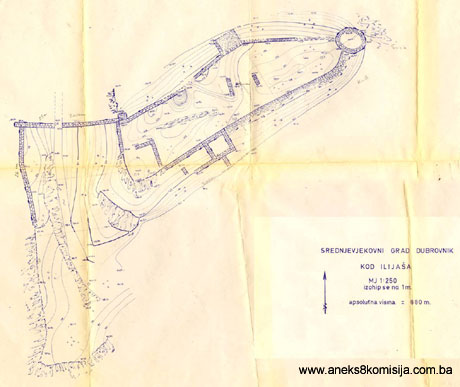
2. Description of the property
The fort is irregular in shape, adapted to the configuration of the terrain. It was built on a level area that descends gradually towards the rivers from the highest plateau, Grad (Fort), via Bedem (ramparts), Varoš (town) and Ugrada. The fort stands at an altitude of 882 m, and the confluence of the rivers at 569 m. This topographically prominent site, protected to the north by the Huma cliffs, is extremely well adapted for defensive purposes. The cobbled road already referred to runs through “Šija”, a naturally narrow valley between Stup hill to the north-east and the Fort on the opposite site, towards Kopošići in which the necropolis of Prince
Batić is located. According to tradition, there was a law court in Šija. Here, too, was the intersection of the roads leading towards Visoko and Olovo, political and economic centres at that time (Mazalić, 1939, 35).
On Stup hill was a detached watchtower, of the kind that was usually an integral part of the mediaeval defence system of fortifications.
The mediaeval fort stood on the elevation known as Grad, and consisted of two sections: the upper, main part of the fortifications, 72 m in length, varying in width from 5 to 17.5 m, and with a total area of 902 sq.m. extending east-west. The average thickness of the walls is 1.40 m, increasing in places to as much as 1.50 m. The walls of the bailey are thinner, varying from 0.70m to 1.10 m. They are built of the local stone, natural limestone slabs, with only the exterior dressed to make the wall somewhat more even. This revetment enclosed the core of the wall, filled with a mixture of mortar and quarry stone. At the eastern end is a circular tower (diameter 7.5 m) and on the north wall are two rectangular towers, one projecting out from the face of the wall (measuring 6.2 x 5 m) and the other standing on the highest elevation of the fort, which had already been pulled down some twenty years ago. Alongside the south wall is another projecting rectangular tower (measuring 7 x 6 m), with a structure (measuring 9 x 5 m) of unknown purpose abutting onto its west wall. Roughly in the centre of the fort is a well, cut into the rock and surrounded with large blocks. Within the ramparts of the fort the remains of other walls have been observed, about 1 m thick, but without archaeological investigations it is impossible to say what they may have been for. The perimeter walls have been almost demolished above a height of some 0.5 m from ground level, other than the outer walls, which would be better described as retaining walls, of the towers projecting out from the wall casing, which are on lower ground and have survived to a height of up to 6 m. One can only guess at where the entrance to the mediaeval upper fort was, since the north-western wall, built on the rock, has been partly demolished.
Alongside the western wall of the upper part of the fortifications is the lower bailey, which was probably levelled and turned into a bastion in Ottoman times. The main gates to the fort were probably reached from this bailey via an access road to the north, but there are no remains of the gate.
To the south-west of the fort, under the bastion, is the toponym “Varoš”. (Filipović, 1924, 102). This is still buried under some piles of stone, perhaps from earlier demolitions on the site, but of uncertain origin and purpose. Among the locals, there is still a tradition that a varoš stood beneath the fort. There is now no evidence of this on the site (Mazalić, 1939, 34).
3. Legal status to date
Pursuant to the law, and by Ruling of the Institute for the Protection of Cultural Monuments of SR BiH no. 05-773-1/66 of 27.05.1966 in Sarajevo, the Old Dubrovnik Fort, Ilijaš municipality, was placed under state protection and entered in the Register of immovable cultural monuments as no. 453.
In the 1980 Regional Plan of Bosnia and Herzegovina, it is listed as a Category III monument.
4. Research and conservation and restoration works
No conservation or restoration works have been carried out to date on the old Dubrovnik fort.
5. Current condition of the property
The findings of an on site inspection conducted on 22 August 2003 were as follows:
The site is at risk from quarrying in the Misoča quarry (at 9 kilometres alongside the Misoča river) which is quarrying the stone prominence on which the fort stands. This has reached a point right beneath the fort. Pursuant to the law, and by Ruling of the Institute for the Protection of Cultural Monuments of SR BiH no.
UPI-06-27-3/72 of 19.07.1972 in Sarajevo, the roads company known as BiH-Pogon “Sarajevoputevi” was granted a permit for the exploitation of stone in the Misoča quarry under certain conditions, which related to the protection of the natural environment.
The entire area and the access to the fort is badly neglected, desolate, completely overgrown with weeds and vegetation, and at risk of rapid deterioration as a result of the lack of regular maintenance. Since the region has been deserted for the last thirty or so years, and particularly during the 1992-1995 war, and is only sparsely inhabited, at present the inhabitants are not exploiting either the forests or the meadows.
III. CONCLUSION
Applying the Criteria for the adoption of a decision on proclaiming an item of property a national monument (Official Gazette of BiH nos. 33/02 and 15/03), the Commission has enacted the Decision cited above.
The Decision was based on the following criteria:
A. Time frame
B. Historical value
C. Artistic and aesthetic value
C.iv. composition
D. Clarity
D.i. material evidence of a lesser known historical era
F. Townscape/ Landscape value
F.iii. the building or group of buildings is part of group or site
G. Authenticity
G.v. location and setting
The following documents form an integral part of this Decision:
- Copy of cadastral plan
- Copy of land register entry and proof of title;
- Photodocumentation;
- Drawings
Bibliography:
During the procedure to designate the monument as a national monument of Bosnia and Herzegovina the following works were consulted:
- Anđelić, Pavo, Trgovište, varoš i grad u srednjovjekovnoj Bosni (Prilog tipologiji naselja). (Market place, town and fort in mediaeval Bosnia – contribution to the typology of settlements), Journal of the National Museum, (A), n.s. Vol. XVIII, Sarajevo, 1963, 179-194.
- Anđelić, Pavao. Stara bosanska župa Vidogošća ili Vogošća. Problem ubikacija srednjovjekovnih župa uže ili srednje Bosne. (The old Bosnian county of Vidogošća or Vogošća. The problem of locality in mediaeval counties of inner or central Bosnia), Journal of the National Museum,, n.s. (A), XXVI, Sarajevo, 1971, 337-346.
- Filipović S. Milenko, Dubrovnik u Bosni (Dubrovnik in Bosnia), Journal of the National Museum, XXXVI, Sarajevo, 1924, 101-104.
- Kreševljaković, Hamdija, Stari bosanski gradovi. (Old Bosnian towns/forts), Naše starine I, National institute for the Protection of Cultural Monuments and Natural Rarities, N.R. BiH u Sarajevu, Sarajevo, 1953, 7-45.
- Mazalić, Đoko, Starine po okolini Sarajeva. (Antiquities in the Sarajevo region), Journal of the National Museum, LI, Sarajevo 1939 (1940), 15-35.
|