Status of monument -> National monument
Pursuant to Article V para. 4 Annex 8 of the General Framework Agreement for Peace in Bosnia and Herzegovina and Article 39 para. 1 of the Rules of Procedure of the Commission to Preserve National Monuments, at a session held on 4 March 2003 the Commission adopted a
D E C I S I O N
I
The mediaeval fort of Mičevac, in Trebinje, is hereby designated as a National Monument of Bosnia and Herzegovina (hereinafter: the National Monument).
The National Monument is located on cadastral plot no. 752/15, cadastral municipality Gorica, Tebinje municipality, Republika Srpska, Bosnia and Herzegovina.
The provisions relating to protection and rehabilitation measures set forth by the Law on the Implementation of the Decisions of the Commission to Preserve National Monuments, established pursuant to Annex 8 of the General Framework Agreement for Peace in Bosnia and Herzegovina (Official Gazette of Republika Srpska no. 9/02) shall apply to the National Monument.
II
The Government of Republika Srpska shall be duty bound to ensure and provide the legal, scientific, technical, administrative and financial measures necessary to protect, conserve, display and rehabilitate the National Monument.
The Government of Republika Srpska shall be responsible for providing the funds needed to draw up and carry out a programme for the long-term preservation of the mediaeval fort of Mičevac.
The Commission to Preserve National Monuments of Bosnia and Herzegovina (hereinafter: the Commission) shall determine the technical requirements and secure the funds for preparing and setting up signboards with the basic data on the monument and the Decision to proclaim the property a National Monument.
III
The following measures shall apply to the mediaeval fort of Mičevac:
All works are prohibited other than conservation and restoration works carried out with the approval of the Ministry responsible for regional planning in Republika Srpska and under the expert supervision of the Republika Srpska heritage protection authority (hereinafter: the heritage protection authority),
§ Protection Zone I comprises cadastral plot 752/15. The construction of buildings, alterations to the terrain or other works that could lead to alterations to the site are prohibited in this zone. The access road should be cleared, and the garbage dump relocated,.
§ Protection Zone II comprises an area with a radius of 500 m. measured from the centre of Protection Zone I. To the south, Protection Zone II includes the area extending to the river Trebišnica. The restoration, reconstruction and conversion of existing buildings is permitted in this zone with a maximum height to the roof cornice of no more than 6.5 m. and with horizontal dimensions not exceeding 12 x 12 m. Detailed urban-planning plans and technical conditions for the construction of new buildings must conform to the conditions specified by the heritage protection authority. When undertaking conservation works in future, the impact of the previous flawed approach to the technical protection of the site must be taken into consideration. The construction of new buildings, industrial facilities, major infrastructure or potential environmental polluters as defined by regulations is prohibited in Protection Zone II. The quarry sited in this zone, which is a threat to the stability of Mičevac fort, should be relocated.
IV
All executive and area development planning acts not in accordance with the provisions of this Decision are to be revoked.
V
Everyone, and in particular the competent authorities of Republika Srpska, and urban and municipal services, shall refrain from any action that might damage the National Monument or jeopardize the protection and rehabilitation thereof.
VI
This Decision shall be lodged with the Government of Republika Srpska, the Ministry responsible for regional planning and the Ministry responsible for culture in Republika Srpska, the heritage protection authority, and the municipal administration authorities responsible for urban planning and land registry issues, for the purpose of implementation of the measures set forth in Clauses II to V of this Decision, and to the competent municipal court for entry in the land register.
VII
The elucidation and accompanying documentation form an integral part of this Decision, which may be viewed by interested parties on the premises or by accessing the website of the Commission (http://www.anek8komisija.com.ba)
VIII
Pursuant to Art. V para 4 Annex 8 of the General Framework Agreement for Peace in Bosnia and Herzegovina, decisions of the Commission to Preserve National Monuments of Bosnia and Herzegovina are final.
IX
This Decision shall enter into force on the date of its adoption and shall be published in the Official Gazette of BiH and the Official Gazette of Republika Srpska.
This Decision has been adopted by the following members of the Commission to Preserve National Monuments: Zeynep Ahunbay, Amra Hadžimuhamedović, Dubravko Lovrenović, Ljiljana Ševo and Tina Wik.
No.: 06-6-138/03
4 March 2003
Sarajevo
Chairman of the Commission
Dubravko Lovrenović
E l u c i d a t i o n
I – INTRODUCTION
Pursuant to Article 2, paragraph 1 of the Law on the Implementation of the Decisions of the Commission to Preserve National Monuments, established pursuant to Annex 8 of the General Framework Agreement for Peace in Bosnia and Herzegovina, a “National Monument” is an item of public property proclaimed by the Commission to Preserve National Monuments to be a National Monument pursuant to Articles V and VI of Annex 8 of the General Framework Agreement for Peace in Bosnia and Herzegovina and as property entered on the Provisional List of National Monuments of Bosnia and Herzegovina (Official Gazette of BiH no. 33/02) until the Commission reaches a final decision on its status, as to which there is no time limit and regardless of whether a petition for the property in question has been submitted or not.
At a session held on 11 March 1998 the Commission issued a Decision to add the mediaeval fort of Mičevac, in Trebinje, to the Provisional List of National Monuments of Bosnia and Herzegovina, numbered as 709,
Pursuant to Article V of Annex 8 and Article 35 of the Rules of Procedure of the Commission to Preserve National Monuments, the Commission proceeded to carry out the procedure for reaching a final decision to designate the Property as a National Monument.
II – PROCEDURE PRIOR TO DECISION
In the procedure preceding the adoption of a final decision to proclaim the property a national monument, the following documentation was consulted:
§ Documentation on the location and current owner and user of the property (copy of cadastral plan and copy of land registry entry)
§ Data on the current condition and use of the property, including a description and photographs, data of war damage if any, data on restoration or other works on the property, etc.
§ The current condition of the property
§ Historical, architectural and other documentary material on the property, as set out in the bibliography forming part of this Decision.
The findings based on the review of the above documentation are as follows:
1. Information on the site
Location
The mediaeval fort of Mičevac is located on cadastral plot no. 752/15, cadastral municipality Gorica, is numbered as 197 in the list of holdings, and is state-owned.
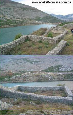
This mediaeval fortress was built on a low limestone prominence (below elevation 325, where there is now a quarry), 2 km. upstream from Trebinje, on the right bank of the Trebišnjica. The Nikšić road passes to the north and east of the site. The fortress dominated the region and was of major strategic importance in safeguarding the very important road linking Dubrovnik with the hinterland.
Access to the fortress is much easier from the Trebinje to Nikšić road than from the south, along the banks of the Trebišnjica, which are overhung by limestone cliffs.
Historical data
Mičevac is a prehistoric hill-fort and mediaeval fortress. There is no particular data on Roman settlement, but two highly corroded coins are Roman, and in the recollection of Dr. Ivo Bojanovski, there are indications that there was a small Roman settlement there (Odavić, 1983., 213). It belonged to the Trebinje region, sensu strictu. It is not known when the fort was built. Legend recounts that one Duke (Vojvod) Mičeta built it. Vego quotes Luccaria to the effect that in the eleventh century there was a battle near Mičevac (rocca di Miciaz) between the Hum Prince (Knez) Ljutovid and the Zetski Prince Dobroslav (P. Luccari, Copioso ristretto, Ragusa, 1790,19, and Šišić, Ljetopis popa Dukljanina, 384—354). Sources do not mention whether it was in the hands of the Pavlović's, who held Trebinje for some time, although this seems likely (Korać, 191966., 194). Surviving sources date from the rule of the regional lord Stjepan Vukčić Kosača, who held Trebinje from 1438, and it is assumed that Mičevac, too, came under the rule of Duke (Herceg) Stjepan that same year. It remained in his hands for a long period and is thus often called Hercegov grad or Duke's fort. During this period Mičevac had an important role and was a militarily strategic site. It also controlled the road, and was the headquarters of the customs officer. Suburbs developed in the nearby Varošište. Three charters issued in the mid fifteenth century refer to Mičevac as a «castelo» (1444), a «castrum» (1448) and a «civitate» (1454).
The people of Dubrovnik rebelled against the Herceg customs officers, but to no avail. During the war between Dubrovnik and Herceg Stjepan (1451-1454), the people of Dubrovnik told King Tomaš, their ally against Herceg, “that they would purchase or conquer” the forts of Mičevac, Trebinje and Vrm and another four forts in the Herceg's possession. The Herceg's customs officer in Mičevac is referred to up to 1456, and there is also reference to the commander of the fort «chote» Radosav Dup.
Sultan Muhamed II demanded that Herceg Stjepan cede Mičevac, Čačvina (near Omiš) and Klobuk in the nearby parish of Vrm to him. Following a falling-out between Herceg Stjepan and his son Vladislav, Mičevac came under the rule of Duke Vladislav. During the final battles, in 1466, the people of Dubrovnik provided some help to the defenders of Mičevac. That same year Trebinje came under Ottoman rule, and Mičevac probably fell into their hands too at that time. The fort lost its importance during the Ottoman period and there is no further reference to it in historical sources (Kreševljaković-Kapidžić, 1954, Vego, 1957, 74).
Legal status to date
Pursuant to the provisions of the law, and by ruling of the Institute for the Protection of Cultural Monuments of SR BiH, no. 917/51 dated 24 October 1951 in Sarajevo, the fortress of Mičevac in Gorica, Trebinje, was placed under state protection.
On 18 April 1962 it was entered in the Register of Cultural Monuments, by Ruling of the Institute for the Protection of Cultural Monuments of SRBiH no. 02-836-3.
The mediaeval fort of Mičevac in Trebinje is registered and categorized in the urban plan of the Republic of Bosnia and Herzegovina to 2002 as a Category III monument.
The mediaeval fort of Mičevac is listed on the Provisional List of National Monuments as no. 709.
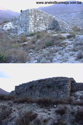
2. Description of the site
The fort lies on a karst plateau of which the southern flank drops steeply to the Trebišnjica at a point where the river bends. The entire surroundings can be surveyed from this relatively low hillock. The main mediaeval Dubrovnik-Trebinje-Nikšić road ran to the north and east of the fort, which was why Herceg Stjepan established a customs house there.
The ramparts of the town enclose an irregular rectangle with an area of about 1300 m2. The dimensions of the fortified town are 58 m in length (east to west), with a maximum width at the centre of 23 m, narrowing to 16 m at the eastern end and about 10 m at the western end. Its size is appropriate to the site on which it was built and its function. The main defence points were along the north wall, some 59 m long and 1.7-1.4 m thick. Here stand four massive towers built directly out of the ramparts. The placing of these towers is fairly regular. The most massive is the central tower no. 3, with two smaller quadrangular tower to the east and the west (towers 2 and 4). Another massive semicircular tower stands on the north-eastern corner. The northern rampart forms the south wall of all these towers other than tower no. 3.
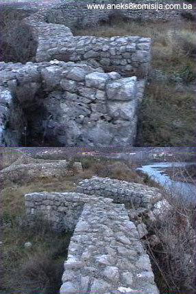
Tower no. 1 is on the north-eastern corner of the fortress. It is the most prominent tower, semicircular in plan, with walls 2.1 m thick, reducing to 1.6 m where it abuts onto the eastern ramparts. The diameter of the tower, including the wall, is 8 m. The interior dimensions of the tower are 5.8 m long and about 4.5m wide. The interior of the tower has been filled with stone.
Tower no. 2 is about 6.5m to the west of tower 1, and is rectangular in plan, with exterior dimensions of 6 x 3.5 m, and interior of 3.5 x 2 m. The thickness of the east and north walls is 1.5 m, and of the west wall is 1 m. It has not been filled with stone. The entrance to the tower is no longer visible, but must have been in the northern ramparts.
Between towers no. 2 and 3, part of the northern ramparts, to a length of about 4 m, is in ruins. Tower no. 3 is on the most prominent part of the northern ramparts, roughly in the centre. It is the strongest and most salient point of the fortress, and was the main and most massive tower. It is trapezoid in plan. It is almost level with the ramparts to the west, whereas it juts out to the east. The exterior dimensions of the tower are: west wall 8.8 m long and 2.2 m thick; east and west walls 8 m long and 2 m thick; south wall 6.6 m long and 1 m thick. Internally the tower is relatively small, 3.5 (3) m x 4 m, and has been filled with stone, like tower no. 1.
Tower no. 4 stands on the western half of the northern ramparts. It is rectangular in outline, with external dimensions of 5.2 x 3.5 m and internal dimensions of 3 x 2.3 m. The walls are 1.2 m thick.
Beneath the towers were subterraneous cistern-like spaces, but it is not known whether they were used as cisterns or served as dungeons. It was believed that they held treasure, and two were dug out, but nothing was found there.
In the western part of the fortress, alongside the main ramparts, is projecting tower no. 5, an irregular rectangle in outside, with angled walls, reminiscent of a bastion. Its external dimensions are 10 (9.3) x 6 m, and the internal are 6.9 m x 4.3 m. It is not known where the entrance was.
An enclosed space abuts onto its south wall, forming a small enclosure shielding the main entrance into the fort. It occupies the western part of the south ramparts. The south wall of the enclosure is 13.7 m long and 1.7 m thick, as is the north wall. Here there is an entrance, 1.4 m wide. Almost opposite this, in the south wall of the fort, is the main entrance to the fortress. It was probably inside a passage, of which the low lateral walls survive. The passage is 1.4 to 2 m wide, and to the east of the passage is part of the wall, 5.5 m long, that shielded the enclosure or barbican. The south-eastern part of this is enclosed by natural rock. It is possible that there was a wall against the rock, which has since collapsed.
The southern ramparts are somewhat thinner than the northern, with a thickness of 0.95 to 1 m. There was much less risk of the fort being breached from this side because of the steep cliffs over the Trebišnjica. The wall is somewhat broken down in several places, as is the north wall. A building known as the palace abuts onto the eastern half of the interior wall of the fort, measuring 14 x 7.2 m, with walls 0.95 m thick. The entrance to the building is in the north wall, and is 1.8 m wide, with two 1.2 m wide steps below. A semicircular structure is built into the south-west corner of the palace; its use is not known, but it might have been the pedestal for an oven. There is something similar in the building in Blagaj on the Buna, also a Herceg fort, identified as the town palace. The south-eastern corner of the fort has also had a wall built on, 19.5 m long and 1.15 m thick. Between this and the north-eastern corner of the palace is a passage, 1 m wide. This was probably part of the palace, but this cannot be determined now. Other than two summary reports, the findings of the excavations in Mičevac have not been published, and the so-called conditions of the findings are unknown.
During the course of archaeological excavations, many items more of a luxury than an everyday nature were found. In addition to some shards of late mediaeval Slav pottery, a surprising number of pieces of maiolica (imported from Italy) and of glass (imported from Italy and Germany) were found. Among the luxury archaeological items found were two small heart-shaped bronze items the use of which it is hard to ascertain. More luxury items than weapons were found in the fort. The only iron arms found were two arrows, in addition to which several stone cannonballs and pebbles used as slingshots were found.
In the site excavated four coins were also found, two bronze and two silver. The bronze coins are severely corroded and their inscriptions cannot be deciphered, but it is assumed that they are Roman. The two silver coins are very well preserved, particularly the larger, on which is a clearly recognizable image of St. Vlach (Odavić, Tribunia 1983, p. 215). All the movable archaeological items are in the Museum of Herzegovina in Trebinje.
The ground plan of the fort, and the shape of its towers and bastion, suggest that the fort that survives today dates from the time of Herceg Stjepan, concerning which there are also the greatest number of historical sources, that is around the mid fifteenth century. The movable archaeological material is also evidence of this.
3. Excavations and works of conservation and restoration
In 1983-84 the Republic Institute for the Protection of Cultural Monuments of Bosnia and Herzegovina and the Trebinje Hydroelectric power station conducted archaeological excavations in the fort of Mičevac. On this occasion all the walls were dug out so that the archaeological complex of the mediaeval fort of Mičevac could be seen.
In 1984-86, as part of the same project, the conservation of the cornice of the walls and towers was carried out. This was done using cement plaster, with the entire upper part of the ramparts coated with cement plaster to prevent water penetrating into the walls and causing further deterioration and collapse.
4. Current condition of the site
On site inspection ascertained the following:
§ The structure of the mediaeval fort of Mičevac is in a ruinous state.
§ The fort is at risk from the operations of the nearby quarry, some 500 m away as the crow flies.
III - CONCLUSION
Applying the Criteria for the adoption of a decision on proclaiming an item of property a national monument, adopted at the fourth session of the Commission to Preserve National Monuments (3 to 9 September 2002), relating to the immovable and movable heritage of Bosnia and Herzegovina, the Commission has enacted the Decision cited above.
A. Time frame
B. Historical value
F. Townscape/landscape value
G. Authenticity
G. I. Form and design
G. V. Location and setting
G. VI. Spirit and feeling
H. Uniqueness/rarity
H.I. Unique or rare example of a certain type or style
The following documents form an integral part of this Decision:
- copy of cadastral plan;
- copy of land registry entry and proof of title
- photodocumentation;
- drawings
Bibliography
Korać J. Vojislav, Trebinje, Istorijski pregled i period do dolaska Turaka. (Historical overview and period to the arrival of the Turks) National Museum of Trebinje, Trebinje 1966.
Kreševljaković H. and Kapidžić H., Stari hercegovački gradovi (Old Forts of Herzegovina) Naše starine II, Republic Institute for the Protection of the Cultural Heritage of BiH, Sarajevo, 1954, 9-21.
Odavić, Đorđo, Predhodni izvještaj sa arheološkog iskopavanja na srednjovjekovnom gradu Mičevcu. (Preliminary report on the archaeological excavations of the mediaeval fort of Mičevac) Tribunia 7, National Museum of Trebinje, Trebinje 1983., 213-215.
Tošić, Đuro, Trebinjska oblast u srednjem vijeku (Trebinje district in the Middle Ages), Historical Institute of the Serbian Academy of Science and the Arts, Belgrade, 1998.
Vego, Marko, Naselja srednjovjekovne bosanske države (Settlements of the mediaeval Bosnian state) Svjetlost, Sarajevo 1957.
|