Status of monument -> National monument
Pursuant to Article V para. 4 Annex 8 of the General Framework Agreement for Peace in Bosnia and Herzegovina and Article 39 para. 1 of the Rules of Procedure of the Commission to Preserve National Monuments, at a session held from 6 to 12 May 2003 the Commission adopted a
D E C I S I O N
I
The architectural ensemble of the fort of Ključ in Ključ is hereby designated as a national monument of Bosnia and Herzegovina (hereinafter: the National Monument). The National Monument is on the site of cadastral plot 1/22, known as Breščica plot, cadastral municipality Ključ II, Ključ Municipality, Federation of Bosnia and Herzegovina.
The National Monument includes the mediaeval and the Ottoman fort of Ključ, Tabori («camps») and the Ljubica tower.
The provisions relating to protection and rehabilitation measures set forth by the Law on the Implementation of the Decisions of the Commission to Preserve National Monuments, established pursuant to Annex 8 of the General Framework Agreement for Peace in Bosnia and Herzegovina (Official Gazette of the Federation of BiH nos. 2/02 and 27/02) shall apply to the National Monument specified in the preceding paragraph.
II
The Government of the Federation of Bosnia and Herzegovina (hereinafter: the Government of the Federation) shall be responsible for ensuring and providing the legal, scientific, technical, administrative and financial measures necessary to protect, conserve, display and rehabilitate the National Monument.
The Government of the Federation shall be responsible for providing the resources to draw up and implement the necessary technical documentation for the rehabilitation of the National Monument.
The Commission to Preserve National Monuments of Bosnia and Herzegovina (hereinafter: the Commission) shall determine the technical requirements and secure the funds for preparing and setting up signboards with the basic data on the monument and the Decision to proclaim the property a National Monument.
III
Ÿ In the protected area as defined in Clause 1 of this Decision only research works and works of conservation, structural renovation and restoration, including works designed to display the monument, conforming to technical documentation drawn up to the conditions set by the heritage protection authority of the Federation of Bosnia and Herzegovina (hereinafter: the heritage protection authority) shall be permitted,
Ÿ The construction of all buildings and the erection of temporary or permanent structures not solely intended to protect and display the monument is prohibited on the site of the monument,
Ÿ Felling trees and other operations that could have the effect of altering the area are prohibited,
Ÿ The area of the monument shall be open to the public and may be used for educational and cultural purposes,
Ÿ The following works shall be carried out for the purpose of effecting immediate protection measures:
o Clearing the walls of self-sown vegetation that is a danger to the structure of the walls
o Works to conserve the existing condition.
Protection Zone II covers the area from Turbe to Tabori and at least 100 m. from Tabori to the east, the area between Tabori and the old fort of Ključ, and the area below the southern ramparts of the fort of Ključ to below the Podgrađe locality. In this zone no new construction is permitted, including alterations to the landscape. The restoration, reconstruction and adaptation of existing buildings forming an integral part of the broader protected spatial ensemble is permitted. When rehabilitating existing buildings a maximum of two storeys (ground floor and one upper floor) with a maximum height to the roof cornice of 6.5 m. shall be permitted, and maximum horizontal dimensions of 12 x 10 m.
IV
All executive and area development planning acts not in accordance with the provisions of this Decision are to be revoked.
V
Everyone, and in particular the competent authorities of the Federation of Bosnia and Herzegovina, the Canton, and urban and municipal authorities, shall refrain from any action that might damage the National Monument specified in Clause I of this Decision or jeopardize the preservation and rehabilitation thereof.
VI
The Government of the Federation, the Federal Ministry responsible for town planning, the Federation heritage protection authority, and the Municipal Authorities in charge of urban planning and land registry affairs, shall be notified of this Decision in order to carry out the measures stipulated in Articles II, III and IV of this Decision, and the Authorized Municipal Court shall be notified for the purposes of registration in the Land Register.
VII
The elucidation and accompanying documentation form an integral part of this Decision, which may be viewed by interested parties on the premises or by accessing the website of the Commission (http://www.anek8komisija.com.ba)
VIII
Pursuant to Art. V para 4 Annex 8 of the General Framework Agreement for Peace in Bosnia and Herzegovina, decisions of the Commission are final.
IX
This Decision shall enter into force on the date of its adoption and shall be published in the Official Gazette of BiH and the Official Gazette of the Federation of BiH.
This Decision has been adopted by the following members of the Commission: Zeynep Ahunbay, Amra Hadžimuhamedović, Dubravko Lovrenović, Ljiljana Ševo and Tina Wik.
Chairman of the Commission
Amra Hadžimuhamedović
No: 06-6-741/03-3
XX. 05. 2003
Sarajevo
E l u c i d a t i o n
I – INTRODUCTION
Pursuant to Article 2, paragraph 1 of the Law on the Implementation of the Decisions of the Commission to Preserve National Monuments, established pursuant to Annex 8 of the General Framework Agreement for Peace in Bosnia and Herzegovina, a “National Monument” is an item of public property proclaimed by the Commission to Preserve National Monuments (hereinafter referred to as the Commission) to be a National Monument pursuant to Articles V and VI of Annex 8 of the General Framework Agreement for Peace in Bosnia and Herzegovina (hereinafter referred to as Annex 8) and as property entered on the Provisional List of National Monuments of Bosnia and Herzegovina (Official Gazette of BiH no. 33/02) until the Commission reaches a final decision on its status, as to which there is no time limit and regardless of whether a petition for the property in question has been submitted or not.
At a session held on 1 to 2 July 1999 the Commission issued a Decision to add the architectural ensemble of the mediaeval fort of Ključ in Ključ to the Provisional List of National Monuments of Bosnia and Herzegovina, under the heading Ruins of the old town and fort of Stjepan Tomašević in Ključ numbered as 300.
Pursuant to the provisions of the law, the Commission proceeded to carry out the procedure for reaching a final decision to designate the Property as a National Monument, pursuant to Article V of Annex 8 and Article 35 of the Rules of Procedure of the Commission to Preserve National Monuments.
II – PROCEDURE PRIOR TO DECISION
In the procedure preceding the adoption of a final decision to proclaim the property a national monument, the following documentation was inspected:
Ÿ Documentation on the location and current owner and user of the property (copy of cadastral plan and copy of land registry entry)
Ÿ Data on the current condition and use of the property, including a description and photographs, data of war damage if any, data on restoration or other works on the property if any, etc.
Ÿ Historical, architectural and other documentary material on the property, as set out in the bibliography forming part of this Decision.
The findings based on the review of the above documentation and the condition of the site are as follows:
1. Data on the site
Location
The area of Ključ and Pecka is in the upper Sana, compressed between Mulež to the north, Dimitor to the east, Montenegro to the south, and Šiša (Srnetica) and Grmeč to the west. The settlement of Ključ lies in a gentle oasis surrounded by moutains, alongside the left bank of the Sana, where it enters the large Sklop canyon that is part of the area of Sanski Most. Ključ is is distinguished by its favourable communications position at the junction of two ancient main roads (Salona – Siscia via the Sana valley, and Salona – Servitium via Pecka), routes that were also used in the middle ages. The only road that now runs through Ključ is the one leading to Petrovačko polje and Sanski Most.
The mediaeval fort of Ključ is on c.p. 1/22, c.m. Ključ II, Ključ Municipality.
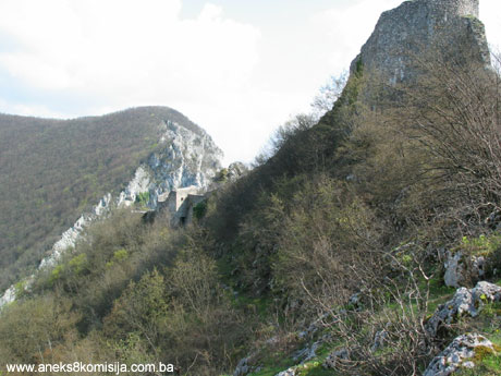
The fort is above the left bank of the Sana, above the modern settlement of Ključ, at an altitude of 521 m. at the point where the Sana enters a gorge between Breščica (528 m) and Ljubinska mountain (656 m) in a position with outstandingly good natural defences. Here fortifications were built in antique times, and again in the middle ages.
Historical information
During archaeological excavations and reconnaissance on the fort, antique finds were uncovered in the area of the palace and around the Ljubica fort. Bojanovski’s exacavations confirmed the survey by Radimski in the late nineteenth century. A strong Roman fort was built on the site of the fort above Ključ, the date of which cannot be accurately determined. The major crossing over the Sana was kept under observation from this fortress. Traces of a smaller Roman fort also lie on the plateau by the Ljubica tower, and on the plateau beneath this are the remains of some masonry structure dating from antique times.
Here the unified territorial and political entity of Sanica župa (county) was formed in the middle ages. The area is characterized by its forests, land and good pastures.
One can only hazard a guess at the date of origins of the first fortifications of the mediaeval town of Ključ. At first Ključ was the county town of the mediaeval župa of Sanica. It was one of the oldest towns; Bojanovski hypothesizes that it was founded during the thirteenth century (Bojanovski, 1973, 105 ; Truhelka, 1904, 61).
The earliest explicit reference to the town of Ključ dates from 1322, in a charter of ban Stjepan II Kotromanić bestowing Banica župa (Mrenska župa) and Vrbanja, and the towns in them of Ključ and Kotor, on Vukosav Hrvatinić, Vukosav, son of Prince Hrvatin, is referred to in 1325 as the prince of Ključ. From then on Ključ was a Hrvatinić possession. Since the sons of Hrvatin Stjepanić were vassals of ban Stjepan II Kotromanić, the Banica župa and the town of Ključ became part of the Bosnian state. In about 1325 Hrvatin, the father of Vukosav Hrvatinić, had the nickname “Ključki”, meaning that the town existed around the end of the thirteenth century.
King Tomaš confirmed the possession of Ključ by Ivaniš Dragišić and his sons by a charter issued in Vranduk in 1446. Although Ključ had already been known for 120 years, it was only in this charter by King Tomaša that there is reference to the varoš or town of “Pod Ključ”. Both Ključ and the entire area of the Lower Regions acquired importance when as a result of the Ottoman onslaught the capital of the state was moved to the western regions. The presence of the King and his retinue boosted the trade and economic development of the region.
In 1463 the last Bosnian king, Stjepan Tomašević, tried to find refuge in Ključ, but was captured and imprisoned.
From the seizure of Ključ in 1463 to 1878 the town formed part of the Ottoman sultanate. There was a permanent garrison in the fort under a dizdar until 1838. In the late seventeenth century there was also a kapetan headquartered in Ključ.
One Hadži Osman built a mosque in the town, in which there were eight officials in 1775.
During military operations, a battle was waged with the Austro-Hungarian army below the town in 1878.
Legal status to date
In the procedure preceding the adoption of a final decision on designation of the national monument, acts on the protection of the property were inspected and the following was ascertained:
Pursuant to the law, by Ruling of the Institute for the Protection of Cultural Monuments of SR BiH no. 150/51 dated 1 February 1951 in Sarajevo, the mediaeval fort of Ključ was placed under state protection.
By Ruling of the Institute for the Protection of Cultural Monuments of SR BiH no. 249 it was entered in the register of immovable cultural monuments.
Pursuant to the law, by Ruling of the Institute for the Protection of Cultural Monuments of SR BiH no. 151/51 dated 1 February 1951 in Sarajevo, the Turkish fort of Ključ in Ključ was placed under state protection (Tabori).
By Ruling of the Institute for the Protection of Cultural Monuments of SR BiH no. 250 it was entered in the register of immovable cultural monuments.
The Regional Plan for the Republic of Bosnia and Herzegovina to 2002 listed it as a Category II monument.
The architectural ensemble of the mediaeval fort of Ključ in Ključ is on the Provisional List of National Monuments as Ruins of the old town and fort of Stjepan Tomašević in Ključ numbered as 300
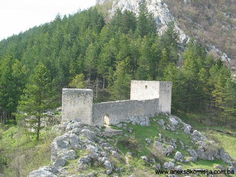
2. Description of the site
The fort of Ključ is set on heights and was built at the time of cold steel, prior to the use of firearms, but over time certain parts of the fort or individual structures within it were adapted for firearms use.
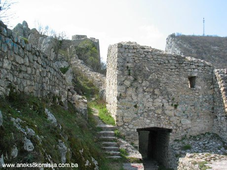
The ruins of the fort of Ključ consist of three separate complexes forming an organic whole, but not surrounded by a single perimeter wall. The basic features of the mediaeval fort itself are its elongated ground plan and the relatively small area of the defences but a somewhat complex system of fortifications.
The fort in the narrow sense is high above the Sana, and it was only this part that was surrounded as a whole by ramparts. Within this complex is the heart of the mediaeval fortress with kind of “subfort” below, “Podgrađe”, some 50 m below the gate tower, which was also surrounded by walls, but these have long since collapsed. On a level area below the north ramparts, four test digs found only antique material, splavljen from the fort. This area beneath the fort is overgrown with woods.
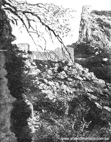
The Ljubica tower, which is free-standing, is on the westernmost and highest point of the rocky outcrop above the fort and tabori.
The tabori are on a ridge below the fort. They are basically mediaeval, but in their current shape date from the Ottoman period.
The fort is the oldest, and is the mediaeval town of Ključ. Over time certain parts of the fort or individual structures within it were adapted for firearms use. The fort consists of several structures built on bumpy, rocky ground on several ridges that fall away steeply to the south, towards the valley in which the present day settlement of Ključ lies. To the south it is defended by the cliffs of a deep ravine, and to the north by the high ramparts of the defences surrounding the entire complex of the mediaeval fortress. The ground plan of the fort is fully adapted to the long, narrow site.
It lies west-east, extending over a length of about 125 m., while the interior width varies, according to the terrain available for building, from 5 to 13 metres. The area of the fort is some 850 m2. There are several ensembles within this area: running from west to east these are (Annex 5):
The guard or main tower is hexagonal (B), with an interior diametre of about 3 m. A square space (a dungeon or a cannon-ball store) is dug out within it. Its exact purpose is unknown, since there were no finds made there. Outside it is a rectangular antechamber (B1), measing 3.15 x 2.6 m with an original depth of 2.56 m, which was apparently filled in at the turn of the fifteenth to sixteenth century. This infill reinforced the north rampart of the fort. The original mediaeval thickness of the north rampart was 1.1 m, but with this reinforcement it increased to 2.1 m. At the same time as these works, the guard tower was reduced in height and its interior filled with mortar and stone to provide additional resistance to artillery fire. The access to the entry to the guard tower was cobbled.
A long (35 m.) and narrow (3-4 m.) bailey in the western part of the fort (B2) was entered from the antechamber of the guard tower. This served mainly to link the tower and the eastern part of the fort, where the main buildings were, the entrance to the fort (A), the eastern bailey, the palace (E, E1 and E2, F4), two water tanks (E3 and C1) and a mediaeval cannon nest on the eastern edge of the fort (G).
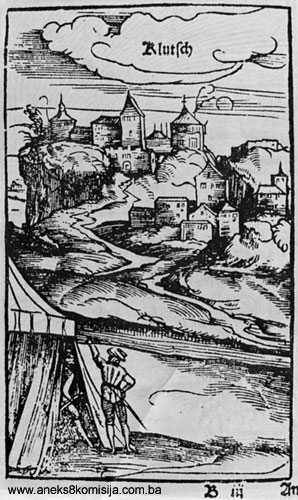
The entrance tower (A) was not built until the Ottoman period. In the engravings from Kuripešić’s travelogue it can be clearly seen that in the 1530s the entrance was still in the ramparts. The two-storey gate tower was probably built somewhat later in the same century (Bojanovski, 1973, 102). The gate tower had a vaulted entrance to the west. The traces of tiebeams are visible in the walls of the tower. West of the gate tower are the remains of the wall that in the shape of a barbican defended the original main entrance t the fort.
Opposite the main entrance the area designed on the plan as C, C1, C2 was excavated. Three artificial terraces were dug out there from a large rocky mass (the central ridge) which dominated the entrance to the fort, with very faint traces of walls 0.55 m. thick. According to Bojanovski, on area C there was some Roman structure, since it was here that during excavations a major concentration of antique brick and tile was found. In the middle ages there was a building at C and C1, the purpose of which is not known; C1 had an underground water cistern. A great deal of later mediaeval pottery was found here (Bojanovski, 1973, 103).
The palace building (E-F) was skilfully fitted in between the central and eastern ridges on the edge of the ravine. The palace had a rectangular ground plan and an area of 300m2, with several rooms. As well as the ground floor it also had one upper floor, as suggested by the remains of the north wall, which has survived to a height of 5.5 m. The palace complex was entered from the north through a wide, shallow portico measing 8 x 2 m (E1), to the east of which was a kitchen measuring 3 x 2.5 m (E2). Room (E) measured 5 x 3.5 m. and served as an armourer’s shop. The floor screed was of good quality quicklime mortar which, together with the remains of the upper parts of the walls and cistern, was the remains of some original fort from antique times. On the steep terrain in the southern part of the palace above the ravine was a cistern (E3) which collapsed as the result of tectonic disturbances, but on the floor a segment of the facing of the arch of the cistern’s upper opening was found. Room F was the most spacious part of the palace (9 x 6 m). Only the foundation walls of this survive. Throughout the palace there were many archaeological finds of movable items, late mediaeval kitchen pottery, maiolica, fragments of ovens and metal items (nails of various kinds up to 20 cm long, horseshoes, arrows) and stone and iron cannon balls of various calibres.
The eastern part of the fort, known as the Garden, lies above the Sana gorge. In premises G a cannon nest was dug out comprising a room 6 x 5 m. for the crew and a large cannon opening in the north rampart above it.
Beneath this was the “subfort” on the steep slope down to the river Sana. Here all that was found was antique material that was detritus from the fort.
The prominent free-standing Ljubica tower stands on a height adjacent to and north west of the fort, dominating the entire region of this part of the Sana valley. It was built as a flanking defence for the fort from enemy artillery by keeping the access to the fort under observation and preventing the enemy from taking up siege positions. It is circular in cross-section with a diameter of 6 m, and has two storeys. It probably dates from the fifteenth century (Bojanovski, 1973, 103).
The Tabori are about 150 m north-west of the gate tower of the old fort, on the first terrace to the north below the fort. They were built in the last stage of the mediaeval fortifications of Ključ and were minor fortifications of polygonal ground plan, erected along the access to the fort. Alongside the southern rampart of the tabori, mediaeval remains, premises and movable archaeological items, were found, evidence that this part too belonged to the defence complex of the mediaeval town of Ključ. The tabori are recognizable on the engravings from Kuripešić’s travelogue dating from the 1530s, but without towers.
In this part of the fortifications the Ottomans made major changes. The fortifications had a triangular ground plan, and three towers were built in the angles – two on the northern rampart and a third that was pulled down when the road was built about forty years ago. The construction of the towers and relatively low walls on the tabori was not very solid. The mediaeval remains of the premises along the south rampart were buried in the Ottoman period.
The north tower was larger, square in section, with the sides 7 m. long Between it and the smaller south tower was a wall some 20 m. long in which was the entrance to the tabori from the fort. The third tower no longer exists.
3. Research and conservation and restoration works
1969. Systematic archaeological research by the Institute for the Protection of Cultural Monuments of BiH on the fort and tabori. The purpose of the excavations was twofold: for research purposes, and as the background to the partial conservation and display of the ruins. The work was co-financed by Ključ municipality.
1973. Archaeological research by the Institute for the Protection of Cultural Monuments of BiH on the fort and tabori. Apart from a brief report that was lost with part of the documentation in the 1992-1995 war, the findings of these words have not been published. At the same time, for the purpose of the conservation and part restoration of the fort, a geodetic plan was drawn up. Along with the excavations in the fort and tabori, experts from the Institute for the Protection of Cultural Monuments of BiH carried out more comprehensive conservation and restoration works. The documentation is held by the Institute for the Protection of Cultural Monuments of the Federation of Bosnia and Herzegovina.
The movable archaeological material was handed over to the Museum of Bosanska krajina (now the Museum of Republika Srpska) in Banja Luka.
1980. Completion of excavation of cannon nest (G), works on the guard tower (B) and the area in front of it (its forecourt). Conservation was carried out in parallel with the archaeological works.
1981. Continuation of excavations of the palace (E, F), eastern area outside the guard tower (B) and “subfort” immediately below the north ramparts of the fort. Conservation was carried out in parallel with the archaeological works.
1986-1989. Conservation of the complex of the fort and tabori.
4. Current condition of the site
On site inspection ascertained the following:
The mediaeval fort of Ključ is in relatively good condition apart from some minor cracks and deterioration of the wall and invasions by weeds west of the gate tower. The other parts are fairly well preserved. Conservation was carried out using cement mortar. In certain areas, particularly the lintels over the doors and windows and on the upper parts of the cannon opening, there are heavy applications of this mortar.
III. CONCLUSION
Applying the Criteria for the adoption of a decision on proclaiming an item of property a national monument, adopted at the fourth session of the Commission to Preserve National Monuments (3 to 9 September 2002), the Commission has enacted the Decision cited above.
The Decision was based on the following criteria:
A. Time frame
B. Historical value
C. Artistic and aesthetic value
C.i. quality of workmanship
C.iv. composition
C.vi. structural value
F. Townscape/landscape value
F.ii. meaning in the landscape
G. Authenticity
G.i. form and design
G.ii. material and content
G.v. location and setting
H. Rarity and representativity
H.i. a unique or rare example of a specific type or style
I. Integrity (groups, sites, collections)
I.i. physical coherence
I.ii. homogeneity
I.iii. completeness
I.vi. unimpaired condition
The following documents form an integral part of this Decision:
- Photodocumentation;
- Drawings
The documentation annexed to the Decision is public and available for view by interested persons on written request to the Commission to Preserve National Monuments of Bosnia and Herzegovina.
Bibliography
During the procedure to designate the monument as a national monument of Bosnia and Herzegovina the following works were consulted:
Bojanovski, Ivo, Bosna i Hercegovina u antičko doba. (Bosnia and Herzegovina in Ancient Times) Academy of Sciences and the Arts of BiH, vol LXVI, Centre for Balkan Studies , vol 6, Sarajevo, 1988
Bojanovski, Ivo, Ključ na Sani, Ključ – srednjovjekovni grad. (Ključ on the Sana, mediaeval fort) Archaeological Survey 15, Federation of Archaeological Societies of Yugoslavia, Belgrade, 1973, 100–105
Bojanovski, Ivo, Ključ na Sani, Ključ – srednjovjekovni grad. (Ključ on the Sana, mediaeval fort) Archaeological Survey 23, Federation of Archaeological Societies of Yugoslavia, Belgrade 1982, 140–142.
Kovačević-Kojić, Desanka, Gradska naselja srednjovjekovne bosanske džave. (Urban Settlements of the Mediaeval Bosnian State) Sarajevo, Veselin Masleša, 1978
Kreševljaković, Hamdija, Prilozi povijesti bosanskih gradova pod turskom upravom (Contributions to the history of Bosnian forts under Turkish rule) Contributions to oriental philology and the history of the southern Slav peoples under Turkish rule, no.II, Sarajevo, 1952
Kreševljaković, Hamdija, Stari bosanski gradovi (Old Bosnian forts) Naše starine I, Institute for the Protection of Cultural Monuments of BiH, Sarajevo, 1954, 22
Popović, Marko, Srednjovjekovne tvrđave u Bosni i Hercegovini. (Mediaeval fortresses in BiH) Collected papers for the history of Bosnia and Herzegovina 1, Serbian Academy of Science and the Arts, Belgrade, 1995, 33-55
Popović, Marko, Vladarski i vlasteoski dvor u srednjovekovnoj Bosni. (Rulers’ and feudal lords’ court in mediaeval Bosnia) Collected papers for the history of Bosnia and Herzegovina 2, Serbian Academy of Science and the Arts, Belgrade, 1997., 1-33
Radimsky, Vaclav, O nekojim prehistoričkim i rimskim gragjevnim ostancima u području rijeke Sane u Bosni. (On some prehistoric and Roman building remains in the area of the river Sana in Bosnia) Journal of the National Museum III, Sarajevo, 1891, 431-445.
Truhelka, Ćiro, Naši gradovi.(Our towns) J. Studnička and co. publishers. Sarajevo, 1904.
Vego, Marko, Naselja srednjovjekovne bosanske države. (Settlements of the mediaeval Bosnian State) Svjetlost Sarajevo 1957, 105
|