Status of monument -> National monument
Pursuant to Article V para. 4 Annex 8 of the General Framework Agreement for Peace in Bosnia and Herzegovina and Article 39 para. 1 of the Rules of Procedure of the Commission to Preserve National Monuments, at a session held from 6 to 12 May 2003 the Commission adopted a
D E C I S I O N
I
The architectural ensemble of the mediaeval fort of Soko in Sokol, Gračanica, is hereby designated as a national monument of Bosnia and Herzegovina (hereinafter: the National Monument).
The National Monument is on a site comprising cadastral plot 165 (old survey) new survey 2842, cadastral municipality Soko, land registry entry 368, Gračanica Municipality, Federation of Bosnia and Herzegovina.
The provisions relating to protection and rehabilitation measures set forth by the Law on the Implementation of the Decisions of the Commission to Preserve National Monuments, established pursuant to Annex 8 of the General Framework Agreement for Peace in Bosnia and Herzegovina (Official Gazette of the Federation of BiH nos. 2/02 and 27/02) shall apply to the National Monument specified in the preceding paragraph.
II
The Government of the Federation of Bosnia and Herzegovina (hereinafter: the Government of the Federation) shall be responsible for ensuring and providing the legal, scientific, technical, administrative and financial measures necessary to protect, conserve, display and rehabilitate the National Monument.
The Government of the Federation shall be responsible for providing the resources to draw up and implement the necessary technical documentation for the rehabilitation of the National Monument.
The Commission to Preserve National Monuments of Bosnia and Herzegovina (hereinafter: the Commission) shall determine the technical requirements and secure the funds for preparing and setting up signboards with the basic data on the monument and the Decision to proclaim the property a National Monument.
III
Ÿ The only works permitted on the protected site stipulated in Clause 1 of this Decision are research works and works of conservation, structural renovation and restoration, including works designed to display the monument, according to technical documentation drawn up to the terms and conditions set by the heritage protection authority of the Federation of Bosnia and Herzegovina (hereinafter: the heritage protection authority);
Ÿ All construction or erection of temporary or permanent structures not intended solely for the protection and display of the monument is prohibited;
Ÿ The site of the monument shall be open and accessible to the general public and may be used for educational and cultural purposes;
Ÿ The following measures shall in particular be enforced:
o clearing the walls of vegetation that is a danger to the structure of the building;
o conservation of the existing condition.
For the purpose of the preservation of the National Monument the following Protection Zones are hereby defined:
Protection Zone I covers c.p. 2841, 2842, 2817, 2818, 2827, 2828, 2829, 2830, 2831, 2832, 2834, 2835, 2839, 2843, 2844.
In Protection Zone I no new construction, erection of temporary structures or other works that could have the effect of altering the environs is permitted.
Access to the monument must be provided by means of an access road. All structures of a temporary nature shall be removed from the area of the access road to the monument. Existing residential units may not be built on to so as to exceed a height of 6.5m to the roof cornice.
Protection Zone II covers c.p: 2289/4, 2360, 2362-2365, 2772/1, 2774, 2777, 2778, 2778/1, 2779, 2780, 2780/3, 2781, 2782/1, 2782/2, 2782/3, 2782/4, 2783/2, 2784-2788, 2789, 2789/1, 2789/2, 2790-2792, 2792/2, 2793, 2794, 2798 južni dio puta, 2799, 2802, 2814-1816, 2819, 2819/1, 2819/2, 2820, 2821/1, 2821/2, 2822-2825,2826/1, 2826/2, 2839, 2840, 2862, 2865, 3196, 3204, 3220.
In Protection Zone II the restoration, reconstruction and adaptation of existing buildings is permitted provided that they do not exceed two storeys (ground and one upper floor) with a maximum height of 6.5 m. to the roof cornice, maximum horizontal dimensions of 12 x 10 m., with hipped roofs with a maximum pitch of 45 degrees. Details regional planning documents and town planning and technical conditions for the construction of new buildings must have the approval of the heritage protection authority of the Federation of Bosnia and Herzegovina. The construction of industrial facilities, major infrastructure, or potential polluters as defined by law, is prohibited.
IV
All executive and area development planning acts not in accordance with the provisions of this Decision are to be revoked.
V
Everyone, and in particular the competent authorities of the Federation of Bosnia and Herzegovina, the Canton, and urban and municipal authorities, shall refrain from any action that might damage the National Monument specified in Clause I of this Decision or jeopardize the preservation and rehabilitation thereof.
VI
The Government of the Federation, the Federal Ministry responsible for town planning, the Federation heritage protection authority, and the Municipal Authorities in charge of urban planning and land registry affairs, shall be notified of this Decision in order to carry out the measures stipulated in Articles II, III and IV of this Decision, and the Authorized Municipal Court shall be notified for the purposes of registration in the Land Register.
VII
The elucidation and accompanying documentation form an integral part of this Decision, which may be viewed by interested parties on the premises or by accessing the website of the Commission (http://www.anek8komisija.com.ba)
VIII
Pursuant to Art. V para 4 Annex 8 of the General Framework Agreement for Peace in Bosnia and Herzegovina, decisions of the Commission are final.
IX
This Decision shall enter into force on the date of its adoption and shall be published in the Official Gazette of BiH and the Official Gazette of the Federation of BiH.
This Decision has been adopted by the following members of the Commission: Zeynep Ahunbay, Amra Hadžimuhamedović, Dubravko Lovrenović, Ljiljana Ševo and Tina Wik.
Chairman of the Commission
Amra Hadžimuhamedović
No: 06-6-89/03-1
May 2003
Sarajevo
E l u c i d a t i o n
I – INTRODUCTION
Pursuant to Article 2, paragraph 1 of the Law on the Implementation of the Decisions of the Commission to Preserve National Monuments, established pursuant to Annex 8 of the General Framework Agreement for Peace in Bosnia and Herzegovina, a “National Monument” is an item of public property proclaimed by the Commission to Preserve National Monuments (hereinafter referred to as the Commission) to be a National Monument pursuant to Articles V and VI of Annex 8 of the General Framework Agreement for Peace in Bosnia and Herzegovina (hereinafter referred to as Annex 8) and as property entered on the Provisional List of National Monuments of Bosnia and Herzegovina (Official Gazette of BiH no. 33/02) until the Commission reaches a final decision on its status, as to which there is no time limit and regardless of whether a petition for the property in question has been submitted or not.
At a session held on 1 July 1999 the Commission issued a Decision to add the Soko Fort in Gračanica to the Provisional List of National Monuments of Bosnia and Herzegovina, numbered as 258.
Pursuant to the provisions of the law, the Commission proceeded to carry out the procedure for reaching a final decision to designate the Property as a National Monument, pursuant to Article V of Annex 8 and Article 35 of the Rules of Procedure of the Commission to Preserve National Monuments.
II – PROCEDURE PRIOR TO DECISION
In the procedure preceding the adoption of a final decision to proclaim the property a national monument, the following documentation was inspected:
Ÿ Documentation on the location and current owner and user of the property (copy of cadastral plan and copy of land registry entry)
Ÿ Data on the current condition and use of the property, including a description and photographs, data of war damage if any, data on restoration or other works on the property if any, etc.
Ÿ The current condition of the property
Ÿ Historical, architectural and other documentary material on the property,
1. Data on the site
Location
The mediaeval fort of Soko is on c.p. no. 2842, c.m. Soko; land registry no. 358; and is state-owned.
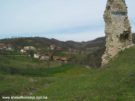
The fort is in the village of Soko some 5 km north-east of Gračanica, close by the Gračanica-Gradačac road. On slopes descending to the source of the river Sokoluša, in the centre of a natural basin surrounded by the southern promontories of Trebava, is a limestone outcrop some 40 m high on which the Soko fort was built. The village of Soko is one of the oldest settlements in Gračanica municipality, thanks to its favourable natural conditions (a hill village with pastures, forests and water).
Historical information
Historical data on the fort of Soko, which was in the mediaeval župa or county of Usora, are few, but data from the early Ottoman period confirm that the fort played an important part in both periods.
There are two different data about the earliest reference to Soko fort. Both are situated in the first half of the fifteenth century and linked with Prince Radivoj Ostojić, son of the Bosnian king Ostoja and brother of the Bosnian king Tomaš. One group of authors say that the earliest reference to the fort in historical sources dates from 1429 (Jalimam, 2001, 65; Handžić, 2001, 68; Vego, 1957, 105), while another group sets the date as 1449 (Kreševljaković, 1953, 22; Basler, 1972, 58).
Jalimam notes that the fortress of Soko is referred to by that name in a marriage settlement dated 2 June 1429 between Radivoj Ostojić and his father-in-law Nikola from Velika, whose daughter Katarina Radivoj married. Under the terms of the settlement, Radivoj bestowed on his wife’s parents half of Soko and all his holdings in mediaeval Bosnia and Slavonia. The assumption is that since Radivoj thus became part of the Magyar society of that region he was spared Magyar marauding campaigns (Jalimam, 2001, 66). Other authors cite the same date but place the marriage settlement in 1449 (Handžić, 2001, 68; Kreševljaković, 1953, 22; Basler, 1972, 58, taking his data from Kreševljaković). In the middle ages the Soko fort, together with Doboj, Srebrenik and Teočak, was on the southern line of Bosnian border fortresses marching with Hungary. The northern line was formed by Dobor, Gradačac and Koraj.
The Srebrenik banovina fell under Ottoman rule, according to one group of authors, in 1512, and it was probably then that Sokograd (Soko fort) was occupied (Kreševljaković, 1953, 22, taken from Klajić), while Vego says the fort was seized in 1520 (Vego, 1957, 105). With the fall of Srebrenik, the entire region between the lower courses of the Bosna and Drina, Spreča and Sava, where there were twelve fortified towns, became part of the Ottoman Empire. According to Hungarian sources, Soko was burned by its Magyar garrison. The area was “no man’s land” for a long time, until 1426, when following the battle of Mohács, the Ottomans were able to establish firm governance there. Until that time the garrisons were ulufedžija (day-wage frontier guards) without permanent timars allocated landholdings from the revenues of which the members of the garrisons were maintained), and are not referred to in the records. The first census defter with timars entered with the name of members of the Soko garrison dates from as late as 1528. According to a spahi census defter dating from 1533, that year the garrison of Soko fort acquired permanent timars. In a defter of the Zvornik sanjak dating from 1528, the settled Vlachs in the varoš of Soko fort are also listed. Although it was recorded that in the mid sixteenth century the Ottomans maintained a small garrison of 19 in Soko fort, they did not abandon it until 1840. In the sixteenth century the region belonged to the Zvornik sanjak, and upon formation of the kapetanijas it became part of the Srebrenik kapetanija. It was turned into a military fortress run by a dizdar. Over the next 150 years it had no strategic importance, right up to the time of the Vienna war (1683-1699).
There are few details from the eighteenth century. Some data has survived from 1716 on, when the dizdar of the fort was Hasanaga. At that time Soko also had an artillery aga. In the 1770s, the Gradačac kapetan, Mehmed, gave his assent to the fort being repaired. It is also noted that in 1833 the fort had seven cannon and that in 1838 essential minor repairs were not carried out. It was abandoned in 1840 (Kreševljaković, 1952, 168).
Legal status to date
In the procedure preceding the adoption of a final decision on designation, acts on the protection of the property were inspected and the following ascertained:
Pursuant to the law, and by Ruling of the Institute for the Protection of Cultural Monuments of SR BiH no. 191/51 dated 18 April 1962 in Sarajevo, the Soko fortress in Gračanica was placed under state protection.
By Ruling of the Institute for the Protection of Cultural Monuments of SR BiH no. 02-876-3 dated 18 April 1962 it was entered in the Register of immovable cultural monuments.
The Regional Plan for RBiH to 2002 listed the mediaeval fort of Soko in Gračanica as a Category III monument.
The mediaeval fort of Soko is on the Provisional List of National Monuments under serial no. 258.
2. Description of the monument
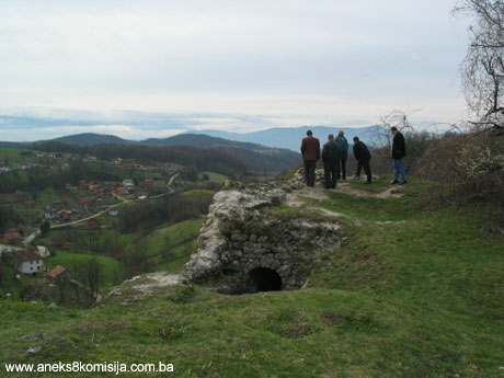
The fort of Soko was built on the summit of a stone outcrop rising some 40 metres above the surrounding terrain. The ramparts of the fort enclosed a single oval space with an area of some 650m2. The size of the fort was adapted to the lay and nature of the terrain as well as the function of defence. The long axis is oriented north-east/south-west and is 37 m. long; the cross-axis is 18 m. wide. To the north-east the wall ends in an oval, while in the south-west, by a major break in the outer ramparts, a trapezoid tower was built. On the south-east perimeter ramparts are two projecting semicircular towers with a diameter of 3 m over an inaccessible slope and serving solely for look-out purposes to guard the entrance to the fort, which was in the north-west perimeter rampart where the access was easiest. There is a tradition that the fort was reached via a wooden bridge, for which there is some foundation. The fort was reached from the ridge, i.e from the north-east, on which there was an old mosque, beneath the northern slopes of the outcrop on which the fort stands. The terrain has now been completely levelled, and there is no sign of any fosse or moat over which the bridge could have passed. The main entrance faced the opposite, south-west side, probably for strategic reasons, since access was almost impossible from that side. The fort was entered through a pentagonal entrance tower that was later further built up. The main entrance was 1.1 m. wide and 2 m. high, with a rounded arch. A space some 2 m. long, with a semicircular vaulted ceiling, crossed the tower, where one reached the inner gate, also round-arched, in the north-west perimeter rampart. The door jambs no longer exist but the place where they were attached is still visible. The south-west perimeter rampart of the fort forms a straight line, and on the inside of that part of the fort is a later addition with a tuff vault. The purpose of this cannot be ascertained without archaeological investigations. The ramparts of the fort are typical of late mediaeval construction in the region. They are 0.9 to 1.1 m. thick, and made of barely dressed stone, with a central infill of small stones mixed with quantities of lime mortar. In the mediaeval parts of the walls the holes survive where crossbeams were set to settle and stabilize the wall.
In features and dimensions the fort belongs to the type of forts built in the Bosna valley, to which it belongs (Visoko, Vranduk, Dobor). From its position, it was built for defence in the age of cold steel, before the use of firearms, since it is surrounded on almost all sides by higher elevations. From the shape of the semicircular and trapezoid towers, and the irregular lines of the perimeter ramparts, it is more likely to have been built at the turn of the fourteenth and fifteenth centuries than earlier. Further evidence for this is the paucity of historical data from the first half of the fifteenth century. The fort is linked with Kotromanić holdings.
In the Ottoman period various repairs to the ramparts were clearly made, as evidenced by the holes for tiebeams, intermingled with mediaeval holes.
3. Research and conservation and restoration works
Reconnaissance and superficial observations carried out. No restoration or conservation works have been carried out to date.
4. Current condition of the property
An on-site inspection found as follows:
The mediaeval fort of Soko is in a ruinous state. The best preserved parts are sections of the walls on the slopes, that were used to level the terrain, in some places to a height of as much as 5 metres. There is almost nothing left of the above-ground perimeter ramparts, just two remnants in the northern half of the fort. The wall above the entrance tower has collapsed. The two towers in the south-east wall are ruinous almost down to their foundations. The later interior wall in the south-west part of the fort has been partly preserved, and Basler is of the view that it was the foundation wall of a residential building (Basler, 1972, 57). This part of the fort was hit by artillery shells during World War II. The north-east part of the outer facing was destroyed by the removal of stone to build a nearby school in 1949.
The ruins of the ramparts and towers are at risk of rapid deterioration as a result of the lack of regular maintenance.
III - CONCLUSION
Applying the Criteria for the adoption of a decision on proclaiming an item of property a national monument, adopted at the fourth session of the Commission to Preserve National Monuments (3 to 9 September 2002), the Commission has enacted the Decision cited above.
The Decision was based on the following criteria:
A. Time frame
B. Historical value
D. Clarity
D.ii. evidence of historical changes
F. Townscape/landscape value
F.i. relation to other parts of the group
F.ii. meaning in the townscape
F.iii. the building or group of buildings is part of a group or site
G. Authenticity
G. iv. tradition and techniques
G.v. location and setting
The following documents form an integral part of this Decision:
- Photodocumentation;
- Drawings
The documentation annexed to the Decision is public and available for view by interested persons on written request to the Commission to Preserve National Monuments of Bosnia and Herzegovina.
Bibliography
During the procedure to designate the national monument of Bosnia and Herzegovina the following works were consulted:
Basler, Đuro, Stari gradovi u Majevici i Trebovcu. (Old forts in Majevica and Trebovac) Articles and material for the cultural history of eastern Bosnia IX, Museum of Eastern Bosnia, Tuzla 1972, 57-59
Handžić, Adem, Sokograd kod Gračanice. (Soko fort near Gračanica) Excerpt from research project on the Gračanica region in the Turkish era in the ownership of the Regional Collection in Gračanica. Gračanica Herald 11, Monos, Gračanica, 2001, 68.
Handžić, Adem, Tuzla i njena okolina u XVI vijeku. (Tuzla and its environs in the 16th c.) Sarajevo, Svjetlost, 1975.
Jalimam, Salih, Srednjovjekovni grad Sokol (prilozi za studiju).(The mediaeval fort of Soko – contribution for study) Gračanica Herald 11, Monos, Gračanica, 2001, 60-74
Kreševljaković, Hamdija, Prilozi povijesti bosanskih gradova pod turskom upravom (Contributions to the history of Bosnian forts under Turkish rule) Contributions to oriental philology and the history of the southern Slav peoples under Turkish rule, no.II, Sarajevo, 1952
Kreševljaković, Hamdija, Stari bosanski gradovi (Old Bosnian forts) Naše starine I, Institute for the Protection of Cultural Monuments of BiH, Sarajevo, 1954, 22
Šaković, Edin, Oblik i arhitektura starog grada Sokola. (Form and architecture of the old fort of Soko) Gračanica Herald 11, Monos, Gračanica, 2001, 69-74
Vego, Marko, Naselja srednjovjekovne bosanske države. (Settlements of the mediaeval Bosnian State) Svjetlost Sarajevo 1957, 105
|