Status of monument -> National monument
Pursuant to Article V para. 4 Annex 8 of the General Framework Agreement for Peace in Bosnia and Herzegovina and Article 39 para. 1 of the Rules of Procedure of the Commission to Preserve National Monuments, at a session held from 21 to 27 January 2003 the Commission adopted a
D E C I S I O N
I
The Historic site of Stolac Old town is hereby designated as a National Monument of Bosnia and Herzegovina.
The National Monument is located on a site covering cadastral plot 215/1, cadastral municipality Stolac, Stolac Municipality, Federation of Bosnia and Herzegovina.
The National Monument referred to in para. 1 of this Article consists of the lower town, upper town, central plateau with buildings dating from the Austro-Hungarian period, an access road along Veli Dedino hill with a total distance of 1200 m. from the lower gate to the upper gate, and the part of the hill below the ramparts.
The provisions relating to protection and rehabilitation measures set forth by the Law on the Implementation of the Decisions of the Commission to Preserve National Monuments, established pursuant to Annex 8 of the General Framework Agreement for Peace in Bosnia and Herzegovina (Official Gazette of the Federation of BiH nos. 2/02 and 27/02) shall apply to the National Monument.
II
The Government of the Federation of Bosnia and Herzegovina (hereinafter: the Federal Government) shall be responsible for ensuring and providing the legal, scientific, technical, administrative and financial measures necessary to protect, conserve, display and rehabilitate the National Monument.
The Federal Government shall be responsible for providing the financial and technical resources for drawing up a plan for and implementing a Programme for the permanent protection of the National Monument
The Commission to Preserve National Monuments of Bosnia and Herzegovina (hereinafter: the Commission) shall determine the technical requirements and secure the funds for preparing and setting up signboards with the basic data on the monument and the Decision to proclaim the property a National Monument.
III
• Only research works and works of conservation, structural repairs, restoration, including works for the purpose of display of the monument, in compliance with technical documentation drawn up to the terms and conditions stipulated by the relevant heritage protection authority of the Federation of Bosnia and Herzegovina (hereinafter: the relevant protection authority) shall be permitted on the National Monument;
• No construction of any building or facilities or installation of temporary or permanent structures not for the sole purpose of preserving and displaying the National Monument shall be permitted.
• The site of the National Monument shall be open and accessible to the public, and may be used for educational purposes, for holding exhibitions, theatrical performances etc.
• For the purpose of carrying out direct protection measures the following works shall be carried out in three stages:
Stage I: Urgent works:
- the removal of illegally erected symbols (stone and wooden crosses, stone and concrete boards and other elements erected in the protected area since 1992) – the stones from the fort that were used in the erection of these shall be preserved as far as possible, conserved and reintegrated into the walls of the fortress;
- the clearing of the ramparts, the walls of the towers, gates and urban area from self-sown weeds damaging the wall structure, covering the paths within the town or representing a danger to the structure of the monument;
- the clearing of the access road of vegetation and the removal of erected placed symbols (crosses) along the path to the old town.
Stage II: urgent structural repairs:
- structural repairs to the towers and walls in the lower town where cracks have appeared and there is a risk of collapse;
- the selection, systematic repair and surveying of the fallen sections of the walls, towers and gates;
- the conservation of the remains of the Veli-dedina mosque; the repair and restoration of communications within the town;
- the repair and restoration of the lower and upper gate;
- the clearing of underground premises in the lower and upper town;
- the clearing, repair and covering of wells;
- the installation of basic information boards, signposts, etc.
Stage III: restoration and display
- drafting and implementation of a project for the full restoration of the site;
- drafting and implementation of a project for the full display of the site;
- drafting and implementation of a programme of additional research works in the protected area; presentation of the results of the research and possible finds.
For the purpose of preserving the National Monument the following protection zones are hereby defined:
Protection Zone I, covering the land on cadastral plot 215/1, the Križevac-Humčine pasture.
In Protection Zone I no construction work, earth moving or landscaping, installation of temporary facilities, signposts, billboards and advertisements, felling trees, or carrying out infrastructural or agricultural work shall be permitted.
Protection Zone II covers the land from the borders of Protection Zone I, to the north and north-west as far as 29 November street; to the west and south-west as far as 25 October street; and to the east and south-east a strip with a width of 100 m.
In Protection Zone II the restoration, reconstruction and conversion of buildings that existed prior to 1992 is permitted, as is the interpolation of buildings of no more than two storeys (ground floor and one upper floor, with a maximum height of 6.5 m. to the roof cornice), with maximum horizontal dimensions of 12 x 12 and pitched roofs with a maximum pitch of 30 degrees, covered with stone slabs or light grey tiles only, built of stone or with a stuccoed and whitewashed finish, unpainted wooden window frames and wooden doors, and stone courtyard walls. Detailed regional planning and town planning technical conditions for the construction of new buildings must include the approval of the relevant protection authority. In Protection Zone II no demolition of buildings dating from prior to 1945 is permitted, and the construction of industrial facilities, infrastructure and potential polluters as defined by legislation is prohibited.
IV
All executive and area development planning acts not in accordance with the provisions of this Decision are to be revoked.
V
Everyone, and in particular the competent authorities of the Federation of Bosnia and Herzegovina, the Canton, and urban and municipal authorities, shall refrain from any action that might damage the National Monument specified in Clause I of this Decision or jeopardize the preservation and rehabilitation thereof.
VI
The Government of the Federation of Bosnia and Herzegovina, the Federal Ministry of Urban Planning and the Environment, the Federation heritage protection authority, and the Municipal Authorities in charge of urban planning and land registry affairs, shall be notified of this Decision in order to carry out the measures stipulated in Articles II, III and IV of this Decision, and the Authorized Municipal Court shall be notified for the purposes of registration in the Land Register.
VII
The elucidation and accompanying documentation form an integral part of this Decision, which may be viewed by interested parties on the premises or by accessing the website of the Commission (http://www.anek8komisija.com.ba)
VIII
Pursuant to Art. V para 4 Annex 8 of the General Framework Agreement for Peace in Bosnia and Herzegovina, decisions of the Commission are final.
IX
This Decision shall enter into force on the date of its adoption and shall be published in the Official Gazette of BiH and the Official Gazette of the Federation of BiH
This Decision has been adopted by the following members of the Commission: Zeynep Ahunbay, Amra Hadžimuhamedović, Dubravko Lovrenović, Ljiljana Ševo and Tina Wik.
No: 06-6-32/03-4
21 January 2003
Sarajevo
Chairman of the Commission
Dubravko Lovrenović
E l u c i d a t i o n
I – INTRODUCTION
Pursuant to Article 2, paragraph 1 of the Law on the Implementation of the Decisions of the Commission to Preserve National Monuments, established pursuant to Annex 8 of the General Framework Agreement for Peace in Bosnia and Herzegovina, a “National Monument” is an item of public property proclaimed by the Commission to Preserve National Monuments (hereinafter referred to as the Commission) to be a National Monument pursuant to Articles V and VI of Annex 8 of the General Framework Agreement for Peace in Bosnia and Herzegovina (hereinafter referred to as Annex 8) and as property entered on the Provisional List of National Monuments of Bosnia and Herzegovina (Official Gazette of BiH no. 33/02) until the Commission reaches a final decision on its status, as to which there is no time limit and regardless of whether a petition for the property in question has been submitted or not.
At a session held on 11 March 1998 the Commission issued a Decision to add the Historic site of Stolac Old Town to the Provisional List of National Monuments of Bosnia and Herzegovina, numbered as 578.
Pursuant to the provisions of the law, the Commission proceeded to carry out the procedure for reaching a final decision to designate the Property as a National Monument, pursuant to Article V of Annex 8 and Article 35 of the Rules of Procedure of the Commission to Preserve National Monuments.
II –PROCEDURE PRIOR TO DECISION
In the procedure preceding the adoption of a final decision to proclaim the property a national monument, the following documentation was inspected:
• Documentation on the location and current owner and user of the property (copy of cadastral plan and copy of land registry entry no. 853, cadastral municipality Stolac)
• Data on the current condition and use of the property, including a description and photographs, data of war damage if any, data on restoration or other works on the property if any, etc.
• Historical, architectural and other documentary material on the property, as set out in the bibliography forming part of this Decision.
The findings based on the review of the above documentation and the condition of the site are as follows:
1. Information on the Historic Site
Location
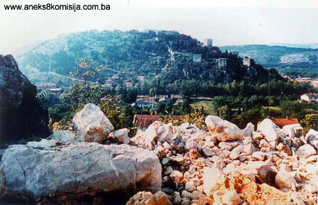
Stolac Old Town is situated on the dome-shaped hill known as Veli-dedino brdo, whose western slope towards Zagrad mahala (quarter) is known as Šetnica, the northern slope facing the present town centre is known as Carinska side, and the eastern slope towards Uzinovići street is known as Križevac. The Old town is situated on the left bank of the Bregava river, above Stolac, with a view over the town, the fertile Vidovo plain, the Bregava river and the surrounding hills: Hrgud to the north, Komanje hill to the east, Ošanići to the west and Bašnik rise to the south, and the end of Vidovo plain.
Historical information
The names Stolac and Vidoški appear alternatively in historical sources until almost the end of the nineteenth century(1).
It is believed that in prehistoric times there was a human settlement in the north-western part of the fortifications, in the Podgrad area, on the part of the hill called Šetnica. Late antique strata have been excavated on the north side of gthe town (towers I-IV). The site of present-day Stolac was where the municipium of Dilumtum stood in antique times; finds dating to the first to fourth centuries CE have been excavated along with late antique fortifications (Sergejevski, 1935, 17 and other). "Below the old Turkish remains of the fort of Stolac, there is a large field in the valley with Roman ruins. The field extends along the base of hill on which the fortress stands, from the Catholic Church to the Bregava, a length of 1 KM and width of 0.5 km." (Truhelka: 1979).
In the middle ages the area of Stolac town belonged to the župa of Vidoši. There is reference in 1417 to Vidovo plain, as "Planum Sancti Viti". (Dinić: 1938, 182), but the first reliable reference to mediaeval Stolac dates from 1420, as "Loco dicto Stolac" in relation to some merchants who were robbed (D. Kovačević – Kojić: 1972, p. 118 note 40; M. Vego: 1957, p. 124)(3); it reappears few years later, in 1436 (M. Dinić, 1938, p.182).
The first reference to Vidovški town is in a charter dated 19 February 1444, followed by a further series of charters up to 1454, as a possession of Stjepan Vukić Kosača. (M. Dinić, 1938, 182). Archaeological works in 1976 did not reveal anything that was clearly from the mediaeval town, but the assumption is that they lie under the fort dating from the Austro-Hungarian administration.
In Dubrovnik sources dating from 1463, the town of Vidovški, meaning the Stolac fort and the settlement below it, is referred to under the name of Stolac. Stolac become part of the Ottoman sultanate after it was taken on 13 June 1456, but there is no reliable evidence of a garrison having been maintained here until the early eighteenth century. During the Candian and Viennese wars (1645 – 1660 and 1683 – 1699) Venetian troops launched several attacks on Stolac (January 1663; 1664; 30/071678; 1794 or 1795). Following the 1699 Treaty of Karlowitz, the town was repaired and enlarged, and became an administrative centre headed by a dizdar. In about 1706 the kapetanija of Stolac was founded.
The town was twice struck by lightning (1757/58 and 1849/41), which on both occasions caused gunpowder to explode, causing considerable damage. On the first occasion it was repaired in 1768, when the kapetans of Stolac were the Šarić family, and on the second when Ali-paša Rizvanbegović was kapetan of Stolac.
In the year 1832, the army of Husein Kapetan Gradašćević set siege to Stolac, but to no avail. From 1835, when the posts of kapetan and dizdar were abolished, until 1878 only a small garrison was maintained in the city. Austrian rule was established in August 1878. The old fortifications were repaired out of the military coffers in 1883, and in 1888 a modern fort was built above the site of the fortress dating from the time of Ottoman rule.
Legal status to date
Pursuant to the law and by Ruling of the Institute for the Protection of Cultural Monuments No. 573/52 dated 09/10/1952, the Fort in Stolac was placed under the protection of the state as an important cultural and historical monument.
By Ruling of Institute for the Protection of Cultural Monuments of NR BiH No. 02-682-3 dated 08/04/1962 in Sarajevo, the Stolac Fort, the property of the state, standing on c.p. No. 215/1, sheet 312 of the property holdings register; immovable property with a surface area of 247019 sq.m., was to be entered in the Register of immovable cultural monuments under reg. No. 191.
The Stolac Fort is on the Provisional List of National Monuments as no. 578.
In the Regional Plan for Bosnia and Herzegovina, the earlier protected status of Stolac Old Town was confirmed, and the monument was defined as a Category 1 monument or as the "most significant representative of its kind with a high level of accomplishment, and of national importance".
2. Description of the monument
Architecture
The old fortified town of Stolac stands on an elevation overlooking the centre of present-day Stolac, and is one of the largest of its kind in Bosnia and Herzegovina. The complex system of stone walls and towers suggests that it evolved in several stages, but these are hard to differentiate.
The basic and principal structure, part of the present-day ramparts lying on the slope above Stolac, consist of walls built using the technique of of stratified opus incertum, typical of the fourth century in this region. All that has been determined with certainty is that tower II, dating from the Ottoman period, was built on a late antique substructure. The ground plan of the late antique fortifications has specific features of Greek building in the Hellenist tradition (Đ. Basler 1972, pp. 51-52). At that time the fort was one of a chain of forts (castrum) together with Koštura near Dabrica and Blagaj on the Buna.
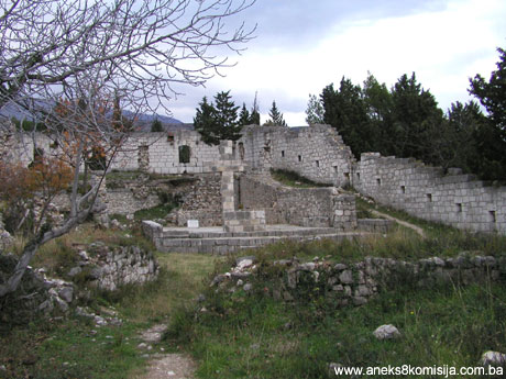
In the seventeenth century the town had thirteen towers and keeps, and was the most highly fortified town in Herzegovina. Part of the structure on the plateau of the hill belongs to a later stage. This part of the fortifications was razed to the ground in the late nineteenth century when a fort was build for the Austro-Hungarian garrison.
The Old Town covers an area of 20,503 sq.m. Its defences consist of a series of stone towers and ramparts, the latter 2 m. thick and made from cut limestone blocks – “sivac” from the local quarry. As well as the towers, the fort has ten water cisterns, a storeroom for flour, residential quarters and a mosque. The mosque fell into ruin in 1906 and was never rebuilt, but its remains are still visible.
The fortress as a whole consists of three clearly differentiated ensembles:
- Lower town – on the north-west (the area beneath the Austro-Hungarian part of the fort, located north-west of this part of the fort) with a surface area of 8,481 sq.m.
- Middle town - (the part built during Austro-Hungarian rule and the plateau of the hill) covering 7,005 sq.m
- Upper town - (the part above Middle town, located to the east of it) covering 8,579 sq.m.
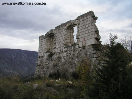
1. The Lower town is surrounded on three sides – to the north-east, north and south-west – with towers and ramparts. The main town gate is in the north-east wall, which is 44.95 m. long. The gate is arched, and has a stone-floored guardroom above the arch. The mosque, with a surface area of 113.24 sq.m., is located above the entrance to the fort, and observations to date suggest that it has a water tank under the floor. It is impossible to determine the depth of the tank beneath the mosque floor given that it has been filled with broken stone, probably belonging to the mosque itself, and soil. The only name by which the mosque in the fortress is known is the Veli-dedina mosque, and tradition links its date of origin with the cave in the rock beneath it which was used as a place of prayer in the pre-Ottoman era in Bosnia. On the south wall of the ruined mosque remains of a stone minaret and mihrab can be seen. The remains of the mihrab suggest the workmanship typical of the oldest mosques in Bosnia and Herzegovina: precisely cut complex stalactite decorations in seven horizontal rows with polychrome pigment directly applied to the miljevina (a type of local limestone). Traces of red pigment and black lines indicate a date of the early sixteenth century as the time when the mihrab was painted. Small pieces of saw-cut miljevina are held together with small wrought-iron cramps. Since this part of the fort has never been properly studied, the assumption may be made that the space beneath the level of the mosque floor or an extension of it into the hillslope served as a deep cistern. This assumption is reinforced by the surviving name of the mosque, which is associated with a Sufi leader in relation to whom there is a tradition, so far uncorroborated, that he was an old man when Sandalj was alive(4).
The walls of the mosque were about 1 m. thick, and the stone-built minaret was octagonal in shape. Austro-Hungarian troops used the mosque as a storeroom for ten years, and pulled it down in 1888.
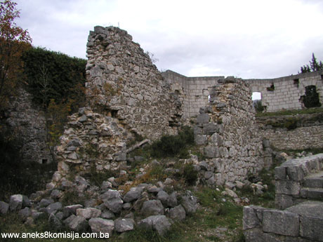
The northern area consists of four tall towers linked by ramparts with two rows of loopholes. Tower I, at the angle of the south ramparts, has a surface area of 96.72 sq.m. and is semi-ruinous. Between this tower and the entrance gate is a large cistern with two doors, now walled up with stone. Tower II is much better preserved, and covers an area of 108.29 sq.m. Tower III has an area of 107.20 sq.m.
Tower IV stands on the north-west angle and occupies an area of 107.20 sq.m. The walls of this tower survive to a height of 12 m. The wall between the first and second towers is 22.25 m. long, between the second and the third 25.50 m., and between the third and fourth 22.25 m. Access to the walls linking these four towers is difficult, the walls are high, and are equipped with two rows of loopholes, with two stages of construction discernible. The wall between towers II and III is in a ruinous state and sags outwards by some 50 cm. The walls of tower III are cracked by the effects of an earthquake, and were repaired with concrete in 1939. The ramparts between towers IV and V is 29.62 m. long. Tower V has an area of 116.46 sq.m. On this tower, which is almost ruined, the original beams can still be seen. The ramparts linking tower V and tower VI is 41.60 m. long. Tower VI, which is the best preserved, covers an area of 97.52 sq.m. The entire tuff vault has survived. Between towers V and VI there is a water tank, now reduced to rubble. Between towers III and IV is a passage leading down to the town, which was used in times of danger. The ramparts linking tower VI and tower VII is 22.75 m. long and forms the connection with tower VII, which has an area of 105.30 sq.m. The length of the wall from this tower to the furthest corner is 36.62 m. Here there stands tower VIII, with a surface area of about 65.11 sq.m. Above this tower is a natural passage similar to the one at tower IV. The ramparts and towers of this north-western part are in varying states of preservation, since in some parts there were two stages and in others three stages of construction. The oak beams and loopholes set in two rows one above the other probably date from the Turkish period. There can be no doubt of the existence of mediaeval elements in the fortifications, in the foundations and lowest structural levels, which should be clarified in forthcoming investigations.
2. The Middle town, with an area of 2,005 sq.m., occupies the central area of the complex. This part was built of white cut limestone from Brač. A number of facilities were built for the garrison. Parts of the old walls were used to built new buildings. This complex had three water tanks, fortified ramparts and a munitions depot. Its walls are fairly badly damaged, and the entrance gate has been rebuilt.
3. The Upper town is located almost at the same height as the Middle town and to the east of it. At the time it was built, part of the fort, ramparts and towers was destroyed and area was levelled, as can be assumed from the remains of the walls and foundations. This part occupies an area of 87.79 sq.m. and has five towers. Tower IX has an area of 93.39 sq.m. The length of the ramparts between tower VIII and tower IX, visible in the Austro-Hungarian fort, is 113.62 m. From this tower to the next at the north-eastern corner where tower X stands, the ramparts are 48.40 m long; the tower has an area of 104.53 sq.m.. From that corner to the central east tower, tower XI, is a wall 33.88 m. long; the area of the tower is 231.70 sq.m.. From here to the south-east tower, tower XII, are ramparts 42.42 m long; the area of the tower is 86.72 sq.m.. The wall from the last tower, tower XIII on the south, is 40.00 m in length. This tower, which served as an ammunition and explosives depot, was twice destroying by being struck by lightning. The area of the tower is 69.16 sq.m., and the length of the wall from this tower to the south-eastern corner is 94.50 m.
In the area of the surviving ensemble by the road toward the gates and directly beneath the ramparts of Lower town are colonies of naturalized cyclamen [species unspecified], which are preserved by this decision as an integral part of the ensemble.
3. Research and conservation and restoration works
Small-scale archaeological research and topographical studies were conducted by P. Anđelić and I. Rizvanbegović in the presence of architect Prof. Džemal Celić and architect Aleksandra Ninkovića in 1975-1977 under the aegis of the project "The history of the architecture and art of the mediaeval Vidovška fort in Stolac".
4. Present condition of the site
An on-site inspection in December 2002 determined as follows:
Ÿ The site is at risk of rapid deterioration as a result of lack of maintenance and failure to implement even minimal protection measures; large quantities of fallen material are visible in the gates, along the walls and in the passages of the underground parts of the old town;
Ÿ Cracks are clearly visible in the ramparts and walls of the fortress; these are both deep and long, and there is a danger of the towers collapsing;
Ÿ Fourteen wooden crosses have been erected within the protected site and a stone cross more than 4 m high on the plateau of the middle town with parts of the lower stone wall around the cross; both the stone cross and parts of the walls around it have been constructed from stone taken from the ramparts of the fortress;
Ÿ The protected site is endangered by new and inappropriate construction in the immediate protected area;
Ÿ Quantities of building materials (sand, cement, wire-mesh reinforcements, etc.) possibly indicating further intended construction;
Ÿ The access route, which is an integral part of the protected site, is used for motor vehicle traffic, which thus at risk of destruction, as is the vegetation forming an integral part of the protected site.
III - CONCLUSION
Applying the Criteria for the adoption of a decision on proclaiming an item of property a national monument, adopted at the fourth session of the Commission to Preserve National Monuments (3 to 9 September 2002), the Commission has enacted the Decision cited above.
The Decision was based on the following criteria:
A. Time frame
B. Historical value
D. Clarity (documentary, scientific and educational value)
D.i.. material evidence of a lesser known historical era
D.ii. evidence of historical change
D.iv. evidence of a certain type, style or regional mannter
D.v. evidence of a typical lifestyle of a given period
E. Symbolic value
E. i. ontological value
E.ii. sacral value
E.iii. traditional value
E.iv. relation to rituals or traditions
E.v. significance for the identity of a group of people
F. Townscape/landscape value
F.i. relation to other parts of the ensemble
F.ii. meaning in the townscape
F.iii. the building or group of buildings is part of a group or site.
G. Authenticity
G. i. form and design
G.iii. use and function
G.v. location and setting
H. Rarity and representativity
H.i. Unique or rare example of a specific type or style
I. Integrity (groups, sites, collections)
I.i. physical coherence
The following documents form an integral part of this Decision:
• Photodocumentation;
• Drawings
The documentation annexed to the Decision is public and available for view by interested persons on written request to the Commission to Preserve National Monuments of Bosnia and Herzegovina.
Bibliography
Basler, Đ., Arhitektura kasnoantičkog doba u Bosni i Hercegovini (Architecture of the Late Middle Ages in Bosnia and Herzegovina), Sarajevo, 1972.
Ćurić, H., Stolački stari grad (Stolac Old Town) Slovo Gorčina, 1977.
Dinić, M., Zemlje hercega sv. Save, (Lands of Herzeg St. Sava) Journal of the Serbian Royal Academy CLXXXII, 2nd grade, 92. Belgrade, 1940, 149-256.
Kreševljaković, H., and Kapidžić, H., Stari hercegovački gradovi (Old Towns of Herzegovina) Naše starine II, 1954, 9-21.
Rizvanbegović, I, The results of Former Archaeological Researches at the Medieval Fortress of Vidoška Tvrđava at Stolac., Balcanoslovica 8, Belgrade, 1979, 77-92.
Sergejevski, D. Iz rimske arheologije (Municipium Diluntum) (From Roman Archaeology [Municipium Diluntum]) Journal of the National Museum XLVII, 1935, 17-22
Truhelka, Ćiro, Rimske razvaline kod Stoca i okolici (Roman remains near Stolac and environs) Slovo Gorčina, Stolac 1979.
Vego, M. Naselja bosanske srednjovjekovne države (Settlements of the Bosnian medieval state), Sarajevo, 1957.
|